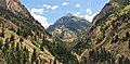
Mears Peak is a 13,496-foot-elevation (4,114-meter) mountain summit located on the common boundary of Ouray County with San Miguel County, in Colorado, United States. It is situated six miles northwest of the community of Telluride, in the Mount Sneffels Wilderness, on land managed by Uncompahgre National Forest. It is part of the Sneffels Range which is a subset of the San Juan Mountains, which in turn is part of the Rocky Mountains. Mears Peak is situated west of the Continental Divide, and 3.8 miles west of Mount Sneffels. Topographic relief is significant as the south aspect rises 4,900 feet above the San Miguel River in approximately 5.5 miles.
Sunshine Mountain is a 12,930-foot-elevation (3,940-meter) mountain summit located in San Miguel County, in Colorado, United States. It is situated nine miles southwest of the community of Telluride, in the Lizard Head Wilderness, on land managed by Uncompahgre National Forest. It is part of the San Juan Mountains which is a subset of the Rocky Mountains. Sunshine Mountain is situated 24 miles west of the Continental Divide, 2.75 miles east of Wilson Peak, and 1.8 mile northeast of Lizard Head, the nearest higher neighbor. Topographic relief is significant as the west aspect rises 2,700 feet above Bilk Creek in approximately one mile. The mountain is composed of rock of the San Juan Formation overlaying Telluride Conglomerate, in turn overlaying Mancos Shale. The mountain's name, which has been officially adopted by the United States Board on Geographic Names, was in use before 1899 when Henry Gannett published it in A Dictionary of Altitudes in the United States.
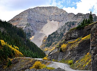
Potosi Peak is a 13,786-foot-elevation (4,202-meter) mountain summit located in Ouray County of Colorado, United States. It is situated five miles southwest of the community of Ouray, on land managed by Uncompahgre National Forest. It is part of the Sneffels Range which is a subset of the San Juan Mountains, which in turn is part of the Rocky Mountains. It is situated west of the Continental Divide, 2.2 miles south of Whitehouse Mountain, and 2.5 miles southeast of Mount Sneffels. Potosi ranks as the 113th-highest peak in Colorado, and the fourth-highest in the Sneffels Range. Recreation enthusiasts heading for Yankee Boy Basin traverse below the southern base of the mountain. Topographic relief is significant as the southeast aspect rises 4,000 feet above the Camp Bird Mine in approximately 1.5 mile. The mining activity in the immediate area produced significant amounts of gold and silver. "Potosi" in Quechuan language translates to "great wealth.". The mountain's name, which has been officially adopted by the United States Board on Geographic Names, was in use before 1899 when Henry Gannett published it in A Dictionary of Altitudes in the United States.
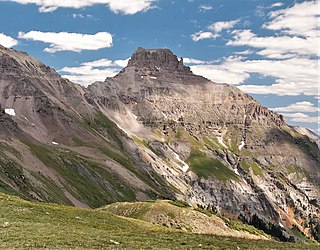
Coxcomb Peak is a 13,656-foot-elevation (4,162-meter) mountain summit located on the common boundary of Hinsdale County and Ouray County, in Colorado, United States. It is situated nine miles northeast of the community of Ouray, in the Uncompahgre Wilderness, on land managed by Uncompahgre National Forest. It is part of the San Juan Mountains which are a subset of the Rocky Mountains, and is situated west of the Continental Divide. Coxcomb ranks as the 171st-highest peak in Colorado, and topographic relief is significant as the south aspect rises 2,000 feet above Wetterhorn Basin in approximately one mile, and 4,400 feet above Cow Creek in three miles. Neighbors include Precipice Peak 2.7 miles to the north, Redcliff one-half mile north, Matterhorn Peak 2.3 miles to the east-southeast, and nearest higher neighbor Wetterhorn Peak 1.8 mile to the southeast. The mountain's descriptive name, which has been officially adopted by the United States Board on Geographic Names, was in use since at least 1906 when Henry Gannett published it in the Gazetteer of Colorado.

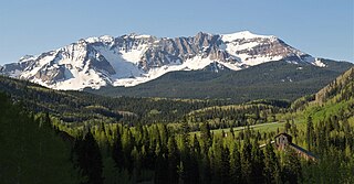
Whitehouse Mountain is a 13,492-foot-elevation (4,112-meter) mountain summit located in Ouray County of southwest Colorado, United States. It is situated four miles west of the community of Ouray, on land managed by Uncompahgre National Forest. It is part of the Sneffels Range which is a subset of the San Juan Mountains, which in turn is part of the Rocky Mountains. It is west of the Continental Divide, 2.2 miles north of Potosi Peak, and 3.2 miles east-northeast of Mount Sneffels. Topographic relief is significant as the east aspect rises 5,680 feet above the town of Ouray in approximately four miles. The mountain's name, which has been officially adopted by the United States Board on Geographic Names, was in use before 1906 when Henry Gannett published it in the Gazetteer of Colorado.

Mount Ridgway is a 13,468-foot-elevation (4,105-meter) mountain summit located in Ouray County of southwest Colorado, United States. It is situated five miles west of the community of Ouray, on land managed by Uncompahgre National Forest. It is part of the Sneffels Range which is a subset of the San Juan Mountains, which in turn is part of the Rocky Mountains. It is west of the Continental Divide, 2.2 miles east-northeast of Mount Sneffels, and 0.95 miles southwest of Whitehouse Mountain, which is the nearest higher neighbor. Topographic relief is significant as the west aspect rises 3,000 feet above Blaine Basin in one mile.

Stony Mountain is a 12,698-foot-elevation (3,870-meter) mountain summit located in Ouray County of southwest Colorado, United States. It is situated five miles southwest of the community of Ouray, on land managed by Uncompahgre National Forest. It is part of the Sneffels Range which is a subset of the San Juan Mountains, which in turn is part of the Rocky Mountains. It is situated west of the Continental Divide, 1.3 miles southwest of Potosi Peak, and 1.15 miles northeast of parent Mount Emma. Yankee Boy Basin is surrounded by Stony Mountain, Gilpin Peak, Mount Sneffels, Cirque Mountain, and Teakettle Mountain. Topographic relief is significant as the east aspect rises 2,000 feet above Sneffels Creek in less than one mile. The mountain's name, which has been officially adopted by the United States Board on Geographic Names, was in use before 1899 when Henry Gannett published it in A Dictionary of Altitudes in the United States.

Darley Mountain is a 13,260-foot-elevation (4,042 meter) mountain summit located on the shared boundary of Hinsdale County with Ouray County, in southwest Colorado, United States. It is situated five miles southeast of the community of Ouray, in the Uncompahgre Wilderness, on land managed by Uncompahgre National Forest. It is part of the San Juan Mountains which are a subset of the Rocky Mountains, and is west of the Continental Divide. Neighboring geographic features include Engineer Pass 0.6 mile to the southeast, Engineer Mountain 0.9 mile to the south, and nearest higher neighbor Wildhorse Peak 2.2 miles to the north. The mountain's name was officially adopted in 1992 by the United States Board on Geographic Names to commemorate George Marshall Darley (1847–1917), pioneering minister of the San Juan Mountains, who founded and built the first church in western Colorado in Lake City in 1876. Lake City is approximately 16 miles east of this mountain.
United States Mountain is a 13,036-foot-elevation (3,973-meter) mountain summit located in Ouray County of southwest Colorado, United States. It is situated six miles southwest of the community of Ouray, on land managed by Uncompahgre National Forest. It is part of the Sneffels Range which is a subset of the San Juan Mountains, which in turn is part of the Rocky Mountains. It is set west of the Continental Divide, 2.3 miles south of Potosi Peak, and 2.5 miles southeast of Stony Mountain. Recreation enthusiasts heading for Yankee Boy Basin traverse below the northern base of the mountain. Topographic relief is significant as the north aspect rises 3,300 feet above the Camp Bird Mine in approximately one mile. Mining activity in the immediate area produced significant amounts of gold and silver. The Hidden Treasure Mine is a gold mine located on the south slope at 11,759-feet elevation.

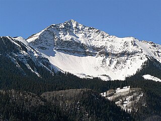
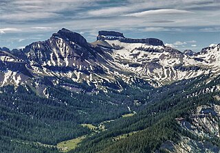
Cirque Mountain is a 13,686-foot-elevation (4,171-meter) mountain summit located in Ouray County of southwest Colorado, United States. It is situated six miles west of the community of Ouray, above the north side of Yankee Boy Basin, on land managed by Uncompahgre National Forest. It is part of the Sneffels Range which is a subset of the San Juan Mountains, which in turn is part of the Rocky Mountains. Cirque ranks as the 155th-highest peak in Colorado, and the ninth-highest in the Sneffels Range. It is west of the Continental Divide, 1.12 mile east of Mount Sneffels, and 0.59 mile west of Teakettle Mountain, which is the nearest higher neighbor. Topographic relief is significant as the north aspect rises 3,000 feet above Blaine Basin in one mile, and the south aspect rises over 2,000 feet above Yankee Boy Basin in less than one mile. These basins are cirques which were carved by ancient glaciers. The mountain's name has been officially adopted by the United States Board on Geographic Names.

Chimney Rock is an 11,781-foot-elevation (3,591-meter) pillar located on the shared boundary of Hinsdale County with Ouray County, in southwest Colorado, United States. It is situated 10.5 miles east of the community of Ridgway, and immediately south of Owl Creek Pass, in the Uncompahgre Wilderness, on land managed by Uncompahgre National Forest. Owl Creek Pass separates Chimney Rock from Cimarron Ridge to the north. It is part of the San Juan Mountains which are a subset of the Rocky Mountains, and is situated west of the Continental Divide. Chimney Rock is the steepest point in Colorado with an average steepness of 61.4 degrees. Topographic relief is significant as the east aspect rises 1,600 feet above West Fork Cimarron River in one-half mile. Chimney Rock can be seen from Highway 550 near Ridgway. This feature's name was officially adopted by the United States Board on Geographic Names in 1966, prior to that it was known as Chimney Peak. The first ascent was made in 1934 by Melvin Griffiths and Robert Ormes via the 400-foot south face, which is the only established climbing route.

Courthouse Mountain is a 12,152-foot-elevation (3,704-meter) mountain summit located on the shared boundary of Hinsdale County with Ouray County, in southwest Colorado, United States. It is situated 10.5 miles east of the community of Ridgway, and south of Owl Creek Pass, in the Uncompahgre Wilderness, on land managed by Uncompahgre National Forest. It is part of the San Juan Mountains which are a subset of the Rocky Mountains, and is situated west of the Continental Divide. Topographic relief is significant as the east aspect rises nearly 2,000 feet above West Fork Cimarron River in approximately one-half mile, and with its prominence can be seen from Highway 550 near Ridgway. The mountain's name, which has been officially adopted by the United States Board on Geographic Names, was in use before 1906 when Henry Gannett published it in the Gazetteer of Colorado.

Wildhorse Peak is a 13,266-foot-elevation (4,043-meter) mountain summit located in Ouray County, of Colorado, United States. It is situated five miles east of the community of Ouray, in the Uncompahgre Wilderness, on land managed by Uncompahgre National Forest. It is part of the San Juan Mountains which are a subset of the Rocky Mountains, and is situated west of the Continental Divide. Neighbors include Darley Mountain 2.2 miles to the south, and Abrams Mountain five miles to the southwest. This distinctive peak abruptly rises 1,000 feet above the alpine tundra of American Flats, and topographic relief is significant as the northwest aspect rises 1,600 feet above Wildhorse Creek in less than one mile. The peak can be seen from Montrose and Highway 550. The first ascent of the summit was made August 25, 1899, by Eli Stanton, F. H. Stanton, and William Killen. The mountain's name, which has been officially adopted by the United States Board on Geographic Names, was in use in 1906 when Henry Gannett published it in A Gazetteer of Colorado.

Golden Horn is a 13,780-foot-elevation (4,200-meter) mountain summit located on the shared boundary of San Juan County with San Miguel County, in southwest Colorado, United States. It is situated nine miles west of the community of Silverton, on land managed by San Juan National Forest and Uncompahgre National Forest. Golden Horn is part of the San Juan Mountains which are a subset of the Rocky Mountains, and is west of the Continental Divide. It ranks as the 116th-highest peak in Colorado, and topographic relief is significant as the west aspect rises 3,800 feet in approximately 1.5 mile. The mountain's name, which has been officially adopted by the United States Board on Geographic Names, was in use in 1906 when Henry Gannett published it in A Gazetteer of Colorado.

Hurricane Peak is a 13,447-foot-elevation (4,099-meter) mountain summit located in San Juan County of southwest Colorado, United States. It is situated equidistant between the historic towns of Ouray and Silverton, and is approximately nine miles west of the Continental Divide. It is part of the San Juan Mountains which are a subset of the Rocky Mountains. Topographic relief is significant as the north aspect rises 1,200 feet above Lake Como in one-half mile. Neighbors include Abrams Mountain 3.4 miles to the north, Red Mountain 2.2 miles to the west, and Tuttle Mountain 1.4 mile to the north. The Mountain Queen Mine, which is located on the east slope of Hurricane Peak at the head of California Gulch, is one of the oldest workings in the area and was most active from 1878 to 1880. The mountain's name, which has been officially adopted by the United States Board on Geographic Names, was in use in 1906 when Henry Gannett published it in the Gazetteer of Colorado.

Chicago Peak is a 13,385-foot-elevation (4,080-meter) mountain summit located on the shared boundary of San Miguel County with Ouray County in southwest Colorado, United States. It is situated four miles (6.4 km) east of the community of Telluride, on land managed by Uncompahgre National Forest. It is part of the Sneffels Range which is a subset of the San Juan Mountains, which in turn are part of the Rocky Mountains. It is set above the ghost town of Tomboy, one mile (1.6 km) south of United States Mountain, and one mile northwest of Imogene Pass. Topographic relief is significant as the east aspect rises 2,000 feet above Imogene Basin in approximately one mile, and the west aspect rises 2,000 feet above Savage Basin in less than one mile. Mining activity in the immediate area produced significant amounts of gold and silver.

Lookout Peak is a 13,661-foot-elevation (4,164-meter) mountain summit located on the shared boundary of San Juan County with San Miguel County, in southwest Colorado, United States. It is situated three miles east of the community of Ophir, and one mile immediately north of Ophir Pass, on land managed by San Juan National Forest and Uncompahgre National Forest. Lookout Peak is part of the San Juan Mountains which are a subset of the Rocky Mountains, and is west of the Continental Divide. It ranks as the 166th-highest peak in Colorado, and topographic relief is significant as the west aspect rises 3,000 feet in approximately one mile. Neighbors include Silver Mountain three miles to the west-northwest, Wasatch Mountain two miles north-northwest, and Golden Horn five miles south-southwest. The mountain's name, which has been officially adopted by the United States Board on Geographic Names, was in use in 1899 when Henry Gannett published it in A Dictionary of Altitudes in the United States, and in 1906 when he published it in A Gazetteer of Colorado.
Sheep Mountain is a 13,188-foot-elevation (4,020-meter) mountain summit located on the shared boundary of Dolores County with San Miguel County, in southwest Colorado, United States. It is situated three miles south of Trout Lake and two miles southeast of Lizard Head Pass, on land managed by San Juan National Forest and Uncompahgre National Forest. Sheep Mountain is part of the San Juan Mountains which are a subset of the Rocky Mountains, and is west of the Continental Divide. Topographic relief is significant as the southwest aspect rises 3,200 feet above the Dolores River in approximately 2.5 miles. Neighbors include Golden Horn and Vermilion Peak to the east, and Lizard Head to the northwest. Sheep Mountain can be seen from the San Juan Skyway in the Lizard Head Pass and Trout Lake areas. The mountain's name, which has been officially adopted by the United States Board on Geographic Names, was in use in 1906 when Henry Gannett published it in A Gazetteer of Colorado.
Brown Mountain is a 13,347-foot-elevation (4,068-meter) summit located on the boundary shared by Ouray County with San Juan County in Colorado, United States.

Engineer Mountain is a 13,225-foot-elevation (4,031 meter) summit located on the boundary shared by Hinsdale County with Ouray County, in Colorado, United States.