American Peak

Last updated
American Peak
American Peak, Colorado.jpg
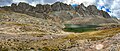
North aspect, with Sloan Lake
Highest point
Elevation 13,806 ft (4,208 m) [1]
Prominence 446 ft (136 m) [1]
Parent peak Jones Mountain (13,866 ft) [2]
Isolation 0.79 mi (1.27 km) [2]
Coordinates 37°53′58″N107°30′45″W / 37.8994199°N 107.5124755°W / 37.8994199; -107.5124755 [3]
Geography
USA Colorado relief location map.svg
Red triangle with thick white border.svg
American Peak
Location in Colorado
Usa edcp relief location map.png
Red triangle with thick white border.svg
American Peak
American Peak (the United States)
Location Hinsdale County
Colorado, US
Parent range Rocky Mountains
San Juan Mountains
Topo map USGS Handies Peak
Climbing
Easiest route class 2 [2] West ridge

American Peak is a 13,806-foot-elevation (4,208-meter) mountain summit located in Hinsdale County, of southwest Colorado, United States. [3]

Contents

Description

American Peak is situated 11 miles northeast of the community of Silverton, on land managed by the Bureau of Land Management. It is part of the San Juan Mountains which are a subset of the Rocky Mountains, and is situated four miles west of the Continental Divide. American Peak ranks as the 102nd-highest peak in Colorado, [2] and topographic relief is significant as the south aspect rises 2,800 feet (850 meters) above Snare Creek in approximately 1.5 mile. Neighbors include Handies Peak one mile to the north-northeast, and Jones Mountain, 0.8 mile to the west-southwest. The mountain's toponym was officially adopted in 2005 by the United States Board on Geographic Names to recognize the American spirit and heritage, and the summit's proximity to American Basin. [3]

Climate

According to the Köppen climate classification system, American Peak is located in an alpine subarctic climate zone with cold, snowy winters, and cool to warm summers. [4] Due to its altitude, it receives precipitation all year, as snow in winter and as thunderstorms in summer, with a dry period in late spring. Precipitation runoff from the mountain drains into tributaries of the Gunnison River.

See also

References

  1. 1 2 "American Peak, Colorado". Peakbagger.com.
  2. 1 2 3 4 "American Peak - 13,806' CO". listsofjohn.com. Retrieved 2021-07-04.
  3. 1 2 3 "American Peak". Geographic Names Information System . United States Geological Survey, United States Department of the Interior . Retrieved 2021-07-04.
  4. Peel, M.C.; Finlayson, B.L. & McMahon, T.A. (2007). "Updated world map of the Köppen-Geiger climate classification" (PDF). Hydrology and Earth System Sciences . 11 (5): 1633–1644. Bibcode:2007HESS...11.1633P. doi: 10.5194/hess-11-1633-2007 . Archived (PDF) from the original on 2019-12-02. Retrieved 2025-11-07.