
Dowsby is a village and civil parish in the South Kesteven district of Lincolnshire, England. It is situated on the western edge of The Fens at the junction of the east-west B1397 road and the north-south B1177. It is 1 mile (1.6 km) north-east from Rippingale and just south of Pointon. The civil parish includes the hamlet of Graby. Nearby to the east, along the B1397 at Dowsby Fen, is Car Dyke. The civil parish population taken at the 2011 census was 204.

Aveland was a Wapentake of Kesteven from the time of the Danelaw until the Local Government Act 1888. Its meeting place was The Aveland at grid reference TF 0675 2961 in the parish of Aslackby.

Aslackby and Laughton is a civil parish in the South Kesteven district of Lincolnshire, England. According to the 2001 census the parish had a population of 243, in 102 households. increasing slightly to 251 in 118 households at the 2011 census. It consists of the village of Aslackby, the hamlet of Laughton, and scattered farms, and part of the hamlet of Graby.

Aunsby and Dembleby is a civil parish in the North Kesteven district of Lincolnshire, England. According to the 2001 Census it had a population of 125. The parish includes Aunsby and Dembleby, which were separate parishes until 1931, and the hamlet of Scott Willoughby.

Billingborough is a village and civil parish in the South Kesteven district of Lincolnshire, England. It is situated approximately 10 miles (16 km) north of Bourne and 10 miles south of Sleaford, and on the B1177 between Horbling and Pointon just south of the A52.
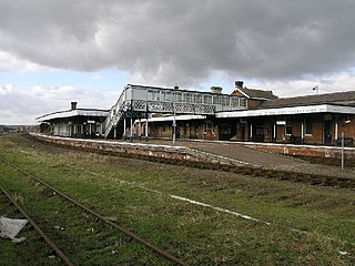
Sleaford railway station serves the town of Sleaford in Lincolnshire, England. It lies on the Peterborough–Lincoln line. The station is 21.25 miles (34 km) south of Lincoln Central.

Horbling is a village and civil parish in the South Kesteven district of Lincolnshire, England. It lies on the B1177, 7 miles (11 km) south-east of Sleaford, 14.5 miles (23 km) north-east of Grantham and 0.5 miles (0.8 km) north of Billingborough.

Rippingale is a village and civil parish in the South Kesteven district of Lincolnshire, England. The population of the civil parish was 929 at the 2011 census. The village is situated on the A15 road, about 5 miles (8 km) north from Bourne.
North Drove railway station was a station serving Pode Hole in Lincolnshire, England. It was on the route of the Spalding and Bourne Railway, later part of the Midland and Great Northern Joint Railway.

Twenty railway station served the village of Twenty, Lincolnshire. It was on the route of the Spalding and Bourne Railway, later part of the Midland and Eastern Railway and then part of the Midland and Great Northern Joint Railway main line between the Midlands and the Norfolk Coast.

Bourne was a railway station serving the town of Bourne in Lincolnshire which opened in 1860 and closed to passengers in 1959.

Counter Drain railway station was a remote station in Lincolnshire serving the village of Tongue End. It was on the route of the Spalding and Bourne Railway, later part of the Midland and Great Northern Joint Railway which ran across East Anglia to the Norfolk Coast. The station opened with the line on 1 August 1866, closed temporarily between 9 October 1880 and 1 February 1881, and closed permanently on 2 March 1959, although the line remained open for goods until 1964. The three intermediate stations between Spalding and Bourne had unusual names, because there were few nearby settlements; "Counter Drain" was the name of a drainage ditch close to the station.
Thurlby railway station was a station in Thurlby by Bourne, Lincolnshire on the Bourn and Essendine Railway between Essendine and Bourne. It was closed in 1951.

Braceborough Spa railway station was a station in Braceborough Spa, Lincolnshire on the Bourn and Essendine Railway between Essendine and Bourne. It was closed in 1951, along with the rest of the line.

Pinchbeck railway station was a station in Pinchbeck, Lincolnshire, England on the line between Spalding and Sleaford. The station opened in 1882, closed to passengers in 1961 and closed entirely in 1964.

Morton Road railway station was a station serving the village of Morton, Lincolnshire on the Great Northern Railway Bourne and Sleaford railway. It opened in 1872 and closed to passengers in 1930. The section from Bourne through Morton to Billingborough remained open for goods until 1965.

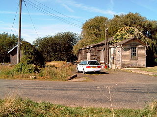
Rippingale railway station was a station serving the villages of Rippingale, Dowsby and Dunsby, Lincolnshire on the Great Northern Railway Bourne and Sleaford railway. It opened in 1872 and closed to passengers in 1930. The section from Bourne through Rippingale to Billingborough remained open for goods until 1964.

Aswarby and Scredington railway station was a station close to Scredington, Lincolnshire on the Great Northern Railway Bourne and Sleaford railway. It opened in 1872 and closed in 1930. It was originally shown on maps as Aswarby Station, but by 1905 it was shown as Aswarby and Scredington Station.
Mareham Lane is an unclassified road between Graby and Sleaford in Lincolnshire, England. It is approximately 10.6 miles (17.1 km) long.

The Bourne and Sleaford Railway was promoted as a branch of the Great Northern Railway to fend off an expected incursion by the rival Great Eastern Railway. It was authorised by Parliament in 1865, but not opened until 1871 and 1872. Although agricultural traffic provided healthy business, the rural character of the line never produced much passenger trade, and it was closed to passengers in 1930. The line was severed and ceased to be a through line in 1956 and closed completely in 1965.
