Fairview, California

Last updated

Fairview
CDP
Alameda County California Incorporated and Unincorporated areas Fairview Highlighted.svg
Location in Alameda County and the state of California
Usa edcp location map.svg
Red pog.svg
Fairview
Location in the United States
Coordinates: 37°40′43″N122°02′45″W / 37.67861°N 122.04583°W / 37.67861; -122.04583
Country Flag of the United States (23px).png  United States
State Flag of California.svg  California
County Alameda
Government
   State Senate Aisha Wahab (D) [1]
   State Assembly Liz Ortega (D) [2]
   U. S. Congress Kevin Mullin (D) [3]
Area
[4]
  Total
2.789 sq mi (7.22 km2)
  Land2.765 sq mi (7.16 km2)
  Water0.024 sq mi (0.06 km2)  0.85%
Elevation
[5]
597 ft (182 m)
Population
 (2020) [6]
  Total
11,341
  Density4,100/sq mi (1,600/km2)
Time zone UTC-8 (Pacific (PST))
  Summer (DST) UTC-7 (PDT)
ZIP code
94541, 94542
Area code(s) 510, 341
FIPS code 06-23350
GNIS feature IDswww.hhpoa.us 1867023, 2408104

Fairview is a census-designated place (CDP) in Alameda County, California, United States. It borders on the city of Hayward and the census-designated place of Castro Valley. The population was 11,341 at the 2020 census. [6]

Contents

Geography

According to the United States Census Bureau, the CDP has a total area of 2.8 square miles (7.3 km2), of which, 2.8 square miles (7.3 km2) is land and 0.02 square miles (0.052 km2) (0.85%) is water.

Demographics

Historical population
CensusPop.Note
U.S. Decennial Census [7]

2010

The 2010 United States Census [8] reported that 10,003 people, 3,490 households, and 2,512 families resided in the CDP. The population density was 3,617.7 inhabitants per square mile (1,396.8/km2). There were 3,642 housing units at an average density of 1,306.0 per square mile (504.2/km2). The racial makeup of the CDP was 45.0% White (36.2% non-Hispanic), 21.0% African American (20.5% non-Hispanic), 0.8% Native American, 15.2% Asian, 1.3% Pacific Islander, 9.1% from other races, and 7.6% from two or more races. 21.7% of the population was Hispanic or Latino of any race.

The Census reported that 98.5% of the population lived in households, 0.8% lived in non-institutionalized group quarters, and 0.7% were institutionalized.

There were 3,490 households, out of which 33.2% had children under the age of 18 living in them, 51.9% were opposite-sex married couples living together, 14.1% had a female householder with no husband present, and 6.0% had a male householder with no wife present. 5.6% of households were unmarried opposite-sex partnerships and 1.4% were same-sex married couples or partnerships. 20.2% of households were made up of individuals, and 6.8% had someone living alone who was 65 years of age or older. The average household size was 2.82 and the average family size was 3.24.

The population was spread out, with 20.7% under the age of 18, 8.4% aged 18 to 24, 26.3% aged 25 to 44, 31.9% aged 45 to 64, and 12.8% who were 65 years of age or older. The median age was 41.1 years. For every 100 females, there were 97.9 males. For every 100 females age 18 and over, there were 94.7 males.

There were 3,642 housing units, of which 3,490 were occupied, of which 78.0% were owner-occupied and 22.0% were occupied by renters. The homeowner vacancy rate was 1.8%; the rental vacancy rate was 5.1%. 75.9% of the population lived in owner-occupied housing units and 22.6% lived in rental housing units.

2000

As of the census [9] of 2000, there were 9,470 people, 3,281 households, and 2,427 families living in the CDP. The population density was 3,421.2 inhabitants per square mile (1,320.9/km2). There were 3,351 housing units at an average density of 1,210.6 per square mile (467.4/km2).

There were 3,281 households, out of which 32.7% had children under the age of 18 living with them, 58.2% were married couples living together, 11.6% had a female householder with no husband present, and 26.0% were non-families. 18.0% of all households were made up of individuals, and 6.0% had someone living alone who was 65 years of age or older. The average household size was 2.84 and the average family size was 3.22.

In the CDP, the population was spread out, with 24.1% under the age of 18, 7.1% from 18 to 24, 30.1% from 25 to 44, 26.9% from 45 to 64, and 11.8% who were 65 years of age or older. The median age was 39 years. For every 100 females, there were 98.1 males. For every 100 females age 18 and over, there were 96.1 males.

The median income for a household in the CDP was $76,647, and the median income for a family was $84,027. Males had a median income of $50,705 versus $41,599 for females. The per capita income for the CDP was $28,950. About 2.6% of families and 6.4% of the population were below the poverty line, including 4.5% of those under age 18 and 5.0% of those age 65 or over.

Signage at entrance to city and fire protection district Fairviewfireprotectiondistrict.jpg
Signage at entrance to city and fire protection district

Services

The Fairview Fire Protection District operates in Fairview. It is an independent special fire district in Alameda County, contracting with Hayward for emergency medical and other services, and has a fire station on Five Canyons Parkway. It has been in operation since 1938. [10]

Lone Tree Cemetery is located there, though it is often considered as being located in nearby Hayward, [11] and is the burial site for William Dutton Hayward, the namesake of Hayward.

Fairview is served by the Hayward Unified School District.

Related Research Articles

<span class="mw-page-title-main">Ashland, California</span> Unincorporated community in California, United States

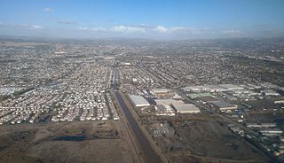
Ashland is a census-designated place (CDP) and unincorporated community in Alameda County, California, United States. The population was 23,823 at the 2020 census. Ashland is located between the city of San Leandro to the north, the unincorporated community of Cherryland to the south, the unincorporated community of Castro Valley to the east, and the unincorporated community of San Lorenzo to the southwest.

<span class="mw-page-title-main">Cherryland, California</span> Unincorporated Community in California, United States

Cherryland is an unincorporated community and census-designated place (CDP) in Alameda County, California, United States. Cherryland is located between Ashland to the north and the city of Hayward to the south. The population was 15,808 at the 2020 census.

<span class="mw-page-title-main">San Lorenzo, California</span> Unincorporated community in California, United States

San Lorenzo is a census-designated place (CDP) located in the East Bay of the San Francisco Bay Area in Alameda County, California, United States. The population was 29,581 at the 2020 census. It is an unincorporated community, located at the banks of San Lorenzo Creek. It was originally named Squattersville in 1851, but later renamed to San Lorenzo.

<span class="mw-page-title-main">Mesa, California</span> Census-designated place in California, United States

Mesa is a census-designated place (CDP) in Inyo County, California, United States. The population was 251 at the 2010 census, up from 214 at the 2000 census.

<span class="mw-page-title-main">Winton, California</span> Census-designated place in California, United States

Winton is an unincorporated community and census-designated place (CDP) in Merced County, California, United States. Winton is located 2.5 miles (4 km) north of Atwater, California. and 10 miles (16 km) northwest of Merced, the county seat. Winton was established along the original Santa Fe Railroad. At one time, passenger trains would stop at this location.

<span class="mw-page-title-main">Valle Vista, California</span> Place in California, United States

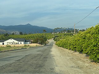
Valle Vista is a unincorporated area in Riverside County, California, United States and is located in the San Jacinto Valley. Valle Vista is adjacent to and east of the cities of San Jacinto and Hemet. The population was 11,036 at the 2010 census, up from 8,356 at the 2000 census. For statistical purposes, the United States Census Bureau has defined Valle Vista as a census-designated place (CDP).

<span class="mw-page-title-main">Bonsall, California</span> Census-designated place in California, United States

Bonsall is a census-designated place (CDP) in San Diego County, California. The population was 4,546 at the 2020 census, up from 3,982 at the 2010 census.

<span class="mw-page-title-main">Fairview Shores, Florida</span> Census-designated place in Florida, United States

Fairview Shores is a census-designated place and an unincorporated area in Orange County, Florida, United States. The population was 10,239 at the 2010 census. It is part of the Orlando–Kissimmee–Sanford, Florida Metropolitan Statistical Area.

<span class="mw-page-title-main">Hayward, Missouri</span> Census-designated place in Missouri, United States

Hayward is a census-designated place and former village in Pemiscot County, Missouri, United States. The population was 131 at the 2010 census.

<span class="mw-page-title-main">Fairview, Monmouth County, New Jersey</span> Populated place in Monmouth County, New Jersey, US

Fairview is an unincorporated community and census-designated place (CDP) in Middletown Township, Monmouth County, New Jersey, United States. As of the 2020 United States census, the CDP's population was 3,731.

<span class="mw-page-title-main">Morganville, New Jersey</span> Populated place in Monmouth County, New Jersey, US

Morganville is an unincorporated community and census-designated place (CDP) within Marlboro Township, in Monmouth County, New Jersey, United States. As of the 2020 census, the CDP's population was 6,203, up from 5,040 in 2010.

<span class="mw-page-title-main">Fairview, Dutchess County, New York</span> Census-designated place in New York, United States

Fairview is a hamlet and census-designated place (CDP) in Dutchess County, New York, United States. The population was 5,515 at the 2010 census. It is part of the Poughkeepsie–Newburgh–Middletown, NY Metropolitan Statistical Area as well as the larger New York–Newark–Bridgeport, NY-NJ-CT-PA Combined Statistical Area.

<span class="mw-page-title-main">Fairview, Westchester County, New York</span> CDP in New York, United States

Fairview is a hamlet and a census-designated place (CDP) located in the town of Greenburgh, Westchester County, New York, United States. The population was 3,099 at the 2010 census. As of 2000, Fairview had the fourth-highest percentage of African-Americans in New York.

<span class="mw-page-title-main">Mountain Home, North Carolina</span> Census-designated place in North Carolina, United States

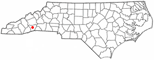
Mountain Home is an unincorporated community and census-designated place (CDP) in Henderson County, North Carolina, United States. The population was 3,622 at the 2010 census, up from 2,169 in 2000. It is part of the Asheville Metropolitan Statistical Area.

<span class="mw-page-title-main">Fairview Lanes, Ohio</span> Unincorporated community and Census-designated place in Ohio, United States

Fairview Lanes is an unincorporated community in Perkins Township, Erie County, Ohio, United States. The area was delineated as a census-designated place (CDP) for the 2000 census, at which time its population was 1,015. The area was not a CDP for the 2010 census. It is part of the Sandusky, Ohio Metropolitan Statistical Area.

<span class="mw-page-title-main">Avonia, Pennsylvania</span> Census-designated place in Pennsylvania, United States

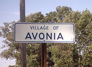
Avonia is an Village and census-designated place (CDP) in Erie County, Pennsylvania, United States. The population was 1,205 at the 2010 census, down from 1,331 in 2000. It is part of the Erie Metropolitan Statistical Area.

<span class="mw-page-title-main">Fairview-Ferndale, Pennsylvania</span> CDP in Pennsylvania, United States

Fairview-Ferndale is a census-designated place (CDP), located in Coal Township, in Northumberland County, Pennsylvania, United States. The population was 2,411 at the 2000 census.

<span class="mw-page-title-main">Fairview Beach, Virginia</span> Census-designated place in Virginia, United States

Fairview Beach is an unincorporated community and census-designated place (CDP) in King George County, Virginia, United States. The population was 391 at the 2010 census, which was up significantly from the 230 reported in 2000.

<span class="mw-page-title-main">Chief Lake, Wisconsin</span> CDP in Wisconsin, United States

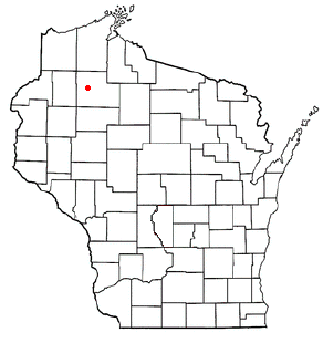
Chief Lake is a census-designated place (CDP) in the town of Hayward, Sawyer County, Wisconsin, United States. The population was 583 at the 2010 census.

<span class="mw-page-title-main">Fairview, Wyoming</span> Census-designated place in Wyoming, United States

Fairview (CDP) is in Lincoln County, Wyoming, United States. The population was 277 at the 2020 census.

References

  1. "Senators". State of California. Retrieved March 18, 2013.
  2. "Members Assembly". State of California. Retrieved March 18, 2013.
  3. "California's 15th Congressional District - Representatives & District Map". Civic Impulse, LLC. Retrieved March 9, 2013.
  4. U.S. Census Archived 2012-01-25 at the Wayback Machine
  5. "Fairview". Geographic Names Information System . United States Geological Survey, United States Department of the Interior.
  6. 1 2 "U.S. Census Bureau QuickFacts: Fairview CDP, California". United States Census Bureau. Retrieved September 26, 2021.
  7. "Census of Population and Housing". Census.gov. Retrieved June 4, 2016.
  8. "2010 Census Interactive Population Search: CA - Fairview CDP". U.S. Census Bureau. Archived from the original on July 15, 2014. Retrieved July 12, 2014.
  9. "U.S. Census website". United States Census Bureau . Retrieved January 31, 2008.
  10. "Fairview Fire Protection District". Archived from the original on July 5, 2011. Retrieved September 28, 2011.
  11. Lone Tree Cemetery. Lone Tree Cemetery. Retrieved on 2010-12-25.