Hancock Butte (Arizona)

Last updated
Hancock Butte
Point Imperial, North Rim, Grand Canyon.jpg
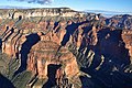
North aspect centered, from Point Imperial
Highest point
Elevation 7,683 ft (2,342 m) [1]
Prominence 463 ft (141 m) [1]
Parent peak Mount Hayden (8,362 ft) [1]
Isolation 0.81 mi (1.30 km) [1]
Coordinates 36°15′42″N111°58′29″W / 36.2617303°N 111.9747936°W / 36.2617303; -111.9747936 Coordinates: 36°15′42″N111°58′29″W / 36.2617303°N 111.9747936°W / 36.2617303; -111.9747936 [2]
Naming
Etymology William A. Hancock
Geography
USA Arizona relief location map.svg
Red triangle with thick white border.svg
Hancock Butte
Location in Arizona
Usa edcp relief location map.png
Red triangle with thick white border.svg
Hancock Butte
Hancock Butte (the United States)
Location Grand Canyon National Park
Coconino County, Arizona, US
Parent range Kaibab Plateau
Colorado Plateau
Topo map USGS Point Imperial
Geology
Age of rock Permian
Climbing
First ascent Alan Doty, October 1976
Easiest route class 5.1 climbing [1]

Hancock Butte is a 7,683-foot-elevation (2,342-meter) summit located in the Grand Canyon, in Coconino County of northern Arizona, US. [2] It is situated one mile south of the Point Imperial viewpoint on the canyon's North Rim, where it towers 3,700 feet (1,100 meters) above Nankoweap Canyon. Its nearest higher neighbor is Mount Hayden, one mile to the north-northeast, Kibbey Butte is one mile to the south-southwest, and Brady Peak is 1.5 mile to the southeast. Hancock Butte is named after William A. Hancock (1831–1902), a pioneer and politician of the Arizona Territory known for performing the survey work required to create the town of Phoenix and erecting the first building there in 1870. [2] This geographical feature's name was officially adopted in 1932 by the U.S. Board on Geographic Names. [2] According to the Köppen climate classification system, Hancock Butte is located in a Cold semi-arid climate zone. [3]

Contents

Geology

Hancock Butte is a butte topped by Esplanade Sandstone, part of the Pennsylvanian-Permian Supai Group overlaying the cliff-forming Mississippian Redwall Limestone. [4] Precipitation runoff from this feature drains east into the Colorado River via Nankoweap Creek.

See also

Related Research Articles

<span class="mw-page-title-main">Mount Hayden (Arizona)</span> Landform in the Grand Canyon, Arizona

Mount Hayden is an 8,362-foot (2,549 m)-elevation summit located in the Grand Canyon, in Coconino County of Arizona, United States. It is situated one-half mile (0.80 km) southeast of the Point Imperial viewpoint, on the canyon's North Rim, where it towers 5,000 feet (1,500 m) above the bottom of Nankoweap Canyon. Mount Hayden, also known as Hayden Peak, is named for Charles T. Hayden (1825–1900), an Arizona pioneer influential in the development of the Arizona Territory where he was known as the "Father of Tempe", and he established Arizona State University. He was also the father of US Senator Carl Hayden, as well as a probate judge. This geographical feature's name was officially adopted in 1932 by the U.S. Board on Geographic Names.

The first ascent of the summit was made May 1978 by Joe Sharber, George Bain, and Abra Watkins via the north side. Pegasus, a challenging class 5.10+ route on the East Face, was first climbed by Paul Davidson and Jim Haisley in 1982. The most popular climbing route is the class 5.8 South Face. According to the Köppen climate classification system, Mount Hayden is located in a Cold semi-arid climate zone.

<span class="mw-page-title-main">Brahma Temple (Grand Canyon)</span> Landform in the Grand Canyon, Arizona

Brahma Temple is a 7,551-foot-elevation summit located in the Grand Canyon, in Coconino County of Arizona, US. It is situated six miles (9.7 km) north-northeast of the Yavapai Point overlook on the canyon's South Rim, and 4.5 miles south of the North Rim's Bright Angel Point. It towers 5,000 feet above Phantom Ranch in Bright Angel Canyon. Its nearest higher neighbor is Oza Butte, four miles to the north-northwest. Other neighbors include Zoroaster Temple one mile to the south, and Deva Temple, 1.5 miles to the north. Brahma Temple is named for Brahma, the Hindu creator of the universe. This name was applied by Clarence Dutton who began the tradition of naming geographical features in the Grand Canyon after mythological deities. This geographical feature's name was officially adopted in 1906 by the U.S. Board on Geographic Names.

<span class="mw-page-title-main">Vishnu Temple (Grand Canyon)</span> Landform in the Grand Canyon, Arizona

Vishnu Temple is a 7,533-foot-elevation (2,296-meter) summit located in the Grand Canyon, in Coconino County of Arizona, US.

<span class="mw-page-title-main">Tower of Set</span> Landform in the Grand Canyon, Arizona

Tower of Set is a 6,012-foot-elevation (1,832-meter) summit located in the Grand Canyon, in Coconino County of Arizona, US. This butte is situated four miles north of Hopi Point overlook on the canyon's South Rim, two miles southeast of Tower of Ra, and three miles south-southwest of Shiva Temple, where it towers 3,600 feet above the Colorado River. Tower of Set was originally named Temple of Sett in 1879 by Thomas Moran, for the Egyptian deity of war, Set, because a niche worn into its wall evoked temples in the valley of the Nile. Another source states it was named by George Wharton James, in keeping with Clarence Dutton's tradition of naming geographical features in the Grand Canyon after mythological deities. This mountain's name was officially adopted in 1906 by the U.S. Board on Geographic Names. In 1919, Harriet Williams Russell Strong proposed connecting Hopi Point and Tower of Set across the river via an aerial tramway, an idea that never came to fruition. The first ascent was made in November 1977 by Bruce Grubbs and Jim Haggart. According to the Köppen climate classification system, Tower of Set is located in a cold semi-arid climate zone.

<span class="mw-page-title-main">Angels Gate</span> Landform in the Grand Canyon, Arizona

Angels Gate is a 6,761-foot (2,061 m)-elevation summit located in the Grand Canyon, in Coconino County of Arizona, United States. It is situated seven miles (11 km) due north of the Grandview Point overlook on the canyon's South Rim, three miles (4.8 km) west of Vishnu Temple, and three point five miles (5.6 km) southeast of Zoroaster Temple. Topographic relief is significant as it rises over 4,200 feet (1,300 m) above the Colorado River in three miles. Angels Gate is the place in Paiute mythology where the gods would return to earth by descending from the shadow world above. George Wharton James applied the "Angel Gate" name to this geographical feature in his book, In & Around the Grand Canyon, in 1900. This feature's name was officially adopted in 1906 by the U.S. Board on Geographic Names. Angels Gate has four peaks composed of Coconino Sandstone. The main highest summit and three spires are known as "Snoopy and his Doghouse" for a resemblance to Snoopy, and the first ascent was made April 1972 by Chuck Graf and Dave Ganci. According to the Köppen climate classification system, Angels Gate is located in a cold semi-arid climate zone.

<span class="mw-page-title-main">Coronado Butte</span> Landform in the Grand Canyon, Arizona

Coronado Butte is a 7,162-foot (2,183 m)-elevation summit located in the Grand Canyon, in Coconino County of Arizona, United States. It is situated one mile (1.6 km) west of the Moran Point overlook on the canyon's South Rim, and one mile northeast of Sinking Ship, its nearest higher neighbor. Topographic relief is significant as this butte rises 4,600 feet (1,400 m) above the Colorado River in 2.5 miles (4.0 km). Coronado Butte is named for Francisco Vázquez de Coronado (1510–1554), the explorer whose 1540 expedition was the first European sighting of the Grand Canyon, among other landmarks. This geographical feature's name was officially adopted in 1906 by the U.S. Board on Geographic Names. The first ascent was made by John Hance and tourist prior to 1900, in the 1890s. According to the Köppen climate classification system, Coronado Butte is located in a cold semi-arid climate zone.

<span class="mw-page-title-main">Apollo Temple</span> Landform in the Grand Canyon, Arizona

Apollo Temple is a 6,252-foot-elevation (1,906-meter) summit located in the Grand Canyon, in Coconino County of northern Arizona, US. It is situated four miles due east of Cape Royal on the canyon's North Rim, four miles northeast of Vishnu Temple, and a half-mile south-southeast of Venus Temple, which is the nearest higher neighbor. Topographic relief is significant as it rises over 3,600 feet above the Colorado River in less than two miles.

<span class="mw-page-title-main">Chuar Butte</span> Landform in the Grand Canyon, Arizona

Chuar Butte is a prominent 6,500-foot-elevation (2,000-meter) summit located in the Grand Canyon, in Coconino County of northern Arizona, US. It is situated 1.5 miles northwest of Cape Solitude on the canyon's East Rim, three miles southeast of Gunther Castle, and immediately west of the confluence of the Colorado River and Little Colorado River. This position also places it where Marble Canyon ends, and the Grand Canyon begins. Topographic relief is significant as it rises nearly 3,800 feet above the river in less than one mile. According to the Köppen climate classification system, Chuar Butte is located in a cold semi-arid climate zone.

<span class="mw-page-title-main">Gunther Castle</span> Landform in the Grand Canyon, Arizona

Gunther Castle is a 7,199-foot-elevation (2,194-meter) summit located in the Grand Canyon, in Coconino County of northern Arizona, US. It is situated three miles northwest of Chuar Butte, between Kwagunt Valley to the north, and Chuar Valley to the south. Topographic relief is significant as it rises nearly 4,500 feet above the Colorado River in three miles.

<span class="mw-page-title-main">Brady Peak</span> Landform in the Grand Canyon, Arizona

Brady Peak is an 8,121-foot (2,475 m)-elevation summit located in the Grand Canyon, in Coconino County of northern Arizona, United States. It is situated one mile (1.6 km) northeast of the Vista Encantada viewpoint on the canyon's North Rim, where it towers 4,800 feet (1,500 m) above the bottom of Nankoweap Canyon. Its nearest higher neighbor is Mount Hayden, two miles (3.2 km) to the north, Kibbey Butte is one mile to northwest, and Alsap Butte lies one mile to the northeast. Brady Peak is named after Peter Rainsford Brady (1825–1902), a pioneer and politician of the Arizona Territory. This geographical feature's name was officially adopted in 1932 by the U.S. Board on Geographic Names. According to the Köppen climate classification system, Brady Peak is located in a cold semi-arid climate zone.

<span class="mw-page-title-main">Diana Temple (Grand Canyon)</span> Landform in the Grand Canyon, Arizona

Diana Temple is a 6,683-foot-elevation (2,037-meter) summit located in the Grand Canyon, in Coconino County of northern Arizona, US. It is situated nine miles northwest of Grand Canyon Village, and immediately northeast of Mescalero Point. Pollux Temple is one mile northwest, Marsh Butte one mile east-northeast, and Vesta Temple is one mile south. Topographic relief is significant as Diana Temple rises nearly 4,300 feet above the Colorado River in less than two miles. Diana Temple is named for Diana, the goddess of the hunt and the moon according to Roman mythology. Clarence Dutton began the practice of naming geographical features in the Grand Canyon after mythological deities. The U.S. Geological Survey applied the name, and this geographical feature's name was officially adopted in 1908 by the U.S. Board on Geographic Names. In the early 1900s this mesa was sometimes called "No Mans Land". According to the Köppen climate classification system, Diana Temple is located in a Cold semi-arid climate zone.

<span class="mw-page-title-main">Marsh Butte</span> Landform in the Grand Canyon, Arizona

Marsh Butte is a 4,721-foot-elevation (1,439-meter) summit located in the Grand Canyon, in Coconino County in the northern part of the U.S. state of Arizona. It is situated eight miles northwest of Grand Canyon Village, immediately east-northeast of Diana Temple, and Tower of Ra stands directly opposite across Granite Gorge. Topographic relief is significant, as Marsh Butte rises over 2,300 feet above the Colorado River in half a mile (1 km).

<span class="mw-page-title-main">Cheops Pyramid</span> Landform in the Grand Canyon, Arizona

Cheops Pyramid is a 5,401-foot-elevation (1,646-meter) summit located in the Grand Canyon, in Coconino County of Arizona, US. This butte is situated four miles north of Grand Canyon Village, 2.5 miles south-southwest of Buddha Temple, and 1.7 mile south-southeast of Isis Temple, which is the nearest higher neighbor. Topographic relief is significant as it rises 3,000 feet above the Colorado River in 1.5 mile. It was named by George Wharton James for the fanciful resemblance to the famous pyramid constructed by Egyptian Pharaoh Cheops. This was in keeping with Clarence Dutton's tradition of naming geographical features in the Grand Canyon after mythological deities. This butte's name was officially adopted in 1906 by the U.S. Board on Geographic Names. According to the Köppen climate classification system, Cheops Pyramid is located in a Cold semi-arid climate zone.

<span class="mw-page-title-main">Geikie Peak</span> Landform in the Grand Canyon, Arizona

Geikie Peak is a 5,005-foot (1,526 m)-elevation summit located in the Grand Canyon, in Coconino County of northern Arizona, United States. It is situated nine miles (14 km) northwest of Grand Canyon Village, immediately north of Diana Temple, and south of Scorpion Ridge which lies across the opposite side of Granite Gorge. Access is via the Tonto Trail which traverses 270 degrees around the base of the peak. Topographic relief is significant as Geikie Peak rises over 2,600 feet (790 m) above the Colorado River in one-half mile (0.80 km). According to the Köppen climate classification system, Geikie Peak is located in a cold semi-arid climate zone.

<span class="mw-page-title-main">Newberry Butte</span> Landform in the Grand Canyon, Arizona

Newberry Butte is a 5,105-foot-elevation (1,556-meter) summit located in the Grand Canyon, in Coconino County of northern Arizona, US. It is situated 4.5 miles north of the South Rim's Grandview Point, three miles southwest of Vishnu Temple, and 2.5 miles south of Wotans Throne. Topographic relief is significant as it rises over 2,500 feet above the Colorado River and Granite Gorge in one mile. According to the Köppen climate classification system, Newberry Butte is located in a Cold semi-arid climate zone.

<span class="mw-page-title-main">Solomon Temple (Grand Canyon)</span> Landform in the Grand Canyon, Arizona

Solomon Temple is a 5,121-foot-elevation (1,561-meter) summit located in the Grand Canyon, in Coconino County of northern Arizona, USA. It is situated four miles north of Moran Point, 3.5 miles east of Newberry Butte, and 1.5 mile southeast of Rama Shrine, its nearest higher neighbor. Topographic relief is significant as it rises 2,500 feet above the Colorado River in less than one mile.

<span class="mw-page-title-main">Alsap Butte</span> Rock formation in the Grand Canyon, Arizona, United States

Alsap Butte is a 7,494-foot-elevation (2,284-meter) summit located in the Grand Canyon in Coconino County of northern Arizona, USA. It is situated two miles north of the Roosevelt Point on the canyon's North Rim, where it towers 3,700 feet above Nankoweap Canyon. Its nearest higher neighbor is Brady Peak, one mile to the southwest, with Hancock Butte and Mount Hayden set to the northwest, and Colter Butte two miles to southeast. Alsap Butte is named after John T. Alsap, a pioneer and politician of the Arizona Territory who served as the first mayor of Phoenix, and is known as "Father of Maricopa County". The geographical feature's name was officially adopted in 1932 by the United States Board on Geographic Names. According to the Köppen climate classification system, Alsap Butte is located in a cold semi-arid climate zone. Alsap Butte is composed of Pennsylvanian-Permian Supai Group overlaying cliff-forming Mississippian Redwall Limestone, which in turn overlays slope-forming Cambrian Tonto Group. Precipitation runoff from this feature drains northeast into the Colorado River via Nankoweap Creek.

<span class="mw-page-title-main">Butchart Butte</span> Landform in the Grand Canyon, Arizona

Butchart Butte is a 7,602-foot (2,317 m)-elevation summit located in the Grand Canyon, in Coconino County of northern Arizona, United States. It is situated on the North Rim, midway between Gunther Castle and Siegfried Pyre, and between the Chuar and Kwagunt Valleys. Topographic relief is significant as it rises 4,900 feet (1,500 m) above the Colorado River in five miles.

<span class="mw-page-title-main">Kibbey Butte</span> Landform in the Grand Canyon, Arizona

Kibbey Butte is a 7,801-foot-elevation (2,378-meter) summit located in the Grand Canyon, in Coconino County of northern Arizona, US. It is situated two miles south of the Point Imperial viewpoint on the canyon's North Rim, where it towers over 3,000 feet above Nankoweap Canyon. Its nearest higher neighbor is Brady Peak one mile to the southeast, Hancock Butte is one mile to the north-northeast, and Alsap Butte is two miles to the east. The summit of this butte is composed of dark reddish Permian Hermit Shale overlaying the Pennsylvanian-Permian Supai Group, in turn overlaying the cliff-forming Mississippian Redwall Limestone. According to the Köppen climate classification system, Kibbey Butte is located in a cold semi-arid climate zone. Precipitation runoff from this feature drains east into the Colorado River via Nankoweap Creek. Cross-country access to Kibbey Butte starts at the parking area for Greenland Lake. The first ascent of the summit was made by Harvey Butchart and Allyn Cureton on May 31, 1961.

<span class="mw-page-title-main">Colter Butte</span> Landform in the Grand Canyon, Arizona

Colter Butte is a 7,254-foot-elevation (2,211-meter) summit located in the Grand Canyon in Coconino County of northern Arizona, US. It is situated four miles southeast of Point Imperial, where it towers 3,600 feet above Nankoweap Canyon. Its neighbors include Brady Peak, 2.5 miles to the west-northwest, Alsap Butte two miles to the northwest, and Swilling Butte one-half mile to the east. Colter Butte is named after James G. H. Colter (1844–1922), born in Nova Scotia, Canada, he came to the Arizona Territory in 1872 as a pioneer, farmer, cattleman, Apache and desperado fighter. He was the father of Arizona state senator Fred Colter. This geographical feature's name was officially adopted in 1932 by the United States Board on Geographic Names. According to the Köppen climate classification system, Colter Butte is located in a cold semi-arid climate zone. This butte is composed of Pennsylvanian-Permian Supai Group which overlays cliff-forming Mississippian Redwall Limestone, which in turn overlays slope-forming Cambrian Tonto Group. Precipitation runoff from this feature drains east to the Colorado River via Nankoweap Creek on the north side and Kwagunt Creek from the south slope.

References

  1. 1 2 3 4 5 "Hancock Butte – 7,683' AZ". Lists of John. Retrieved 2021-01-24.
  2. 1 2 3 4 "Hancock Butte". Geographic Names Information System . United States Geological Survey, United States Department of the Interior . Retrieved 2021-01-24.
  3. Peel, M. C.; Finlayson, B. L.; McMahon, T. A. (2007). "Updated world map of the Köppen−Geiger climate classification". Hydrol. Earth Syst. Sci. 11. ISSN   1027-5606.
  4. William Kenneth Hamblin, Anatomy of the Grand Canyon: Panoramas of the Canyon's Geology, 2008, Grand Canyon Association Publisher, ISBN   9781934656013.