Hidalgo County | |
|---|---|
 Hidalgo County courthouse in Lordsburg | |
 Location within the U.S. state of New Mexico | |
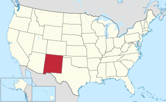 New Mexico's location within the U.S. | |
| Coordinates: 31°55′N108°43′W / 31.92°N 108.71°W | |
| Country | |
| State | |
| Founded | January 1, 1920 |
| Named after | Villa de Guadalupe Hidalgo |
| Seat | Lordsburg |
| Largest city | Lordsburg |
| Area | |
• Total | 3,446 sq mi (8,930 km2) |
| • Land | 3,437 sq mi (8,900 km2) |
| • Water | 9.1 sq mi (24 km2) 0.3% |
| Population (2020) | |
• Total | 4,178 |
| • Density | 1.216/sq mi (0.4693/km2) |
| Time zone | UTC−7 (Mountain) |
| • Summer (DST) | UTC−6 (MDT) |
| Congressional district | 2nd |
| Website | www |
Hidalgo County (Spanish : Condado de Hidalgo) is the southernmost county of the U.S. state of New Mexico. As of the 2020 census, the population was 4,178. [1] The county seat and largest city is Lordsburg. [2] A bill creating Hidalgo from the southern part of Grant County was passed on February 25, 1919, taking effect at the beginning of 1920. [3] [4] The county was named for the town north of Mexico City where the Treaty of Guadalupe Hidalgo was signed, [5] which in turn was named for Miguel Hidalgo y Costilla, the priest who is known as the "Father of Mexican Independence."
Contents
- Geography
- Adjacent counties and municipios
- National protected areas
- Demographics
- 2000 census
- 2010 census
- Communities
- City
- Village
- Census-designated places
- Unincorporated communities
- Ghost towns
- Politics
- See also
- References
- External links
The county is located on the Mexico–United States border, comprises the New Mexico Bootheel, and is majority-Hispanic or Latino.
