Kankakee County, Illinois

Last updated

Kankakee County
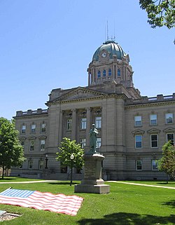
Kankakee County Courthouse.jpg
Map of Illinois highlighting Kankakee County.svg
Location within the U.S. state of Illinois
Illinois in United States.svg
Illinois's location within the U.S.
Coordinates: 41°08′N87°52′W / 41.14°N 87.86°W / 41.14; -87.86
CountryFlag of the United States.svg United States
StateFlag of Illinois.svg  Illinois
FoundedFebruary 11, 1853
Named for Kankakee River
Seat Kankakee
Largest cityKankakee
Area
  Total
681 sq mi (1,760 km2)
  Land677 sq mi (1,750 km2)
  Water4.8 sq mi (12 km2)  0.7%
Population
 (2020)
  Total
107,502
  Density160/sq mi (61/km2)
Time zone UTC−6 (Central)
  Summer (DST) UTC−5 (CDT)
Congressional districts 1st, 2nd
Website www.co.kankakee.il.us

Kankakee County is a county located in the U.S. state of Illinois. According to the 2020 census, it has a population of 107,502. [1] Its county seat is Kankakee. [2] Kankakee County comprises the Kankakee, IL Metropolitan Statistical Area.

Contents

History

Starting in the 1770s, if not earlier, the area that is now Kankakee County was largely populated by the Potawatomi.

French Canadian Settlers came to Kankakee County in 1834, after the federal government signed the Treaty of Camp Tippecanoe in 1832. They were soon joined by migrants from New York and Vermont, mostly locating in Momence, Illinois. In the 1840s, most of the migrants were French Canadians, and they settled in such places as Bourbonnais.

An act of the Illinois Legislature created Kankakee County out of the north part of Iroquois County and the south part of Will County in February 1853. The six original townships were Yellowhead, Rockville, Bourbonnais, Momence, Aroma Park, and Limestone. The population of the new county was about 8,000. In 1855 the two western townships (Norton and Essex) were taken from Vermilion County and added to Kankakee County. The county was named for the Kankakee River.

Geography

According to the U.S. Census Bureau, the county has a total area of 681 square miles (1,760 km2), of which 677 square miles (1,750 km2) (99.3%) is land and 4.8 square miles (12 km2) (0.7%) is water. [3]

Climate and weather

Kankakee, Illinois
Climate chart (explanation)
J
F
M
A
M
J
J
A
S
O
N
D
 
 
1.8
 
 
31
12
 
 
1.6
 
 
37
17
 
 
2.8
 
 
48
28
 
 
3.8
 
 
61
38
 
 
4.5
 
 
73
49
 
 
4.4
 
 
83
59
 
 
4.4
 
 
86
63
 
 
3.1
 
 
84
61
 
 
3.5
 
 
78
52
 
 
2.7
 
 
65
40
 
 
3.4
 
 
50
30
 
 
2.6
 
 
36
19
Average max. and min. temperatures in °F
Precipitation totals in inches
Source: The Weather Channel [4]
Metric conversion
J
F
M
A
M
J
J
A
S
O
N
D
 
 
45
 
 
−1
−11
 
 
41
 
 
3
−8
 
 
71
 
 
9
−2
 
 
97
 
 
16
3
 
 
115
 
 
23
9
 
 
113
 
 
28
15
 
 
111
 
 
30
17
 
 
79
 
 
29
16
 
 
88
 
 
26
11
 
 
69
 
 
18
4
 
 
85
 
 
10
−1
 
 
66
 
 
2
−7
Average max. and min. temperatures in °C
Precipitation totals in mm

In recent years, average temperatures in the county seat of Kankakee have ranged from a low of 12 °F (−11 °C) in January to a high of 86 °F (30 °C) in July, although a record low of −29 °F (−34 °C) was recorded in January 1985 and a record high of 107 °F (42 °C) was recorded in August 1988. Average monthly precipitation ranged from 1.62 inches (41 mm) in February to 4.54 inches (115 mm) in May. [4]

Adjacent counties

Demographics

Historical population
CensusPop.Note
1860 15,412
1870 24,35258.0%
1880 25,0472.9%
1890 28,73214.7%
1900 37,15429.3%
1910 40,7529.7%
1920 44,92010.2%
1930 50,09511.5%
1940 60,87721.5%
1950 73,52420.8%
1960 92,06325.2%
1970 97,2505.6%
1980 102,9265.8%
1990 96,255−6.5%
2000 103,8337.9%
2010 113,4499.3%
2020 107,502−5.2%
2023 (est.)105,940 [5] −1.5%
U.S. Decennial Census [6]
1790-1960 [7] 1900-1990 [8]
1990-2000 [9] 2010 [10]
2000 census age pyramid for Kankakee County USA Kankakee County, Illinois age pyramid.svg
2000 census age pyramid for Kankakee County

As of the 2010 United States census, there were 113,449 people, 41,511 households, and 28,680 families residing in the county. [11] The population density was 167.7 inhabitants per square mile (64.7/km2). There were 45,246 housing units at an average density of 66.9 per square mile (25.8/km2). [3] The racial makeup of the county was 77.6% white, 15.1% black or African American, 0.9% Asian, 0.3% Native American, 4.0% from other races, and 2.1% from two or more races. Those of Hispanic or Latino origin made up 9.0% of the population. [11] In terms of ancestry, 26.5% were German, 14.2% were Irish, 7.4% were English, 6.7% were Italian, 5.8% were Polish, and 3.6% were American. [12]

Of the 41,511 households, 35.2% had children under the age of 18 living with them, 49.1% were married couples living together, 14.7% had a female householder with no husband present, 30.9% were non-families, and 25.5% of all households were made up of individuals. The average household size was 2.61 and the average family size was 3.13. The median age was 36.7 years. [11]

The median income for a household in the county was $50,484 and the median income for a family was $59,998. Males had a median income of $49,858 versus $32,247 for females. The per capita income for the county was $22,888. About 10.8% of families and 15.0% of the population were below the poverty line, including 20.6% of those under age 18 and 8.4% of those age 65 or over. [13]

Communities

Cities

Villages

Unincorporated Communities

Townships

Kankakee County is divided into seventeen townships:

Politics

United States presidential election results for Kankakee County, Illinois [14]
Year Republican Democratic Third party(ies)
No.%No.%No.%
2024 28,28559.19%18,39938.50%1,1012.30%
2020 28,53257.02%20,27140.51%1,2372.47%
2016 25,12953.12%18,97140.10%3,2056.78%
2012 23,13650.68%21,59547.30%9232.02%
2008 22,52746.80%24,75051.41%8611.79%
2004 24,73954.93%20,00344.42%2940.65%
2000 20,04949.89%19,18047.73%9542.37%
1996 14,59541.41%16,82047.73%3,82610.86%
1992 15,41138.46%17,22943.00%7,43118.54%
1988 20,31656.82%15,14742.36%2920.82%
1984 23,80760.02%15,24638.44%6121.54%
1980 23,81058.25%14,62635.78%2,4375.96%
1976 23,00354.63%18,39443.68%7111.69%
1972 26,86666.54%13,43433.27%730.18%
1968 20,02552.35%14,46037.80%3,7659.84%
1964 16,08243.61%20,79256.39%00.00%
1960 20,31154.23%17,11545.70%260.07%
1956 21,99366.39%11,08833.47%470.14%
1952 20,27961.44%12,63638.29%900.27%
1948 15,69957.71%11,30541.56%1970.72%
1944 15,25657.16%11,34242.50%900.34%
1940 15,99853.62%13,71645.97%1240.42%
1936 10,93541.21%13,16249.60%2,4419.20%
1932 10,87343.86%13,55554.67%3641.47%
1928 11,90553.44%10,24745.99%1270.57%
1924 12,46267.47%2,48813.47%3,52119.06%
1920 12,85379.33%2,82817.46%5203.21%
1916 10,59462.28%6,09635.84%3191.88%
1912 3,17836.41%2,53229.01%3,01834.58%
1908 5,99968.46%2,46128.08%3033.46%
1904 6,16274.93%1,65220.09%4104.99%
1900 5,79867.44%2,67431.10%1251.45%
1896 5,47168.20%2,37029.54%1812.26%
1892 3,57754.42%2,76342.04%2333.54%

Kankakee County is currently considered a Republican-leaning swing county. In the 2008 Presidential Election, Kankakee County voted 52 percent in favor of Illinois native Barack Obama (D), giving 47 percent to John McCain (R). However, in the 2004 Presidential Election, Kankakee County voted 55 percent in favor of George W. Bush (R) and 44 percent for John Kerry (D).

Kankakee County is split between Illinois's 2nd congressional district, represented by Democrat Robin Kelly (D-Matteson), and Illinois's 1st congressional district, represented by Jonathan Jackson (D-Chicago). Kankakee County has produced three governors: Len Small (R), Samuel H. Shapiro (D), and George H. Ryan (R).

In December 2016, Kankakee County became the only county in Illinois to have a Libertarian county board member when Jim Byrne of Bradley left the Republican Party to join the Libertarian Party. [15] In the 2020 general election, Byrne lost reelection to Democratic candidate Heather Bryan, while Libertarian Jacob Collins was elected unopposed on the Libertarian line continuing Kankakee County's distinction of being the only county with a Libertarian board member [16] [17] until Collins opted not to run for reelection in the 2022 general election. [18]

Education

The county is home to Olivet Nazarene University and Kankakee Community College.

Transportation

Kankakee County is served by the Greater Kankakee Airport. Amtrak runs train service through the city via Kankakee station. The station serves the Illini and Saluki trains to Carbondale as well as the City of New Orleans . The city of Kankakee has local public transit service provided by the River Valley Metro Mass Transit District. Momence and rural Kankakee county are served by SHOW Bus.

Major highways

See also

Related Research Articles

<span class="mw-page-title-main">Will County, Illinois</span> County in Illinois, United States

Will County is a county in the northeastern part of the state of Illinois. According to the 2020 census, it had a population of 696,355, an increase of 2.8% from 677,560 in 2010, making it Illinois's fourth-most populous county. The county seat is Joliet. Will County is one of the five collar counties of the Chicago–Naperville–Elgin, IL–IN–WI Metropolitan Statistical Area. The portion of Will County around Joliet uses area codes 815 and 779, while 630 and 331 are for far northern Will County and 708 is for central and eastern Will County.

<span class="mw-page-title-main">Iroquois County, Illinois</span> County in Illinois, United States

Iroquois County is a county located in the northeast part of the U.S. state of Illinois. According to the 2020 United States Census, it has a population of 27,077. It is the only county in the United States named Iroquois. The county seat is Watseka. The county is located along the border with Indiana.

<span class="mw-page-title-main">Ford County, Illinois</span> County in Illinois, United States

Ford County is a county located in the U.S. state of Illinois. According to the 2020 United States Census, it had a population of 13,534. Its county seat is Paxton. Ford County was part of the Champaign–Urbana, IL Metropolitan Statistical Area until 2018, when the Office of Management and Budget removed the county from the area.

<span class="mw-page-title-main">Aroma Park, Illinois</span> Village in Illinois, United States

Aroma Park is a village in Kankakee County, Illinois, United States, along the Kankakee River opposite the mouth of the Iroquois River. Aroma Park is a suburb of the city of Kankakee. Aroma Park's population was 743 at the 2010 census, down from 821 at the 2000 census. It is included in the Kankakee-Bradley, Illinois Metropolitan Statistical Area.

<span class="mw-page-title-main">Bourbonnais, Illinois</span> Village in Illinois, United States

Bourbonnais is a village in Kankakee County, Illinois, United States. The population was 18,164 at the 2020 census.

<span class="mw-page-title-main">Bradley, Illinois</span> Village in Illinois, United States

Bradley is a village in Kankakee County, Illinois, United States. It is a suburb of the city of Kankakee. The population was 15,895 at the 2010 census, up from 12,784 at the 2000 census.

<span class="mw-page-title-main">Hopkins Park, Illinois</span> Village in Illinois, United States

Hopkins Park is a village in Kankakee County, Illinois, United States. The population was 603 at the 2010 census, down from 711 at the 2000 census. It is part of the Kankakee–Bradley Metropolitan Statistical Area.

<span class="mw-page-title-main">Kankakee, Illinois</span> City in Illinois, United States

Kankakee is a city in and the county seat of Kankakee County, Illinois, United States. Located on the Kankakee River, as of 2020, the city's population was 24,052. Kankakee is a principal city of the Kankakee-Bourbonnais-Bradley Metropolitan Statistical Area. It serves as an anchor city in the rural plains outside Chicago.

<span class="mw-page-title-main">Manteno, Illinois</span> Village in Illinois, United States

Manteno is a village in Kankakee County, Illinois, United States. The population was 9,210 at the 2020 census. It is part of the Kankakee-Bourbonnais-Bradley Metropolitan Statistical Area.

<span class="mw-page-title-main">Momence, Illinois</span> City in Illinois, United States

Momence is a city in Momence Township, Kankakee County, Illinois, United States. The population was 3,171 at the 2000 census, and 3,310 in 2010. It is part of the Kankakee–Bradley Metropolitan Statistical Area.

<span class="mw-page-title-main">St. Anne, Illinois</span> Village in Illinois, United States

St. Anne is a village in Kankakee County, Illinois, United States. The population was 1,161 at the 2020 census. It is part of the Kankakee–Bourbonnais–Bradley Metropolitan Statistical Area. It was founded in 1851 by Charles Chiniquy, a French-Canadian Catholic priest and friend of the 16th U.S. President Abraham Lincoln who was excommunicated by the Catholic Church in 1856. He later converted to Protestant Christianity, becoming a Presbyterian Evangelical minister and a well-known temperance activist in Canada and the United States.

<span class="mw-page-title-main">Sun River Terrace, Illinois</span> Village in Illinois, United States

Sun River Terrace is a village in Kankakee County, Illinois, United States. The population was 455 at the 2020 census. It is included in the Kankakee-Bradley, Illinois Metropolitan Statistical Area.

<span class="mw-page-title-main">Aroma Township, Kankakee County, Illinois</span> Township in Illinois, United States

Aroma Township is one of seventeen townships in Kankakee County, Illinois, USA. As of the 2010 census, its population was 5,157 and it contained 2,203 housing units.

<span class="mw-page-title-main">Bourbonnais Township, Kankakee County, Illinois</span> Township in Illinois, United States

Bourbonnais Township is one of seventeen townships in Kankakee County, Illinois, USA. As of the 2010 census, its population was 40,137 and it contained 15,153 housing units.

<span class="mw-page-title-main">Ganeer Township, Kankakee County, Illinois</span> Township in Illinois, United States

Ganeer Township is one of seventeen townships in Kankakee County, Illinois, USA. As of the 2010 census, its population was 3,215 and it contained 1,411 housing units.

<span class="mw-page-title-main">Kankakee Township, Kankakee County, Illinois</span> Township in Illinois, United States

Kankakee Township is one of seventeen townships in Kankakee County, Illinois, United States. As of the 2010 census, its population was 27,558 and it contained 11,219 housing units. This township has the smallest area in the county, but is second largest in population.

<span class="mw-page-title-main">Manteno Township, Kankakee County, Illinois</span> Township in Illinois, United States

Manteno Township is one of seventeen townships in Kankakee County, Illinois, USA. As of the 2010 census, its population was 11,185 and it contained 4,525 housing units. It was formed from Rockville Township on March 12, 1855.

<span class="mw-page-title-main">Rockville Township, Kankakee County, Illinois</span> Township in Illinois, United States

Rockville Township is one of seventeen townships in Kankakee County, Illinois, USA. As of the 2010 census, its population was 879 and it contained 326 housing units. It was formerly a township of Will County until Kankakee County was created. The township's name may have been derived from a Potawatomi village known to the pioneers as "Little Rock Village."

<span class="mw-page-title-main">Sumner Township, Kankakee County, Illinois</span> Township in Illinois, United States

Sumner Township is one of seventeen townships in Kankakee County, Illinois, USA. As of the 2010 census, its population was 910 and it contained 337 housing units. It was formed as Union Township from part of Yellow Head Township on October 8, 1855; its name changed to Sumner Township on June 27, 1856.

<span class="mw-page-title-main">River Valley Metro Mass Transit District</span>

The River Valley Metro Mass Transit District is a transit agency that operates buses serving Kankakee County, Illinois, and the surrounding areas.

References

Specific
  1. "Kankakee County, Illinois". United States Census Bureau . Retrieved June 9, 2023.
  2. "Find a County". National Association of Counties. Archived from the original on May 31, 2011. Retrieved June 7, 2011.
  3. 1 2 "Population, Housing Units, Area, and Density: 2010 - County". United States Census Bureau. Archived from the original on February 12, 2020. Retrieved July 12, 2015.
  4. 1 2 "Monthly Averages for Kankakee, Illinois". The Weather Channel. Archived from the original on September 1, 2010. Retrieved January 27, 2011.
  5. "Annual Estimates of the Resident Population for Counties: April 1, 2020 to July 1, 2023". United States Census Bureau. Retrieved April 2, 2024.
  6. "U.S. Decennial Census". United States Census Bureau. Retrieved July 6, 2014.
  7. "Historical Census Browser". University of Virginia Library. Archived from the original on August 11, 2012. Retrieved July 6, 2014.
  8. "Population of Counties by Decennial Census: 1900 to 1990". United States Census Bureau. Archived from the original on April 24, 2014. Retrieved July 6, 2014.
  9. "Census 2000 PHC-T-4. Ranking Tables for Counties: 1990 and 2000" (PDF). United States Census Bureau. Archived (PDF) from the original on December 18, 2014. Retrieved July 6, 2014.
  10. "State & County QuickFacts". United States Census Bureau. Archived from the original on June 6, 2011. Retrieved July 6, 2014.
  11. 1 2 3 "Profile of General Population and Housing Characteristics: 2010 Demographic Profile Data". United States Census Bureau. Archived from the original on February 13, 2020. Retrieved July 12, 2015.
  12. "Selected Social Characteristics in the United States – 2006-2010 American Community Survey 5-Year Estimates". United States Census Bureau. Archived from the original on February 13, 2020. Retrieved July 12, 2015.
  13. "Selected Economic Characteristics – 2006-2010 American Community Survey 5-Year Estimates". United States Census Bureau. Archived from the original on February 13, 2020. Retrieved July 12, 2015.
  14. Leip, David. "Dave Leip's Atlas of U.S. Presidential Elections". uselectionatlas.org. Archived from the original on March 23, 2018. Retrieved May 6, 2018.
  15. "Kankakee County Board's Byrne Joins Libertarian Party of Illinois" (Press release). Springfield, Illinois: Libertarian Party of Illinois. December 7, 2016. Archived from the original on April 18, 2017. Retrieved April 18, 2017.
  16. Winger, Richard (November 22, 2020). "Libertarian Party Won Four Partisan Races Earlier This Month". Ballot Access News . Archived from the original on November 22, 2020. Retrieved October 6, 2022.
  17. Breach, Chris (November 4, 2020). "Kankakee County Board District 23". Daily Journal. Archived from the original on November 4, 2020.
  18. Breach, Chris (November 9, 2023). "Republicans sweep other 5 contested Kankakee County Board seats". Daily Journal . Archived from the original on November 9, 2022. Retrieved July 14, 2023.
General

41°08′N87°52′W / 41.14°N 87.86°W / 41.14; -87.86