Kansas's 2nd congressional district | |||
---|---|---|---|
Representative |
| ||
Distribution |
| ||
Population (2022) | 730,784 | ||
Median household income | $60,983 [1] | ||
Ethnicity |
| ||
Cook PVI | R+11 [2] |
Kansas' 2nd congressional district is a congressional district in the U.S. state of Kansas that covers most of the eastern part of the state, except for the core of the Kansas City Metropolitan Area. The district encompasses less than a quarter of the state. The state capital of Topeka, the cities of Emporia, Junction City and Leavenworth and most of Kansas City are located within this district. The district is currently represented by Republican Jake LaTurner.
Kansas had but one representative in the U.S. House of Representatives until after the 1870 U.S. census, which showed that the state was entitled to three members of the lower branch of the national legislature. In 1872, three representatives-at-large were elected, but by the act of March 2, 1874, the legislature divided the state into three districts. The 2nd congressional district was composed of the counties of Montgomery, Wilson, Labette, Cherokee, Crawford, Neosho, Bourbon, Allen, Anderson, Linn, Miami, Franklin, Johnson, Douglas and Wyandotte.
No changes were made in until after the 1880 U.S. census, which gave the state seven representatives. On March 5, 1883, Governor George Washington Glick approved an act of the legislature which reduced the 2nd congressional district to only include the counties of Wyandotte, Johnson, Douglas, Miami, Franklin, Anderson, Linn, Allen and Bourbon.
Although the 1890 U.S. census showed the population of Kansas to be large enough to entitle the state to eight representatives, no additional district was created until 1905. By the act of March 9, 1905, the state was divided into eight districts with the 2nd Congressional district being composed of the counties of Wyandotte, Johnson, Douglas, Miami, Franklin, Anderson, Linn, Allen and Bourbon. [3]
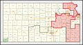
Reapportionment for 2002 placed the western half of Lawrence as well as Miami County into the 2nd congressional district and cut out the counties of Geary, Montgomery and Nemaha.
Reapportionment in 2012 meant that the entirety of Lawrence was moved to the 2nd congressional district. The district's boundaries were altered to remove Manhattan, home of Kansas State University, and portions of Miami County while adding all of Montgomery County and Nemaha County and portions of Marshall County.
Reapportionment in 2022 moved the entirety of Lawrence to the 1st congressional district. The district's boundaries were also altered to move Anderson and Franklin counties and portions of Miami County to the 3rd congressional district. The entirety of Miami County is now in the 3rd congressional district. Most of Jackson, all of Jefferson and the remaining part of Marshall counties moved from the district to the 1st congressional district. The counties of Chase, Geary, Lyon, Marion, Morris and Wabaunsee all moved from the 1st congressional district to the district.
Following redistricting after the 2000 U.S. census, [4] there were 672,102 people, 257,856 households, and 173,309 families residing in the district. The population density was 47.6/mi2 over a land area of 14,133 square miles (36,600 km2). There were 280,213 housing units at an average density of 19.8/mi2. The racial makeup of the district is 89.01% White, 5.06% Black or African American, 1.26% Native American, 0.97% Asian, 0.06% Pacific Islander, 1.52% from other races, and 2.12% from two or more races. Hispanic or Latino of any race were 3.81% of the population.
There were 257,856 households, out of which 34.60% had children under the age of 18 living with them, 54.48% were married couples living together, 9.20% had a female householder with no husband present, and 32.79% were non-families. 26.73% of all households were made up of individuals, and 10.63% had someone living alone who was 65 years of age or older. The average household size was 2.49 and the average family size was 3.02.
In the district the population distribution by age is 25.34% under the age of 18, 11.88% from 18 to 24, 27.54% from 25 to 44, 21.70% from 45 to 64, and 13.54% who were 65 years of age or older. The median age was 35.3 years. For every 100 females, there were 99.08 males. For every 100 females age 18 and over, there were 96.85 males.
The median income for a household in the district is $37,855, and the median income for a family was $47,095. Males had a median income of $32,033 versus $24,230 for females. The per capita income for the district was $18,595. About 7.1% of families and 11.2% of the population were below the poverty line, including 12.0% of those under age 18 and 9.3% of those age 65 or over.
Among the population aged 16 years and older, 64.5% was in the civilian labor force and 1.9% were in the armed forces. Of the employed civilian workers, 20.6% were government workers and 7.5% were self-employed. Management, professional, and related occupations employed 32.3% of the work force and sales and office occupations employ 25.4%. Only 0.8% were employed in farming, fishing, and forestry occupations. The largest employment by industry was: educational, health and social services, 24.5%; manufacturing, 12.3%; and retail trade, 11.4%. Agriculture, forestry, fishing and hunting, and mining industries only employed 3.0%.
Year | Office | Results |
---|---|---|
2000 | U.S. President | George W. Bush (R) 54% – Al Gore (D) 41% |
2004 | U.S. President | George W. Bush (R) 60% – John Kerry (D) 39% |
2008 | U.S. President | John McCain (R) 55% – Barack Obama (D) 43% |
2012 | U.S. President | Mitt Romney (R) 56% – Barack Obama (D) 42% |
2016 | U.S. President | Donald Trump (R) 56% – Hillary Clinton (D) 37% |
2020 | U.S. President | Donald Trump (R) 56% – Joe Biden (D) 41% |
Party | Candidate | Votes | % | |
---|---|---|---|---|
Republican | Jim Ryun* | 126,169 | 60.45 | |
Democratic | Dan Lykins | 78,286 | 37.51 | |
Libertarian | Art Clack | 4,263 | 2.04 | |
Total votes | 208,718 | 100.00 | ||
Republican hold | ||||
Party | Candidate | Votes | % | |
---|---|---|---|---|
Republican | Jim Ryun* | 165,325 | 56.15 | |
Democratic | Nancy Boyda | 121,532 | 41.28 | |
Libertarian | Dennis Hawver | 7,579 | 2.57 | |
Total votes | 294,436 | 100.00 | ||
Republican hold | ||||
Party | Candidate | Votes | % | |||
---|---|---|---|---|---|---|
Democratic | Nancy Boyda | 111,759 | 50.60 | |||
Republican | Jim Ryun* | 104,128 | 47.15 | |||
Reform | Roger Tucker | 4,980 | 2.26 | |||
Total votes | 220,867 | 100.00 | ||||
Democratic gain from Republican | ||||||
Party | Candidate | Votes | % | |||
---|---|---|---|---|---|---|
Republican | Lynn Jenkins | 155,532 | 50.61 | |||
Democratic | Nancy Boyda* | 142,013 | 46.21 | |||
Reform | Leslie Martin | 5,080 | 1.65 | |||
Libertarian | Robert Garrard | 4,683 | 1.52 | |||
Total votes | 262,027 | 100.00 | ||||
Republican gain from Democratic | ||||||
Party | Candidate | Votes | % | |
---|---|---|---|---|
Republican | Lynn Jenkins* | 130,034 | 63.13 | |
Democratic | Cheryl Hudspeth | 66,588 | 32.33 | |
Libertarian | Robert Garrard | 9,353 | 4.54 | |
Total votes | 205,975 | 100.00 | ||
Republican hold | ||||
Party | Candidate | Votes | % | |
---|---|---|---|---|
Republican | Lynn Jenkins* | 167,463 | 57.0 | |
Democratic | Tobias Schlingensiepen | 113,735 | 38.7 | |
Libertarian | Dennis Hawver | 12,520 | 4.2 | |
Total votes | 293,718 | 100.00 | ||
Republican hold | ||||
Party | Candidate | Votes | % | |
---|---|---|---|---|
Republican | Lynn Jenkins* | 128,742 | 57.0 | |
Democratic | Margie Wakefield | 87,153 | 38.6 | |
Libertarian | Christopher Clemmons | 9,791 | 4.3 | |
Total votes | 225,686 | 99.9 | ||
Republican hold | ||||
Party | Candidate | Votes | % | |
---|---|---|---|---|
Republican | Lynn Jenkins* | 181,228 | 60.9 | |
Democratic | Britani Potter | 96,840 | 32.5 | |
Libertarian | James Houston Bales | 19,333 | 6.5 | |
Total votes | 297,401 | 99.9 | ||
Republican hold | ||||
Party | Candidate | Votes | % | |
---|---|---|---|---|
Republican | Steve Watkins | 126,098 | 47.6 | |
Democratic | Paul Davis | 123,859 | 46.8 | |
Libertarian | Kelly Standley | 14,731 | 5.6 | |
Total votes | 264,688 | 100 | ||
Republican hold | ||||
Party | Candidate | Votes | % | |
---|---|---|---|---|
Republican | Jake LaTurner | 185,464 | 55.2 | |
Democratic | Michelle De La Isla | 136,650 | 40.6 | |
Libertarian | Robert Garrard | 14,201 | 4.2 | |
Total votes | 336,315 | 100.0 | ||
Republican hold | ||||
Party | Candidate | Votes | % | |
---|---|---|---|---|
Republican | Jake LaTurner (incumbent) | 134,506 | 57.6 | |
Democratic | Patrick Schmidt | 98,852 | 42.4 | |
Total votes | 233,358 | 100.0 | ||
Republican hold | ||||
Ottawa County is a county located in the northeastern corner of the U.S. state of Oklahoma. As of the 2020 census, the population was 30,285. Its county seat is Miami. The county was named for the Ottawa Tribe of Oklahoma. It is also the location of the federally recognized Modoc Nation and the Quapaw Nation, which is based in Quapaw.
Nemaha County is a county in the U.S. state of Nebraska. As of the 2020 United States Census, the population was 7,074. Its county seat is Auburn.
Vernon County is located in the western region of the U.S. state of Missouri, on the border with Kansas. As of the 2020 census, the population was 19,707. Its county seat is Nevada. The county was organized on February 27, 1855, considerably later than counties in the eastern part of the state. It was named for Colonel Miles Vernon (1786–1867), a state senator and veteran of the Battle of New Orleans. This area was part of the large historic territory of the Osage Nation of Native Americans.
Wyandotte County is a county in the U.S. state of Kansas. Its county seat and most populous city is Kansas City, with which it shares a unified government. As of the 2020 census, the population was 169,245, making it Kansas's fourth-most populous county. The county was named after the Wyandot tribe.
Nemaha County is a county located in the northeastern part of the U.S. state of Kansas. Its county seat is Seneca. As of the 2020 census, the county population was 10,273. The county was named for the Nemaha River.
Marshall County is a county located in the U.S. state of Kansas. Its county seat and largest city is Marysville. As of the 2020 census, the county population was 10,038. The county was named after Frank J. Marshall, a state representative who operated the first ferry over the Big Blue River.
Linn County is a county in the U.S. state of Kansas, located in along the eastern edge of Kansas, and is part of the Kansas City metropolitan area. Its county seat is Mound City, and its most populous city is Pleasanton. As of the 2020 census, the county population was 9,591. The county was named for Lewis Linn, a U.S. Senator from Missouri.
Johnson County is a county in the U.S. state of Kansas, along the border of the state of Missouri. Its county seat is Olathe. As of the 2020 census, the population was 609,863, the most populous county in Kansas. The county was named after Thomas Johnson, a Methodist missionary who was one of the state's first settlers. Largely suburban, the county contains a number of suburbs of Kansas City, Missouri, including Overland Park, a principal city of and second most populous city in the Kansas City Metropolitan Area.
Franklin County is a county located in the eastern portion of the U.S. state of Kansas. Its county seat and most populous city is Ottawa. As of the 2020 census, the county population was 25,996. The county was named for Benjamin Franklin, a founding father of the United States. Formerly it was considered part of the Kansas City metropolitan area, but was removed in 2013.
Douglas County is located in the U.S. state of Kansas. Its county seat and most populous city is Lawrence. As of the 2020 census, the county population was 118,785, making it the fifth-most populous county in Kansas. The county was named after Stephen Douglas, a U.S. Senator from Illinois and advocate for the popular sovereignty choice in the Kansas slavery debate.
Bourbon County is a county located in Southeast Kansas. Its county seat and most populous city is Fort Scott. As of the 2020 census, the county population was 14,360. The county was named after Bourbon County, Kentucky, the former home of many early settlers.
Anderson County is a county located in East Central Kansas, in the Central United States. Its county seat and most populous city is Garnett. As of the 2020 census, the county population was 7,836. The county was named for Joseph C. Anderson, a Kansas territorial legislator and border ruffian during the "Bleeding Kansas" era.
Cass County is a county located in the U.S. state of Indiana. As of the 2020 United States Census, its population was 37,870. The county seat is Logansport. Cass County comprises the Logansport, IN Micropolitan Statistical Area.
Greeley is a city in Anderson County, Kansas, United States. As of the 2020 census, the population of the city was 273.
Seneca is a city in and the county seat of Nemaha County, Kansas, United States. As of the 2020 census, the population of the city was 2,139.
Buckland is a town in Franklin County, Massachusetts, United States. The population was 1,816 at the 2020 census. The town shares the village of Shelburne Falls with neighboring Shelburne. The town center at Shelburne Falls is the western end of the Bridge of Flowers, a local tourist attraction.
Kansas's 1st congressional district is a congressional district in the U.S. state of Kansas. Commonly known as "The Big First", the district encompasses all or part of 64 counties spanning more than half of the state, making it the seventh-largest district in the nation that does not cover an entire state.
Kansas's 3rd congressional district is a congressional district in the U.S. state of Kansas. Located in eastern Kansas, the district encompasses all of Anderson, Franklin, Johnson and Miami counties and parts of Wyandotte County. The district includes most of the Kansas side of the Kansas City metropolitan area, including all of Overland Park, Leawood, Lenexa, Shawnee, Gardner, and Olathe and parts of Kansas City.
Baileyville is an unincorporated community in western Nemaha County, Kansas, United States. As of the 2020 census, the population of the community and nearby areas was 182. It is located six miles west of Seneca on U.S. Route 36.
The 2012 United States House of Representatives elections in Kansas were held on Tuesday, November 6, 2012, to elect the four U.S. representatives from the state of Kansas. The elections coincided with the elections of other federal and state offices, including a quadrennial presidential election.