List of former RNLI stations

Last updated

Former lifeboat station, Holy Island Old Lifeboat Station - geograph.org.uk - 5431340.jpg
Former lifeboat station, Holy Island
Former lifeboat station, Huna Building at Huna (geograph 7086732).jpg
Former lifeboat station, Huna
Former lifeboat station, Deal Deal Angling Club (1919) - geograph.org.uk - 3839330.jpg
Former lifeboat station, Deal

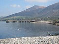
Former RNLI stations can be found all around the coast of the entire British Isles, and were the locations for a fleet of rescue lifeboats.

Contents

The service was established in 1824 as the Royal National Institute for the Preservation of Life from Shipwreck (RNIPLS), later to become the Royal National Lifeboat Institution (RNLI) in 1854, and is operated largely by volunteers. Its headquarters are now at Poole in Dorset and it is a registered charity in both the United Kingdom and Republic of Ireland.

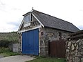
In the days before motor-powered vessels, lifeboat stations were established at strategic locations around the coast, often just a few miles apart, where sailing vessels were known to have been driven ashore in poor conditions. The lifeboats would usually be 'Pulling and Sailing' (P&S) lifeboats, equipped with both oars and sails.

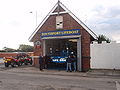
With increasing numbers of motor-powered vessels, the number of shipwrecks declined rapidly. Motor-powered lifeboats were introduced in the early 1900s, which could then cover larger distances in shorter times. Inevitably, the number of lifeboat stations required also declined, and many stations closed. In some places, a well constructed lifeboat house still stands, but in others, no evidence remains.

This is a list of former RNIPLS and RNLI stations, primarily those where the RNLI has now ceased operations from that particular location, town or village. Some RNLI sites, where the station is still in operation, but not necessarily at the original location, are included in the List of RNLI stations.

In a handful of locations, an Independent lifeboat service has been re-established, some using the original RNLI boathouse. Details can be found here: Independent lifeboats in Britain and Ireland

Regions

The information is correct with reference to the Lifeboat Enthusiasts Handbook 2025 unless noted otherwise, [1] and is set out like the RNLI's divisional model. As far as possible it follows a clockwise route around the coast.

List of stations by Region

North & East Region

Station [1] LocationDates [1] CommentsPhoto
Holy Island 1803–1968Just one of four former boathouses survive, the 1884 boathouse, currently used as a Lifeboat Museum. [2] Old Lifeboat Station - geograph.org.uk - 5431340.jpg
Bamburgh Castle 1882–1897The Boat House, currently a holiday let The Boathouse, The Wynding, Bamburgh - geograph.org.uk - 4277418.jpg
Boulmer 1825–1968Now home to Boulmer Volunteer Rescue Service [3] Boulmer Volunteer Rescue Service building - geograph.org.uk - 4140957.jpg
Alnmouth 1854–19352024, Alnmouth Community Rowing Club [4] Lifeboat Station, Alnmouth.jpg
Hauxley 1853–1939Private residence Low Hauxley - geograph.org.uk - 4369311.jpg
Cresswell 1875–1944Now Cresswell Village Hall Cresswell Village Hall - geograph.org.uk - 5675119.jpg
Whitburn 1818–1918Now the site of Whitburn Angling Club. No evidence remains. Whitburn Bay at South Bents - geograph.org.uk - 5843604.jpg
Hendon Beach 1902–1912No evidence remains. Hendon Central Promenade and beach - geograph.org.uk - 4841544.jpg
Seaham 1855–1979Remains of the 1909 boathouse and slipway are still visible. The Coxswain - at Seaham Harbour Marina - geograph.org.uk - 5218371.jpg
Crimdon Dene 1966–1993ILB Station.
West Hartlepool 1847–1906No evidence remains
Seaton Carew 1824–1922No evidence remains Seaton Carew Lifeboat and Crew - 7005691019.jpg
Seaton Snook 1907–1909No evidence remains
Middlesbrough 1854–1895Boathouse demolished by 1913. No evidence remains The River Tees by Dock Point - geograph.org.uk - 3154686.jpg
Teesmouth 1911–2006Station demolished after 2006. Little or no evidence remains. Former Lifeboat Station - geograph.org.uk - 329651.jpg
Saltburn 1919–1922Station building demolished before 1927. No evidence remains From Lifeboats to Lycra--The Changing Tides of Saltburn's "Dangerous Corner" (geograph 7751027).jpg
Runswick 1866–1978Tractor store used by Runswick Bay Rescue Boat since 1982 [5] Lifeboat Station, Runswick Bay - geograph.org.uk - 521509.jpg
Upgang 1865–1919No evidence remains Path to Upgang Beach - geograph.org.uk - 3709796.jpg
Robin Hood's Bay 1881–1931Boathouse now a shelter / public toilets Former lifeboat station, Robin Hood's Bay - geograph.org.uk - 6034370.jpg
Barmston 1884–1898Boathouse demolished, but some foundations may remain The outflow from Barmston Drain - geograph.org.uk - 2150899.jpg
Hornsea 1852–1924
The Old Lifeboat House - geograph.org.uk - 4125616.jpg
Easington 1913–1933No evidence remains Cliffs at Easington - geograph.org.uk - 5603608.jpg
Grimsby 1882–1927No evidence remains
Humber Mouth 1965–1980ILB Station.
Donna Nook 1829–1931Located at the site of what became RAF Donna Nook. No evidence remains. Donna Nook seal spectacular, aerial 2016 - geograph.org.uk - 5193965.jpg
Theddlethorpe 1828–1882Theddlethorpe closed in 1882 due to difficulties launching and lack of crew. No evidence remains. Path through Theddlethorpe Dunes to the sea - geograph.org.uk - 735187.jpg
Sutton 1864–1913Meridale Centre Former Lifeboat Station at Sutton on Sea - geograph.org.uk - 1501553.jpg
Chapel 1870–1898Building remains, currently a discount store.
Gibraltar Point 1825–1830Transferred to Lincs. Coast Shipwreck Assoc. in 1827. No evidence remains. Gibraltar Point NNR beach.jpg
Brancaster 1874–1935No evidence remains on site. Service board hangs in St Mary's Church, Brancaster View east along Brancaster Beach - geograph.org.uk - 5574032.jpg
Blakeney 1862–1935National Trust - Blakeney National Nature Reserve [6] Blakeney point lifeboat station.jpg
Mundesley 1811–1895Independent station operated since 1972 by Mundesley Volunteer Inshore Lifeboat -2022-08-07 Beach access path, Mundesley beach, Norfolk.JPG
Bacton 1822–1882No evidence remains, believed lost by coastal erosion Beach and sea defences at Bacton - geograph.org.uk - 5889397.jpg
Palling 1852–1930Independent lifeboat operated since 1972 by Sea Palling Independent Rescue [7] The beach at Sea Palling - geograph.org.uk - 5877872.jpg
Winterton 1823–1925Just the building foundations remain Foundations of a building in the Winterton dunes - geograph.org.uk - 3968955.jpg
Caister 1845–1969Station now run by Caister Volunteer Lifeboat Service [8] Caister Lifeboat Station - geograph.org.uk - 67197.jpg
Corton 1869–1879No evidence remains
South Broads 2001–2011ILB Station.
Pakefield 1840–1922Nothing remains of three previous boathouses, some believed lost by coastal erosion Pakefield beach - geograph.org.uk - 727570.jpg
Kessingland 1867–1936Very modified private residence
Dunwich 1873–1903Boathouse site lost to coastal erosion Dunwich beach and car park - geograph.org.uk - 6513649.jpg
Thorpeness 1853–1900No evidence remains
Orford 1826–1835
Woodbridge Haven 1826–1853

South East Region

Station [1] LocationDates [1] CommentsPhoto
Kingsgate 1862–1897No evidence remains Whiteness Gap - geograph.org.uk - 1900596.jpg
Broadstairs 1868–1912Harbour Office and Gift Shop Old Lifeboat House, Broadstairs - geograph.org.uk - 5844603.jpg
North Deal 1865–1932Deal Angling Club Deal Angling Club (1919) - geograph.org.uk - 3839330.jpg
Kingsdown 1866–1927Private residence Sea Front at Kingsdown - geograph.org.uk - 3710173.jpg
Folkestone 1893–1930Lifeboat house demolished after 1936. No evidence remains. Site recently redeveloped. Folkestone, Leas Lift - geograph.org.uk - 3160087.jpg
Hythe, Sandgate & Folkestone 1876–1893Lifeboat house demolished in 1956. No evidence remains. The end of the Royal Military Canal Path, Seabrook - geograph.org.uk - 6348940.jpg
Hythe 1893–1940Two boathouses still remain, one located behind the second. Liftboat Stations (geograph 6956848).jpg
Dymchurch 1826–1838Was located at Martello Tower No.27 at Dymchurch, but named 'Dungeness No.27 Tower' Lifeboat Station until 1836. Station closed in 1838. Tower No.27 demolished in 1841. Pic - Martello Tower No.25 Dymchurch, Martello Tower No. 25 - geograph.org.uk - 3143430.jpg
New Romney 1871–1928Boathouse demolished to extend Marine Parade into Coast Road. Site of Littlestone Lifeboat Station - geograph.org.uk - 1813686.jpg
Rye 1857–1901Named Camber Lifeboat Station until 1862. No evidence remains. The beach at Camber from a footpath - geograph.org.uk - 1504182.jpg
Winchelsea 1856–1910Named Rye Lifeboat Station until 1862. Renamed Rye Harbour in 1910. Mary Stanford Lifeboat House (geograph 6805162).jpg
Worthing 1964–1967Private residence: 107 Marine Parade [9] Former Lifeboat Station, Marine Parade, Worthing.jpg
Chichester Harbour 1867–1884No evidence remains The Board Walk,East Head,West Wittering - geograph.org.uk - 1970696.jpg
Southsea 1886–1918Formerly on the promenade at Southsea Common; no evidence remains The Yellow Fever Monument on Southsea seafront - geograph.org.uk - 3091590.jpg
Ryde 1894–1923Boathouse located on the Pier; no evidence remains. Ryde Pier (geograph 7001628).jpg
Atherfield 1890–1915No evidence of boathouse remains, but the 1:3 steep slipway down the cliff may still be visible [10] Cliff, Atherfield Point (geograph 7419498).jpg
Brighstone Grange 1860–1915Now a site for static caravans; little evidence remains Grange Chine, Isle of Wight, England (2).jpg
Brooke 1860–1937Derelict ruin Old lifeboat house, Brook Chine - geograph.org.uk - 5467337.jpg
Totland Bay 1885–1924Community Hall? Totland Bay old lifeboat station.jpg

South West Region

Station [1] LocationDates [1] CommentsPhoto
Bournemouth 1965–1972ILB Station.
Studland 1826–1848No evidence remains
Chapman's Pool 1866–1880Two refurbished boathouses stand on the site of the lifeboat station. It is not clear which one may have been constructed from the old lifeboat house. Chapman's Pool Boathouse, Dorset, RNLI Lifeboat Station 1880.jpg
Kimmeridge 1868–1896No evidence remains Western end of Kimmeridge Bay - geograph.org.uk - 695226.jpg
Portland 1826–1851
St Sampson (1880–1881)Former boathouse still exists, at North Side Street/ Trafalgar Road junction
La Lande 1878–1880Little if anything remains of the boathouse, which was located just to the north of what is now Beaucette Marina.
Sidmouth 1869–1912A doorway arch marked RNLBI is all that remains of the old station. It is located across the road from the new Independent Sidmouth Lifeboat, established in 1968. [11] The first station in Ham Lane (geograph 7646822).jpg
Torquay 1876–1928No evidence remains. [12]
Hope Cove 1878–1930Under refurbishment The Lifeboat House at Inner Hope Cove - geograph.org.uk - 1423189.jpg
Yealm River 1878–1927Private residence. [13] River Yealm, Newton Ferrers - geograph.org.uk - 4836598.jpg
Polkerris 1859–1922Moved to Fowey where it was easier to find a crew. The boathouse is now a café. [14] Polkerris old lifeboat house.JPG
Mevagissey 1869–1930The lifeboat was based in the village of Portmellon until 1888 when it was moved to Mevagissey. The Portmellon boathouse is now a private residence, and the slipway is still visible. The boathouse at Mevagissey is now an aquarium. [14] Mevagissey aquarium (9447).jpg
Portloe 1870–1887A boathouse built in 1870 is now a church. A second boathouse built in 1877 is now a private residence. [14] Portloe church - geograph.org.uk - 2124041.jpg
Porthoustock 1869–1942Now used as a village hall. [14] Porthoustock - geograph.org.uk - 3210316.jpg
Coverack 1901–1980The 1901 boathouse is now a Fish & Chip restaurant/ take-away. [15] The Lifeboat House - geograph.org.uk - 2668588.jpg
Mullion 1867–1908Private residence. [15] The harbour roadway, Mullion Cove - geograph.org.uk - 4798301.jpg
Porthleven 1863–1929Building later used as a shipwreck museum. Now an art studio. Porthleven Lifeboat Station (7793).jpg
Marazion 1990–2001ILB Station. [15]
Penzance 1803–1917Station closed between 1812–1826 and again 1828-1851. A boathouse built in 1884 still stands. [15] Old Lifeboat House, Penzance (5700741854).jpg
St Agnes, IOS 1890–1920Boathouse now used as a store. [16] St Agnes' Lifeboat station and slipway, Isles of Scilly.JPG
Hayle 1866–1920Now a builders yard, no evidence remains.
Morte Bay 1871–1900An outstation from Ilfracombe. The boathouse is now a beach / surf hire shop. The entrance to Woolacombe sands on Challacombe Road. - geograph.org.uk - 1236502.jpg
Lynmouth 1869–1944Destroyed in the Lynmouth flood of 1952 but rebuilt and is now the Flood Memorial Hall. [18] Lynmouth Flood Memorial Hall.jpg
Watchet 1875–1944Now Watchet Community Library. [19] Watchet library former lifeboat station.jpg
Pill 1971–1974

Wales, West & Isle of Man Region

Station [1] LocationDates [1] CommentsPhoto
Atlantic College 1963–2013Continues training and building boats Atlantic College St.Donat's - geograph.org.uk - 4960181.jpg
Llanelli 1869–1871Lifeboat stored on davits, on the Llanelli Pilot / Lightship.
Pembrey 1863–1887No evidence remains. Low tide in Pembrey Burrows - geograph.org.uk - 7418626.jpg
Ferryside 1835–1960
  • Formerly Carmarthen, and Carmarthen Bay Lifeboat Station until ~1892
  • Independent lifeboat service since 1966, Ferryside Lifeboat
The River Towy Yacht Club, Ferryside, St Ishmael (geograph 5196282).jpg
Carmarthen 1835–1843
Solva 1869–1887Station dedicated 1869 [21] [22] Solva lifeboat station - geograph.org.uk - 4575131.jpg
Newport 1884–1894 [23] The old lifeboat station - geograph.org.uk - 531626.jpg
Llanaelhaearn 1883–1901Located at Trefor Pier [24] Pier, Trefor Harbour. - panoramio (1).jpg
Llanddwyn 1826–1907Boathouse / Store PilotscottagesonLlanddwyn.jpg
Rhosneigr 1872–1924Boathouse / Store Rhosneigr Old Lifeboat House (geograph 7755328).jpg
Rhoscolyn 1830–1929Two former lifeboat houses remain, 1877 (private dwelling), 1903 (holiday let)
  • The Old Lifeboat House at Rhoscolyn - geograph.org.uk - 5440182.jpg
  • Rhoscolyn Lifeboat Station - Now a dwelling - geograph.org.uk - 2846872.jpg
Porth Ruffydd 1891–1904The steps, and some rubble, are all that remains of the former lifeboat station. [25] Porth Ruffydd - geograph.org.uk - 2606693.jpg
Cemlyn 1877–1919Derelict, some foundations and slipway survive Slipway near the lifeboat memorial - geograph.org.uk - 1215874.jpg
Cemaes
1872–1932Derelict, some foundations and slipway survive [26] Site of the old lifeboat station at Porth yr Ogof - geograph.org.uk - 1178303.jpg
Bull Bay 1868–1926Yacht & Boat Club Bull Bay on Anglesey (geograph 7348244).jpg
Penmon 1831–1915Former boathouse is now a holiday let Coastguard Station and former Penmon Lifeboat Station - geograph.org.uk - 1457673.jpg
Llanddulas 1869–1932Former boathouse is now a private residence The Old Lifeboat House, Llanddulas - geograph.org.uk - 5034772.jpg
Point of Air 1826–1894Former coxswains residence still exists at Presthaven Holiday Park Bus stop in Presthaven Sands Caravan Park - geograph.org.uk - 3504663.jpg
Point of Ayr 1894–1923No evidence remains Talacre Beach - geograph.org.uk - 3500247.jpg
Mostyn 1835–1850No evidence remains
Castletown 1856–1922Former boathouse is now a private residence Former lifeboat station Castletown - geograph.org.uk - 1700624.jpg
Formby 1894–1919Some foundations still visible in shifting sand. Formby lifeboat and crew.jpg
Southport 1860–1925, 1988–2022Building pictured built in 1886 and closed in 1925. Reopened by Southport Offshore Rescue Trust from 1988–2022. Currently used as storage by Sefton Council. Aa Southport lifeboat station 01.jpg
Lytham 1851–1931Lifeboat Museum Old lifeboat station and windmill, Lytham - geograph.org.uk - 2916407.jpg
St Annes 1881–1925Former boathouse is now a funeral directors Former Lifeboat House - geograph.org.uk - 2905660.jpg
Seascale 1875–1895Site is now part of a car park. No evidence remains. Seascale View - geograph.org.uk - 4879478.jpg
Whitehaven 1865–1924Demolished; now Whitehaven Marina Yard. No evidence remains. Whitehaven Boatyard, North Shore Road - geograph.org.uk - 6245369.jpg
Maryport 1865–1949East Wall of old lifeboat house still standing Maryport fishing boats - geograph.org.uk - 4036415.jpg

Scotland Region

Station [1] LocationDates [1] CommentsPhoto
Balcary 1884–1931Private residence The Boat House at Balcary Point (geograph 7205786).jpg
Isle of Whithorn 1869–1919Ruin Ruins of the Lifeboat Station, Isle of Whithorn - geograph.org.uk - 4502964.jpg
Port Logan 1866–1932Village Hall Village Hall, Port Logan - geograph.org.uk - 6236894.jpg
Ballantrae 1871–1919Boat House / store Old lifeboat house and sheds, Ballantrae, South Ayrshire.jpg
Ayr 1859–1932Seafood restaurant (Closed) South Harbour Street by River Ayr - geograph.org.uk - 4443870.jpg
Irvine 1860–1914Demolished; now a car park Beach Drive Car Park, Irvine - geograph.org.uk - 6597665.jpg
Ardrossan 1869–1930Was located on the West Pier, near the lighthouse, demolished. Lighthouse, Ardrossan - geograph.org.uk - 5820398.jpg
Southend (Cantyre) 1869–1930Currently a Holiday let The Old Boathouse, Dunaverty (2) - geograph.org.uk - 735863.jpg
Machrihanish 1912–1930Boathouse / store Disused lifeboat station Machrihanish - geograph.org.uk - 23121.jpg
Kildonan 1870–1901Boathouse still standing, use undetermined Seal shore camping - geograph.org.uk - 2148090.jpg
Stronsay 1952–19721911 Lifeboat Station dismantled in 1949, only the slipway remains. A building used as a station from the 1950s, now Cardinham House, remains. Stronsay - Pier at Whithall - geograph.org.uk - 3744774.jpg
Huna 1877–1930Store Building at Huna (geograph 7086732).jpg
Ackergill 1878–1932Boathouse / store, and separate slipway still exist. Ackergillshore slipway - geograph.org.uk - 1428647.jpg
Dornoch Firth and Embo 1886–1904No evidence found Embo Links and the north end of Royal Dornoch Golf Course - geograph.org.uk - 4093723.jpg
Cromarty 1911–1968Demolished?
Nairn 1878–1911Lifeboat House demolished to make way for the harbour extension in 1930s Harbour at Nairn - geograph.org.uk - 3059608.jpg
Lossiemouth 1859–1923Marine engineers workshop Marine engineers workshop - formerly the Lifeboat station - geograph.org.uk - 2509267.jpg
Whitehills 1924–1969Private residence The Old Lifeboat Station, Whitehills - geograph.org.uk - 1832270.jpg
Banff and Macduff 1921–19241860 boathouse demolished in 1877. 1877 boathouse is now private residence Bridgend - geograph.org.uk - 1762752.jpg
Whitelink Bay 1878–1905Demolished; now Inverallochy Golf Course
Port Erroll 1915–1921Believed converted to public toilets Outer harbour, Port Errol - geograph.org.uk - 5780979.jpg
Newburgh 1877–1965Boathouse / Store The first lifeboat station in Scotland (Newburgh) (geograph 7562149).jpg
Gourdon 1878–1969Private residence on William Street
Johnshaven 1891–1928Johnshaven Heritage Hub Museum Lifeboat House - geograph.org.uk - 5332516.jpg
Buddon Ness 1867–1894No evidence remains Beach, Barry Ness - geograph.org.uk - 1436083.jpg
St Andrews [27] 1860–1938St Andrews Sailing Club St Andrews Sailing Club - geograph.org.uk - 6248878.jpg
Crail 1884–1923 Crail Golf Course Store Former lifeboat station - geograph.org.uk - 112890.jpg
Buckhaven 1900–1932Derelict lifeboat house demolished in 1950s; harbour filled in. Buckhaven - geograph.org.uk - 6464701.jpg
Skateraw 1907–1943Demolished Foundations of Skateraw Lifeboat Shed (geograph 7784730).jpg
St Abbs 1911–2015In operation but as an independent lifeboat station. St Abbs Lifeboat [28] Lifeboat Station, St Abbs Harbour - geograph.org.uk - 5778029.jpg

Ireland Region

Station [1] LocationDates [1] CommentsPhoto
Carrickfergus 1896–1913Boathouse was constructed alongside the pier. Only the pilings now remain. Former lifeboat station, Carrickfergus - geograph.org.uk - 621010.jpg
Groomsport 1858–1920Community hall The Groomsport anchor - geograph.org.uk - 189529.jpg
Ballywalter 1866–1906Boat House / Store in 2012. Former lifeboathouse, Ballywalter - geograph.org.uk - 2943910.jpg
Cloughey-Portavogie 1965–1981 Portavogie Harbour - geograph.org.uk - 24189.jpg
Cloughey 1888–1965Private residence [29]
St John's Point 1835–1843Unknown location
Rossglass
1825–1835Unknown location
Killough
1901–1914Now believed to be a private residence
Tyrella 1860–1899Building still there.
Greenore 1894–1920Vacant building Former lifeboathouse, Greenore - geograph.org.uk - 397263.jpg
Giles Quay 1879–1912Private residence Sandy beach at Giles Quay - geograph.org.uk - 5841423.jpg
Blackrock 1880–1935Building still there Blackrock Seashore - geograph.org.uk - 2091814.jpg
Drogheda No.1 1856–1899 Little Tern nesting sites, Baltray, Co. Louth - geograph.org.uk - 881278.jpg
Drogheda No.2 1872–1926Derelict for many years, converted to a private residence in 2007. [30] Maiden Tower, Mornington, and Mouth of River Boyne - geograph.org.uk - 534835.jpg
Balbriggan 1875–1898Lifeboat house constructed underneath the railway arch. In 2025, the building is under refurbishment. Photographed In Balbriggan - County Dublin, Ireland (537666895).jpg
Rogerstown 1874–1882Believed demolished Rogerstown Estuary-1.jpg
Poolbeg 1862–1959Was at the small harbour west of Poolbeg disused power station. No evidence remains. Poolbeg Generating Station (48485989116).jpg
Greystones 1872–1895Retail unit Former RNLI Lifeboat House, Greystones, Co. Wicklow 2025.jpg
Cahore 1857–1916Store, located next to Cahore Independent Lifeboat house Former RNLI Lifeboat House Cahore Wexford May 2025.jpg
Carnsore 1859–1897Private residence Former Carnsore RNLI Lifeboat House, Carne, Co. Wexford 2025.jpg
Duncannon 1869–1886Boathouse / store at Duncannon pier Former RNLI Lifeboat House, Duncannon, Co. Wexford 2025.jpg
Ardmore 1858–1895Private residence Boat House - geograph.org.uk - 486449.jpg
Queenstown 1866–1920Cobh Sea Scout HQ
Derrynane 1844–1855Boathouse believed to be white building next to Derrynane Beach Car Park
Westport 1857–1862Boathouse / Store
Killybegs 1941–1945
Culdaff 1892–1913Boathouse / store Lifeboat Station, Bunnagee - geograph.org.uk - 1329072.jpg
Greencastle 1864–1928Private residence

See also

References

  1. 1 2 3 4 5 6 7 8 9 10 11 12 13 Leonard, Richie; Denton, Tony (2025). Lifeboat Enthusiasts Handbook 2025. Lifeboats Enthusiasts Society. pp. 115–126.
  2. "The Lifeboat Museum". Visit Lindisfarne. Retrieved 25 March 2024.
  3. "Boulmer Volunteer Rescue Service". Boulmer Volunteer Rescue Service. Retrieved 25 March 2024.
  4. "Old Lifeboat Station, Alnmouth". Co-Curate. Retrieved 25 March 2024.
  5. "Runswick Bay Rescue Boat". Runswick Bay Rescue. Retrieved 25 March 2024.
  6. "NT - Blakeney National Nature Reserve". Visit East of England. Retrieved 27 March 2024.
  7. "Sea Palling Lifeboat" . Retrieved 30 March 2024.
  8. "Caister Lifeboat". Caister Lifeboat. Retrieved 31 March 2024.
  9. "Worthing Lifeboat Town" . Retrieved 20 March 2024.
  10. "Atherfield Lifeboat". Wightpedia. Retrieved 30 March 2024.
  11. Leach, Nicholas (2009). Devon's Lifeboat Heritage. Chacewater: Twelveheads Press. pp. 4–5. ISBN   9780906294727.
  12. Leach 2009, p. 13.
  13. Leach 2009, pp. 28–29.
  14. 1 2 3 4 Leach, Nicholas (2006). Cornwall's Lifeboat Heritage. Twelveheads Press. pp. 35–39. ISBN   0-906294-43-6.
  15. 1 2 3 4 Leach 2006, pp. 38–41.
  16. Leach 2006, p. 43.
  17. Leach 2006, p. 45.
  18. Leach 2009, pp. 49–50.
  19. Farr, Grahame (1974). Ships and Harbours of Exmoor (2nd ed.). The Exmoor Press. p. 61. ISBN   0-900131-15-2.
  20. "RNLI: Burry Port" . Retrieved 30 March 2024.
  21. "Dedication stone, Solva lifeboat station". Geograph. Geograph.org.uk. Retrieved 19 March 2024.
  22. "Lifeboat Station, Solva (544165)". Coflein. RCAHMW . Retrieved 19 March 2024.
  23. "The Cwm, old lifeboat station" . Retrieved 19 March 2024.
  24. "Lifeboat House, Trefor Pier (518861)". Coflein. RCAHMW . Retrieved 19 March 2024.
  25. "Porth Ruffydd Lifeboat Station". coflein. Retrieved 20 March 2024.
  26. "Cemaes Bay Lifeboat Station". Coflein,gov.uk. Retrieved 27 March 2024.
  27. "St Andrews had a Lifeboat Station". St Andrews Museum. 27 January 2021. Retrieved 19 March 2024.
  28. "St Abbs Lifeboat". St Abbs Lifeboat. Retrieved 28 March 2024.
  29. "Portaferry Lifeboat - History". Portaferrylifeboat.com. Retrieved 19 March 2024.
  30. "The Boathouse put up for sale". Irish Independent. 8 September 2017. Retrieved 31 March 2024.