Lower Naugatuck Valley

Last updated

The Lower Naugatuck Valley, also known locally as simply "The Valley", is a geographic area located around the confluence of the southern parts of the Housatonic and Naugatuck Rivers. It consists of the municipalities of Seymour, Derby, Ansonia, and outside the Naugatuck watershed, Shelton, which constitute the Valley Council of Governments. The scope of the Lower Naugatuck Valley is also sometimes extended to encompass the next three towns upstream and to the north, which are Beacon Falls, Naugatuck, and Oxford, Connecticut.

Contents

During the 19th and 20th centuries, the Valley was one of the main manufacturing centers in New England, and most of the Valley communities were emblematic New England mill towns.

In 2000, the seven towns in the extended Lower Naugatuck Valley region were selected as an All-America City, varying the title of that award as "All-America Valley".

History

This was the most prosperous part of Connecticut in the early days of industrialization. The region was the location of key factories in national industries, most notably the brass industry, rubber manufacturing, petrochemical production and shipbuilding. Naugatuck was the birthplace of Naugahyde. This industrial past has given the region a heavy urban landscape, with many factory buildings rising prominently along the riverside and dominating the central districts of the towns.

After the Great Depression, however, the area began a prolonged period of deindustrialization and lost large portions of its manufacturing base, leaving behind weak economies and empty buildings typical of Rust Belt landscapes. In 1955, the area's fortunes were further impaired when floodwaters brought by Hurricane Diane devastated the region. From Naugatuck to Shelton, entire downtown neighborhoods were washed away, leaving the region in disaster. High unemployment, poverty, and isolation marked the more urban Naugatuck Valley cities through the 1980s. Floodwaters even went into surrounding areas such as the lower portion of the Greater Waterbury area.

A major effort to revitalize the economy of the Naugatuck Valley started with the creation of the Naugatuck Valley Development Corportion in 1979, a nonprofit, public private partnership headquartered in Waterbury. The corporation board of directors accepted the challenge of renovation and reuse of the closed and deteriorating one million square foot former Chase Brass mill.[1] "Chase Plant to be Revitalized", Waterbury Republican, May 26, 1979

The board of directors recruited Charles J Blankenship to be Executive Director and Chief Executive Officer in November 1979. Blankenship was previously the Pennsylvania Director of Economic Development. He was given the responsibility of turning the deteriorated property into a new industrial complex with much needed jobs and tax base. [2] "Industrial Development Agency Now Has a Director," Waterbury Republican, November 18, 1979. The property was named the Waterbury Industrial Commons and work quickly began on renovations and tenant leasing. Unused land was developed into two industrial parks and parcels were sold to fund renovations. [3] "Big Year Ahead for Former Case Plant", Waterbury Republican, January 27, 1980.

The conversion of the industrial complex into prime industrial space offered renewed hope to other aging mill towns in the Naugatuck Valley seeking to refurbish old buildings for modern use. [4] "Turning Old into New", The New York Times, June 26, 1983. The successfully completed project was sold to private developers in January 1983. Blankenship was recruited to a new position after negotiating the final sale.[5] "Commons Leader Leaving", Waterbury Republican, January 15, 1984.

Since the early 1990s, rural and southern portions of the Naugatuck Valley have evolved into sprawling commuter towns. Communities like Shelton and Oxford have become popular bedroom communities for residents working in New York City and lower Fairfield County. Vast sections of farmland up and down the Naugatuck Valley have also been developed for the building of luxury homes. Despite this suburbanization, however, the region is still tied to its core city centers like Derby and downtown areas of Ansonia and Naugatuck, thus retaining its working-class flavor.

During the Vietnam War, factories such as the Naugatuck chemical plant were key players in the production of the chemical Agent Orange, heavily used in herbicidal warfare.

Culture

Along with other towns in Connecticut, the Naugatuck Valley maintains a high emotional and cultural involvement with its high school football teams and their rivalries. Football shapes many peoples lives in the valley with high school alumni, faculty and students giving a huge fan base which also includes families and town citizens. The Naugatuck Valley League serves six high schools in the Valley: Derby, Naugatuck, Oxford, Woodland, Seymour, and Ansonia. The Naugatuck Valley League also contains nine schools that are outside of the Valley: Kennedy, Torrington, Watertown, Crosby, Holy Cross, St. Paul, Wilby, Wolcott, and Sacred Heart. Politically, the Valley is far more conservative than much of the rest of Connecticut, and supported George W. Bush in the 2004 election, centrist Senator Joe Lieberman in the 2006 Democratic primary; and favored Republicans John McCain in the 2008 election, Mitt Romney in the 2012 election, Donald Trump in the 2016 election, and Thomas C. Foley in the 2010 and 2014 gubernatorial elections.

The Valley is home to the Valley Arts Council. The council was established under the guidance of the Greater Valley Chamber of Commerce in 2000. The Council serves the seven municipalities that comprise this region. The region is particularly strong with many talented Artists of all skills, mediums and levels. The Arts Council has a fine Art gallery on Main Street in downtown Ansonia (est.2019). The gallery was in neighboring Derby for over ten years. Surprisingly, the Valley is a wealth of Artists and Artisans. Some world class artists, in their specific genres, work and live in these communities.

The Valley also has a notable population of Poles, with shops and other various services catering to this population.

Related Research Articles

<span class="mw-page-title-main">New Haven County, Connecticut</span> County in Connecticut, United States

New Haven County is a county in the south central part of the U.S. state of Connecticut. As of the 2020 census, the population was 864,835, making it the third-most populous county in Connecticut. Two of the state's top 5 largest cities, New Haven (3rd) and Waterbury (5th), are part of New Haven County.

<span class="mw-page-title-main">Beacon Falls, Connecticut</span> Town in Connecticut, United States

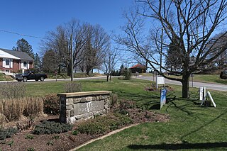
Beacon Falls is a town in western New Haven County, Connecticut, United States. The town is part of the Naugatuck Valley Planning Region. It lies in the southwestern part of the state, and is bisected by the Naugatuck River. The population was 6,000 at the 2020 census, down from 6,049 at the 2010 census.

<span class="mw-page-title-main">Prospect, Connecticut</span> Town in Connecticut, United States

Prospect is a town in the Naugatuck Valley Planning Region, Connecticut, United States. It is a suburb of the nearby city of Waterbury to its north, and is on the north-eastern fringes of the New York metropolitan area. The population was estimated to be 9,401 in 2020. Prospect is part of the Waterbury NECTA and of the historical New Haven County. Prospect is also a member of the regional health district Chesprocott, along with Cheshire and Wolcott.

<span class="mw-page-title-main">Seymour, Connecticut</span> Town in Connecticut, United States

Seymour is a town located in New Haven County, Connecticut, United States. The town is part of the Naugatuck Valley Planning Region. The population was 16,748 at the 2020 census. Seymour is bordered by the towns of Oxford and Beacon Falls to the north, Bethany and Woodbridge to the east, Ansonia and Derby to the south, and Shelton to the west.

<span class="mw-page-title-main">Ansonia, Connecticut</span> City in Connecticut, United States

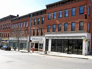
Ansonia is a city in New Haven County, Connecticut, United States. Located on the Naugatuck River, it is immediately north of Derby, and about 12 miles (19 km) northwest of New Haven. The city is part of the Naugatuck Valley Planning Region. The population was 18,918 at the time of the 2020 census. The ZIP code for Ansonia is 06401. The city is served by the Metro-North Railroad. Ansonia Station is a stop on the railroad passenger commuter service's Waterbury Branch connecting to New York's Grand Central Terminal. Ansonia also is served by the Connecticut Transit bus carrier. Connecticut Route 8 serves Ansonia.

<span class="mw-page-title-main">Derby, Connecticut</span> City in Connecticut, United States

Derby is a city in New Haven County, Connecticut, United States, approximately 8 miles (13 km) west-northwest of New Haven. It is located in southwest Connecticut at the confluence of the Housatonic and Naugatuck rivers. It shares borders with the cities of Ansonia to the north and Shelton to the southwest, and the towns of Orange to the south, Seymour to the northwest, and Woodbridge to the east. The city is part of the Naugatuck Valley Planning Region. The population was 12,325 at the 2020 census. It is the smallest city in Connecticut by area, at 5.3 square miles (14 km2).

<span class="mw-page-title-main">Torrington, Connecticut</span> City in Connecticut, United States

Torrington is the most populated municipality and largest city in Litchfield County, Connecticut and the Northwest Hills Planning Region. It is also the core city of Greater Torrington, one of the largest micropolitan areas in the United States. The city population was 35,515 according to the 2020 census. The city is located roughly 23 miles (37 km) west of Hartford, 34 miles (55 km) southwest of Springfield, Massachusetts, 67 miles (108 km) southeast of Albany, New York, 84 miles (135 km) northeast of New York City, and 127 miles (204 km) west of Boston, Massachusetts.

<span class="mw-page-title-main">Naugatuck, Connecticut</span> Consolidated borough and town in Connecticut, US

Naugatuck is a consolidated borough and town in New Haven County, Connecticut, United States. The town, part of the Naugatuck Valley Planning Region, had a population of 31,519 as of the 2020 Census.

<span class="mw-page-title-main">Waterbury, Connecticut</span> City in Connecticut, United States

Waterbury is a city in the U.S. state of Connecticut. Waterbury had a population of 114,403 as of the 2020 Census. The city is 33 miles (53 km) southwest of Hartford and 77 miles (124 km) northeast of New York City. Waterbury is the largest city in the Naugatuck Valley Planning Region and second-largest city in New Haven County.

The Naugatuck River Valley is the watershed area of the Naugatuck River in the western part of Connecticut. The Naugatuck Valley straddles parts of Litchfield County, New Haven, and Fairfield counties. The Route 8 corridor and Waterbury Branch of the Metro-North railroad line run along the river valley. Geographically, it comprises the municipalities located within the Naugatuck River basin. During the 19th and 20th centuries, the area was one of the main manufacturing centers in New England, and most of the communities around the river were emblematic New England mill towns.

The New Haven Register is a daily newspaper published in New Haven, Connecticut. It is owned by Hearst Communications. The Register's main office is located at 100 Gando Drive in New Haven. The Register was established about 1812 and is one of the oldest continuously published newspapers in the U.S. In the early 20th century it was bought by John Day Jackson. The Jackson family owned the Register, published weekday evenings and Saturday and Sunday mornings, and The Journal-Courier, a morning weekday paper, until they were combined in 1987 into a seven-day morning Register.

<span class="mw-page-title-main">Connecticut Route 8</span> Highway in Connecticut

Route 8 is a 67.36-mile (108.41 km) state highway in Connecticut that runs north–south from Bridgeport, through Waterbury, all the way to the Massachusetts state line where it continues as Massachusetts Route 8. Most of the highway is a four-lane freeway but the northernmost 8.8 miles (14.2 km) is a two-lane surface road.

<span class="mw-page-title-main">Greater Bridgeport</span> Metropolitan statistical area in Connecticut, United States

Bridgeport-Stamford-Norwalk is a metropolitan area in the U.S. state of Connecticut. The area is located in Southwestern Connecticut. In its most conservative form the area consists of the city of Bridgeport and five surrounding towns—Easton, Fairfield, Monroe, Stratford, and Trumbull. This definition of the Bridgeport area has a population of more than 305,000 and is within the Bridgeport-Stamford-Norwalk-Danbury metropolitan statistical area, which consists of all of Fairfield County, Connecticut. The estimated 2015 county population was 948,053. The area is numbered as part of the New York-Newark Combined Statistical Area NY-NJ-CT-PA by the United States Census Bureau.

<span class="mw-page-title-main">Connecticut's 5th congressional district</span> U.S. House district for Connecticut

Connecticut's 5th congressional district is a congressional district in the U.S. state of Connecticut. Located in the western part of the state and spanning across parts of Fairfield, Litchfield, New Haven, and Hartford Counties, the district runs from Meriden and New Britain in central Connecticut, westward to Danbury and the surrounding Housatonic Valley, encompassing the Farmington Valley, Upper Naugatuck River Valley, and the Litchfield Hills. The district also includes most of Waterbury.

<span class="mw-page-title-main">Connecticut Route 115</span> State highway in New Haven County, Connecticut, US

Route 115 is a Connecticut state highway in the Lower Naugatuck River Valley area, running from Route 34 in Derby to Route 67 in Seymour. The road runs along the east bank of the lower Naugatuck River.

<span class="mw-page-title-main">Central Naugatuck Valley</span> Place in Connecticut, United States

The Central Naugatuck Valley is a region of Connecticut in New Haven and Litchfield counties located approximately 70 miles (110 km) northeast of New York City and 110 miles (180 km) southwest of Boston, United States. The region comprises 13 towns: Beacon Falls, Bethlehem, Cheshire, Middlebury, Naugatuck, Oxford, Prospect, Southbury, Thomaston, Waterbury, Watertown, Wolcott, and Woodbury.

The Valley Independent Sentinel is an online-only, non-profit news site covering the lower Naugatuck Valley of Connecticut, United States.

<span class="mw-page-title-main">Mad River (Connecticut)</span> River in Connecticut, United States

The Mad River is a river that flows through northern New Haven County, Connecticut, in the United States.

<span class="mw-page-title-main">Naugatuck Valley Planning Region, Connecticut</span> Planning region in Connecticut

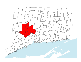
The Naugatuck Valley Planning Region is a planning region and county-equivalent in Connecticut. It is served by the coterminous Naugatuck Valley Council of Governments (NVCOG). In 2022, planning regions were approved to replace Connecticut's counties as county-equivalents for statistical purposes, with full implementation occurring by 2024.

References