In the United States, a metropolitan statistical area (MSA) is a geographical region with a relatively high population density at its core and close economic ties throughout the region. Such regions are not legally incorporated as a city or town would be and are not legal administrative divisions like counties or separate entities such as states. As a result, sometimes the precise definition of a given metropolitan area will vary between sources. The statistical criteria for a standard metropolitan area were defined in 1949 and redefined as a metropolitan statistical area in 1983.

The Blacksburg-Christiansburg Metropolitan Statistical Area, formerly the Blacksburg-Christiansburg-Radford Metropolitan Statistical Area, is a Metropolitan Statistical Area (MSA) as defined by the United States Office of Management and Budget (OMB) located in the New River Valley of Southwest Virginia. As of the 2020 census, the MSA had a population of 181,863.
The Charleston Metropolitan Statistical Area, as defined by the United States Census Bureau, is an area consisting of three counties in West Virginia, anchored by the city of Charleston. It is the largest metropolitan area entirely within the state of West Virginia. The Huntington Metro Area adds to the Charleston–Huntington, WV-OH-KY CSA and spans three states, while the core county of the Charleston area, Kanawha County, is more populous than the West Virginia portion of the Huntington area.

The Colorado Springs, CO, Metropolitan Statistical Area is a United States Office of Management and Budget defined Metropolitan Statistical Area (MSA) located in the Colorado Springs region of the State of Colorado. The 2020 United States census counted a population of 755,105, an increase of 17.0% since the 2010 United States Census. The Colorado Springs MSA is the 79th-most populous MSA in the United States. The Colorado Springs MSA encompasses El Paso County and Teller County, Colorado. Approximately 88.40% percent of the MSA's population live in cities or CDPs. The Colorado Springs Metropolitan Statistical Area is the second-most populous component of the Front Range Urban Corridor.

The United States Office of Management and Budget has defined the 12-county Denver–Aurora, CO Combined Statistical Area comprising the Denver–Aurora–Lakewood, CO Metropolitan Statistical Area, the Boulder, CO Metropolitan Statistical Area, and the Greeley, CO Metropolitan Statistical Area. The United States Census Bureau estimates that the population was 3,214,218 as of July 1, 2012, an increase of +3.99% since the 2010 United States Census, and ranking as the 16th most populous metropolitan combined statistical area and the 17th most populous primary statistical area of the United States. The population estimate for 2020 was 3,652,385.

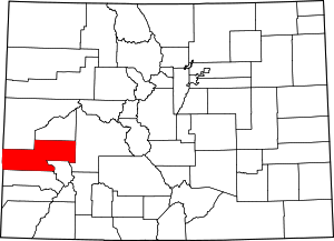
The Durango Micropolitan Statistical Area is a United States Census Bureau defined Micropolitan Statistical Area located in the Durango area of the State of Colorado. The Durango Micropolitan Statistical Area is defined as La Plata County, Colorado. The Micropolitan Statistical Area had a population of 43,941 at the 2000 Census. A July 1, 2009 U.S. Census Bureau estimate placed the population at 51,464.

The Fort Morgan Micropolitan Statistical Area is a United States Census Bureau defined Micropolitan Statistical Area located in the Fort Morgan area of the State of Colorado. The Fort Morgan Micropolitan Statistical Area is defined as Morgan County, Colorado. The Micropolitan Statistical Area had a population of 29,108 at the 2020 Census. A July 1, 2023 U.S. Census Bureau estimate placed the population at 29,524.

The Silverthorne Micropolitan Statistical Area is a United States Census Bureau defined Micropolitan Statistical Area located in the Silverthorne area of the State of Colorado. The Silverthorne Micropolitan Statistical Area is defined as Summit County, Colorado. The Micropolitan Statistical Area had a population of 23,548 at the 2000 Census. A July 1, 2009 U.S. Census Bureau estimate placed the population at 27,239.

The Sterling Micropolitan Statistical Area is a United States Census Bureau defined Micropolitan Statistical Area located in the Sterling area of the State of Colorado. The Sterling Micropolitan Statistical Area is defined as Logan County, Colorado. The Micropolitan Statistical Area had a population of 20,504 at the 2000 Census. A July 1, 2009 U.S. Census Bureau estimate placed the population at 20,772.

Redvale is an unincorporated town, a post office, and a census-designated place (CDP) located in and governed by Montrose County, Colorado, United States. The CDP is a part of the Montrose, CO Micropolitan Statistical Area. The Redvale post office has the ZIP Code 81431. At the 2020 census, the population of the Redvale CDP was 172, down from 236 in 2010.

The Salisbury, MD Metropolitan Statistical Area is a United States Census Bureau–designated metropolitan area centered in and around Salisbury, Maryland, including two counties in Maryland: Somerset and Wicomico. Until 2023, the Salisbury MSA also included Worcester County.

The city of Portland, Maine, is the hub city of a metropolitan area in southern Maine. The region is commonly known as Greater Portland or the Portland metropolitan area. For statistical purposes, the U.S. federal government defines three different representations of the Portland metropolitan area. The Portland–South Portland, Maine, metropolitan statistical area is a region consisting of three counties in Maine, anchored by the city of Portland and the smaller city of South Portland. As of the 2020 census, the MSA had a population of 551,740. A larger combined statistical area (CSA), the Portland–Lewiston–South Portland combined statistical area, is defined as the combination of this metropolitan statistical area (MSA) with the adjacent Lewiston–Auburn MSA. The CSA comprises four counties in southern Maine. The Portland–South Portland metropolitan New England city and town area is defined on the basis of cities and towns rather than entire counties. It consists of most of Cumberland and York counties plus the town of Durham in Androscoggin County. The Greater Portland area has emerged as an important center for the creative economy, which is also bringing gentrification.

The Kirksville Micropolitan Statistical Area, as defined by the United States Census Bureau, is an area consisting of two counties in Missouri, anchored by the city of Kirksville. As of the 2000 census, the μSA had a population of 29,147, and in the 2010 census the population was 30,008.

The Martinsville Micropolitan Statistical Area is a United States Micropolitan Statistical Area (USA) in Virginia, as defined by the Office of Management and Budget (OMB) as of June, 2003. As of the 2000 census, the μSA had a population of 73,346.

The Madison, Wisconsin, metropolitan area, also known as Greater Madison, is the metropolitan area surrounding the city of Madison, Wisconsin. Madison is the state capital of Wisconsin and is Wisconsin's second largest city, and the metropolitan area is also the state's second largest which the Madison MSA borders to its east.

The Dublin micropolitan statistical area, as defined by the United States Census Bureau, is an area consisting of two counties in Georgia, anchored by the city of Dublin.
The Lima metropolitan statistical area, as defined by the United States Census Bureau, is an area consisting of one county – Allen – in Northwest Ohio, anchored by the city of Lima. As of the 2000 census, the MSA had a population of 108,473.