| Precipice Peak | |
|---|---|
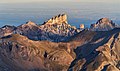
 Northwest aspect | |
| Highest point | |
| Elevation | 13,144 ft (4,006 m) [1] |
| Prominence | 464 ft (141 m) [1] |
| Parent peak | Fortress Peak (13,241 ft) [2] |
| Isolation | 1.52 mi (2.45 km) [2] |
| Coordinates | 38°07′09″N107°32′08″W / 38.1191433°N 107.5355828°W [3] |
| Naming | |
| Etymology | Precipice |
| Geography | |
 Precipice Peak Location in Colorado  Precipice Peak Precipice Peak (the United States) | |
| Location | Hinsdale County Colorado, US |
| Parent range | Rocky Mountains San Juan Mountains |
| Topo map | USGS Wetterhorn Peak |
| Climbing | |
| Easiest route | class 2+ [2] W slope, south ridge [4] |
Precipice Peak is a 13,144-foot-elevation (4,006-meter) mountain summit located in Hinsdale County, of Colorado, United States. [3] It is situated 10.5 miles northeast of the community of Ouray, in the Uncompahgre Wilderness, on land managed by Uncompahgre National Forest. It is part of the San Juan Mountains which is a subset of the Rocky Mountains, and is situated west of the Continental Divide. Topographic relief is significant as the west aspect rises 2,500 feet (760 meters) above the West Fork Cimarron River valley in approximately one mile. Neighbors include Dunsinane Mountain three-quarters of a mile north, Courthouse Mountain 2.4 miles northwest, and Redcliff 2.2 miles south. The mountain's name was officially adopted by the United States Board on Geographic Names in 1966. [3] It is so named because of a very prominent precipice on the mountain's east face. [5]