
Northern Province is one of Zambia's ten provinces. It covers approximately one-sixth of Zambia in land area. The provincial capital is Kasama. The province is made up of 12 districts, namely Kasama District, Chilubi District, Kaputa District, Luwingu District, Mbala District, Mporokoso District, Mpulungu District, Mungwi District, Nsama District, Lupososhi District, Lunte District and Senga Hill District. Currently, only Kasama and Mbala have attained municipal council status, while the rest are still district councils. It is widely considered to be the heartland of the Bemba, one of the largest tribes in Zambia.

Eastern Province is one of Zambia's ten provinces. The province lies between the Luangwa River and borders with Malawi to the east and Mozambique to the south, from Isoka in the northeast to the north of Luangwa in the south. The provincial capital is Chipata. Eastern province has an area of 51,476 km2 (19,875 sq mi), locally shares border with three other provinces of the country and is divided into fifteen districts.

The ten provinces of Zambia are divided into a total of 116 districts as of 2018.
Zambia has several major indigenous languages, all members of the Bantu family, as well as Khwedam, Zambian Sign Language, several immigrant languages and the pidgins Settla and Fanagalo. English is the official language and the major language of business and education.
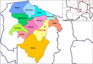
Chinsali is a town in Zambia, which is both the district headquarters of Chinsali District and provincial headquarters of Muchinga Province.

Chama District with the headquarters at Chama is the largest district of the Eastern Province in Zambia and includes a large wilderness in the Upper Luangwa valley just north-east of the North Luangwa National Park. It is made up of two constituencies, namely Chama North and Chama South.

Chinsali District with headquarters at Chinsali is located in Muchinga Province, Zambia.
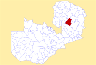
Serenje District is a district of Zambia, located in Central Province. The capital lies at Serenje. As of the 2022 Zambian Census, the district had a population of 158,192 people. It consists of two constituencies, namely Serenje and Muchinga. The district contains Lake Lusiwasi.

Isoka District is a district of Zambia, located in Muchinga Province. The capital lies at Isoka. As of the 2022 Zambian Census, the district had a population of 111,599 people.
Mpika District is a district of Zambia, located in Muchinga Province. The capital lies at Mpika. As of the 2022 Zambian Census, the district had a population of 149,063 people. With the Luangwa River forming its eastern border, it has most of the South Luangwa National Park within its boundaries. It also contains the North Luangwa National Park.

Nakonde District is a district of Zambia, located in Muchinga Province. The capital lies at Nakonde. As of the 2022 Zambian Census, the district had a population of 178,788 people.

Muchinga Province is one of the ten provinces of Zambia. It is located in the northeast of the country and borders with Tanzania in the north, Malawi in the east, Eastern Province in the south, Central Province in the southwest, Luapula Province in the west, and Northern Province in the northwest. The administrative center of the province is Chinsali.

Mafinga District is one of the eight districts of Muchinga Province in Zambia. The district headquarters is at Thendere. It also contains the town of Muyombe. It was named after the Mafinga Hills. As of the 2022 Zambian Census, the district had a population of 102,533 people.
Chilonga is a town in Mpika District in the Muchinga Province of Zambia.
Nakonde is a town in the Muchinga Province of Zambia, on the border with Tanzania. It is at the northern end of Zambia's Great North Road. It is the principal commercial and political headquarters of Nakonde District and the district headquarters are located here.

Chitambo District is a district of Central Province, Zambia. It was separated from Serenje District in 2012 and is located some 357km north-east of Kabwe along the Great North Road. As of the 2022 Zambian Census, the district had a population of 100,603 people.

Chilanga District is a district of Lusaka Province, Zambia. The capital of the district is Chilanga. It was separated from Kafue District in 2012. As of the 2022 Zambian Census, the district had a population of 225,276 people.

Shibuyunji District, also known as Sibuyunji District, is a district of Central Province, Zambia. As of the 2022 Zambian Census, the district had a population of 91,616 people.
Kanchibiya District is a district of Muchinga Province, Zambia. It was separated from Mpika District in 2017. As of the 2022 Zambian Census, the district had a population of 93,052 people.

Lavushimanda District is a district of Muchinga Province, Zambia. It was named after the Lavushi Manda National Park and separated from Mpika District in 2017. It also contains a town centre of the same name on the Great North Road. As of the 2022 Zambian Census, the district had a population of 55,755 people.
