
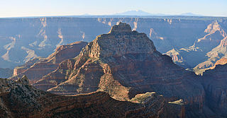
Zoroaster Temple is a 7,123-foot-elevation (2,171-meter) summit located in the Grand Canyon, in Coconino County of Arizona, USA. It is situated 5.5 miles (8.9 km) northeast of the Yavapai Point overlook on the canyon's South Rim, from which it can be seen towering over 4,600 feet above the Colorado River and Granite Gorge. Its nearest higher neighbor is Brahma Temple, less than one mile to the north-northeast. Zoroaster Temple is named for Zoroaster, an ancient Iranian prophet. This name was used by George Wharton James and Clarence Dutton. Dutton began the tradition of naming geographical features in the Grand Canyon after mythological deities. This geographical feature's name was officially adopted in 1906 by the U.S. Board on Geographic Names.
Vishnu Temple is a 7,533-foot-elevation (2,296-meter) summit located in the Grand Canyon, in Coconino County of Arizona, US.

Wotans Throne is a 7,721-foot-elevation (2,353-meter) summit located in the Grand Canyon, in Coconino County, Arizona, US. It is situated one mile immediately southwest of the Cape Royal overlook on the canyon's North Rim, 1.7 miles west-southwest of Freya Castle, two miles west-northwest of Vishnu Temple, and five miles east of Zoroaster Temple. It rises 5,200 feet above the Colorado River.

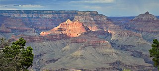
Shiva Temple is a 7,646-foot-elevation (2,331-meter) summit located in the Grand Canyon, in Coconino County of Arizona, US. It is situated six miles north of Hopi Point overlook of the canyon's South Rim, about 2.5 miles southwest of North Rim's Tiyo Point, and two miles northwest of Isis Temple, where it towers 5,200 feet above the Colorado River. Shiva Temple is named for Shiva, the Hindu deity, destroyer of the universe. This name was applied by Clarence Dutton who began the tradition of naming geographical features in the Grand Canyon after mythological deities. Dutton believed Shiva Temple was the largest, grandest, and most majestic of the Grand Canyon buttes, with a broad, level, forested top. This mountain's name was officially adopted in 1906 by the U.S. Board on Geographic Names.
Angels Gate is a 6,761-foot (2,061 m)-elevation summit located in the Grand Canyon, in Coconino County of Arizona, United States. It is situated seven miles (11 km) due north of the Grandview Point overlook on the canyon's South Rim, three miles (4.8 km) west of Vishnu Temple, and three point five miles (5.6 km) southeast of Zoroaster Temple. Topographic relief is significant as it rises over 4,200 feet (1,300 m) above the Colorado River in three miles. Angels Gate is the place in Paiute mythology where the gods would return to Earth by descending from the shadow world above.

Buddha Temple is a 7,212-foot-elevation (2,198-meter) summit located in the Grand Canyon, in Coconino County of northern Arizona, in the Southwestern United States. It is situated 6.5 miles (10.5 km) due north of the Mather Point overlook on the canyon's South Rim, and four miles southwest of the North Rim's Bright Angel Point. Topographic relief is significant as it rises over 3,800 feet in two miles above Bright Angel Canyon to the east, and 3,000 feet in less than one mile above Haunted Canyon to the immediate west. Its neighbors include Manu Temple 1.5 miles (2.4 km) to the northeast, Isis Temple 2.3 miles to the southwest, Zoroaster Temple 3.8 miles to the southeast, and Deva Temple, 3.5 miles to the east. Buddha Temple was named by Henry Gannett, a geographer for Clarence Dutton, in following Dutton's practice of naming features in the Grand Canyon after mythological deities, in this case Buddha. This geographical feature's name was officially adopted in 1906 by the U.S. Board on Geographic Names. The first ascent of this butte was made in 1973 by Bruce Grubbs, Chauncey Parker, and Mark Brown via the Northwest Arete. According to the Köppen climate classification system, Buddha Temple is located in a Cold semi-arid climate zone.

Deva Temple is a 7,353-foot-elevation (2,241-meter) summit located in the Grand Canyon, in Coconino County of northern Arizona, USA. It is situated three miles south of the North Rim's Bright Angel Point, and towers 3,700 feet above Bright Angel Canyon. Its nearest higher neighbor is Brahma Temple, 1.5 mile to the south. Other neighbors include Zoroaster Temple 2.5 miles to the south-southwest, Manu Temple three miles to the west-northwest, and Buddha Temple, 3.5 miles to the west. Deva Temple was named by Henry Gannett, a geographer for Clarence Dutton, in following Dutton's practice of naming features in the Grand Canyon after mythological deities, in this case, Deva. This geographical feature's name was officially adopted in 1906 by the U.S. Board on Geographic Names. According to the Köppen climate classification system, Deva Temple is located in a Cold semi-arid climate zone.

Mount Huethawali is a 6,281-foot-elevation (1,914-meter) summit located in the Grand Canyon, in Coconino County of northern Arizona, US. It is situated 3.5 miles due east of Explorers Monument, 1.5 mile west of Grand Scenic Divide, and immediately southwest of Huxley Terrace. Surrounded by Garnet, Evolution, and Bass Canyons, Huethawali rises over 800 feet above Darwin Plateau, and over 4,000 feet higher than the nearby Colorado River.

Coronado Butte is a 7,162-foot (2,183 m)-elevation summit located in the Grand Canyon, in Coconino County of Arizona, United States. It is situated one mile (1.6 km) west of the Moran Point overlook on the canyon's South Rim, and one mile northeast of Sinking Ship, its nearest higher neighbor. Topographic relief is significant as this butte rises 4,600 feet (1,400 m) above the Colorado River in 2.5 miles (4.0 km). Coronado Butte is named for Francisco Vázquez de Coronado (1510–1554), the explorer whose 1540 expedition was the first European sighting of the Grand Canyon, among other landmarks. This geographical feature's name was officially adopted in 1906 by the U.S. Board on Geographic Names. The first ascent was made by John Hance and tourist prior to 1900, in the 1890s. According to the Köppen climate classification system, Coronado Butte is located in a cold semi-arid climate zone.

Chuar Butte is a prominent 6,500-foot-elevation (2,000-meter) summit located in the Grand Canyon, in Coconino County of northern Arizona, US. It is situated 1.5 miles northwest of Cape Solitude on the canyon's East Rim, three miles southeast of Gunther Castle, and immediately west of the confluence of the Colorado River and Little Colorado River. This position also places it where Marble Canyon ends, and the Grand Canyon begins. Topographic relief is significant as it rises nearly 3,800 feet above the river in less than one mile. According to the Köppen climate classification system, Chuar Butte is located in a cold semi-arid climate zone.

Comanche Point is a 7,073-foot-elevation (2,156-meter) summit located in the Grand Canyon, in Coconino County of northern Arizona, US. Part of the Palisades of the Desert, Comanche Point is the high point on the canyon's less-visited East Rim, and is four miles north-northeast of Desert View Point, its nearest higher neighbor. Topographic relief is significant as it towers 4,400 feet above the Colorado River in 1.5 mile. Comanche Point was named in 1900 by George Wharton James for the Comanche, a Native-American nation from the Great Plains, in keeping with a practice of naming the points on the canyon's South Rim for Native American nations. This geographical feature's name was officially adopted in 1906 by the U.S. Board on Geographic Names. According to the Köppen climate classification system, Comanche Point is located in a Cold semi-arid climate zone. On September 27, 1994, the tabloid Weekly World News ran an outlandish cover story that wreckage of a 4000-year-old UFO had been found in limestone rubble near the base of Comanche Point.

Brady Peak is an 8,121-foot (2,475 m)-elevation summit located in the Grand Canyon, in Coconino County of northern Arizona, United States. It is situated one mile (1.6 km) northeast of the Vista Encantada viewpoint on the canyon's North Rim, where it towers 4,800 feet (1,500 m) above the bottom of Nankoweap Canyon. Its nearest higher neighbor is Mount Hayden, two miles (3.2 km) to the north, Kibbey Butte is one mile to northwest, and Alsap Butte lies one mile to the northeast. Brady Peak is named after Peter Rainsford Brady (1825–1902), a pioneer and politician of the Arizona Territory. This geographical feature's name was officially adopted in 1932 by the U.S. Board on Geographic Names. According to the Köppen climate classification system, Brady Peak is located in a cold semi-arid climate zone.

Confucius Temple is a 7,081-foot-elevation (2,158-meter) summit located in the Grand Canyon, in Coconino County of northern Arizona, US. It is situated 1.5 mile southeast of Point Sublime, four miles west-northwest of Shiva Temple, and three miles northwest of Tower of Ra, where it rises over 3,200 feet above Hindu Amphitheater. Confucius Temple is named for Confucius, the Chinese philosopher. This name was applied by Clarence Dutton, who began the tradition of naming geographical features in the Grand Canyon after mythological deities. Confucius Temple is one of the Twin Buttes in the Grand Canyon, the other being Mencius Temple (7,001 ft), which is named for Mencius, considered the second-most famous sage, after only Confucius himself. This mountain's name was officially adopted in 1906 by the U.S. Board on Geographic Names. According to the Köppen climate classification system, Confucius Temple has a Cold semi-arid climate.

Pollux Temple is a 6,251-foot-elevation (1,905-meter) summit in the Grand Canyon, in Coconino County of northern Arizona, US. It is situated ten miles northwest of Grand Canyon Village, and less than one mile northeast of Jicarilla Point. Castor Temple is one mile northwest, and Diana Temple is one mile southeast. Topographic relief is significant as Pollux Temple rises nearly 4,000 feet above the Colorado River in less than two miles. Pollux Temple is named for Pollux, the divine son of Zeus according to Greek mythology. Clarence Dutton began the practice of naming geographical features in the Grand Canyon after mythological deities. According to the Köppen climate classification system, Pollux Temple is located in a Cold semi-arid climate zone.

Diana Temple is a 6,683-foot-elevation (2,037-meter) summit located in the Grand Canyon, in Coconino County of northern Arizona, US. It is situated nine miles northwest of Grand Canyon Village, and immediately northeast of Mescalero Point. Pollux Temple is one mile northwest, Marsh Butte one mile east-northeast, and Vesta Temple is one mile south. Topographic relief is significant as Diana Temple rises nearly 4,300 feet above the Colorado River in less than two miles. Diana Temple is named for Diana, the goddess of the hunt and the moon according to Roman mythology. Clarence Dutton began the practice of naming geographical features in the Grand Canyon after mythological deities. The U.S. Geological Survey applied the name, and this geographical feature's name was officially adopted in 1908 by the U.S. Board on Geographic Names. In the early 1900s this mesa was sometimes called "No Mans Land". According to the Köppen climate classification system, Diana Temple is located in a Cold semi-arid climate zone.

Manu Temple is a 7,184-foot-elevation (2,190-meter) summit located in the Grand Canyon, in Coconino County of northern Arizona, United States. It is situated one mile south of the North Rim's Widforss Point, 1.5 miles (2.4 km) northeast of parent Buddha Temple, and three miles southwest of the North Rim's Bright Angel Point. Topographic relief is significant as it rises nearly 3,600 feet in two miles above Bright Angel Canyon to the east, and 2,200 feet in less than one mile above Haunted Canyon to the immediate west. Its neighbors include Brahma Temple and Deva Temple to the east on the opposite side of Bright Angel Canyon. From the South Rim of the canyon it may be difficult to discern Manu Temple from the walls of the Kaibab Plateau one mile behind it, but when the lighting and atmosphere are favorable, this butte of great proportions can be seen clearly defined.

Vesta Temple is a 6,299-foot-elevation (1,920-meter) summit located in the Grand Canyon, in Coconino County of northern Arizona, US. It is situated eight miles west-northwest of Grand Canyon Village, and immediately northeast of Mimbreno Point. Marsh Butte is one mile northeast, Eremita Mesa immediately southeast, and nearest higher neighbor Diana Temple is one mile north. Topographic relief is significant as Vesta Temple rises 3,900 feet above the Colorado River in 2.5 miles. Vesta Temple is named for Vesta, the goddess of the hearth, home, and family according to Roman mythology. Clarence Dutton began the practice of naming geographical features in the Grand Canyon after mythological deities. This geographical feature's toponym was officially adopted in 1908 by the U.S. Board on Geographic Names. According to the Köppen climate classification system, Vesta Temple is located in a Cold semi-arid climate zone.

Castor is a 6,221-foot-elevation (1,896-meter) summit located in the Grand Canyon, in Coconino County of northern Arizona, United States. It is situated 11 miles west-northwest of Grand Canyon Village, and less than one mile north of Piute Point. Pollux Temple is one mile southeast, and Geikie Peak is three miles to the east. Topographic relief is significant as Castor Temple rises over 3,800 feet above the Colorado River in two miles.

Sinking Ship is a 7,344-foot (2,238 m) elevation summit located in the Grand Canyon, in Coconino County of northern Arizona, United States. This butte is situated 1.7 miles (2.7 km) southeast of the Grandview Point overlook on the canyon's South Rim, and 1.25 miles (2.01 km) southwest of Coronado Butte. Topographic relief is significant as it rises 4,800 feet (1,500 m) above the Colorado River in 4 miles (6.4 km). According to the Köppen climate classification system, Sinking Ship is located in a cold semi-arid climate zone.

Masonic Temple is a 6,242-foot-elevation (1,903-meter) summit located in the Grand Canyon, in Coconino County of northern Arizona, US. Set below Dutton Point on the Powell Plateau, and overlooking the Shinumo Amphitheater, it is situated three miles west of Holy Grail Temple, 2.7 miles northwest of Dox Castle, and 1.6 miles north-northeast of Fan Island. Topographic relief is significant as it rises 4,000 feet above the Colorado River in four miles (6.4 km). According to the Köppen climate classification system, Masonic Temple is located in a cold semi-arid climate zone, with precipitation runoff draining south to the Colorado River via Hakatai Canyon from the west aspect, Burro Canyon from the south aspect, and Muav Canyon from the east aspect. This butte is an erosional remnant composed of strata of the Pennsylvanian-Permian Supai Group overlaying the conspicuous cliffs of Mississippian Redwall Limestone, in turn overlaying the Cambrian Tonto Group.


