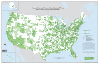
In the United States, a metropolitan statistical area (MSA) is a geographical region with a relatively high population density at its core and close economic ties throughout the region. Such regions are not legally incorporated as a city or town would be and are not legal administrative divisions like counties or separate entities such as states. That makes the precise definition of any given metropolitan area vary with the source. The statistical criteria for a standard metropolitan area were defined in 1949 and redefined as a metropolitan statistical area in 1983.

Logan County is a county located in the U.S. state of Colorado. As of the 2020 census, the population was 21,528. The county seat is Sterling. The county was named for General John A. Logan.

The Town of Iliff is a Statutory Town located in Logan County, Colorado, United States. The population was 246 at the 2020 United States Census.

The Blacksburg-Christiansburg Metropolitan Statistical Area, formerly the Blacksburg-Christiansburg-Radford Metropolitan Statistical Area, is a Metropolitan Statistical Area (MSA) as defined by the United States Office of Management and Budget (OMB) located in the New River Valley of Southwest Virginia. As of the 2020 census, the MSA had a population of 181,863.

The Colorado Springs, CO, Metropolitan Statistical Area is a United States Office of Management and Budget defined Metropolitan Statistical Area (MSA) located in the Colorado Springs region of the State of Colorado. The 2020 United States census counted a population of 755,105, an increase of 17.0% since the 2010 United States Census. The Colorado Springs MSA is the 79th-most populous MSA in the United States. The Colorado Springs MSA encompasses El Paso County and Teller County, Colorado. Approximately 88.40% percent of the MSA's population live in cities or CDPs. The Colorado Springs Metropolitan Statistical Area is the second-most populous component of the Front Range Urban Corridor.

The United States Office of Management and Budget has defined the 12-county Denver–Aurora, CO Combined Statistical Area comprising the Denver–Aurora–Lakewood, CO Metropolitan Statistical Area, the Boulder, CO Metropolitan Statistical Area, and the Greeley, CO Metropolitan Statistical Area. The United States Census Bureau estimates that the population was 3,214,218 as of July 1, 2012, an increase of +3.99% since the 2010 United States Census, and ranking as the 16th most populous metropolitan combined statistical area and the 17th most populous primary statistical area of the United States. The population estimate for 2020 was 3,652,385.
The Durango Micropolitan Statistical Area is a United States Census Bureau defined Micropolitan Statistical Area located in the Durango area of the State of Colorado. The Durango Micropolitan Statistical Area is defined as La Plata County, Colorado. The Micropolitan Statistical Area had a population of 43,941 at the 2000 Census. A July 1, 2009 U.S. Census Bureau estimate placed the population at 51,464.

The Montrose Micropolitan Statistical Area is a United States Census Bureau defined Micropolitan Statistical Area located in the Montrose area of the State of Colorado. The Montrose Micropolitan Statistical Area is defined as Montrose County, Colorado. The Micropolitan Statistical Area had a population of 33,432 at the 2000 Census. A July 1, 2009 U.S. Census Bureau estimate placed the population at 41,412.

The Fort Morgan Micropolitan Statistical Area is a United States Census Bureau defined Micropolitan Statistical Area located in the Fort Morgan area of the State of Colorado. The Fort Morgan Micropolitan Statistical Area is defined as Morgan County, Colorado. The Micropolitan Statistical Area had a population of 27,171 at the 2000 Census. A July 1, 2009 U.S. Census Bureau estimate placed the population at 27,850.

The Silverthorne Micropolitan Statistical Area is a United States Census Bureau defined Micropolitan Statistical Area located in the Silverthorne area of the State of Colorado. The Silverthorne Micropolitan Statistical Area is defined as Summit County, Colorado. The Micropolitan Statistical Area had a population of 23,548 at the 2000 Census. A July 1, 2009 U.S. Census Bureau estimate placed the population at 27,239.
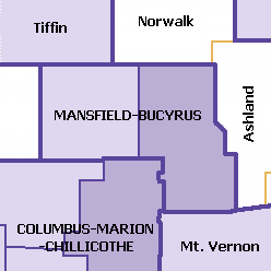
The Mansfield–Bucyrus, OH Combined Statistical Area is a CSA in the U.S. state of Ohio, as defined by the United States Census Bureau. It consists of the Mansfield Metropolitan Statistical Area ; and the Bucyrus Micropolitan Statistical Area. As of the 2000 Census, the Combined Statistical Area had a population of 175,818, but according to a US Census 2009 estimate, the CSA has a population of 167,893 residents.
The Salisbury, MD-DE Metropolitan Statistical Area is a United States Census Bureau-designated metropolitan area centered in and around Salisbury, Maryland, including four counties: Somerset, Wicomico, and Worcester in Maryland; and Sussex in Delaware.

The city of Portland, Maine, is the hub city of a metropolitan area in southern Maine, United States. The region is commonly known as Greater Portland or the Portland metropolitan area. For statistical purposes, the U.S. federal government defines three different representations of the Portland metropolitan area. The Portland–South Portland–Biddeford, Maine, metropolitan statistical area is a region consisting of three counties in Maine, anchored by the city of Portland and the smaller cities of South Portland and Biddeford. As of the 2010 census, the MSA had a population of 514,098. A larger combined statistical area (CSA), the Portland–Lewiston–South Portland combined statistical area, is defined as the combination of this metropolitan statistical area (MSA) with the adjacent Lewiston–Auburn MSA. The CSA comprises four counties in southern Maine. The Portland–South Portland metropolitan New England city and town area is defined on the basis of cities and towns rather than entire counties. It consists of most of Cumberland and York counties plus the town of Durham in Androscoggin County. The Greater Portland area has emerged as an important center for the creative economy, which is also bringing gentrification.

The Mount Sterling Micropolitan Statistical Area, as defined by the United States Census Bureau, is an area consisting of three counties in Kentucky, anchored by the city of Mount Sterling. As of the 2000 census, the μSA had a population of 40,195.

The Martinsville Micropolitan Statistical Area is a United States Micropolitan Statistical Area (USA) in Virginia, as defined by the Office of Management and Budget (OMB) as of June, 2003. As of the 2000 census, the μSA had a population of 73,346.

The Lima metropolitan statistical area, as defined by the United States Census Bureau, is an area consisting of one county – Allen – in Northwest Ohio, anchored by the city of Lima. As of the 2000 census, the MSA had a population of 108,473.

The Mansfield Metropolitan Statistical Area, as defined by the United States Census Bureau, is an area consisting of one county – Richland – in north central Ohio, anchored by the city of Mansfield. As of the 2010 census, the MSA had a population of 124,475.
This article includes information about the 100 most populous incorporated cities, the 100 most populous core-based statistical areas (CBSAs), and the 100 most populous primary statistical areas (PSAs) of the United States and Puerto Rico. This information is displayed in two tables. The first table ranks the cities, CBSAs, and PSAs separately by population. The second table displays the areas in hierarchical order by the most populous PSA, then most populous CBSA, and then most populous city.

This is a population history of the 272 active incorporated municipalities of the US State of Colorado since the 2000 United States census as estimated by the United States Census Bureau.
