| Storm Peak | |
|---|---|
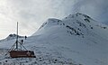
 Northeast aspect | |
| Highest point | |
| Elevation | 13,495 ft (4,113 m) [1] [2] |
| Prominence | 620 ft (189 m) [2] |
| Parent peak | Tower Mountain (13,558 ft) [2] |
| Isolation | 1.37 mi (2.20 km) [2] |
| Coordinates | 37°51′34″N107°38′51″W / 37.8594787°N 107.6475072°W [3] |
| Geography | |
 Storm Peak Location in Colorado  Storm Peak Storm Peak (the United States) | |
| Country | United States |
| State | Colorado |
| County | San Juan |
| Parent range | Rocky Mountains San Juan Mountains [4] |
| Topo map | USGS Silverton |
| Climbing | |
| Easiest route | class 3 scrambling [2] |
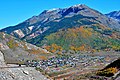
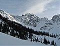
Storm Peak is a 13,495-foot-elevation (4,113-meter) summit located in San Juan County, Colorado, United States.