
Sunshine Peak is a fourteen thousand foot mountain peak in the U.S. state of Colorado. It is located in the San Juan Mountains in Hinsdale County approximately 9 miles (14 km) south west of Lake City, and about 1 mile (1.6 km) south of Redcloud Peak. It rises on the north side of the Lake Fork of the Gunnison River.

Sharkstooth Peak is a 12,468-foot-elevation (3,800-meter) mountain summit in Montezuma County, Colorado.
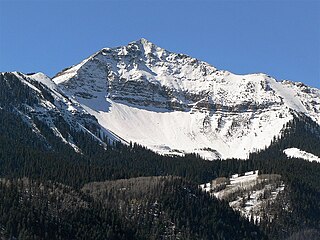
Sunshine Mountain is a 12,930-foot-elevation (3,940-meter) mountain summit located in San Miguel County, in Colorado, United States. It is situated nine miles southwest of the community of Telluride, in the Lizard Head Wilderness, on land managed by Uncompahgre National Forest. It is part of the San Juan Mountains which is a subset of the Rocky Mountains. Sunshine Mountain is situated 24 miles west of the Continental Divide, 2.75 miles east of Wilson Peak, and 1.8 mile northeast of Lizard Head, the nearest higher neighbor. Topographic relief is significant as the west aspect rises 2,700 feet above Bilk Creek in approximately one mile. The mountain is composed of rock of the San Juan Formation overlaying Telluride Conglomerate, in turn overlaying Mancos Shale. The mountain's name, which has been officially adopted by the United States Board on Geographic Names, was in use before 1899 when Henry Gannett published it in A Dictionary of Altitudes in the United States.
Coxcomb Peak is a 13,656-foot-elevation (4,162-meter) mountain summit located on the common boundary of Hinsdale County and Ouray County, in Colorado, United States. It is situated nine miles northeast of the community of Ouray, in the Uncompahgre Wilderness, on land managed by Uncompahgre National Forest. It is part of the San Juan Mountains which are a subset of the Rocky Mountains, and is situated west of the Continental Divide. Coxcomb ranks as the 171st-highest peak in Colorado, and topographic relief is significant as the south aspect rises 2,000 feet above Wetterhorn Basin in approximately one mile, and 4,400 feet above Cow Creek in three miles. Neighbors include Precipice Peak 2.7 miles to the north, Redcliff one-half mile north, Matterhorn Peak 2.3 miles to the east-southeast, and nearest higher neighbor Wetterhorn Peak 1.8 mile to the southeast. The mountain's descriptive name, which has been officially adopted by the United States Board on Geographic Names, was in use since at least 1906 when Henry Gannett published it in the Gazetteer of Colorado.

Darley Mountain is a 13,260-foot-elevation (4,042 meter) mountain summit located on the shared boundary of Hinsdale County with Ouray County, in southwest Colorado, United States. It is situated five miles southeast of the community of Ouray, in the Uncompahgre Wilderness, on land managed by Uncompahgre National Forest. It is part of the San Juan Mountains which are a subset of the Rocky Mountains, and is west of the Continental Divide. Neighboring geographic features include Engineer Pass 0.6 mile to the southeast, Engineer Mountain 0.9 mile to the south, and nearest higher neighbor Wildhorse Peak 2.2 miles to the north. The mountain's name was officially adopted in 1992 by the United States Board on Geographic Names to commemorate George Marshall Darley (1847–1917), pioneering minister of the San Juan Mountains, who founded and built the first church in western Colorado in Lake City in 1876. Lake City is approximately 16 miles east of this mountain.
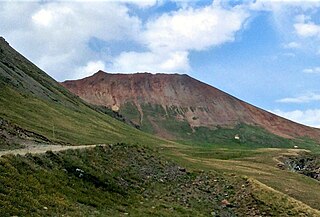
American Peak is a 13,806-foot-elevation (4,208-meter) mountain summit located in Hinsdale County, of southwest Colorado, United States.

Dunsinane Mountain, or officially Dunsinane, is a 12,742-foot-elevation (3,884-meter) mountain summit located in Hinsdale County, of Colorado, United States. It is situated 11 miles east of the community of Ridgway, in the Uncompahgre Wilderness, on land managed by Uncompahgre National Forest. It is part of the San Juan Mountains which are a subset of the Rocky Mountains, and is situated west of the Continental Divide. Topographic relief is significant as the east aspect rises 2,500 feet above the Middle Fork Cimarron River valley in approximately one mile. The mountain's name was officially adopted as Dunsinane by the United States Board on Geographic Names in 1966, and is so named because it resembles the castle Dunsinane of Shakespeare's Macbeth.

Gravel Mountain is a 13,596-foot-elevation (4,144-meter) summit in Hinsdale County, Colorado, United States. It is located nine miles (14 km) southeast of the community of Ouray, on land administered by the Bureau of Land Management. It is situated eight miles (13 km) west of the Continental Divide in the San Juan Mountains which are a subrange of the Rocky Mountains. Precipitation runoff from the mountain drains into Henson Creek which is part of the Gunnison River watershed. Topographic relief is significant as the summit rises 2,800 feet above Henson Creek in approximately one mile (1.6 km). Access to the mountain is via the Alpine Loop Back Country Byway. The mountain's toponym has been officially adopted by the United States Board on Geographic Names, and has been recorded in publications since at least 1906.

Carson Peak is a 13,662-foot-elevation (4,164-meter) summit in Hinsdale County, Colorado, United States.
Proposal Peak is a 13,339-foot-elevation (4,066-meter) mountain summit located in San Juan County, Colorado, United States.

Emery Peak is a 13,321-foot-elevation (4,060-meter) summit located in San Juan County, Colorado, United States.

Cinnamon Mountain is a 13,336-foot-elevation (4,065-meter) summit in San Juan County, Colorado, United States.

Engineer Mountain is a 13,225-foot-elevation (4,031 meter) summit located on the boundary shared by Hinsdale County with Ouray County, in Colorado, United States.

Whitecross Mountain is a 13,553-foot-elevation (4,131-meter) summit in Hinsdale County, Colorado, United States.

Little Giant Peak is a 13,417-foot-elevation (4,090-meter) mountain summit in San Juan County, Colorado, United States.

Storm Peak is a 13,495-foot-elevation (4,113-meter) summit located in San Juan County, Colorado, United States.

Dome Mountain is a 13,379-foot-elevation (4,078-meter) summit located in San Juan County, Colorado, United States.
Wood Mountain is a 13,682-foot-elevation (4,170 meter) summit located on the boundary shared by Hinsdale County with San Juan County, in Colorado, United States.

Bristol Head is a 12,712-foot-elevation (3,875-meter) mountain summit in Mineral County, Colorado, United States.

Cascade Mountain is a 12,326-foot-elevation (3,757-meter) mountain summit in Grand County, Colorado, United States.


