Tidewater region

Last updated
The Tidewater region location Tidewater region - Location.svg
The Tidewater region location
The Tidewater region is the easternmost (dark green) region. Virginia painted relief.png
The Tidewater region is the easternmost (dark green) region.

The Tidewater region is a region of lowlaying plains of southeast Virginia and northeastern North Carolina, part of the Atlantic coastal plain in the United States of America. Portions of Maryland facing the Chesapeake Bay are also given this designation. [1] The area gains its name because of the effects of the changing tides on local rivers, sounds, and the ocean. The area is generally flat and low and composed of tidal marsh and large expanses of swamp. Much of the area is covered with pocosin and the higher areas are used for agricultural farmlands. Geographically, in North Carolina and Virginia the Tidewater area is the land between the Suffolk Scarp and the Atlantic Ocean. The Hampton Roads area of Virginia is considered to be in the Tidewater. Extreme Southern Maryland [2] and parts of the lower Eastern Shore round out the northern fringe of the region on the Chesapeake Bay.

Virginia State of the United States of America

Virginia, officially the Commonwealth of Virginia, is a state in the Southeastern and Mid-Atlantic regions of the United States located between the Atlantic Coast and the Appalachian Mountains. Virginia is nicknamed the "Old Dominion" due to its status as the first English colonial possession established in mainland North America and "Mother of Presidents" because eight U.S. presidents were born there, more than any other state. The geography and climate of the Commonwealth are shaped by the Blue Ridge Mountains and the Chesapeake Bay, which provide habitat for much of its flora and fauna. The capital of the Commonwealth is Richmond; Virginia Beach is the most populous city, and Fairfax County is the most populous political subdivision. The Commonwealth's estimated population as of 2017 is over 8.4 million.

North Carolina State of the United States of America

North Carolina is a state in the southeastern region of the United States. It borders South Carolina and Georgia to the south, Tennessee to the west, Virginia to the north, and the Atlantic Ocean to the east. North Carolina is the 28th-most extensive and the 9th-most populous of the U.S. states. The state is divided into 100 counties. The capital is Raleigh, which along with Durham and Chapel Hill is home to the largest research park in the United States. The most populous municipality is Charlotte, which is the second-largest banking center in the United States after New York City.

Atlantic coastal plain physiographic region along the East Coast of the United States

The Atlantic coastal plain is a physiographic region of low relief along the East Coast of the United States. It extends 2,200 miles (3,500 km) from the New York Bight southward to a Georgia/Florida section of the Eastern Continental Divide, which demarcates the plain from the ACF River Basin in the Gulf Coastal Plain to the west. The province is bordered on the west by the Atlantic Seaboard fall line and the Piedmont plateau, to the east by the Atlantic Ocean, and to the south by the Floridian province. The Outer Lands archipelagic region forms the insular northeasternmost extension of the Atlantic coastal plain.

The term tidewater may be correctly applied to all portions of any area, including Virginia, where the water level is affected by the tides (more specifically, where the water level rises when the tide comes in). In the case of Virginia, the Tidewater region includes the land east of the Fall Line, the natural border with the Piedmont Region. It includes Hampton Roads, the rest of the Virginia Peninsula, the Middle Peninsula, the Northern Neck, and the Eastern Shore.

Atlantic Seaboard fall line escarpment in the Eastern United States

The Atlantic Seaboard Fall Line, or Fall Zone, is a 900-mile (1,400 km) escarpment where the Piedmont and Atlantic coastal plain meet in the eastern United States. Much of the Atlantic Seaboard fall line passes through areas where no evidence of faulting is present.

Hampton Roads Metropolitan area in the United States

Hampton Roads is the name of both a body of water that serves as a wide channel for the James, Nansemond and Elizabeth rivers between Old Point Comfort and Sewell's Point where the Chesapeake Bay flows into the Atlantic Ocean and the surrounding metropolitan region located in the Southeastern Virginia and Northeastern North Carolina portions of the Tidewater region.

Virginia Peninsula

The Virginia Peninsula is a peninsula in southeast Virginia, USA, bounded by the York River, James River, Hampton Roads and Chesapeake Bay. It is sometimes known as the Lower Peninsula to distinguish it from two other peninsulas to the north, the Middle Peninsula and the Northern Neck.

Planters in the early American colonies extended their tobacco productions above the Fall Line, where waterfalls or rapids mark the end of the Tidewater and the beginning of the foothill region known as the Piedmont.[ citation needed ]

Piedmont (United States) plateau region located in the eastern United States

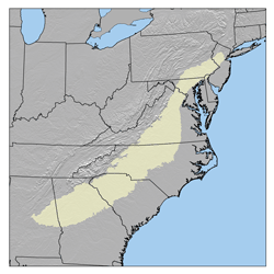
The Piedmont is a plateau region located in the Eastern United States. It sits between the Atlantic coastal plain and the main Appalachian Mountains, stretching from New Jersey in the north to central Alabama in the south. The Piedmont Province is a physiographic province of the larger Appalachian division which consists of the Gettysburg-Newark Lowlands, the Piedmont Upland and the Piedmont Lowlands sections.

Tidewater is host to flora commonly associated with the South Atlantic pine forests and lower Southeast Coastal Plain maritime flora, the latter found primarily in southeastern Virginia.

See also

Related Research Articles

Chesapeake Bay An estuary in the U.S. states of Maryland and Virginia

The Chesapeake Bay is an estuary in the U.S. states of Maryland and Virginia. The Bay is located in the Mid-Atlantic region and is primarily separated from the Atlantic Ocean by the Delmarva Peninsula with its mouth located between Cape Henry and Cape Charles. With its northern portion in Maryland and the southern part in Virginia, the Chesapeake Bay is a very important feature for the ecology and economy of those two states, as well as others. More than 150 major rivers and streams flow into the Bay's 64,299-square-mile (166,534 km2) drainage basin, which covers parts of six states and all of Washington, D.C.

Delmarva Peninsula peninsula

The Delmarva Peninsula, or simply Delmarva, is a large peninsula on the East Coast of the United States, occupied by Delaware and parts of the Eastern Shores of Maryland and Virginia. The peninsula is 170 miles (274 km) long. In width, it ranges from 70 miles (113 km) near its center, to 12 miles (19 km) at the isthmus on its northern edge, to less near its southern tip of Cape Charles. It is bordered by the Chesapeake Bay on the west, the Delaware River, Delaware Bay, and the Atlantic Ocean on the east, and the Elk River and its isthmus on the north.

Cape Charles, Virginia Town in Commonwealth of Virginia, United States

Cape Charles is a town / municipal corporation in Northampton County, Virginia, United States. The population was 1,009 as of the 2010 U.S.Decennial Census.

Middle Peninsula

The Middle Peninsula is the second of three large peninsulas on the western shore of Chesapeake Bay in Virginia, in the United States. It lies between the Northern Neck and the Virginia Peninsula. This peninsula is bounded by the Rappahannock River on the north and the York River on the south, with the Chesapeake Bay to the east. It encompasses six Virginia counties: Essex, Gloucester, King and Queen, King William, Mathews, and Middlesex. Developed for tobacco plantations in the colonial era, in the 21st century the Middle Peninsula is known for its quiet rural life, vegetable truck-farming, and fishing industry.

U.S. Route 13 highway in the United States

U.S. Route 13 is a north–south U.S. highway established in 1926 that runs for 517 miles (832 km) from Interstate 95 just north of Fayetteville, North Carolina to the northeastern suburbs of Philadelphia, Pennsylvania, in Morrisville. In all, it traverses five states in the Atlantic coastal plain region. It follows the Atlantic coast more closely than does the main north–south U.S. highway of the region, U.S. Route 1. Its routing is largely rural, the notable exceptions being the Hampton Roads area and the northern end of the highway in Delaware and Pennsylvania. It is also notable for being the main thoroughfare for the Delmarva Peninsula and carrying the Chesapeake Bay Bridge–Tunnel to it in Virginia.

Chesapeake Bay Bridge–Tunnel

The Chesapeake Bay Bridge–Tunnel (CBBT) is a 23-mile (37 km) bridge–tunnel crossing at the mouth of the Chesapeake Bay, the Hampton Roads harbor, and nearby mouths of the James and Elizabeth Rivers in the American state of Virginia. It connects Northampton County on the Delmarva Peninsula and Eastern Shore with Virginia Beach, Norfolk, Chesapeake, and Portsmouth on the Western Shore and South side / Tidewater which are part of the Hampton Roads metropolitan area of eight close cities around the harbor's shores and peninsula. The Bridge-Tunnel originally combined 12 miles (19 km) of trestle, two 1-mile-long (1.6 km) tunnels, four artificial islands, four high-level bridges, approximately 2 miles (3.2 km) of causeway, and 5.5 miles (8.9 km) of northeast and southwest approach roads—crossing the Chesapeake Bay and preserving traffic on the Thimble Shoals and Chesapeake dredged shipping channels leading to the Atlantic. It replaced vehicle ferry services that operated from South Hampton Roads and from the Virginia Peninsula since the 1930s. Financed by toll revenue bonds, the Bridge–Tunnel was opened on April 15, 1964, and remains one of only ten bridge–tunnel systems in the world, three of which are located in the water dominated Hampton Roads area of Tidewater Virginia.

South Hampton Roads

South Hampton Roads is a region located in the extreme southeastern portion of Virginia's Tidewater region in the United States with a total population of 1,191,937. It is part of the Virginia Beach-Norfolk-Newport News, VA-NC MSA, which itself has a population of 1,724,876.

Eastern Shore of Maryland region of the state of Maryland, United States of America

The Eastern Shore of Maryland is a part of the U.S. state of Maryland that lies predominantly on the east side of the Chesapeake Bay and consists of nine counties. As of the 2010 census, its population was 449,226, with just under 8 percent of Marylanders living in the region. The term "Eastern Shore" distinguishes a territorial part of the State of Maryland from the Western Shore of Maryland, land west of the Chesapeake Bay.

Maryland's Western Shore is an area of Maryland west of the Chesapeake Bay. Originally, it included all areas not on the Eastern Shore and some colonial and later state government functions were administered separately for each region. The term no longer identifies an official region of Maryland and is used in contrast to the "Eastern Shore", also known as the "Delmarva" peninsula separated from the Maryland northeast corner of mainland with northern Delaware in the north by the Chesapeake and Delaware Canal, heavily used by transiting cargo ships along the major East Coast port cities.

Pencader Hundred is an unincorporated subdivision of New Castle County, Delaware. Hundreds were once used as a basis for representation in the Delaware General Assembly, and while their names still appear on all real estate transactions, they presently have no meaningful use or purpose except as a geographical point of reference. It is named after Pencader, Carmarthenshire, Wales.

Transportation in Virginia

Transportation in the Commonwealth of Virginia is by land, sea and air. Virginia's extensive network of highways and railroads were developed and built over a period almost 400 years, beginning almost immediately after the founding of Jamestown in 1607, and often incorporating old established trails of the Native Americans.

U.S. Route 60 in Virginia highway in Virginia

U.S. Route 60 in Virginia runs 303 miles (488 km) west to east through the central part of the state, generally close to and paralleling the Interstate 64 corridor, except for the crossing of the Blue Ridge Mountains, and in the South Hampton Roads area.

Older Southern American English

Older Southern American English was a set of American English dialects of the Southern United States, primarily spoken by White Southerners up until the American Civil War, moving towards a state of decline by the turn of the nineteenth century, further accelerated after World War II and again, finally, by the Civil Rights Movement. These dialects have since largely given way, on a larger regional level, to a more unified and younger Southern American English, notably recognized today by a unique vowel shift and certain other vocabulary and accent characteristics. Some features unique to older Southern U.S. English persist today, though typically in only very localized dialects or speakers.

Piscataway language language

Piscataway is an extinct Algonquian language formerly spoken by the Piscataway, a dominant chiefdom in southern Maryland on the Western Shore of the Chesapeake Bay at time of contact with English settlers. Piscataway, also known as Conoy, is considered a dialect of Nanticoke.

Environment of Virginia

The natural environment of Virginia encompasses the physical geography and biology of the U.S. state of Virginia. Virginia has a total area of 42,774.2 square miles (110,784.67 km2), including 3,180.13 square miles (8,236.5 km2) of water, making it the 35th-largest state by area. Forests cover 65% of the state, wetlands and water cover 6% of the land in the state, while 5% of the state is a mixture of commercial, residential, and transitional.

Salisbury Embayment

The Salisbury Embayment was an arm of the Atlantic Ocean which covered what is now Delaware, southern and eastern Maryland, the Virginia Peninsula and parts of southern New Jersey during Paleogene and Neogene times, from about 65 million to 5 million years ago. Sea level throughout most of this period stood several hundred feet higher than at present, and deposition of sediments draining off the continent possibly caused the underlying rocks to sink down, creating the embayment. The shore of the embayment lay inland at the present-day Fall Line in the region. Throughout the Paleogene and Neogene times, sediment accumulated on the floor of the Salisbury Embayment during pulses of high sea level, forming the Paleocene Aquia and Brightseat Formations, the Eocene Pamunkey Group, and the Miocene Chesapeake Group. There are no deposits from the Oligocene epoch due to a drop in sea level, however, a 2- to 3- mile diameter meteorite or asteroid is thought to have left a 50-mile diameter crater upon impact in the southern Chesapeake Bay.

References

  1. Boon, John D. (2004). "Tidewater". Secrets of the Tide. Horwood. p. 1. ISBN   1-904275-17-6. Geographically, Tidewater Virginia and Tidewater Maryland together form a triangle whose base extends from the Chesapeake Bay entrance westward through Hampton Roads and the lowlands south of the James River to Petersburg....
  2. "Title unknown". Archived from the original on July 26, 2009.

Coordinates: 36°53′N76°28′W / 36.883°N 76.467°W / 36.883; -76.467

Geographic coordinate system Coordinate system

A geographic coordinate system is a coordinate system that enables every location on Earth to be specified by a set of numbers, letters or symbols. The coordinates are often chosen such that one of the numbers represents a vertical position and two or three of the numbers represent a horizontal position; alternatively, a geographic position may be expressed in a combined three-dimensional Cartesian vector. A common choice of coordinates is latitude, longitude and elevation. To specify a location on a plane requires a map projection.