Tunney's Pasture

Last updated

An aerial view of Tunney's Pasture in 2022, with the construction of the new central heating plant in the foreground TunneysPasture2022.jpg
An aerial view of Tunney's Pasture in 2022, with the construction of the new central heating plant in the foreground

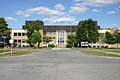
Tunney's Pasture is a 49-hectare (121-acre) campus in the Canadian capital of Ottawa, Ontario, that is exclusively developed for federal government buildings. It is bordered by Scott Street to the south, Parkdale Avenue to the east, the Kichi Zibi Mikan to the north, and the Champlain Park neighbourhood to the west. While strictly speaking it is confined to this area, people living in the vicinity of it will often call the wider neighbourhood Tunney's Pasture.

Contents

The complex is served by Tunney's Pasture station, a stop on the Transitway bus rapid transit system and the western terminus on the Confederation Line of Ottawa's O-Train light rail system.

History

Before development, this area, officially known as "Lot 35, Concession A, Township of Nepean", was used as a farmer's pasture, as the name still indicates, and named after Anthony Tunney who pastured his cows on the empty land. [1]

As a young man, Anthony Tunney emigrated from Ireland to Ottawa in 1867 and married and built a house at 201 Parkdale Avenue.[ citation needed ] The owner of the pasture, the Ottawa Lumber Merchants' Association, hired Tunney to be the caretaker of the land and allowed him to graze his cattle in the field. Although Tunney was able to claim ownership because he had been paying the taxes on the property, he never did so.[ citation needed ] In 1947, the government expropriated the property, paying approximately $700,000 as settlement to the property owners. [2]

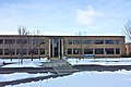
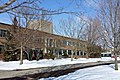
In 1950, the property became part of the Greber Plan that envisioned it as a government employment centre within a quiet and secure park-like campus. From the 1950s to the 1960s, 18 low-rise buildings were constructed with modern, classical-inspired architecture and similar materials, massing, and scale. Most of these combined research and office functionality under one roof. Starting in the 1970s however, new buildings and additions were built that deviated from Gréber's vision, introducing high-rise office towers, new architectural styles, and cladding materials to the site. [3] In 1971, Atomic Energy of Canada Limited built a SLOWPOKE-2 nuclear reactor on the site, which was moved to another site in 1984. [2]

Tunney's Pasture in 2008, before demolition of original buildings Tunney's Pasture.jpg
Tunney's Pasture in 2008, before demolition of original buildings

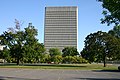
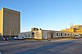
Little development took place in the 1990s, 2000s, and 2010s. By 2011, most buildings were considered outdated and the site under-used. Public Works and Government Services Canada has therefore initiated a plan to redevelop the campus with new high-rise buildings and mixed-use commercial and residential space over a 25-year period. In all, the plan aims to double the number of federal employees to 20,000 and add between 800 and 1000 residential units. [4] [5]

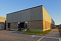
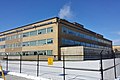
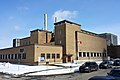
In 2020, modernization began with the construction of a wholly-new central heating and cooling plant that will be more energy efficient and complete with green roof. It will replace the existing one by 2025. [6]

List of original buildings

Various ministries and agencies occupy offices, in whole or in part, in Tunney's Pasture. [7] [5]

ImageNameBuilding #AddressYear builtYear demolishedPrimary tenantFloor area
(m²)
RH Coats Building 092022.jpg
R. H. Coats Building Building 1100 Tunney's Pasture Driveway
1974
n/a
Statistics Canada
40,829
Main Bldg Ottawa.JPG
Main Building Building 3150 Tunney's Pasture Driveway
1952
n/a
Statistics Canada
39,237
Jean Talon Bldg Ottawa.JPG
Jean Talon Building Building 5170 Tunney's Pasture Driveway
1979
n/a
Statistics Canada
60,906
Brooke claxton bldg ottawa.JPG
Brooke Claxton BuildingBuilding 970 Columbine Driveway
1964
n/a
Health Canada
20,972
Jeanne Mance Ottawa.JPG
Jeanne Mance BuildingBuilding 19200 Eglantine Driveway
1970
n/a
Health Canada
32,755
Laboratory Centre for Disease Control.jpg
Laboratory Centre for Disease ControlBuilding 6100 Eglantine Driveway
1954
n/a
Health Canada
11,247
Health Protection bldg Ottawa.jpg
Health Protection BuildingBuilding 7200 Tunney's Pasture Driveway
1956
2020-2021
Health Canada
10,317
Environmental Health Building.JPG
Environmental Health BuildingBuilding 850 Colombine Driveway
1965
2023
Health Canada
7,008
TP - Animal Breeding Bldg.jpg
Animal Breeding BuildingBuilding 12100 Chardon Driveway
1962
2018
Health Canada
3,073
Sir Frederick Banting Bldg .JPG
Sir Frederick G Banting Research CentreBuilding 22251 Sir Frederick Banting Driveway
1978
n/a
Health Canada
34,028
TP - Finance Bldg.jpg
Finance BuildingBuilding 2101 Tunney's Pasture Driveway
1952
2022
Health Canada
7,203
TP - OHU Bldg.jpg
Occupational Health Unit BuildingBuilding 1751 Chardon Driveway
1956
n/a
Health Canada
1,965
Blank.png
Virus LaboratoryBuilding 10Columbine Driveway
1954
2002-2005
Health Canada
TP - General Records Ctr.jpg
General Records CentreBuilding 15130 Goldenrod Driveway
1957
2018
Library and Archives Canada
17,044
TP - Personnel Records Ctr.jpg
Personnel Records CentreBuilding 18161 Goldenrod Driveway
1965
n/a
Library and Archives Canada
19,498
TP - Standards Bldg.jpg
Standards BuildingBuilding 4151 Tunney's Pasture Driveway
1954
n/a
Measurement Canada
4,463
TP - DND Data Ctr.jpg
National Defence Data CentreBuilding 16101 Goldenrod Driveway
1962
n/a
Department of National Defence
16,602
TP - Finance Annex Bldg.jpg
Finance AnnexBuilding 14100 Yarrow Driveway
1958
2022
Geological Survey of Canada
6,481
TP - Central Heating Plant.jpg
Central Heating and Cooling PlantBuilding 1350 Chardon Driveway
1952
n/a
1,719
TP - Butler Hut.jpg
Butler HutBuilding 11150 Chardon Driveway
1955
n/a
303
Blank.png
Atomic Energy of Canada BuildingBuilding 2020 Goldenrod Driveway
1955
1999-2002
Atomic Energy of Canada Limited
Blank.png
Eldorado Nuclear BuildingBuilding 21
unknown
1990s

Notes

  1. Statistics Canada, 71
  2. 1 2 "Tunney's Pasture redevelopment project". www.tpsgc-pwgsc.gc.ca. Government of Canada, Public Services and Procurement Canada. 27 July 2021. Retrieved 3 February 2023.
  3. "About Tunney's Pasture". Tunney's Pasture Master Plan. Public Works and Government Services Canada. 2012-08-17. Archived from the original on 2012-08-24. Retrieved 2012-08-20.
  4. Joanne Chianello (September 18, 2012). "Vision for Tunney's Pasture a clouded one". Ottawa Citizen. Retrieved 13 May 2014.
  5. 1 2 "Tunney's Pasture buildings past their prime". CBC News. November 24, 2011. Retrieved 13 May 2014.
  6. "Low carbon in the National Capital Region's buildings". www.tpsgc-pwgsc.gc.ca. Government of Canada, Public Services and Procurement Canada. 28 April 2017. Retrieved 3 February 2023.
  7. "Tunney's Pasture". Directory of Federal Real Property. Treasury Board of Canada Secretariat. Retrieved 8 April 2015.

Related Research Articles

<span class="mw-page-title-main">National Capital Commission</span> Crown corporation of the Government of Canada

The National Capital Commission is the Crown corporation responsible for development, urban planning, and conservation in Canada's Capital Region, including administering most lands and buildings owned by the Government of Canada in the region.

<span class="mw-page-title-main">Major-General George R Pearkes Building</span> Military office building in Ottawa, Canada

The Major-General George R. Pearkes Building is the principal location of Canada's National Defence Headquarters (NDHQ) and is located in downtown Ottawa, Ontario. NDHQ comprises a collection of offices spread across the National Capital Region, however it is primarily based at Major-General George R. Pearkes Building at 101 Colonel By Drive in Ottawa.

<span class="mw-page-title-main">Wellington Building</span>

The Wellington Building is a Beaux-Arts architecture office building in Ottawa, Ontario, Canada. It was built between 1924 and 1927 as Canadian headquarters of the Metropolitan Life Insurance Company. The original structure was designed by D. Everett Waid; in 1959, the more restrained classical east wing of the building was added.

<span class="mw-page-title-main">National Flag of Canada Day</span> Canadian holiday

National Flag of Canada Day, commonly shortened to Flag Day, is observed annually on February 15 to commemorate the inauguration of the flag of Canada on that date in 1965. The day is marked by flying the flag, occasional public ceremonies and educational programs in schools. It is not a public holiday, although there has been discussion about creating one.

<span class="mw-page-title-main">Carleton (Ontario federal electoral district)</span> Federal electoral district in Ontario, Canada

Carleton is a federal electoral district in Ontario, Canada, represented in the House of Commons of Canada from 1867 to 1968 and since 2015. It was represented in the Legislative Assembly of Upper Canada from 1821 to 1840 and in the Legislative Assembly of the Province of Canada from 1841 until 1866. It has been represented by Pierre Poilievre the current Leader of the Opposition since it's creation in 2015.

<span class="mw-page-title-main">Portrait Gallery of Canada</span>

The Portrait Gallery of Canada is a federally-registered not-for-profit corporation that currently has no collection or physical presence.

<span class="mw-page-title-main">R. H. Coats Building</span> Office building in Ontario, Canada

The R.H. Coats Building is a government office building located in the Tunney's Pasture government office complex in Ottawa, Ontario, Canada. It is situated near the intersection of Holland Avenue and Scott Street, beside Tunney's Pasture Station.

<span class="mw-page-title-main">Hintonburg</span> Neighbourhood in Ottawa, Ontario, Canada

Hintonburg is a neighbourhood in Kitchissippi Ward in Ottawa, Ontario, Canada, located west of the Downtown core. It is a historically working-class, predominantly residential neighbourhood, with a commercial strip located along Wellington Street West. It is home to the Parkdale Farmer's Market, located along Parkdale Avenue, just north of Wellington. It is considered to be one of Ottawa's most "hipster" neighbourhoods.

<span class="mw-page-title-main">Mechanicsville, Ottawa</span> Neighbourhood in Ottawa, Ontario, Canada

Mechanicsville is a neighbourhood in Kitchissippi Ward in central Ottawa, Ontario, Canada. It is located to the west of downtown and bordered by the Ottawa River to the north, the O-Train Trillium Line to the east, Scott Street to the south, and Parkdale Avenue to the west. East of Mechanicsville is LeBreton Flats, Tunney's Pasture is directly west, and Hintonburg is to the south. The total population of the neighbourhood as of the 2011 Census was 2,205.

<span class="mw-page-title-main">Kichi Zibi Mikan</span> Four-lane parkway in Ottawa, Canada

The Kichi Zībī Mīkan, formerly the Sir John A. Macdonald Parkway, and previously the Ottawa River Parkway, is a four-lane scenic parkway along the Ottawa River in Ottawa, Ontario, Canada. It runs from Carling Avenue near Connaught Avenue, to Booth Street at the Canadian War Museum and National Holocaust Monument. It is maintained by the National Capital Commission. The speed limit is 60 km/h (37 mph). Bicycles are allowed on the road and on a parallel recreational path along the parkway.

<span class="mw-page-title-main">Esquimalt Royal Navy Dockyard</span>

Esquimalt Royal Naval Dockyard was a major British Royal Navy yard on Canada's Pacific coast from 1842 to 1905, subsequently operated by the Canadian government as HMC Dockyard Esquimalt, now part of CFB Esquimalt, to the present day.

<span class="mw-page-title-main">Architecture of Ottawa</span>

The architecture of Ottawa is most marked by the city's role as the national capital of Canada. This gives the city a number of monumental structures designed to represent the federal government and the nation. It also means that as a city dominated by government bureaucrats, much of its architecture tends to be formalistic and functional. However, the city is also marked by Romantic and Picturesque styles of architecture such as the Parliament Building's Gothic Revival architecture.

The General Report on the Plan for the National Capital (1946–1950), or Gréber Plan, was a major urban plan developed for Canada's National Capital Region in 1950 by Jacques Gréber, commissioned by the Federal District Commission of Ottawa, Ontario.

<span class="mw-page-title-main">Civic Hospital</span> Neighbourhood in Ottawa, Ontario, Canada

Civic Hospital is a neighbourhood in Kitchissippi Ward in central Ottawa, Canada. It is named after the Ottawa Civic Hospital, which is located in the neighbourhood.

<span class="mw-page-title-main">Charlottetown</span> Capital city of Prince Edward Island, Canada

Charlottetown is the capital and largest city of the Canadian province of Prince Edward Island, and the county seat of Queens County. Named after Queen Charlotte, Charlottetown was an unincorporated town until it was incorporated as a city in 1855.

<span class="mw-page-title-main">Jean Talon Building</span> Federal office building in Ottawa, Ontario, Canada

The Jean Talon Building is a federal government office building in Ottawa, Ontario, Canada. It forms part of the complex of three buildings, including the R. H. Coats Building and the Main Building, that houses the headquarters of Statistics Canada. Jean Talon was also the first intendant of the New France project

<span class="mw-page-title-main">Main Building (Statistics Canada)</span> Building in Tunneys Pasture Driveway

The Main Building, or Main Statistics Canada Building, is a four-storey federal government office building located in the Tunney's Pasture area of Ottawa, Ontario, Canada. It is connected on the north side by the Jean Talon Building and on the south side by the R. H. Coats Building. Most of its 1,700 occupants work for Statistics Canada. Other tenants include Health Canada, Public Works and Government Services Canada, and SNC-Lavalin.

<span class="mw-page-title-main">Parkdale Avenue (Ottawa)</span> Street in Ottawa, Canada

Parkdale Avenue is an arterial road located west of downtown Ottawa, Ontario, Canada. It runs in a north-south direction between the Kichi Zibi Mikan and Carling Avenue in the Hintonburg and Civic Hospital neighbourhoods. It is an extremely busy road providing access to Tunney's Pasture, the Parkdale Market, the Ottawa Civic Hospital, and the Central Experimental Farm. Furthermore, it has direct connections to other major east-west arteries such as Scott Street, Wellington Street West, Gladstone Avenue, and Highway 417.

<span class="mw-page-title-main">Canada Place (Edmonton)</span> Office building in Edmonton, Alberta, Canada

Canada Place is a glass-and-steel office building in Edmonton, Alberta, Canada. Currently, it houses the main federal government offices for Edmonton and much of Western Canada. Located in downtown Edmonton, it was built by the Government of Canada and features a distinctive pink colour and stepped shape, a design intended to resemble the shape of the maple leaf on the Canadian flag. It neighbors the Edmonton Convention Centre and overlooks the North Saskatchewan River valley.

References

45°24′22″N75°44′13″W / 45.406194°N 75.736978°W / 45.406194; -75.736978