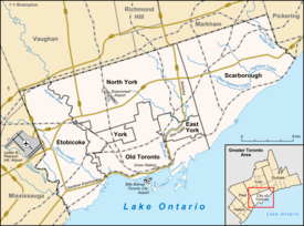
Etobicoke is an administrative district and former city within Toronto, Ontario, Canada. Comprising the city's west-end, Etobicoke is bordered on the south by Lake Ontario, on the east by the Humber River, on the west by Etobicoke Creek, the cities of Brampton, and Mississauga, the Toronto Pearson International Airport, and on the north by the city of Vaughan at Steeles Avenue West.

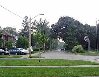
The Kingsway is a residential neighbourhood in Toronto, Ontario, Canada. It is bounded by Bloor Street to the south, Dundas Street to the north, the Mimico Creek to the west and the Humber River to the east. The neighbourhood was officially known as Kingsway Park, which later became replaced by its nickname, The Kingsway. For planning purposes, the neighbourhood is known by the City of Toronto as "Kingsway South" to differentiate it from a more recent extension of The Kingsway north of Dundas Street. "Kingsway South" is not used by residents, due to confusion with the South Kingsway, a street located east of the Humber River and extending south from Bloor Street.

New Toronto is a neighbourhood and former municipality in Toronto, Ontario, Canada. It is located in the south-west area of Toronto, along Lake Ontario. The Town of New Toronto was established in 1890, and was designed and planned as an industrial centre by a group of industrialists from Toronto who had visited Rochester, New York. New Toronto was originally a part of the Township of Etobicoke. It was an independent municipality from 1913 to 1967, being one of the former 'Lakeshore Municipalities' amalgamated into the Borough of Etobicoke, and eventually amalgamated into Toronto. The neighbourhood has retained the name.
Mimico is a neighbourhood in Toronto, Ontario, Canada, being located in the south-west area of Toronto on Lake Ontario. It is in the south-east corner of the former Township of Etobicoke, and was an independent municipality from 1911 to 1967.

Thistletown is a culturally diverse neighbourhood in Toronto, Ontario, Canada. It consists of the area surrounding the intersection of Albion Road and Islington Avenue. The borders of Thistletown are generally delineated by the Humber River: the West Branch to the south, slightly beyond the river to the east, and to the William Osler Health Centre - Etobicoke General Hospital just above the river in the north. The western border is Kipling Avenue, though the part of the neighbourhood west of Islington is sometimes considered a separate area named Beaumonde Heights.

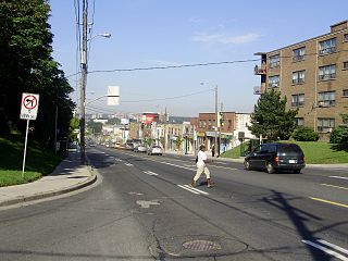
Kipling Avenue is a street in the cities of Toronto and Vaughan in Ontario, Canada. It is a concession road, 6 concessions (12 km) west from Yonge Street, and is a major north–south arterial road. It consists of three separate sections, with total combined length of 26.4 km. (16.4 mi.).

Richview, formally known as Willowridge-Martingrove-Richview, is a neighbourhood in the city of Toronto, Ontario, Canada. It is bounded on the west by Highway 401 and on the north by the highway and by Dixon Road, Royal York Road on the east, and Eglinton Avenue West along the south. Richview was originally established as a postal village within the then-agricultural Etobicoke Township, which later became the suburb of Etobicoke.

Eatonville is a neighbourhood in Toronto, Ontario, Canada. It is located west of the central core, in the former suburb of Etobicoke. Eatonville is bisected by Highway 427, with the community generally located north of Dundas Street West and south of Rathburn Road. Eatonville consists mainly of low density residential homes. The main arterial roads in the community, such as The West Mall, The East Mall and Burnhamthorpe Road, contain a mix of rental and condominium high-rise apartments and townhouses. Cloverdale Mall is in the neighbourhood, and there are community retail areas along Bloor Street West and Dundas Street West.
Markland Wood is a residential neighbourhood in Toronto, Ontario, Canada. It is located west of the central core, in the former suburb of Etobicoke and is the westernmost residential community in Toronto along Bloor Street West. It's located on the border of Mississauga and bounded by Etobicoke Creek to the west, Elmcrest Creek to the east, Burnhamthorpe to the North, and surrounded by the Markland Wood Golf Club; approximately 2/3 is north of Bloor Street, and 1/3 south. Markland Wood is part of the Etobicoke Centre riding for federal and provincial governments and Ward 2 for the municipal council.

Smithfield is a neighbourhood and former village in Toronto, Ontario, Canada. Some new residents of Toronto and new immigrants to Canada are attracted to this neighbourhood, mainly because there is a large amount of affordable public housing. It is named after the former village of Smithfield that was located at the intersection of Albion Road and Martin Grove Road. The neighbourhood is located north of the west branch of the Humber River and west of Kipling Avenue.

Humber Heights-Westmount, also known as Humbervale, is a neighbourhood in Toronto, Ontario, Canada. The neighbourhood is bounded by the west bank of the Humber River, west to Royal York Road and south to Eglinton Avenue West. The Humber Creek divides the area into the northern 'Humber Heights' and the southern 'Westmount' centred along Scarlett Road and La Rose Avenue.

Eringate-Centennial-West Deane is a neighbourhood in the city of Toronto, Canada. Eringate-Centennial-West Deane borders the city of Mississauga.

Islington-City Centre West is a commercial and residential neighbourhood in Toronto, Ontario, Canada. One of four central business districts outside Downtown Toronto, it is bounded by Rathburn Road to the north, Islington Avenue to the east, Bloor Street to the south, Mimico Creek to the west.
Vincent Massey Collegiate Institute is a Toronto District School Board facility that was previously operated as public secondary school in Toronto, Ontario, Canada. It was operated by the Etobicoke Board of Education in the former suburb of Etobicoke from its opening in 1961 until its closure in 1985 and later became the Vincent Massey Centre as an adult school until 1993. Owned and oversighted by the board's arms-length division, Toronto Lands Corporation, it is one of two schools in Etobicoke to be named for the late Governor General of Canada, the other was Vincent Massey Public School.
Silverthorn, often misspelled as Silverthorne, is a neighbourhood and former postal village in Toronto, Ontario, Canada. The approximate boundaries are the GO Transit Barrie line railway tracks to the east, Black Creek Drive and the CP railway line to the west and the former boundaries of the City of York to the north and south. The neighbourhood west of Keele Street is known as Keelesdale. For demographic purposes, the city breaks the area down into two neighbourhoods Keelesdale-Eglinton West, south of Eglinton, and Beechborough-Greenbrook north of Eglinton. It was originally a postal village to serve the then-agricultural York Township.
Lakeshore Collegiate Institute is a high school in Toronto, Ontario, Canada. Built in 1951, Lakeshore Collegiate is a merger of New Toronto Secondary School and Alderwood Collegiate Institute. It is situated on the northwest corner of Kipling Avenue and Birmingham Street in Ward 3 of the Toronto District School Board. It serves the New Toronto, Long Branch, Alderwood, and Mimico neighbourhoods.

Princess Gardens is a neighbourhood in Toronto, Ontario, Canada. It is located in the western area of Toronto that was formerly the City of Etobicoke. Its boundaries are Eglinton Avenue to the north, Martin Grove to the west, Islington to the east, and Rathburn Road to the south. The southeastern part of this area is the separate neighbourhood of Thorncrest Village. The neighbourhood is divided into two areas: The portion east of Kipling Road is known as Princess Anne Manor, while the portion west of Kipling is Princess Margaret Gardens. They are named after Princess Anne, Princess Royal, and Princess Margaret, Countess of Snowdon, the daughter and sister of the late Queen Elizabeth II respectively. Both Princesses visited the Gardens and opened up Princess Margaret Public School during its opening ceremony. The southwestern part of the neighbourhood is also sometimes known as Glen Agar. Princess Gardens has some of the highest income Canadians in the Greater Toronto Area according to a 2016 census, at an average of $222,218 per year.

Father John Redmond Catholic Secondary School and Regional Arts Centre is a Catholic high school in Toronto, Ontario, Canada. It is located in the New Toronto area of Etobicoke. It is operated by the Toronto Catholic District School Board as a regional art school for grades 9-12.

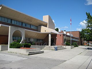
The Etobicoke Board of Education, officially known as the Board of Education for the City of Etobicoke is the former public-secular school board administering the schools of Etobicoke, Ontario, headquartered in the Etobicoke Civic Centre. In 1998, it was merged into the Toronto District School Board. The former EBE offices remain in use today by the TDSB as the West Education Office.