Gondwana is a region of India, named after the Gondi people who live there. The name of the ancient continent of Gondwanaland was derived from Gondwana, because some of the earliest rock formations of this continent were first investigated in part of the region, in modern Odisha.

Shaniwarwada is a historical fortification in the city of Pune in Maharashtra, India. Built in 1732, it was the great seat of the Peshwas of the Maratha Empire until 1818, when the Peshwas lost control to the British East India Company after the Third Anglo-Maratha War. Following the rise of the Maratha Empire, the palace became the center of Indian politics in the 18th century.

Mandla is a town with municipality in Mandla district in the Indian state of Madhya Pradesh. It is the administrative headquarters of Mandla District. The town is situated in a loop of the Narmada River, which surrounds it on three sides, and for 15 miles between Mandla and Ramnagar, Madhya Pradesh the river flows in a deep bed unbroken by rocks. The Narmada is worshiped here, and many ghats have been constructed on the banks of the river. It was a capital of the Gondwana Kingdom who built a palace and a fort, which in the absence of proper care have gone to ruins.
Aurangabad District is one of the 36 districts of the state of Maharashtra in western India. It borders the districts of Nashik to the west, Jalgaon to the north, Jalna to the east, and Ahmednagar to the south. The city of Aurangabad houses the district's administrative headquarters. The district has an area of 10,100 km2, of which 37.55% is urban and the rest is rural. Aurangabad District is a major tourism region in Marathwada.

Chandrapur is a city and a municipal corporation in Chandrapur district, Maharashtra state, India. It is the district headquarters of Chandrapur district. Chandrapur is a fort city founded by Khandkya Ballal Sah, a Gond king of the 13th century. The city sits at the confluence of the Irai river and Zarpat river. The area around the city is rich in coal seams.. Hence, Chandrapur is also known as the "black gold city".

Gadchiroli is a town and a municipal council in Gadchiroli district in the state of Maharashtra, central India. It is located on eastern side of Maharashtra, and is the administrative headquarters of the district. The main river flowing through city is the Wainganga. The landscape is lush and green during the monsoon season which is prone to flooding. Gadchiroli is known for its forests. Teak is grown commercially and bamboos are used for various crafts.
The Gwalior Fort is a hill fort near Gwalior, Madhya Pradesh, India. The fort has existed at least since the 10th century, and the inscriptions and monuments found within what is now the fort campus indicate that it may have existed as early as the beginning of the 6th century. Raja Suraj Sen Pal (Pal-Baghel) and his dynasty ruled over more than 900 year's. The fort has been controlled by a number of different rulers in its history.
Ballarpur is a city and a municipal council in Chandrapur district in the state of Maharashtra, India. It is the second largest city in the district.
Manikgad / is an ancient fort in Chandrapur district, Maharashtra. It is a hill fort 507 metres above sea level built by the Naga kings in 9 CE. The fort is in ruins and is frequented by wild animals that live in the vicinity, such as panthers and boars. Several monuments of historical importance are nearby.

Bhadravati is a city and a municipal council in Chandrapur district in the state of Maharashtra, India. It lies 26 km from Chandrapur city. It has an ordnance factory and several open-cast coal mines.

Sirpur (T) is a town and a mandal in Komaram Bheem district of the Indian state of Telangana.

The Shree Vajreshwari Yogini Devi Mandir is a Hindu temple dedicated to the goddess Vajreshwari, located in the town Vajreshwari, 75 km away from Mumbai. The town, earlier known as Vadvali, was renamed Vajreshwari in honour of the presiding deity of the temple.
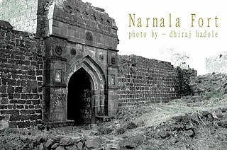
Narnala Fort or Narnala Killa Sarkar, also known as Shahnoor Fort, is a hill fortress in the Satpura Range of Vidarbh, Maharashtra, India, named after the Rajput Solanki Chaulukya Ruler, Raja Narnal Singh, also known as Narnal Singh Swami. It was renamed as "Shahnoor" by Islamic rulers but again acquired, rebuilt and got its name "Narnala" by ruler RaoRana Narnal Singh Solanki, who migrated from Rajasthan, Tonk district, originally by Patan, Gujarat and was a descendant of Narnal Singh Swami.

Akola fort along with the Narnala and Akot forts forms the major fortifications of the Akola district, Maharashtra, India.

Asifabad is a census town and the district headquarters of Kumuram Bheem district in the Indian state of Telangana. It is located in Komaram Bheem Asifabad mandal of Komaram Bheem Asifabad revenue division. It is named after Gond martyr Komaram Bheem. It is situated on the banks of Peddavagu river.It is about 309 kilometres (192 mi) north of the state capital Hyderabad,86 kilometres (53 mi) from Ramagundam and 148 kilometres (92 mi) from Karimnagar.
Hatgad Fort is a fort located 71 km (44 mi)from Nashik, Nashik district, of Maharashtra. The base village is Hatgad on the Nashik-Saputara Road. The nearest town is Saputara, which is 6 km from Hatgad village. It is a historic monument located in Maharashtra, India, south of the hill station of Saputara and near the border with Gujarat. It was built by the Maratha king Shivaji and is located at an elevation of about 3,600 feet. The only way to reach the fort is through a trekking route via a narrow rocky path. A statue of Lord Ganesha is placed on the top of the fort.

Vairagad is a small fort situated in the Gadchiroli district at the confluence of River Khobragadhi and Satnalas. The small dusty village by the name of the fort is adjacent to the fort. This fort is situated 180 km from Nagpur and 80 km from Chandrapur.

Erai river is a tributary of Wardha river and is an important river in Chandrapur district of Maharashtra. The river originates near Kasarbodi village of Chimur taluka and meets Wardha river near Hadasti village. It has a total length of 78 km and lies entirely within Chandrapur district.
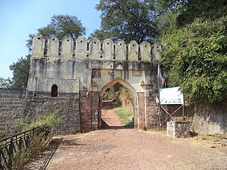
Ballarpur Fort is an ancient fort in Chandrapur district, Maharashtra. The fort is located in the Ballarpur city, on the east banks of river Wardha.
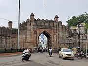 Jatpura gate of Chandrapur Fort
 Anchaleshwar gate of Chandrapur Fort
 Pathanpura gate of Chandrapur Fort


