Chiefs Head Peak

Last updated
Chiefs Head Peak
Chiefs Head Peak.jpg
North aspect
Highest point
Elevation 13,577 ft (4,138 m) [1]
Prominence 696 ft (212 m) [1] [2]
Parent peak Longs Peak (14,259 ft) [1] [3]
Isolation 1.45 mi (2.33 km) [1]
Coordinates 40°14′57″N105°38′28″W / 40.2490788°N 105.6411682°W / 40.2490788; -105.6411682 [4]
Geography
USA Colorado relief location map.svg
Red triangle with thick white border.svg
Chiefs Head Peak
Location in Colorado
Usa edcp relief location map.png
Red triangle with thick white border.svg
Chiefs Head Peak
Chiefs Head Peak (the United States)
CountryUnited States
State Colorado
County Boulder County
Protected area Rocky Mountain National Park
Parent range Rocky Mountains
Front Range
Topo map USGS Isolation Peak
Geology
Age of rock Precambrian [5]
Type of rock Granite of Longs Peak batholith [6]
Climbing
Easiest route class 2+ [1]

Chiefs Head Peak (Arapaho: Hookuhu'eeno) is a 13,577-foot-elevation (4,138-meter) mountain summit in Boulder County, Colorado, United States.

Contents

Description

Chiefs Head Peak is set along the Continental Divide in the Front Range of the Rocky Mountains. [3] The mountain is situated within Rocky Mountain National Park and is the third-highest peak in the park. [7] It is also the third-highest peak in Boulder County. [8] Precipitation runoff from the mountain's south slope drains into North St. Vrain Creek, the north slope drains to Glacier Creek which is a tributary of the Big Thompson River, and the lower west slope drains to Grand Lake via North Inlet. Topographic relief is significant as the summit rises 2,000 feet (610 meters) above Frozen Lake in one-half mile. The mountain's toponym was officially adopted in 1911 by the United States Board on Geographic Names. [4] The Arapaho called this peak hookuhu'eeno or "Head Mountain" because of a profile resemblance to a chief wearing a war bonnet. [9]

Climate

According to the Köppen climate classification system, Chiefs Head Peak is located in an alpine subarctic climate zone with cold, snowy winters, and cool to warm summers. [10] Due to its altitude, it receives precipitation all year, as snow in winter, and as thunderstorms in summer, with a dry period in late spring.

See also

Related Research Articles

<span class="mw-page-title-main">Powell Peak</span> Mountain in Colorado, United States of America

Powell Peak is a summit in Grand County, Colorado, in the United States. With an elevation of 13,176 feet (4,016 m), Powell Peak is the 493rd-highest summit in the state of Colorado.

<span class="mw-page-title-main">Tenmile Peak</span> Mountain in the American state of Colorado

Tenmile Peak is a 12,938-foot (3,944 m) mountain summit in Summit County, Colorado, United States.

<span class="mw-page-title-main">Mount Jasper</span> Mountain in the state of Colorado

Mount Jasper is a 12,923-foot (3,939 m) mountain summit on the boundary shared by Boulder County and Grand County, in Colorado, United States.

<span class="mw-page-title-main">Mount Cirrus</span> Mountain in the state of Colorado

Mount Cirrus is a 12,808-foot-elevation (3,904-meter) mountain summit in Colorado, United States.

<span class="mw-page-title-main">Mount Cumulus</span> Mountain in the state of Colorado

Mount Cumulus is a 12,729-foot-elevation (3,880-meter) mountain summit in Colorado, United States.

<span class="mw-page-title-main">Baker Mountain (Colorado)</span> Mountain in the American state of Colorado

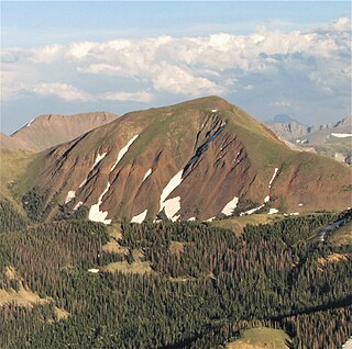
Baker Mountain is a 12,410-foot-elevation (3,780-meter) mountain summit in Grand County, Colorado, United States.

<span class="mw-page-title-main">Howard Mountain</span>

Howard Mountain is a 12,826-foot-elevation (3,909-meter) summit in Colorado, United States.

<span class="mw-page-title-main">Pagoda Mountain</span> Mountain in the United States

Pagoda Mountain is a 13,497-foot-elevation (4,114-meter) mountain summit in Boulder County, Colorado, United States.

<span class="mw-page-title-main">Stones Peak</span> Mountain in the state of Colorado

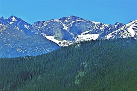
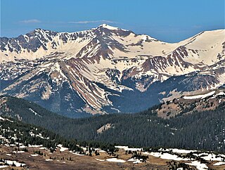
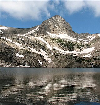
Stones Peak is a 12,922-foot-elevation (3,939-meter) mountain summit located in Larimer County, Colorado. It is situated in Rocky Mountain National Park, one mile east of the Continental Divide and 11.5 miles (18.5 km) west of the community of Estes Park. Stones Peak is part of the Front Range which is a subrange of the Rocky Mountains. Precipitation runoff from the mountain drains into tributaries of the Big Thompson River. Topographic relief is significant as the summit rises over 3,900 feet above the Big Thompson River in Forest Canyon in two miles. The peak is a prominent landmark viewed from Forest Canyon Overlook along the Trail Ridge Road.

<span class="mw-page-title-main">Sprague Mountain</span> Mountain in the state of Colorado

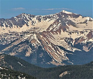
Sprague Mountain is a 12,713-foot-elevation (3,875-meter) mountain summit on the boundary shared by Grand County and Larimer County, in Colorado, United States. It is set on the Continental Divide in the Front Range of the Rocky Mountains, and 12.5 miles (20.1 km) west of the community of Estes Park. Precipitation runoff from the mountain's east side drains into tributaries of the Big Thompson River and the west slope drains into headwaters of Tonahutu Creek which flows to Grand Lake. Topographic relief is significant as the summit rises over 1,900 feet above Tonahutu Creek in one mile. The peak is visible from Trail Ridge Road.

<span class="mw-page-title-main">Apache Peak</span> Mountain in the state of Colorado

Apache Peak is a 13,441-foot (4,097 m) mountain summit on the boundary shared by Boulder County and Grand County, in Colorado, United States.

<span class="mw-page-title-main">Shoshoni Peak</span> Mountain in the state of Colorado

Shoshoni Peak is a 12,967-foot (3,952 m) mountain summit on the boundary shared by Boulder County and Grand County, in Colorado, United States.

<span class="mw-page-title-main">Navajo Peak</span> Mountain in the state of Colorado

Navajo Peak is a 13,409-foot (4,087 m) mountain summit on the boundary shared by Boulder County and Grand County, in Colorado, United States.

<span class="mw-page-title-main">Spread Eagle Peak</span> Mountain in the state of Colorado

Spread Eagle Peak is a 13,423-foot (4,091 m) mountain summit in Custer County, Colorado, United States.

<span class="mw-page-title-main">Mount Stratus</span> Mountain in the state of Colorado

Mount Stratus is a 12,534-foot-elevation (3,820-meter) mountain summit in Grand County, Colorado, United States.

<span class="mw-page-title-main">Paiute Peak</span> Mountain in the state of Colorado

Paiute Peak is a 13,088-foot (3,989 m) mountain summit on the boundary shared by Boulder County and Grand County, in Colorado, United States.

<span class="mw-page-title-main">Mount Toll</span> Mountain in the state of Colorado

Mount Toll is a 12,979-foot (3,956 m) mountain summit on the boundary shared by Boulder County and Grand County, in Colorado, United States.

<span class="mw-page-title-main">Pawnee Peak</span> Mountain in the state of Colorado

Pawnee Peak is a 12,943-foot (3,945 m) mountain summit on the boundary shared by Boulder County and Grand County, in Colorado, United States.

<span class="mw-page-title-main">Lulu Mountain</span>

Lulu Mountain is a 12,217-foot-elevation (3,724-meter) summit in Colorado, United States.

<span class="mw-page-title-main">Sawtooth Mountain (Boulder County, Colorado)</span>

Sawtooth Mountain is a 12,304-foot (3,750 m) summit on the boundary shared by Boulder County and Grand County, in Colorado, United States.

References

  1. 1 2 3 4 5 "Chiefs Head Peak - 13,577' CO". listsofjohn.com. Retrieved April 22, 2023.
  2. "Chiefs Head Peak, Colorado". Peakbagger.com. Retrieved April 22, 2023.
  3. 1 2 "Chiefs Head Peak, Peakvisor.com" . Retrieved April 22, 2023.
  4. 1 2 "Chiefs Head Peak". Geographic Names Information System . United States Geological Survey, United States Department of the Interior . Retrieved April 22, 2023.
  5. Lexicon of Geologic Names of the United States (including Alaska). Part 2 (1936), U.S. Government Printing Office, p. 2227.
  6. Geologic map of the Estes Park 30' x 60' quadrangle, north-central Colorado, W.A. Braddock, U.S. Geological Survey, 1984.
  7. Lisa Foster (2005), Rocky Mountain National Park: The Complete Hiking Guide, Westcliffe Publishers, ISBN   9781565795501, p. 59.
  8. Boulder County CO Peaks List, listsofjohn.com, Retrieved April 23, 2023.
  9. Joe Milligan (1997), Guide to the Colorado Mountains: I-70 Skylines, Westcliffe Publishers, ISBN   9781565791916, p. 22.
  10. Peel, M. C.; Finlayson, B. L.; McMahon, T. A. (2007). "Updated world map of the Köppen−Geiger climate classification". Hydrol. Earth Syst. Sci. 11. ISSN   1027-5606.