McHenrys Peak

Last updated
McHenrys Peak
McHenrys Peak.jpg
East aspect
Highest point
Elevation 13,327 ft (4,062 m) [1] [2]
Prominence 884 ft (269 m) [3]
Parent peak Chiefs Head Peak (13,577 ft) [3] [4]
Isolation 1.23 mi (1.98 km) [3]
Coordinates 40°15′47″N105°39′27″W / 40.2629199°N 105.6573871°W / 40.2629199; -105.6573871 [5]
Naming
Etymology Prof. Benjamin F. McHenry
Geography
USA Colorado relief location map.svg
Red triangle with thick white border.svg
McHenrys Peak
Location in Colorado
Usa edcp relief location map.png
Red triangle with thick white border.svg
McHenrys Peak
McHenrys Peak (the United States)
CountryUnited States
State Colorado
County Grand County / Larimer County
Protected area Rocky Mountain National Park
Parent range Rocky Mountains
Front Range
Topo map USGS McHenrys Peak
Geology
Age of rock Precambrian [6]
Type of rock Granite of Longs Peak batholith [7]
Climbing
Easiest route class 3 scrambling [3]

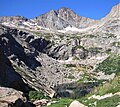
McHenrys Peak is a 13,327-foot-elevation (4,062-meter) mountain summit on the boundary shared by Grand County and Larimer County in Colorado, United States.

Contents

Description

McHenrys Peak is set on the Continental Divide in the Front Range of the Rocky Mountains. [4] The mountain is situated within Rocky Mountain National Park. It is the fifth-highest peak in Larimer County. [8] Precipitation runoff from the mountain's east slope drains into Glacier Creek which is a tributary of the Big Thompson River, and the west slope drains to Grand Lake via North Inlet. Topographic relief is significant as the summit rises 1,850 feet (560 meters) above Lake Powell in 0.62 mile (1 km) and 2,725 feet (831 meters) above Black Lake in one mile (1.6 km).

Etymology

The mountain's toponym was officially adopted in 1911 by the United States Board on Geographic Names. [5] Abner Sprague named the peak after Professor Benjamin F. McHenry of Union Christian College, Merom. [9] McHenry spent three summers in this area during the 1890s. Abner Sprague had a homestead at Sprague Lake with a view of McHenry Peak, Otis Peak, and Hallett Peak.

Climate

According to the Köppen climate classification system, McHenrys Peak is located in an alpine subarctic climate zone with cold, snowy winters, and cool to warm summers. [10] Due to its altitude, it receives precipitation all year, as snow in winter and as thunderstorms in summer, with a dry period in late spring.

See also

Related Research Articles

<span class="mw-page-title-main">Sharkstooth Peak</span> Mountain in the state of Colorado

Sharkstooth Peak is a 12,468-foot-elevation (3,800-meter) mountain summit in Montezuma County, Colorado.

<span class="mw-page-title-main">Powell Peak</span> Mountain in Colorado, United States of America

Powell Peak is a summit in Grand County, Colorado, in the United States. With an elevation of 13,176 feet (4,016 m), Powell Peak is the 493rd-highest summit in the state of Colorado.

<span class="mw-page-title-main">Electric Peak (San Juan Mountains)</span> Mountain in Colorado

Electric Peak is a 13,292-foot-elevation (4,051-meter) mountain summit located in San Juan County, Colorado, United States. It is situated eight miles south of the community of Silverton, in the Weminuche Wilderness, on land managed by San Juan National Forest. It is part of the Needle Mountains which are a subset of the San Juan Mountains, which in turn is a subset of the Rocky Mountains. Precipitation runoff from the mountain drains into tributaries of the Animas River. The peak can be seen from U.S. Route 550 and the Durango and Silverton Narrow Gauge Railroad. Topographic relief is significant as the west aspect rises over 4,500 feet above the river and railway in approximately two miles. It is set five miles west of the Continental Divide, and one mile east of Mount Garfield. The mountain's name, which has been officially adopted by the United States Board on Geographic Names, was in use before 1906 when Henry Gannett published it in the Gazetteer of Colorado.

<span class="mw-page-title-main">Potosi Peak</span> Mountain in Colorado, United States

Potosi Peak is a 13,786-foot-elevation (4,202-meter) mountain summit located in Ouray County of Colorado, United States. It is situated five miles southwest of the community of Ouray, on land managed by Uncompahgre National Forest. It is part of the Sneffels Range which is a subset of the San Juan Mountains, which in turn is part of the Rocky Mountains. It is situated west of the Continental Divide, 2.2 miles south of Whitehouse Mountain, and 2.5 miles southeast of Mount Sneffels. Potosi ranks as the 113th-highest peak in Colorado, and the fourth-highest in the Sneffels Range. Recreation enthusiasts heading for Yankee Boy Basin traverse below the southern base of the mountain. Topographic relief is significant as the southeast aspect rises 4,000 feet above the Camp Bird Mine in approximately 1.5 mile. The mining activity in the immediate area produced significant amounts of gold and silver. "Potosi" in Quechuan language translates to "great wealth.". The mountain's name, which has been officially adopted by the United States Board on Geographic Names, was in use before 1899 when Henry Gannett published it in A Dictionary of Altitudes in the United States.

<span class="mw-page-title-main">Mount Chapin</span> Summit in Rocky Mountain National Park

Mount Chapin is a 12,454-foot-elevation (3,796-meter) mountain summit located in Rocky Mountain National Park, in Larimer County, of Colorado, United States. It is situated 11 miles west-northwest of the community of Estes Park, one mile east of Chapin Pass, and six miles east of the Continental Divide. Mount Chapin is part of the Mummy Range which is a subset of the Rocky Mountains. Topographic relief is significant as the south aspect rises 2,700 feet above Fall River in less than one mile. Neighbors include Mount Chiquita and Ypsilon Mountain to the immediate northeast, and the park's Alpine Visitor Center is three miles to the west.

<span class="mw-page-title-main">Terra Tomah Mountain</span> Summit in Rocky Mountain National Park

Terra Tomah Mountain is a 12,718-foot-elevation (3,876-meter) mountain summit located in Rocky Mountain National Park, in Larimer County, of Colorado, United States. It is situated 13 miles west of the community of Estes Park, and 1.5 mile east of the Continental Divide. Terra Tomah Mountain is part of the Front Range which is a subset of the Rocky Mountains. Topographic relief is significant as the northeast aspect rises 3,300 feet above Forest Canyon in 1.5 mile. It is a prominent landmark viewed from Forest Canyon Overlook along the Trail Ridge Road.

<span class="mw-page-title-main">Hayden Spire</span> Summit in Rocky Mountain National Park

Hayden Spire is a 12,480+ foot elevation (3,800 meter) pillar located in Rocky Mountain National Park, in Larimer County, Colorado, United States. It is situated 12 miles west of the community of Estes Park in Hayden Gorge, along a short spur on the Continental Divide. Hayden Spire is part of the Front Range which is a subset of the Rocky Mountains. It is the highest tower in a cluster of spires which can be viewed from Forest Canyon Overlook along the Trail Ridge Road. Topographic relief is significant as the north aspect rises 2,100 feet above Hayden Gulch in one-half mile. Neighbors include Terra Tomah Mountain two miles to the north, and Mount Julian 1.8 mile to the northwest.

<span class="mw-page-title-main">Mount Nimbus</span> Mountain in the state of Colorado

Mount Nimbus is a 12,721-foot-elevation (3,877-meter) mountain summit in Grand County, Colorado, United States.

<span class="mw-page-title-main">Baker Mountain (Colorado)</span> Mountain in the American state of Colorado

Baker Mountain is a 12,410-foot-elevation (3,780-meter) mountain summit in Grand County, Colorado, United States.

<span class="mw-page-title-main">Chiefs Head Peak</span> Mountain summit in Boulder County, Colorado, United States

Chiefs Head Peak is a 13,577-foot-elevation (4,138-meter) mountain summit in Boulder County, Colorado, United States.

<span class="mw-page-title-main">Otis Peak</span> Mountain in the state of Colorado

Otis Peak is a 12,486-foot-elevation (3,806-meter) mountain summit on the boundary shared by Grand County and Larimer County, in Colorado, United States.

<span class="mw-page-title-main">Pagoda Mountain</span> Mountain in the United States

Pagoda Mountain is a 13,497-foot-elevation (4,114-meter) mountain summit in Boulder County, Colorado, United States.

<span class="mw-page-title-main">Stones Peak</span> Mountain in the state of Colorado

Stones Peak is a 12,922-foot-elevation (3,939-meter) mountain summit located in Larimer County, Colorado. It is situated in Rocky Mountain National Park, one mile east of the Continental Divide and 11.5 miles (18.5 km) west of the community of Estes Park. Stones Peak is part of the Front Range which is a subrange of the Rocky Mountains. Precipitation runoff from the mountain drains into tributaries of the Big Thompson River. Topographic relief is significant as the summit rises over 3,900 feet above the Big Thompson River in Forest Canyon in two miles. The peak is a prominent landmark viewed from Forest Canyon Overlook along the Trail Ridge Road.

<span class="mw-page-title-main">Sprague Mountain</span> Mountain in the state of Colorado

Sprague Mountain is a 12,713-foot-elevation (3,875-meter) mountain summit on the boundary shared by Grand County and Larimer County, in Colorado, United States. It is set on the Continental Divide in the Front Range of the Rocky Mountains, and 12.5 miles (20.1 km) west of the community of Estes Park. Precipitation runoff from the mountain's east side drains into tributaries of the Big Thompson River and the west slope drains into headwaters of Tonahutu Creek which flows to Grand Lake. Topographic relief is significant as the summit rises over 1,900 feet above Tonahutu Creek in one mile. The peak is visible from Trail Ridge Road.

<span class="mw-page-title-main">The Sharkstooth</span> Mountain in the state of Colorado

The Sharkstooth is a 12,630-foot-elevation (3,850-meter) mountain summit in Larimer County, Colorado, United States.

<span class="mw-page-title-main">Thatchtop</span> Mountain in the American state of Colorado

Thatchtop is a 12,668-foot-elevation (3,861-meter) mountain summit in Larimer County, Colorado, United States.

<span class="mw-page-title-main">Mount Craig (Colorado)</span> Mountain in the state of Colorado

Mount Craig is a 12,007-foot-elevation (3,660-meter) mountain summit in Grand County, Colorado, United States.

<span class="mw-page-title-main">Lulu Mountain</span>

Lulu Mountain is a 12,217-foot-elevation (3,724-meter) summit in Colorado, United States.

<span class="mw-page-title-main">Little Giant Peak</span> Mountain in the state of Colorado

Little Giant Peak is a 13,417-foot-elevation (4,090-meter) mountain summit in San Juan County, Colorado, United States.

<span class="mw-page-title-main">Kendall Peak (Colorado)</span> Mountain in the state of Colorado

Kendall Peak is a 13,455-foot-elevation (4,101-meter) mountain summit in San Juan County, Colorado, United States.

References

  1. Robert M. Ormes (2000), Guide to the Colorado Mountains, Colorado Mountain Club Press, ISBN   9780967146607, p. 43.
  2. "McHenrys Peak, Colorado". Peakbagger.com. Retrieved April 24, 2023.
  3. 1 2 3 4 "McHenrys Peak - 13,330' CO". listsofjohn.com. Retrieved April 24, 2023.
  4. 1 2 "McHenrys Peak, Peakvisor.com" . Retrieved April 24, 2023.
  5. 1 2 "McHenrys Peak". Geographic Names Information System . United States Geological Survey, United States Department of the Interior . Retrieved April 24, 2023.
  6. Lexicon of Geologic Names of the United States (including Alaska). Part 2 (1936), U.S. Government Printing Office, p. 2227.
  7. Geologic map of the Estes Park 30' x 60' quadrangle, north-central Colorado, W.A. Braddock, U.S. Geological Survey, 1984.
  8. Larimer County CO Peaks List, listsofjohn.com, Retrieved April 24, 2023.
  9. Louisa Ward Arps, Elinor Eppich Kingery, (1994), High Country Names: Rocky Mountain National Park and Indian Peaks, Johnson Books, ISBN   9781555661335
  10. Peel, M. C.; Finlayson, B. L.; McMahon, T. A. (2007). "Updated world map of the Köppen−Geiger climate classification". Hydrol. Earth Syst. Sci. 11. ISSN   1027-5606.