Hell's Glen | |
|---|---|
Glen | |
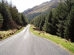 The road through Hell's Glen is the B839. | |
 Hell's Glen | |
| Coordinates: 56°13′01″N4°56′46″W / 56.217°N 4.946°W | |
| Grid position | NN1820306549 |
| Location | Cowal, Argyll and Bute, Scotland. |
| Formed by | glacial erosion |
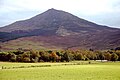
Hell's Glen is a glen in Argyll and Bute, Scotland, within the Arrochar Alps. The B839 single-track road passes through the glen. To the west, the glen leads to Loch Fyne and to the east Lochgoilhead. Glen Mhor (B828) joins the glen about half way along and leads to Glen Croe at the Rest & be Thankful viewpoint. [1] [2] [3]
Contents
The glen is named from its name in Gaelic, Glen Iarainn. This means "the Iron Glen" but sounds like the nearby Glen Ifhrinn which means "the Glen of Hell." [4] The glen is also known as An Gleann Beag, "the small glen", in Scottish Gaelic.
The glen is within the Argyll Forest Park that is itself within the Loch Lomond and The Trossachs National Park. [5] [6]