Howard Mountain

Last updated
Howard Mountain
Howard Mountain.jpg
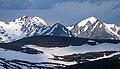
East aspect, from Trail Ridge Road
Highest point
Elevation 12,826 ft (3,909 m) [1]
Prominence 871 ft (265 m) [1]
Parent peak Mount Richthofen (12,945 ft) [1]
Isolation 2.93 mi (4.72 km) [1]
Coordinates 40°25′37″N105°53′56″W / 40.4270521°N 105.8988921°W / 40.4270521; -105.8988921 [2]
Geography
USA Colorado relief location map.svg
Red triangle with thick white border.svg
Howard Mountain
Location in Colorado
Usa edcp relief location map.png
Red triangle with thick white border.svg
Howard Mountain
Howard Mountain (the United States)
CountryUnited States
State Colorado
County Grand County / Jackson County
Protected area Rocky Mountain National Park
Never Summer Wilderness
Parent range Rocky Mountains
Never Summer Mountains
Topo map USGS Mount Richthofen
Geology
Type of rock Shale and granodiorite [3]
Climbing
Easiest route Northwest ridge class 2 [4]

Howard Mountain is a 12,826-foot-elevation (3,909-meter) summit in Colorado, United States.

Contents

Description

Howard Mountain is situated on the Continental Divide along the boundary shared by Grand County and Jackson County. [5] It is the second-highest peak of the Never Summer Mountains which are a subrange of the Rocky Mountains. [4] [6] The mountain is situated on the western boundary of Rocky Mountain National Park and is visible from Trail Ridge Road within the park. The west side of the peak is in the Never Summer Wilderness which is managed by Medicine Bow–Routt National Forest, and the peak is the highest point of the wilderness. [6] Precipitation runoff from the mountain's west slope drains into the South Fork of the Michigan River and the east slope drains into headwaters of the Colorado River except a portion of which is diverted by the Grand Ditch. The counterintuitive direction of water flow is because the Continental Divide forms a loop in this area, whereby the peak's west slope runoff flows to the Atlantic Ocean and the east slope to the Pacific. Topographic relief is significant as the summit rises over 3,600 feet (1,100 meters) above the Colorado River in three miles (4.8 km) and 2,600 feet (790 meters) above the South Fork Michigan River in one mile (1.6 km).

Howard Mountain centered in the distance Howard Mountain, snowy.jpg
Howard Mountain centered in the distance

Climate

According to the Köppen climate classification system, Howard Mountain is located in an alpine subarctic climate zone with cold, snowy winters, and cool to warm summers. [7] Due to its altitude, it receives precipitation all year, as snow in winter, and as thunderstorms in summer, with a dry period in late spring.

Climate data for Howard Mountain 40.4258 N, 105.8998 W, Elevation: 12,280 ft (3,743 m) (1991–2020 normals)
MonthJanFebMarAprMayJunJulAugSepOctNovDecYear
Average high °F (°C)20.1
(−6.6)
20.0
(−6.7)
27.0
(−2.8)
34.2
(1.2)
43.3
(6.3)
54.0
(12.2)
60.6
(15.9)
58.6
(14.8)
51.6
(10.9)
39.5
(4.2)
27.1
(−2.7)
20.3
(−6.5)
38.0
(3.4)
Daily mean °F (°C)11.7
(−11.3)
11.4
(−11.4)
17.4
(−8.1)
23.4
(−4.8)
32.5
(0.3)
42.8
(6.0)
49.8
(9.9)
47.8
(8.8)
41.0
(5.0)
29.9
(−1.2)
19.0
(−7.2)
11.9
(−11.2)
28.2
(−2.1)
Average low °F (°C)3.3
(−15.9)
2.9
(−16.2)
7.8
(−13.4)
12.7
(−10.7)
21.7
(−5.7)
31.7
(−0.2)
38.9
(3.8)
37.1
(2.8)
30.4
(−0.9)
20.3
(−6.5)
10.8
(−11.8)
3.6
(−15.8)
18.4
(−7.5)
Average precipitation inches (mm)3.79
(96)
3.91
(99)
4.14
(105)
5.19
(132)
4.53
(115)
2.22
(56)
2.24
(57)
2.56
(65)
2.62
(67)
3.49
(89)
3.71
(94)
3.38
(86)
41.78
(1,061)
Source: PRISM Climate Group [8]

Etymology

The namesake of the mountain's toponym is a mystery as it was applied on early maps, [9] perhaps it was named for an early prospector in this area. [10] The toponym was officially adopted in 1932 by the United States Board on Geographic Names. [2]

See also

Related Research Articles

<span class="mw-page-title-main">Truchas Peak</span>

Truchas Peak is the second highest peak in the U.S. State of New Mexico behind Wheeler Peak. It is in the Sangre de Cristo Mountains 26 miles (42 km) northeast of Santa Fe. It lies within the Pecos Wilderness, part of the Santa Fe National Forest. The name of the peak is Spanish for "trout" (plural). It is the highest point in both Rio Arriba and Mora counties. It is also the most southerly peak and land area in the continental United States to rise above 13,000 feet (3,962 m).

<span class="mw-page-title-main">James Peak</span>

James Peak is a high mountain summit in the Front Range of the Rocky Mountains of North America. The 13,294 foot thirteener is located on the Continental Divide in the James Peak Wilderness of Arapaho National Forest and Roosevelt National Forest, 5.2 miles (8.4 km) east-southeast of the Town of Winter Park, Colorado, United States. The summit is the tripoint of Clear Creek, Gilpin, and Grand counties. The peak is the highest point in Gilpin County and the second highest in James Peak Wilderness.

<span class="mw-page-title-main">Mount Zirkel</span> Mountain in the state of Colorado

Mount Zirkel is the highest summit of the Park Range of the Rocky Mountains of North America. The prominent 12,185-foot (3,714 m) peak is located in the Mount Zirkel Wilderness of Routt National Forest, 25.9 miles (41.7 km) north-northeast of the City of Steamboat Springs, Colorado, United States, on the Continental Divide between Jackson and Routt counties. Mount Zirkel was named in honor of German geologist Ferdinand Zirkel.

<span class="mw-page-title-main">Fairchild Mountain</span> Mountain in Colorado, United States

Fairchild Mountain is a high mountain summit in the Mummy Range of the Rocky Mountains of North America. The 13,508-foot (4,117 m) thirteener is located in the Rocky Mountain National Park Wilderness, 9.6 miles (15.5 km) northwest of the Town of Estes Park in Larimer County, Colorado, United States.

<span class="mw-page-title-main">Lead Mountain (Grand County, Colorado)</span> Mountain in Colorado, United States

Lead Mountain is a summit in Grand County, Colorado, in the United States. With an elevation of 12,546 feet (3,824 m), Lead Mountain is the 970th-highest summit in the state of Colorado. Lead Mountain was named in 1879 on account of its lead deposits.

<span class="mw-page-title-main">Powell Peak</span> Mountain in Colorado, United States of America

Powell Peak is a summit in Grand County, Colorado, in the United States. With an elevation of 13,176 feet (4,016 m), Powell Peak is the 493rd-highest summit in the state of Colorado.

<span class="mw-page-title-main">Mount Beulah</span> Mountain in the American state of Utah

Mount Beulah is a 12,557-foot elevation (3,827 m) mountain summit located in Summit County, Utah, United States.

<span class="mw-page-title-main">Haystack Peak</span>

Haystack Peak is a 12,020-foot elevation (3,664 m) mountain summit located in Juab County, Utah, United States.

<span class="mw-page-title-main">Square Top Mountain</span> Mountain in the state of Colorado

Square Top Mountain is a 13,794-foot (4,204 m) mountain summit in Clear Creek County, Colorado, United States.

<span class="mw-page-title-main">Mount Cirrus</span> Mountain in the state of Colorado

Mount Cirrus is a 12,808-foot-elevation (3,904-meter) mountain summit in Colorado, United States.

<span class="mw-page-title-main">Mount Cumulus</span> Mountain in the state of Colorado

Mount Cumulus is a 12,729-foot-elevation (3,880-meter) mountain summit in Colorado, United States.

<span class="mw-page-title-main">Mount Nimbus</span> Mountain in the state of Colorado

Mount Nimbus is a 12,721-foot-elevation (3,877-meter) mountain summit in Grand County, Colorado, United States.

<span class="mw-page-title-main">Baker Mountain (Colorado)</span> Mountain in the American state of Colorado

Baker Mountain is a 12,410-foot-elevation (3,780-meter) mountain summit in Grand County, Colorado, United States.

<span class="mw-page-title-main">Otis Peak</span> Mountain in the state of Colorado

Otis Peak is a 12,486-foot-elevation (3,806-meter) mountain summit on the boundary shared by Grand County and Larimer County, in Colorado, United States.

<span class="mw-page-title-main">McHenrys Peak</span> Mountain in the state of Colorado

McHenrys Peak is a 13,327-foot-elevation (4,062-meter) mountain summit on the boundary shared by Grand County and Larimer County in Colorado, United States.

<span class="mw-page-title-main">Mount Mahler</span> Mountain in the American state of Colorado

Mount Mahler is a 12,497-foot-elevation (3,809-meter) mountain summit in Jackson County, Colorado, United States.

<span class="mw-page-title-main">Mount Stratus</span> Mountain in the state of Colorado

Mount Stratus is a 12,534-foot-elevation (3,820-meter) mountain summit in Grand County, Colorado, United States.

<span class="mw-page-title-main">Cross Mountain (Colorado)</span> Mountain in the state of Colorado

Cross Mountain is a 12,703-foot-elevation (3,872-meter) summit on the border shared by Dolores and San Miguel County, in Colorado, United States.

<span class="mw-page-title-main">Lulu Mountain</span>

Lulu Mountain is a 12,217-foot-elevation (3,724-meter) summit in Colorado, United States.

<span class="mw-page-title-main">Darwin Peak</span>

Darwin Peak is an 11,647-foot-elevation (3,550-meter) mountain summit in Teton County, Wyoming, United States.

References

  1. 1 2 3 4 "Howard Mountain - 12,826' CO". listsofjohn.com. Retrieved 2023-04-22.
  2. 1 2 "Howard Mountain". Geographic Names Information System . United States Geological Survey, United States Department of the Interior . Retrieved 2023-04-22.
  3. Geologic map of the Mount Richthofen quadrangle and the western part of the Fall River Pass quadrangle, Grand and Jackson Counties, Colorado, J.M. O'Neill, U.S. Geological Survey, 1981.
  4. 1 2 Lisa Foster (2005), Rocky Mountain National Park: The Complete Hiking Guide, Westcliffe Publishers, ISBN   9781565795501, p. 338.
  5. "Howard Mountain, Colorado". Peakbagger.com. Retrieved April 22, 2023.
  6. 1 2 "Howard Mountain, Peakvisor.com" . Retrieved April 22, 2023.
  7. Peel, M. C.; Finlayson, B. L.; McMahon, T. A. (2007). "Updated world map of the Köppen−Geiger climate classification". Hydrol. Earth Syst. Sci. 11. ISSN   1027-5606.
  8. "PRISM Climate Group, Oregon State University". PRISM Climate Group, Oregon State University. Retrieved October 10, 2023. To find the table data on the PRISM website, start by clicking Coordinates (under Location); copy Latitude and Longitude figures from top of table; click Zoom to location; click Precipitation, Minimum temp, Mean temp, Maximum temp; click 30-year normals, 1991-2020; click 800m; click Retrieve Time Series button.
  9. James Dziezynski (2012), Best Summit Hikes in Colorado, Wilderness Press, ISBN   9780899977133, p. 82
  10. William Bright (2004), Colorado Place Names, Johnson Books, ISBN   9781555663339, p. 88.