
Sonoma County is a county located in the U.S. state of California. As of the 2020 United States Census, its population was 488,863. Its seat of government and largest city is Santa Rosa.

Sebastopol is a city in Sonoma County, California, with a recorded population of 7,521, per the 2020 U.S. Census.
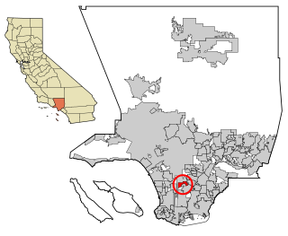
Willowbrook, alternatively named Willow Brook, is an unincorporated community and census-designated place (CDP) in Los Angeles County, California. The population was 24,295 at the 2020 census, down from 35,983 at the 2010 census.

Cambria is a seaside village in San Luis Obispo County, California, United States midway between San Francisco and Los Angeles along California State Route 1. The name Cambria, chosen in 1869, is the Latin name for Wales. Cambria is situated amidst Monterey pines in one of only three such native forests. The town previously had gone by the names of Slabtown, Rosaville, San Simeon, and Santa Rosa.

Fetters Hot Springs-Agua Caliente is a census-designated place (CDP) in Sonoma Valley, Sonoma County, California, in the United States. As of the 2010 census, the CDP population was 4,144. The name Agua Caliente translates into English, from Spanish, as hot water, referring to the hot springs historically found in the area.
Forestville is a census-designated place (CDP) in Sonoma County, California, United States. It was settled during the late 1860s and was originally spelled Forrestville after one of its founders. The spelling long ago became standardized with one "r". The population was 3,293 at the 2010 census, an increase of nearly 1,000 since the 2000 census.

Glen Ellen is a census-designated place (CDP) in Sonoma Valley, Sonoma County, California, United States. The population was 784 at the 2010 census, down from 992 at the 2000 census. Glen Ellen is the location of Jack London State Historic Park, Sonoma Valley Regional Park, and a former home of Hunter S. Thompson.

Graton is an unincorporated town and census-designated place (CDP) in west Sonoma County, California, United States. The population was 1,707 at the 2010 census. Graton's ZIP code is 95444. The town also has a culinary reputation attributed to two restaurants in the area.

Guerneville is an unincorporated community and census-designated place in the Russian River Valley of Sonoma County, California, United States. The town is historically known as a logging community. It was founded by the Guerne family in the 1850s.

Roseland is a neighborhood in Santa Rosa, California. As of the 2010 census, the population was 6,325. Roseland was an unincorporated enclave within the City of Santa Rosa until the area was annexed by Santa Rosa on November 1, 2017.

Santa Rosa is a city in and the county seat of Sonoma County, in the North Bay region of the Bay Area in California. Its population as of the 2020 census was 178,127. It is the largest city in California's Wine Country and Redwood Coast. It is the fifth most populous city in the Bay Area after San Jose, San Francisco, Oakland, and Fremont; and the 25th-most populous city in California.
Sonoma is a city in Sonoma County, California, United States, located in the North Bay region of the San Francisco Bay Area. Sonoma is one of the principal cities of California's Wine Country and the center of the Sonoma Valley AVA. Sonoma's population was 10,739 as of the 2020 census, while the Sonoma urban area had a population of 32,679. Sonoma is a popular tourist destination, owing to its Californian wineries, noted events like the Sonoma International Film Festival, and its historic center.

Larkfield-Wikiup is a census-designated place unincorporated area in Sonoma County, California, United States. The population was 8,884 at the 2010 census, up from 7,479 at the 2000 census. It comprises the Mark West area between Santa Rosa, Windsor (north), Calistoga (east), and Fulton (west). There are at least four schools within the limits of the CDP, including Cardinal Newman High School, John B. Riebli Elementary School, Mark West Elementary, and San Miguel Elementary schools.

Sonoma Valley is a valley located in southeastern Sonoma County, California, in the North Bay region of the San Francisco Bay Area. Known as the birthplace of the California wine industry, the valley is home to some of the earliest vineyards and wineries in the state, some of which survived the phylloxera epidemic of the 1870s and the impact of prohibition in the early 20th century. Today, the valley's wines are promoted by the U.S. federal government's Sonoma Valley and Carneros AVAs.

Bodega is an unincorporated community and census-designated place (CDP) in Sonoma County in the U.S. state of California. The town had a population of 220 as of the 2010 Census.
Valley Ford is an unincorporated community and census-designated place (CDP) in western Sonoma County, California, United States. It is located on State Route 1 north of San Francisco. Like all of Sonoma County, Valley Ford is included in both the San Francisco Bay Area and the Redwood Empire.
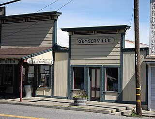
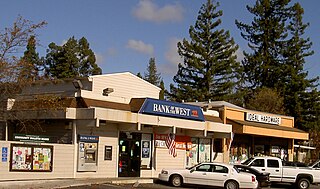
Geyserville is an unincorporated community and census-designated place (CDP) in Sonoma County, California, United States. Located in the Wine Country, Geyserville has a small selection of restaurants, bed and breakfasts, and wineries. Geyserville is located on California State Route 128, close to US Route 101. The population was 862 at the 2010 census.

Bloomfield is a census-designated place in Sonoma County, California, U.S. It is located in a rural area about 11 miles (18 km) southwest of Santa Rosa at the junction of Bloomfield Road and Valley Ford Road. Americano Creek flows westward along the south edge of the town.

Santa Rosa Valley is a rural unincorporated community, named after the eponymous valley in which it lies, located in Ventura County, California, United States. For statistical purposes, the United States Census Bureau has defined Santa Rosa Valley as a census-designated place (CDP). The census definition of the area may not precisely correspond to local understanding of the area with the same name. The 2010 United States census reported Santa Rosa Valley's population was 3,334. Santa Rosa Valley sits at an elevation of 433 feet (132 m).

Kenwood Depot was a railway station in Kenwood, California. It opened in 1887 as South Los Guilicos, and shares some features with the San Carlos station on the San Francisco Peninsula which was built around the same time. The station building was the only stone depot constructed for the Santa Rosa and Carquinez Railroad and cost $11,500 — tracks were on the east side. The station's name was changed to Kenwood in 1895 with the rest of the town. Rail service continued until 1936, and the rail line was removed in 1942. In 1940, Southern Pacific sold the depot to the Kenwood Improvement Club for $500 and it was converted into a community center. It was designated a Sonoma County Historic Landmark in 1980.


