List of Ancestral Puebloan dwellings in Colorado

Last updated

This is a list of Ancestral Puebloan dwellings in the U.S. State of Colorado .

Contents

The location of the State of Colorado in the United States of America. Colorado in United States.svg
The location of the State of Colorado in the United States of America .

Pueblo periods

Archaeologists have agreed on three main periods of occupation by Pueblo peoples in southwestern Colorado: Pueblo I, Pueblo II, and Pueblo III. [1]

Types of Buildings

In addition to the movable structures used by other Native Americans across North and South America, the Pueblo peoples created distinctive structures for living, worshiping, defense, storage, and daily life.

Locations

Archuleta County

Site namePueblo peoplesPeriodNearest town (modern name)LocationTypeDescriptionPhoto
Chimney Rock
(Site ID 5AA.985)
AnasaziPueblo II Chimney Rock Chimney Rock National Monument Great houseThe Ancient Pueblo People site, designated on the National Register of Historic Places in 1970, was a community inhabited between Durango and Pagosa Springs about 1,000 years ago with about 200 rooms. Rooms in the buildings were used for living, work areas and ceremonial purposes. The site is located within the San Juan National Forest Archaeological Area on 4,100 acres of land. Between May 15 and September 30 the Visitor Center is open and guided walking tours are conducted daily. [9] Great Kiva at Chimney Rock Colorado.JPG

Dolores County

For Canyons of the Ancients sites, also see the Canyons of the Ancients section.

Site namePueblo peoplesPeriodNearest town (modern name)LocationTypeDescriptionPhoto
Ansel Hall
(Site ID 5DL.27)
AnasaziPueblo II, Pueblo III Cahone Private ownerThe pueblo village was at least a moderate-sized community. [10] There was one occupation at Ansel Hall from 1080–1150, with its peak period about 1125. The community had great kivas and great houses. [11] Crow Canyon Archaeological Center Research found that at least one of the small sites was built late in the 11th century, about 1074. The village may have been abandoned by 1100, based upon the absence of 12th century white and black pottery. [12]
Brewer Archaeological District
(Site ID 5DL.578)
AnasaziPueblo II, Pueblo III Dove Creek Brewer Archaeological District has two large prehistoric settlement sites: Brewer Mesa Pueblo (11th century) and Brewer Canyon Pueblo (13th century). [13] Brewer Canyon Pueblo, part of the Upper Squaw Canyon Center, had 245 site clusters from 1225 to 1290. [14]
Champagne Springs (Greenlee) Ruins (Sites 5DL2333-5DL2338)AnasaziPueblo I, Pueblo IISquaw Point, s. of Dove Creek Ruins situated on two low hill tops on the top of Squaw Point Mesa approximately 6 miles south-southwest of Dove Creek, Colorado. Both sites are characterized by a material culture that appears to be representative of the years spanning the late Pueblo I and early Pueblo II periods. [15]

La Plata County

Site namePueblo peoplesPeriodNearest town (modern name)LocationTypeDescriptionPhoto
Darkmold Site
(Site ID 5LP4991)
AnasaziBasketmaker Durango The Late Archaic Basketmaker II Darkmold Site, inhabited from about 220 BC through AD 750, was added to the Colorado Register of Historic Properties in 2000. Archaeological evidence found at the site include slab-lined roasting pits and bell-shaped pits. [16]
Durango Rock Shelters Archeology Site
(Site ID 5LP4134)
AnasaziBasketmaker, Pueblo I Durango Durango Rock Shelters Archeology Site, also known as the Fall Creek Rock Shelters Site, is an Ancient Pueblo People (Anasazi) archaeological site, located in La Plata County, Colorado. People from the Late Basketmaker II and Basketmaker III Eras inhabited the site between AD 1 and AD 1000. [17]
Spring Creek Archeological District
(Site ID 5LP1254)
AnasaziBasketmaker, Pueblo periods Bayfield Spring Creek Archaeological District, also known as Zabel Canyon Indian Ruins, is located in the San Juan National Forest. The site was inhabited from 300 BC through Pueblo times Ancient Pueblo People. In the protohistoric periods of southwestern Colorado the Ute, Apache and Navajo ranged and lived in the area. It was added to the National Register of Historic Places in 1983. [16]
Talus Village
(Site ID 5LP4223)
AnasaziBasketmaker Durango Talus Village, a Basketmaker II site with Basketmaker pit-house dwellings, was excavated in 1940 by Earl Morris, the first archaeologist to conduct professional excavations in LaPlata County. It was added to the Colorado Register of Historic Properties in 1996. [16]
Ute Mountain Ute Tribe
(Site ID 5MT.4342)
AnasaziPueblo I, Pueblo II, Pueblo III Red Mesa Ute Mountain Ute Mancos Canyon Historic District, located on the Ute Mountain Ute Tribe reservation, was added to the National Register of Historic Places in 1972. It was occupied by puebloan people during the broad periods from 500 to 1499 [they left southwestern Colorado by 1300]. [17]

Montezuma County

Anasazi Heritage Center

Site namePueblo peoplesPeriodNearest town (modern name)LocationTypeDescriptionPhoto
Escalante
(Site ID 5MT2149)
AnasaziPueblo II, Pueblo III Dolores Anasazi Heritage Center Great houseRuins. Escalante Pueblo was constructed approximately 1120 to 1130 and made of groupings of stone walled family and communal rooms, including kivas. The architecture is like that of the Chaco Canyon in present-day New Mexico. [18] The pueblo was also occupied about 1150 and again 1200. [19] Anasazi Heritage Center - CO - BLM - Escalante Pueblo.jpeg
Dominguez AnasaziPueblo II, Pueblo III Dolores Anasazi Heritage Center Great houseRuins. Dominguez Pueblo, an example of independent family homes outside the main pueblo. Discovered at the site were items that shed light on how the people may have lived, including "6,900 turquoise, jet and shell beads; a shell and turquoise frog pendant and mosaics, two fine ceramic vessels, six bone scrapers, a woven mat and many other items." [18] Anasazi Heritage Center - CO - BLM - Dominguez Pueblo.png

Canyons of the Ancients

Site namePueblo peoplesPeriodNearest town (modern name)LocationTypeDescriptionPhoto
Sand Canyon
(Site ID 5MT16853)
AnasaziPueblo III Dolores Canyons of the Ancients National Monument One of the largest pueblos of the 13th century, Sand Canyon Pueblo, built between 1250 and 1280, contains at least 20 multi-family room blocks with 420 rooms, 90 kivas, and 14 towers. A spring runs through the center of the walled site that held up to 725 people. Construction was exacting, with care taken to shape stone, and some double and triple walls for stability. Families lived in clusters of rooms that included living, storage and work rooms and had their own family kivas. The community shared roofed plazas, great kivas and towers often connected to kivas. By 1280 new construction had stopped and people began migrating out of the pueblo; By 1290 the pueblo was abandoned, as were other Colorado pueblo sites, never to be inhabited again by puebloan people. [20] [21] The Northern San Juan pueblo, significant for its ceremonial use and burial remains, was added to the National Register of Historic Places in 2005. [17]
Castle Rock PuebloAnasaziPueblo III Dolores Canyons of the Ancients National Monument Great houseThere was one occupation at the Castle Rock Pueblo from 1250–1275, with its peak period about 1260. The community had Great Houses. [11] There were at least 16 kivas, 40 surface rooms, nine possible towers, and a D-shaped enclosure.
Lowry Pueblo
(Site ID 5MT1566)
AnasaziPueblo II Pleasant View Canyons of the Ancients National Monument There was one occupation at Lowry Pueblo from 1080–1150, with its peak period about 1125. The community had Great Houses, Great kivas and roads. [11] The Lowry Pueblo National Historic Landmark consists of 8 kivas, a great (community) kiva and 40 rooms built as high as three stories. The underground great kiva was built about 1103 and had murals painted over about 5 layers of plaster. About 1110 another kiva was built on top of the original kiva. Based upon the size of the kiva it's thought that the Lowry Pueblo may have been a local center for religious gatherings and celebration. [20] [22] [23] Lowry Pueblo.jpg

Hawkins Preserve

Site namePueblo peoplesPeriodNearest town (modern name)LocationTypeDescriptionPhoto
Hawkins Pueblo AnasaziPueblo II Cortez Cortez Cultural Center, Hawkins Preserve Hawkins Pueblo, occupied by several related groups, is the largest ruin within the preserve. It was most populated in the Pueblo II period, from about 1000 to 1150. The site contains several room block ruins and rubble that contains a kiva, mounds, and middens. [24]

Hovenweep National Monument

The Hovenweep National Monument (Site ID 5MT.604) is registered on the National and Colorado State Historic Registers.

Site namePueblo peoplesPeriodNearest town (modern name)LocationTypeDescriptionPhoto
Cajon GroupAnasaziBetween Cortez, CO and Blanding, UT Hovenweep National Monument Cajon Group, constructed like the Holly, Hackberry and Horseshoe configuration, is located at the head of Allen Canyon. It consists of a cluster of room blocks and the remains of a tower, estimated to house 80-100 people, that was constructed on a boulder that sits below the rim of the canyon. [25] [26] Up to seven kiva depressions are located around the spring. Remnants of wall alignments below the rim on the talus represent possible terrace farming. [27]
Cutthroat Castle GroupAnasaziBetween Cortez, CO and Blanding, UT Hovenweep National Monument Cutthroat Castle, the largest of the remains, is located on the north side of the stream. Cutthroat is unique among the units due to the lack of a spring, the numerous kivas and the fact that much of the architecture sits below the rim. [28]
Goodman Point (Site ID 5MT604)AnasaziPueblo II, Pueblo IIIBetween Cortez, CO and Blanding, UT Hovenweep National Monument Goodman Point group, the largest and easternmost village, contains small and large clusters of pueblo buildings built partially underground. It was most heavily populated in between 1150-1300, the Pueblo III period. Earlier residents include Basketmakers from 200-450 and during the second Pueblo period 900-1150. [29] [31]
Hackberry and Horseshoe groupAnasaziPueblo IIIBetween Cortez, CO and Blanding, UT Hovenweep National Monument Hackberry was a medium-sized Pueblo III village in the east fork of Bridge Canyon. [32] About 250 to 350 inhabitants are thought to have resided in the Hackberry Group. Located about 500 yards away, the Horseshoe group consists of four pueblo buildings that for a U-shape. [33] Horseshoe Ruin had a dam at the rim to create a reservoir. Horseshoe House is a D-shaped structure containing three rooms surrounding a possible central kiva. The architectural style suggests ceremonial or public use. [32] About 800 years ago the buildings were constructed with "precisely fit" stones and set with mortar of sand, ash, clay and water. [33]
Holly GroupAnasaziBetween Cortez, CO and Blanding, UT Hovenweep National Monument The Holly group is located at the head of Keeley Canyon. [34] Holly is the site known for a rock art panel that has been interpreted as a summer solstice marker. [35] The five named buildings at the site are Curved Wall House, Great House, Holly Tower, Isolated Boulder House and Tilted Tower. [36]
Hovenweep CastleAnasaziBetween Cortez, CO and Blanding, UT Hovenweep National Monument Hovenweep.jpg
Hovenweep HouseAnasaziBetween Cortez, CO and Blanding, UT Hovenweep National Monument
Rim Rock HouseAnasaziBetween Cortez, CO and Blanding, UT Hovenweep National Monument
Stronghold HouseAnasaziBetween Cortez, CO and Blanding, UT Hovenweep National Monument
Square TowerAnasaziBetween Cortez, CO and Blanding, UT Hovenweep National Monument Square Tower group is the largest collection of pueblo buildings at Hovenweep and was populated with up to 500 people. It is located in Little Ruin Canyon [37] which is made up of Square Tower, Tower Point, and Twin Towers ruin groups. Towers at Hovenweep were built in a variety of shapes; D-shapes, squares, ovals and circles [38] and for several purposes, including tool and grinding work areas, kivas for ritual functions, residential rooms and storage. [39] Towers have limited access, contain few windows and many have narrow slots or peepholes placed in the walls. The slots and doors of Hovenweep Castle, in Square Tower Group, have been shown to define an apparent solar calendar. The building is aligned so that light is channeled through openings into the building at sunset of the summer solstice, the winter solstice and the spring and fall equinox. The light falls in a predictable pattern on interior door lintels. [39] [40] Squaretower.JPG
Twin TowersAnasaziBetween Cortez, CO and Blanding, UT Hovenweep National Monument

McElmo Drainage Unit

The McElmo Drainage Unit, located in Montezuma and Dolores Counties, consists of tributaries of McElmo Creek, situated north of the northern slopes of Mesa Verde and Ute Mountain, that is part of the northern San Juan River drainage. [41] For Sand Canyon, see the Canyons of the Ancients and for Ansel Hall, see Dolores County.

Site namePueblo peoplesPeriodNearest town (modern name)LocationTypeDescriptionPhoto
Albert Porter Pueblo
(Site ID 5MT123)
AnasaziPueblo II, Pueblo III Yellow Jacket Private ownerGreat houseAlbert Porter Pueblo, also known by its Site ID and as Hedrick Ruin, was a small puebloan North San Juan village. [17] See the Crow Canyon Archaeological Center.
Unnamed (Site ID 5MT4700) AnasaziPueblo III Yellow Jacket There was one occupation from 1200–1250 of the Mesa Verde culture site. [42]
Bass site
(Site ID 5MT136)
AnasaziPueblo II Yellow Jacket Federal ownerThere was one occupation with Great Houses at the Bass Site from 1080–1150, with its peak period about 1125. [11] Based upon reporting to the Colorado Historical Society, occupancy extended into the early 13th century. [42] The North San Juan pueblo site was added to the National Register of Historic Places for Montezuma County, Colorado in 1999. [17]
Cannonball Ruins
(Site ID 5MT338)
AnasaziLate Pueblo II, Pueblo III Cortez Private ownerCannonball Ruins, part of the Great Pueblo Period of the McElmo Drainage Unit, was occupied from 1140-1300. The large settlement had architectural characteristics similar to the nearby Hovenweep pueblos. The site was first excavated in 1908 by Sylvanus Morley. Cannonball Ruins has been listed on the Colorado State Register of Historical Properties and the National Register for Historic Places since 1997. [42]
James A. Lancaster Site
(Site ID 5MT4803)
AnasaziBasketmaker, Pueblo I-III Pleasant View Private ownerRuins also called Clawson Ruins [42] were of the Pueblo tradition from the broad periods of 1-1499 AD [Pueblo people left Montezuma County area by 1300.] The previous village was added to the National Register of Historic Places in 1980. [17]
Joe Ben Wheat Site Complex
(Site ID 5MT.16722)
AnasaziPueblo II, Pueblo III Yellow Jacket Ruins from about 1075-1300. The site is a large multi-component site with 90 rooms and 14 kivas. [42]
Mitchell Springs Archeological Site
(Site ID 5MT.10991)
AnasaziBasketmaker, Pueblo I, Pueblo II Cortez Private ownerRuins from 500 - 1000, [42] also known as the Mitchell Springs Ruin Group, is a Northern San Juan pueblo. It was added to the National Register of Historic Places in Montezuma County in 2001. [17] Ruins of 9 medium-sized pueblos from the Basketmaker II period to late Pueblo III. Occupying up to 1,000 people the pueblo had a total of 300 rooms, 35 kivas and towers.
Mud Springs Pueblo
(Site ID 5MT4466)
AnasaziPueblo III Cortez Private ownerRuins, also called Toltec Springs, [42] was occupied from 1200–1250, with its peak period about 1225. The community had reservoirs and construction with double or triple walls. [11] The pueblo site was added to the National Register of Historic Places in 1982, [17]
Pigge Site
(Site ID 5MT4802)
AnasaziBasketmaker, Pueblo I-III Pleasant View Private ownerThere was an occupation, with roads, at the Pigge Site from 1175–1225, with its peak period about 1200. [11] The National Register of Historic Places reports occupation through the broad periods of AD 1 - 1499 [by 1300 puebloan people from southwestern Colorado had migrated out of their pueblos.] The site was added to the National Register of Historic Places in 1980. [17]
Roy's Ruin
(Site ID 5MT3930)
AnasaziPueblo III Cortez Roy's Ruin, part of the Great Pueblo Period of the McElmo Drainage Unit, was occupied in the early 13th century. It is a classic Prudden Unit. The pueblo was built with masonry construction in roomblocks. The small site had a tower, kiva and a midden. Roy's Ruin has been listed on the Colorado State Register of Historical Properties and the National Register for Historic Places since 1992. [42]
Seven Towers Pueblo
(5MT1000)
AnasaziPueblo III Yellow Jacket Federal ownerThe Northern San Juan pueblo ruins from about 1150-1300 was added to the National Register of Historic Places in 1999. [17]
Wallace Ruin
(Site ID 5MT5670)
AnasaziPueblo II, Pueblo III Cortez PrivateWallace Ruin, was a Northern San Juan and Chaco pueblo inhabited during the broad 1000 to 1499 period [Ancient Pueblo People left southwestern Colorado by 1300]. It was added to the National Register of Historic Places in 2005. [17]
Woods Canyon Pueblo
(Site ID 5MT.11842)
AnasaziPueblo II, Pueblo III Yellow Jacket FederalGreat houseWoods Canyon Pueblo, also known as Wood Canyon Ruin, was a Northern San Juan pueblo inhabited during the broad 1000 to 1499 period [Ancient Pueblo People left southwestern Colorado by 1300]. It was added to the National Register of Historic Places in 1999. [17] Ruins consisting of as many as 200 rooms, 50 kivas, and 16 towers, and possibly a plaza.
Yellow Jacket Pueblo
(Site ID 5MT5)
AnasaziPueblo II, Pueblo III Yellow Jacket Private owner.Great houseYellowjacket pueblo experienced two periods of occupation. The first occurred between 1075 and 1150, with peak residency in 1125. The next period occurred between 1175 and 1250. The peak of the second period occurred in 1225. The community had Great Houses, Great kivas, reservoirs and roads. [11] Yellow Jacket pueblo was a village of the Mesa Verde culture was added to the National Register of Historic Places in 1985. [17] Covering 100 acres, the pueblo contains at least 195 kivas (including a probable great kiva), 19 towers, a possible Chaco-era great house, and as many as 1,200 surface rooms. See the Crow Canyon Archaeological Center.

Mesa Verde

Mesa Verde National Park (Site ID 5MT.9790) is listed in the National and State Registers of Historic places.

Site namePueblo peoplesPeriodNearest town (modern name)LocationTypeDescriptionPhoto
Balcony HouseAnasazi Cortez Mesa Verde National Park Great houseRuins. Set on a high ledge facing east, Balcony House with 45 rooms and 2 kivas, which would have been cold for its residents in the winter. The modern visitor enters by climbing a 32-foot ladder and a crawling through a 12-foot tunnel. The exit, a series of toe-holds in a cleft of the cliff, was believed to be the only entry and exit route for the cliff dwellers, which made the small village was easy to defend. One log was dated at 1278 so it was likely built not long before the Mesa Verde people migrated out of the area. [43] [44] Visitors can enter Balcony House through ranger guided tours. [45]

This photo is of an Emmett Harryson, a Navajo, at a T-shaped doorway at Balcony House (1929).
HPC 000119 (27512883666).jpg
Cliff Palace Anasazi Cortez Mesa Verde National Park This multi-storied ruin, the largest and best-known of the cliff dwellings in Mesa Verde, is located in the largest cave in the center of the Great Mesa. It was south and southwest facing, providing greater warmth from the sun in the winter. The site had 217 rooms, including storage rooms, open courts, walkways, and 23 kivas. Many of the rooms were brightly painted. [46] [47] Cliff Palace at Mesa Verde.jpg
Fire TempleAnasazi Cortez Mesa Verde National Park Mesa Verde National Park Fire Temple and New Fire House 2006 09 12.jpg
Long HouseAnasazi Cortez Mesa Verde National Park Cliff dwellingsRuins. Located on the Wetherill Mesa, Long House is the 2nd largest village for about 150 people. The 150 rooms are not clustered like the standard cliff dwellings, nor is it one of the most elegant set of buildings; Stones were used without shaping for fit and stability. Two overhead ledges contain more rooms. One ledge seems to include an overlook with small holes in the wall to see the rest of the village below. A spring is accessible within several hundred feet and seeps are located in the rear of the village. [48] Long House cliff dwellings at Mesa Verde, 2006May23.jpg
Mesa Verde ReservoirsAnasazi Cortez Mesa Verde National Park A Historic Civil Engineering Landmark. These ancient reservoirs, built by the Ancient Puebloans, were named a National Civil Engineering Historic Landmark on September 26, 2004. 249FarViewReservoir.JPG
Mug HouseAnasazi Cortez Mesa Verde National Park This ruin situated on Wetherill Mesa was professionally excavated in the late 1960s by archaeologist Arthur Rohn. The structure contains 94 rooms, in four levels, including a large kiva, with simple vertical walls and masonry pilasters. This ceremonial structure has a keyhole shape, due to a recess behind the fireplace and a deflector, that is considered an element of the Mesa Verde style. The rooms clustered around the kiva formed part of the courtyard, indicating the kiva would have been roofed.
Oak Tree HouseAnasazi Cortez Mesa Verde National Park Ruins. Oak Tree House and neighboring Fire Temple can be visited via a 2-hour ranger-guided hike. [49] 16 21 2340 mesa verde.jpg
Spruce Tree HouseAnasazi Cortez Mesa Verde National Park Ruins. Spruce Tree House is the 3rd largest village, within several hundred feet of a spring, had 130 rooms and 8 kivas. Because of its protective location, it is well preserved. [50] [51] The short trail to Spruce House begins at the Chapin Mesa Archeological Museum. [52] Mesa Verde National Park Spruce Tree House Three Storeyed House 2006 09 12.jpg
Square Tower HouseAnasaziPueblo III Cortez Mesa Verde National Park The Square Tower House is one of the stops on the Mesa Top Loop Road diving tour. [52] The tower that gives this site its name is the tallest structure in Mesa Verde. This cliff dwelling was occupied between 1200 and 1300. Square Tower.jpeg

Towaoc area

Site namePueblo peoplesPeriodNearest town (modern name)LocationTypeDescriptionPhoto
Cowboy Wash
(Site ID 5MT10010)
AnasaziPueblo III Towaoc The site is dated between approximately 1150 and 1175 A.D. It is located on the south slopes of Ute Mountain. Some archeologists believe that the site was settled by immigrants from Chaco Canyon, or the Chuska Mountains. [53]
Ute Mountain Ute Tribe
(Site ID 5MT.4342)
AnasaziPueblo I, Pueblo II, Pueblo III Towaoc Ute Mountain Ute Mancos Canyon Historic District, located on the Ute Mountain Ute Tribe reservation, was added to the National Register of Historic Places in 1972. [17] Eagle's Nest pueblo.jpg
Yucca House
(Site ID 5MT5006)
AnasaziPueblo II, Pueblo III Towaoc Yucca House National Monument Pueblo villageThere were two occupations at Yucca House: 1) 1080-1150, with its peak period about 1125 and 2) 1225-1275, with its peak in 1250. The community had Great kivas and Great Houses. [11] Two unexcavated settlement areas covered in vegetation include: 1) Western Complex was a large pueblo of up to 600 rooms, 100 kivas and a giant, perhaps community, kiva. A spring runs through the complex. A large building, Upper House, was made of adobe. 2) Lower House is an L-shaped pueblo with a plaza, 8 rooms and a large kiva. [30] Yucca-House-NM.jpg

Other

The sites are sorted by nearest town and site name.

Site namePueblo peoplesPeriodNearest town (modern name)LocationTypeDescriptionPhoto
O'Brien Site
(Site ID 5MT.5518)
AnasaziPueblo II Dolores Ruins from 1075 - 1150. On the Colorado State Register of Historic Properties. [42]
Bement Site
(Site ID 5MT.4388)
AnasaziPueblo I, Pueblo II Mancos Bement Site is a Colorado State Register of Historic Properties site, representing the first and second Pueblo periods. Between 750-850 there was one shelter on the site. About 150 years later, a group of six structures were inhabited from 1000 to 1150. [42]
Lost Canyon Archeological District
(Site ID 5MT.10435)
AnasaziPueblo II, Pueblo III Mancos Federal ownerRuins from 1050-1300 [42] or earlier was Mesa Verde culture pueblo. It was added to the National Register of Historic Places in 1988. [17]
Puzzle House
(Site ID 5MT.11787)
AnasaziBasketmaker, Pueblo II-III Pleasant View Puzzle House, is a pueblo settlement occupied three times, first about 650 and two occupations between 1075-1225. The site is on the state register. [54] [55]
Shields PuebloAnasaziRuins in southwestern Colorado.

Montrose County

Site namePueblo peoplesPeriodNearest town (modern name)LocationTypeDescriptionPhoto
Dolores Cave
(Site ID 5MN.915)
GatewayBasketmaker and Pueblo periods Uravan The rock shelter is listed on the State register. Corn dated at 1500 found at the site provides evidence that some people from the Ancient Pueblo periods may have remained in the area and farmed corn. [42]
Tabeguache Pueblo
(Site ID 5MN.1609)
GatewayPueblo II Nucla Tabeguache Pueblo is an example of an early, dispersed Ancient Pueblo settlement, inhabited about 1100 and later abandoned. [56]
Tabeguache Cave II
(Site ID 5MN.890)
GatewayBasketmaker, Pueblo I-III Uravan Tabeguache Cave II is a large prehistoric rock shelter occupied from about 600 - 1500. There is also a Tabeguache Cave and two other rock shelters near Nucla, Colorado. [56]

See also

Related Research Articles

<span class="mw-page-title-main">Mesa Verde National Park</span> U.S. national park in Colorado

Mesa Verde National Park is an American national park and UNESCO World Heritage Site located in Montezuma County, Colorado. The park protects some of the best-preserved Ancestral Puebloan archaeological sites in the United States.

<span class="mw-page-title-main">Kiva</span> Room used by Puebloans for religious rituals and political meetings

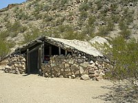
A kiva is a space used by Puebloans for rites and political meetings, many of them associated with the kachina belief system. Among the modern Hopi and most other Pueblo peoples, "kiva" means a large room that is circular and underground, and used for spiritual ceremonies.

<span class="mw-page-title-main">Sipapu</span> Small hole or indentation in the floor of a kiva

A sipapu was a small hole or indentation in the floor of a kiva (pithouse). Kivas were used by the Ancestral Puebloans and continue to be used by modern-day Puebloans. The sipapu symbolizes the portal through which their ancient ancestors first emerged to enter the present world.

<span class="mw-page-title-main">Hovenweep National Monument</span> US national monument

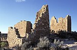
Hovenweep National Monument is located on land in southwestern Colorado and southeastern Utah, between Cortez, Colorado and Blanding, Utah on the Cajon Mesa of the Great Sage Plain. Shallow tributaries run through the wide and deep canyons into the San Juan River.

<span class="mw-page-title-main">Yucca House National Monument</span> Archaeological site in Colorado, United States

Yucca House National Monument is a United States National Monument located in Montezuma County, Colorado between the towns of Towaoc and Cortez, Colorado. Yucca House is a large, unexcavated Ancestral Puebloan archaeological site.

<span class="mw-page-title-main">Hawkins Preserve</span>

Hawkins Preserve is a 122-acre (0.49 km2) property within the city limits of Cortez, Colorado. It is protected by a conservation easement held by the Montezuma Land Conservancy.

<span class="mw-page-title-main">Canyons of the Ancients National Monument</span> Monument protecting significant sites of ancient Native Americans

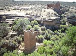
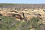
Canyons of the Ancients National Monument is a national monument protecting an archaeologically significant landscape located in the southwestern region of the U.S. state of Colorado. The monument's 176,056 acres (71,247 ha) are managed by the Bureau of Land Management, as directed in the presidential proclamation which created the site on June 9, 2000. Canyons of the Ancients National Monument is part of the National Landscape Conservation System, better known as the National Conservation Lands. This system comprises 32 million acres managed by the Bureau of Land Management to conserve, protect, and restore these nationally significant landscapes recognized for their outstanding cultural, ecological, and scientific values. Canyons of the Ancients encompasses and surrounds three of the four separate sections of Hovenweep National Monument, which is administered by the National Park Service. The monument was proclaimed in order to preserve the largest concentration of archaeological sites in the United States, primarily Ancestral Puebloan ruins. As of 2022, over 8,500 individual archeological sites had been documented within the monument.

<span class="mw-page-title-main">Lowry Pueblo</span> Archaeological site in Colorado, United States

The Lowry Pueblo is an Ancestral Puebloan archaeological site located in Canyons of the Ancients National Monument near Pleasant View, Colorado, United States. The pueblo was constructed around 1060 AD atop abandoned pithouses from an earlier period of occupation. It was occupied by 40 to 100 people at a time for 165 years. The site is one of the northernmost to be associated with the Puebloan cultures. The site was declared a National Historic Landmark in 1964.

<span class="mw-page-title-main">Trail of the Ancients</span> National Scenic Byways in Arizona, Colorado, New Mexico, and Utah, United States

The Trail of the Ancients is a collection of National Scenic Byways located in the U.S. Four Corners states of Utah, Colorado, New Mexico, and Arizona. These byways comprise:

<span class="mw-page-title-main">Canyons of the Ancients Visitor Center and Museum</span> Archaeological museum in Dolores, Colorado

The Canyons of the Ancients Visitor Center and Museum located in Dolores, Colorado, is an archaeological museum of Native American pueblo and hunter-gatherer cultures. Two 12th-century archaeological sites, the Escalante and Dominguez Pueblos, at the center were once home to Ancient Pueblo peoples. The museum's permanent and special exhibits display some of the 3 million mostly Ancestral Puebloan artifacts curated at the facility. The center also houses a public research library, educational resources and a museum shop. Wheelchair-accessible facilities include a picnic area and an interpreted nature and cultural trail.

<span class="mw-page-title-main">Ancestral Puebloan dwellings</span> Ancestral Puebloan homes

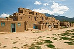
Hundreds of Ancestral Puebloan dwellings are found across the American Southwest. With almost all constructed well before 1492 CE, these Puebloan towns and villages are located throughout the geography of the Southwest.

<span class="mw-page-title-main">Ansel Hall Ruin</span> Archaeological site in Colorado, United States

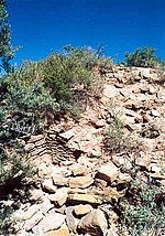
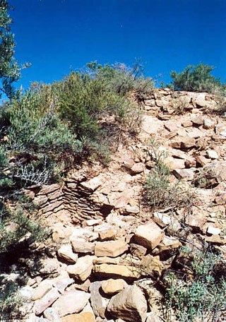
The Ansel Hall Ruin, also known as Cahone Ruin, is located in Cahone, Dolores County, Colorado. A pre-historic ruins from the Pueblo II period, the Northern San Juan pueblo was added to the National Register of Historic Places in 1997.

<span class="mw-page-title-main">Pueblo I Period</span> Era in the history of the Pueblo peoples

The Pueblo I Period was the first period in which Ancestral Puebloans began living in pueblo structures and realized an evolution in architecture, artistic expression, and water conservation.

<span class="mw-page-title-main">Pueblo II Period</span> Era in the history of the Pueblo peoples

The Pueblo II Period was the second pueblo period of the Ancestral Puebloans of the Four Corners region of the American southwest. During this period people lived in dwellings made of stone and mortar, enjoyed communal activities in kivas, built towers and dams for water conservation, and implemented milling bins for processing maize. Communities with low-yield farms traded pottery with other settlements for maize.

<span class="mw-page-title-main">Pueblo III Period</span> Era in the history of the Pueblo peoples

The Pueblo III Period was the third period, also called the "Great Pueblo period" when Ancestral Puebloans lived in large cliff-dwelling, multi-storied pueblo, or cliff-side talus house communities. By the end of the period, the ancient people of the Four Corners region migrated south into larger, centralized pueblos in central and southern Arizona and New Mexico.

<span class="mw-page-title-main">Pueblo IV Period</span> Era in the history of the Pueblo peoples

The Pueblo IV Period was the fourth period of ancient pueblo life in the American Southwest. At the end of prior Pueblo III Period, Ancestral Puebloans living in the Colorado and Utah regions abandoned their settlements and migrated south to the Pecos River and Rio Grande valleys. As a result, pueblos in those areas saw a significant increase in total population.

<span class="mw-page-title-main">Late Basketmaker II Era</span> Ancient culture of the southwest United States

The Late Basketmaker II Era was a cultural period of Ancient Pueblo People when people began living in pit-houses, raised maize and squash, and were proficient basket makers and weavers. They also hunted game and gathered wild foods, such as pinyon nuts.

<span class="mw-page-title-main">Outline of Colorado prehistory</span> Overview of and topical guide to the prehistory of Colorado

The following outline is provided as an overview of and topical guide to the prehistoric people of Colorado, which covers the period of when Native Americans lived in Colorado prior to contact with the Domínguez–Escalante expedition in 1776. People's lifestyles included nomadic hunter-gathering, semi-permanent village dwelling, and residing in pueblos.

<span class="mw-page-title-main">Mesa Verde region</span>

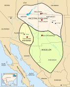
The Mesa Verde Region is a portion of the Colorado Plateau in the United States that extends through parts of New Mexico, Colorado and Utah. It is bounded by the San Juan River to the south, the Piedra River to the east, the San Juan Mountains to the north and the Colorado River to the west.

<span class="mw-page-title-main">Ancestral Puebloans</span> Ancient Native American culture in Four Corners region of the US

The Ancestral Puebloans, also known as the Anasazi, were an ancient Native American culture that spanned the present-day Four Corners region of the United States, comprising southeastern Utah, northeastern Arizona, northwestern New Mexico, and southwestern Colorado. They are believed to have developed, at least in part, from the Oshara tradition, which developed from the Picosa culture. The people and their archaeological culture are often referred to as Anasazi, meaning "ancient enemies", as they were called by Navajo. Contemporary Puebloans object to the use of this term, with some viewing it as derogatory.

References

  1. Rohn, Arthur H.; Ferguson, William M. Puebloan ruins of the Southwest. University of New Mexico Press, 2006. pp. 43. ISBN   0-8263-3969-7.
  2. 1 2 Wenger, Gilbert R. (1991) [1980]. The Story of Mesa Verde National Park. Mesa Verde Museum Park, Colorado: Mesa Verde Museum Association. pp. 39-45.
  3. History & Culture. Archived 2011-10-28 at the Wayback Machine National Park Service. Retrieved 9-20-2011.
  4. Stuart, Moczygemba-McKinsey, pp. 56-57.
  5. Pueblo Indian History. Archived 2011-10-08 at the Wayback Machine Crow Canyon Archaeological Center. Retrieved 10-9-2011.
  6. Lancaster, James A.; Pinkley, Jean M. Excavation at Site 16 of three Pueblo II Mesa-Top Ruins. Archived 2014-01-07 at the Wayback Machine Archeological Excavations in Mesa Verde National Park, Colorado. National Park Service. May 19, 2008. Retrieved 10-9-2011.
  7. 1 2 Pueblo III - Overview. Archived 2011-09-25 at the Wayback Machine Crow Canyon Archaeological Center. 2011. Retrieved 9-27-2011.
  8. "DeWitt Colony Life" Archived 2010-12-05 at the Wayback Machine . Texas A&M University. Retrieved July 27, 2011.
  9. "Chimney Rock Archaeological Area.". Archived from the original on 2012-01-02. Retrieved 2011-12-12.
  10. Cordell, Gumerman, p. 161.
  11. 1 2 3 4 5 6 7 8 Aldenderfer, Mark S.; Maschner, Herber D. G. (1996). Anthropology, Space and Geographic Information Systems. Oxford University Press. p. 127. ISBN   0-19-508575-2.
  12. Regional Context: Architecture, Settlement Patterns, and Abandonment. Archived 2011-07-01 at the Wayback Machine Crow Canyon Archaeological Center. 2011. Retrieved 9-26-2011.
  13. National & State Registers for Dolores County, Colorado. Archived 2012-04-24 at the Wayback Machine Colorado Historical Society, Office of Archaeology and Historic Preservation. Retrieved 10-8-2011.
  14. Varien, Mark D.; Wilshusen, Richard H. (editors). (2002). Seeking the Center Place, Archaeology and Ancient Communities in the Mesa Verde Region. University of Utah Press. p. 210. ISBN   0-87480-735-2.
  15. Dove, Donald E. Greenlee Ruins Conclusions and Recommendations. Archived 2012-04-02 at the Wayback Machine Colorado Archaeology Society. 2011. Retrieved 9-27-2011.
  16. 1 2 3 Colorado State Register of Historic Places for LaPlata County, Colorado. Archived 2012-04-24 at the Wayback Machine Colorado Historical Society. Retrieved December 13, 2011.
  17. 1 2 3 4 5 6 7 8 9 10 11 12 13 14 15 "National Register Information System". National Register of Historic Places . National Park Service. July 9, 2010.
  18. 1 2 "What is unique about the Escalante and Dominguez Pueblos?". U.S. Department of the Interior, Bureau of Land Management. 2011-08-08. Archived from the original on 2011-07-02. Retrieved 2011-06-18.
  19. "Mesa Verde County Archaeology: Anasazi Heritage Center". Mesa Verde Country Visitor Information Bureau. 1995–2011. Archived from the original on 2011-04-27. Retrieved 2011-06-18.
  20. 1 2 Canyons of the Ancients Visitor Information. Archived 2016-09-30 at the Wayback Machine Bureau of Land Management. Retrieved 9-24-2011.
  21. Plog, Stephen. (1997). Ancient Peoples of the American Southwest. London: Thames and Hudson. ISBN   0-500-02116-3.
  22. Gregory, Lee. Colorado Scenic Guide: Southern Region. Johnson Books, Boulder, Colorado, 1996 (1st edition 1984). pp. 17-18. ISBN   1-55566-145-9.
  23. Casey, Robert. L. (1993) [1983]. High Journey to the Southwest. The Globe Pequot Press. p. 229. ISBN   1-56440-151-0.
  24. Hawkins Preserve: Research. Archived 2012-03-06 at the Wayback Machine Cortez Cultural Center. 2011. Retrieved 9-26-2011.
  25. Cajon Group Archived 2011-09-03 at the Wayback Machine . National Park Service. Retrieved 9-20-2011.
  26. Winter, Joseph (1975). Hovenweep 1974: Archeological Report No.1. San Jose, CA: Anthropology Department, San Jose State University.
  27. Winter, Joseph (1976). Hovenweep 1975 Archeological Report no.2. San Jose, CA: Anthropology Dept, San Jose State University.
  28. Most information from this section can be found here:Ferguson, William (1987). Anasazi Ruins of the Southwest in Color. Albuquerque: University of New Mexico Press. ISBN   0-8263-0873-2.
  29. Goodman Point. Archived 2011-09-03 at the Wayback Machine National Park Service. Retrieved 9-20-2011.
  30. 1 2 Hovenweep Visitor Guide Archived 2011-12-16 at the Wayback Machine National Park Service. Retrieved 9-20-2011.
  31. The Hovenweep Visitor's Guide published by the National Park Service does not include Goodman Point, [30]
  32. 1 2 Rohn, Arthur H.; Ferguson, William M. Puebloan ruins of the Southwest. University of New Mexico Press, 2006. p. 157. ISBN   0-8263-3969-7.
  33. 1 2 Horseshoe and Hackberry Groups. Archived 2011-09-03 at the Wayback Machine National Park Service. Retrieved 9-20-2011.
  34. Holly Ruin. Archived 2011-09-03 at the Wayback Machine National Park Service. Retrieved 9-20-2011.
  35. Frazier, Kendrick. People of Chaco: A Canyon and Its Culture. W.W. Norton and Company, New York, 1986. p. 200. ISBN   0-393-30496-5.
  36. Rohn, Arthur H.; Ferguson, William M. Puebloan ruins of the Southwest. University of New Mexico Press, 2006. p. 153. ISBN   0-8263-3969-7.
  37. Square Tower. Archived 2011-09-03 at the Wayback Machine National Park Service. Retrieved 9-20-2011.
  38. Little Ruin Canyon Trail Guide. Archived 2012-11-08 at the Wayback Machine National Park Service. Retrieved 9-20-2011.
  39. 1 2 Gibbon, Guy E.; Ames, Kenneth M. (1998) Archaeology of Prehistoric Native America: An Encyclopedia. Archived 2016-05-19 at the Wayback Machine p. 377. ISBN   0-8153-0725-X.
  40. Frazier, Kendrick. People of Chaco: A Canyon and Its Culture. W.W. Norton and Company, New York, 1986. pp. 199-200. ISBN   0-393-30496-5.
  41. Great Period of the McElmo Drainage Unit, A.D. 1075-1300. Archived 2012-04-24 at the Wayback Machine National Register of Historic Places, Multiple Property Documentation Form. pp. 1, 3, 8. Retrieved December 13, 2011.
  42. 1 2 3 4 5 6 7 8 9 10 11 12 National & State Registers. Archived 2012-04-24 at the Wayback Machine Colorado Historical Society, Office of Archaeology and Historic Preservation. Retrieved 10-7-2011.
  43. Wenger, Gilbert R. (1991) [1980]. The Story of Mesa Verde National Park. Mesa Verde Museum Park, Colorado: Mesa Verde Museum Association. pp. 55-56. ISBN   0-937062-15-4.
  44. Casey, Robert. L. (1993) [1983]. High Journey to the Southwest. The Globe Pequot Press. pp. 225-226. ISBN   1-56440-151-0.
  45. Balcony House. Archived 2011-08-04 at the Wayback Machine Mesa Verde National Park. Retrieved 9-21-2011.
  46. Watson, Don. Indians of the Mesa Verde. Mesa Verde National Park, Colorado: Mesa Verde Museum Association. pp. 3, 29, 31, 37. ISBN   0-937062-00-6.
  47. Wenger, Gilbert R. (1991) [1980]. The Story of Mesa Verde National Park. Mesa Verde Museum Park, Colorado: Mesa Verde Museum Association. p. 51. ISBN   0-937062-15-4.
  48. Wenger, Gilbert R. (1991) [1980]. The Story of Mesa Verde National Park. Mesa Verde Museum Park, Colorado: Mesa Verde Museum Association. p. 57. ISBN   0-937062-15-4.
  49. New 2011 Backcountry Hikes. Archived 2012-11-08 at the Wayback Machine National Park Service. Retrieved 9-24-2011.
  50. Spruce Tree House. Archived 2011-08-04 at the Wayback Machine Mesa Verde National Park. Retrieved 9-21-2011.
  51. Wenger, Gilbert R. (1991) [1980]. The Story of Mesa Verde National Park. Mesa Verde Museum Park, Colorado: Mesa Verde Museum Association. p. 52. ISBN   0-937062-15-4.
  52. 1 2 Self-Guided Tours: Chapin Mesa. Archived 2011-09-26 at the Wayback Machine Mesa Verde National Park. Retrieved 9-21-2011.
  53. Cassells, E. Steve. (1997). The Archeology of Colorado, Revised Edition. Boulder, Colorado: Johnson Books. pp. 162. ISBN   1-55566-193-9.
  54. National & State Registers for Montezuma County, Colorado. Archived 2012-04-24 at the Wayback Machine Colorado Historical Society, Office of Archaeology and Historic Preservation. Retrieved 10-8-2011.
  55. <<</state.html National Register of Historic Places in <<< County [ permanent dead link ] American Dreams, Inc. Retrieved 2011-10-6.
  56. 1 2 National & State Registers. Archived 2012-04-24 at the Wayback Machine Colorado Historical Society, Office of Archaeology and Historic Preservation. Retrieved 10-8-2011.
38°59′50″N105°32′52″W / 38.9972°N 105.5478°W / 38.9972; -105.5478 (State of Colorado)