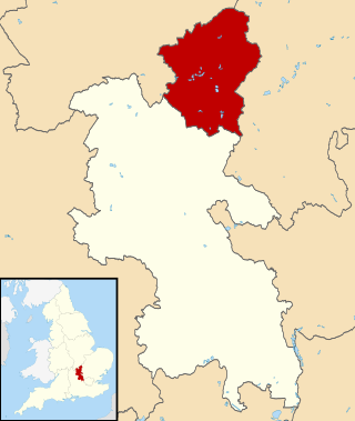
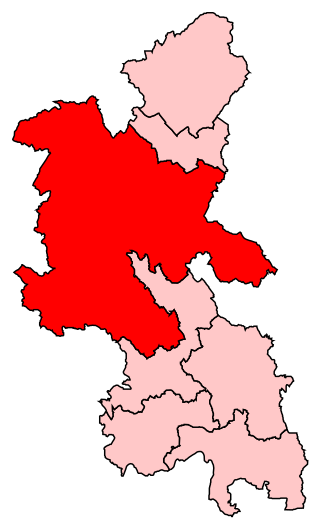
The City of Milton Keynes is a unitary authority area with both borough and city status, in Buckinghamshire. It is the northernmost district of the South East England Region. The borough abuts Bedfordshire, Northamptonshire and the remainder of Buckinghamshire.

Hanslope is a village and civil parish in the unitary authority area of the City of Milton Keynes, Buckinghamshire, England. The village is about 4 miles (6.4 km) west northwest of Newport Pagnell, about 4 miles (6.4 km) north of Stony Stratford and 8 miles (13 km) north of Central Milton Keynes. The northern parish boundary is part of the county boundary with Northamptonshire.

North East Milton Keynes was a county constituency represented in the House of Commons of the Parliament of the United Kingdom from 1992 to 2010. It elected one member of parliament (MP) by the first past the post system of election.

Milton Keynes South West was a constituency represented in the House of Commons of the Parliament of the United Kingdom from 1992 to 2010. It elected one Member of Parliament (MP) by the first past the post system of election.
Buckingham is a constituency represented in the House of Commons of the UK Parliament since 2019 by Greg Smith, a Conservative.

Newport Pagnell was a rural district in the administrative county of Buckinghamshire, England, from 1894 to 1974, covering an area in the north-east of the county.

New Bradwell is (mainly) an Edwardian era village, modern district and civil parish in north-west Milton Keynes, Buckinghamshire, England. Together with Wolverton, it was built primarily to house the workers on the Wolverton railway works.

Milton Keynes was a borough constituency represented in the House of Commons of the Parliament of the United Kingdom from 1983 until 1992.

Milton Keynes North is a constituency represented in the House of Commons of the UK Parliament since the 2019 United Kingdom general election by Ben Everitt, a Conservative.

Milton Keynes South is a constituency represented in the House of Commons of the UK Parliament since its 2010 creation by Iain Stewart, a Conservative.

The Milton Keynes redway system is an over 200 miles network of shared use paths for cyclists and pedestrians in Milton Keynes, Buckinghamshire, England. It is generally surfaced with red tarmac, and criss-crosses most of the city.
Sport in Milton Keynes covers a range of professional and amateur sport in the City of Milton Keynes unitary authority area. In 2019, Milton Keynes was officially designated as a European City of Sport for 2020. There are professional teams in football, in motorsport and in ice hockey. The National Badminton Centre, and the Marshall Milton Keynes Athletic Club train professional and amateur athletes. Most other sports feature at amateur level although there are semi-professional teams in rugby union and football among other sports. There is an international-standard karting track owned by Daytona Motorsport.

This history of Milton Keynes details its development from the earliest human settlements, through the plans for a 'new city' for 250,000 people in northern Southeast England, its subsequent urban design and development, to the present day. Milton Keynes is the largest settlement and only city in Buckinghamshire, founded in 1967. At the 2021 census, the population of its urban area was estimated to have exceeded 256,000.

MK Metro was a bus company operating in Milton Keynes from 1997 until 2010.

Milton Keynes City Council is the local authority of the City of Milton Keynes in Buckinghamshire, England. It is a unitary authority, having the powers of a non-metropolitan county and district council combined. It has both borough status and city status. The borough is divided into 19 wards, electing 57 councillors.

The Milton Keynes grid road system is a network of predominantly national speed limit, fully landscaped routes that form the top layer of the street hierarchy for both private and public transport in Milton Keynes, Buckinghamshire. The system is unique in the United Kingdom for its innovative use of street hierarchy principles: the grid roads run in between districts rather than through them. This arrangement permits higher speed limits due to the absence of buildings close to the roads – although more recently some have been limited in part to 40 mph (64 km/h). The grid road system also serves an important purpose of discouraging through-traffic from travelling through neighborhoods and thus reduces traffic noise and pollution from pedestrian areas. Motor traffic is segregated from pedestrian and leisure cycling traffic, which uses the alternative Milton Keynes redway system. Almost all grid junctions are roundabouts, and the absence of traffic lights enables free and efficient movement of traffic.
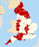
 2002 results map
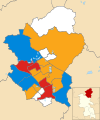 2003 results map
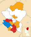 2004 results map
 2006 results map
 2007 results map
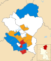 2008 results map
 2010 results map
 2011 results map
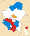 2012 results map
 2014 results map
 2015 results map
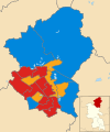 2016 results map
 2018 results map
 2019 results map
 2021 results map