Morgan Park, Queensland

Last updated

Morgan Park
Queensland
Australia Queensland location map.svg
Red pog.svg
Morgan Park
Coordinates 28°15′29″S152°02′34″E / 28.2580°S 152.0427°E / -28.2580; 152.0427 (Morgan Park (centre of locality))
Population98 (2021 census) [1]
 • Density7.15/km2 (18.53/sq mi)
Postcode(s) 4370
Area13.7 km2 (5.3 sq mi)
Time zone AEST (UTC+10:00)
Location
LGA(s) Southern Downs Region
State electorate(s) Southern Downs
Federal division(s) Maranoa
Suburbs around Morgan Park:
Rosenthal Heights Warwick Canningvale
Rosenthal Heights Morgan Park Canningvale
Silverwood Wildash Wildash

Morgan Park is a rural locality in the Southern Downs Region, Queensland, Australia. [2] In the 2021 census, Morgan Park had a population of 98 people. [1]

Contents

Geography

The locality is immediately south of the town of Warwick. It is bounded to the north by Bracker Road and Warwick - Killarney Road, to the north-east by Warwick - Killarney Road, to the east by Bentley Road, to the south-east by Pierce Road, to the south partially by Morgan Park Road, and to the south-west, west, and north-west by the South Western railway line. [3]

The Morgan Park Conservation Park is in the south of the locality. [3] It protectes an ecosystem of Eucalyptus moluccana and Eucalyptus microcarpa open forest and two migratory bird species, the rainbow bee-eater ( Merops ornatus ) and the rufous fantail ( Rhipidura rufifrons ). [4]

The centre and west of the locality is occupied by the identically named Morgan Park, a reserve for sports and recreation ( 28°15′37″S152°02′06″E / 28.2604°S 152.0350°E / -28.2604; 152.0350 (Morgan Park (recreation reserve)) ). [5]

The north of the locality includes a waste disposal landfill and an industrial area.The remainder of the locality is predominantly used for grazing on native vegetation. [3]

History

The locality takes its name from the now-abandoned Morgan Park railway station ( 28°16′01″S152°00′54″E / 28.26687°S 152.01497°E / -28.26687; 152.01497 (Morgan Park railway station (former)) ) on the South Western railway line, which was named after James Morgan, a politician and newspaper owner. [2] [6]

Demographics

In the 2016 census, Morgan Park had a population of 86 people. [7]

In the 2021 census, Morgan Park had a population of 98 people. [1]

Demographics

In the 2016 census, Morgan Park had a population of 86 people. [7]

In the 2021 census, Morgan Park had a population of 98 people. [1]

Education

There are no school in Morgan Park. The nearest government primary schools are Warwick East State School and Warwick West State School, both in neighbouring Warwick to the north, and Murray's Bridge State School in Murrays Bridge to the south-east. The nearest government secondary school is Warwick State High School, also in Warwick. [8]

Amenities

The park Morgan Park off Old Stanthorpe Road is operated by the Southern Downs Regional Council and has a number of recreational facilities, including: [9]

Morgan Park Conservation Park is used for birdwatching with many species of birds to be seen. [9]

Facilities

Warwick Waste Facility is a landfill on Old Stanthorpe Road. It is operated by the Southern Downs Regional Council. [11]

Related Research Articles

<span class="mw-page-title-main">Stanthorpe, Queensland</span> Town in Queensland, Australia

Stanthorpe is a rural town and locality in the Southern Downs Region, Queensland, Australia. In the 2021 census, the locality of Stanthorpe had a population of 5,286 people.

<span class="mw-page-title-main">Killarney, Queensland</span> Town in Queensland, Australia

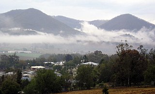
Killarney is a rural town and locality in the Southern Downs Region, Queensland, Australia. It borders New South Wales. In the 2021 census, the locality of Killarney had a population of 918 people.

<span class="mw-page-title-main">Maryvale, Queensland (Southern Downs Region)</span> Town in Queensland, Australia

Maryvale is a rural town and locality in the Southern Downs Region, Queensland, Australia. In the 2021 census, the locality of Maryvale had a population of 392 people.

<span class="mw-page-title-main">Applethorpe, Queensland</span> Town in Queensland, Australia

Applethorpe is a rural town and locality in the Southern Downs Region, Queensland, Australia. It is on Queensland's border with New South Wales. It is well known for the production of apples. It often records the lowest temperatures in Queensland.

<span class="mw-page-title-main">Dalveen, Queensland</span> Town in Queensland, Australia

Dalveen is a town and a locality in the Southern Downs Region, Queensland, Australia. It borders New South Wales. In the 2021 census, the locality of Dalveen had a population of 369 people.

<span class="mw-page-title-main">Swan Creek, Queensland</span> Suburb of Southern Downs Region, Queensland, Australia

Swan Creek is a rural locality in the Southern Downs Region, Queensland, Australia. In the 2021 census, Swan Creek had a population of 161 people.

<span class="mw-page-title-main">Yangan, Queensland</span> Town in Queensland, Australia

Yangan is a rural town and locality in the Southern Downs Region, Queensland, Australia. In the 2021 census, the locality of Yangan had a population of 404 people.

<span class="mw-page-title-main">The Summit, Queensland</span> Town in Queensland, Australia

The Summit is a rural town and locality in the Southern Downs Region, Queensland, Australia. In the 2021 census, the locality of The Summit had a population of 436 people.

<span class="mw-page-title-main">Lyra, Queensland</span> Suburb of Southern Downs Region, Queensland, Australia

Lyra is a rural locality in the Southern Downs Region, Queensland, Australia. In the 2021 census, Lyra had a population of 35 people.

<span class="mw-page-title-main">Tannymorel, Queensland</span> Town in Queensland, Australia

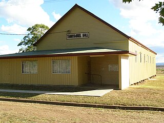
Tannymorel is a rural town and locality in the Southern Downs Region, Queensland, Australia. In the 2021 census, the locality of Tannymorel had a population of 148 people.

Glen Aplin is a rural locality in the Southern Downs Region, Queensland, Australia. In the 2021 census, Glen Aplin had a population of 566 people.

<span class="mw-page-title-main">Clintonvale, Queensland</span> Suburb of Southern Downs Region, Queensland, Australia

Clintonvale is a rural locality in the Southern Downs Region, Queensland, Australia. In the 2021 census, Clintonvale had a population of 72 people.

<span class="mw-page-title-main">Danderoo, Queensland</span> Suburb of Southern Downs Region, Queensland, Australia

Danderoo is a rural locality in the Southern Downs Region, Queensland, Australia. In the 2021 census, Danderoo had a population of 40 people.

Elbow Valley is a rural locality in the Southern Downs Region, Queensland, Australia. It is on the border of New South Wales. In the 2021 census, Elbow Valley had a population of 127 people.

<span class="mw-page-title-main">Emu Vale, Queensland</span> Town in Queensland, Australia

Emu Vale is a rural town and locality in the Southern Downs Region, Queensland, Australia. In the 2021 census, the locality of Emu Vale had a population of 161 people.

<span class="mw-page-title-main">Goomburra, Queensland</span> Town in Queensland, Australia

Goomburra is a rural town and locality in the Southern Downs Region, Queensland, Australia. In the 2021 census, the locality of Goomburra had a population of 256 people.

Loch Lomond is a rural locality in the Southern Downs Region, Queensland, Australia. In the 2021 census, Loch Lomond had a population of 119 people.

The Head is a rural locality in the Southern Downs Region, Queensland, Australia. It borders New South Wales. In the 2021 census, The Head had a population of 12 people.

<span class="mw-page-title-main">Silverwood, Queensland</span> Suburb of Southern Downs Region, Queensland, Australia

Silverwood is a rural locality in the Southern Downs Region, Queensland, Australia. In the 2021 census, Silverwood had a population of 58 people.

Sugarloaf is a rural locality in the Southern Downs Region, Queensland, Australia. In the 2021 census, Sugarloaf had a population of 162 people.

References

  1. 1 2 3 4 Australian Bureau of Statistics (28 June 2022). "Morgan Park (SAL)". 2021 Census QuickStats. Retrieved 28 February 2023. OOjs UI icon edit-ltr-progressive.svg
  2. 1 2 "Morgan Park – locality in Southern Downs Region (entry 45954)". Queensland Place Names. Queensland Government . Retrieved 11 June 2019.
  3. 1 2 3 "Queensland Globe". State of Queensland . Retrieved 5 December 2023.
  4. "Morgan Park Regional Park Management Statement" (PDF). Parks and forests. Queensland Government. 2015. Archived (PDF) from the original on 18 March 2023. Retrieved 6 December 2023.
  5. "Land for public recreation - Queensland". Queensland Open Data. Queensland Government. 20 November 2020. Archived from the original on 22 November 2020. Retrieved 22 November 2020.
  6. "Railway stations and sidings - Queensland". Queensland Open Data. Queensland Government. 2 October 2020. Archived from the original on 5 October 2020. Retrieved 5 October 2020.
  7. 1 2 Australian Bureau of Statistics (27 June 2017). "Morgan Park (SSC)". 2016 Census QuickStats. Retrieved 20 October 2018. OOjs UI icon edit-ltr-progressive.svg
  8. "Layers: Locality; Schools and school catchments". Queensland Globe. Queensland Government. Archived from the original on 19 December 2017. Retrieved 5 December 2023.
  9. 1 2 "Morgan Park". Southern Downs Regional Council. Archived from the original on 28 October 2023. Retrieved 5 December 2023.
  10. "Warwick Aero Modellers". Warwick Aero Modellers. Archived from the original on 30 May 2023. Retrieved 5 December 2023.
  11. "Warwick Central Waste Management Facility". Southern Downs Regional Council. Archived from the original on 28 October 2023. Retrieved 5 December 2023.