A request that this article title be changed to Ottawa, Illinois, micropolitan area is under discussion . Please do not move this article until the discussion is closed. |
Ottawa, IL Micropolitan Statistical Area | ||
|---|---|---|
 LaSalle County Courthouse in Ottawa | ||
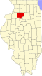
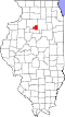
 Interactive Map of Ottawa, IL μSA | ||
| Country | | |
| State | | |
| Principal city | Ottawa | |
| Other city | Streator | |
| Time zone | UTC−6 (CST) | |
| • Summer (DST) | UTC−5 (CDT) | |
The Ottawa, Illinois, micropolitan area, [1] as defined by the United States Census Bureau, is an area consisting of three counties in Northern Illinois, anchored by the city of Ottawa. Peru (until 2020) and Streator (until 2013) are former primary cities.
Contents
- Counties
- Communities
- Places with more than 10,000 inhabitants
- Places with 5,000 to 10,000 inhabitants
- Places with 1,000 to 5,000 inhabitants
- Places with 500 to 1,000 inhabitants
- Places with less than 500 inhabitants
- Unincorporated places
- Townships
- Bureau County
- LaSalle County
- Putnam County
- Demographics
- See also
- Notes
- References
As of the 2010 census, the μSA had a population of 154,908. [2] An estimate by the Census Bureau, as of July 1, 2012, placed the population at 153,182, a decrease of 1.11%, but still making it the fourth-largest micropolitan statistical area in the United States. [2]