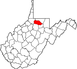
Pleasant Valley, Marion County, West Virginia

Last updated

Pleasant Valley, West Virginia
Flag of Pleasant Valley, Marion County, West Virginia.svg
Seal of Pleasant Valley, West Virginia.png
Marion County West Virginia Incorporated and Unincorporated areas Pleasant Valley Highlighted.svg
Location of Pleasant Valley in Marion County, West Virginia.
Coordinates: 39°27′5″N80°8′57″W / 39.45139°N 80.14917°W / 39.45139; -80.14917
Country United States
State West Virginia
County Marion
Incorporated 1995 [1]
Government
  Type Strong Mayor-Council Government [2]
  MayorEmily Haddix
Area
[3]
  Total3.41 sq mi (8.82 km2)
  Land3.23 sq mi (8.37 km2)
  Water0.18 sq mi (0.45 km2)
Elevation
1,030 ft (314 m)
Population
 (2020) [4]
  Total3,506
  Estimate 
(2021) [4]
3,492
  Density972.14/sq mi (375.35/km2)
Time zone UTC-5 (Eastern (EST))
  Summer (DST) UTC-4 (EDT)
ZIP codes
26554-26555
Area code 304
FIPS code 54-64228 [5]
GNIS feature ID1555370 [6]
Website http://www.cityofpleasantvalley.com

Pleasant Valley is a city in Marion County, West Virginia, United States. The population was 3,506 at the 2020 census. [4]

Contents

Geography

Pleasant Valley is located at 39°27′5″N80°8′57″W / 39.45139°N 80.14917°W / 39.45139; -80.14917 (39.451522, -80.149085). [7] It is immediately south of the larger city and county seat of Fairmont, West Virginia. The city is also adjacent to the Tygart Valley River.

According to the United States Census Bureau, the city has a total area of 3.41 square miles (8.83 km2), of which 3.23 square miles (8.37 km2) is land and 0.18 square miles (0.47 km2) is water. [8]

Transportation

Demographics

Historical population
CensusPop.Note
2000 3,124
2010 3,1490.8%
2020 3,50611.3%
2021 (est.)3,492 [4] −0.4%
U.S. Decennial Census [10]

The median income for a household in the city was $37,931, and the median income for a family was $47,330. Full-time, year-round male workers had a median income of $45,234 versus $37,132 for female workers. The per capita income for the city was $22,335. About 9.7% of families and 16.3% of the population were below the poverty line, including 19.8% of those under age 18 and 8.4% of those age 65 or over.

2010 census

As of the census [11] of 2010, there were 3,149 people, 1,401 households, and 870 families living in the city. The population density was 974.9 inhabitants per square mile (376.4/km2). There were 1,513 housing units at an average density of 468.4 per square mile (180.9/km2). The racial makeup of the city was 95.9% White, 1.4% African American, 0.1% Native American, 1.1% Asian, 0.2% from other races, and 1.3% from two or more races. Hispanic or Latino of any race were 0.6% of the population.

There were 1,401 households, of which 26.1% had children under the age of 18 living with them, 47.0% were married couples living together, 11.1% had a female householder with no husband present, 4.0% had a male householder with no wife present, and 37.9% were non-families. 30.8% of all households were made up of individuals, and 12.4% had someone living alone who was 65 years of age or older. The average household size was 2.21 and the average family size was 2.76.

The median age in the city was 40.5 years. 21.2% of residents were under the age of 18; 8% were between the ages of 18 and 24; 26.2% were from 25 to 44; 28.1% were from 45 to 64; and 16.6% were 65 years of age or older. The gender makeup of the city was 48.9% male and 51.1% female.

Related Research Articles

<span class="mw-page-title-main">Pleasants County, West Virginia</span> County in West Virginia, United States

Pleasants County is a county located in the U.S. state of West Virginia. At the 2020 census, the population was 7,653. Its county seat is St. Marys.

<span class="mw-page-title-main">Marion County, West Virginia</span> County in West Virginia, United States

Marion County is a county in the U.S. state of West Virginia. As of the 2020 census, the population was 56,205. Its county seat is Fairmont. The county was named in honor of General Francis Marion, known to history as "The Swamp Fox". Marion County comprises the Fairmont, WV Micropolitan Statistical Area, which is part of the larger Morgantown–Fairmont, WV Combined Statistical Area.

<span class="mw-page-title-main">Lewis County, West Virginia</span> County in West Virginia, United States

Lewis County is a county in the U.S. state of West Virginia. As of the 2020 census, the population was 17,033. Its county seat is Weston. The county was formed in 1816 from Harrison County and named for Col. Charles Lewis (1733–1774), a Virginian killed in the Battle of Point Pleasant.

<span class="mw-page-title-main">Daniels County, Montana</span> County in Montana, United States

Daniels County is a county located in the U.S. state of Montana. As of the 2020 census, the population was 1,661. Its county seat is Scobey. It is on Montana's north border, and thus abuts the Canada–US border with Saskatchewan.

<span class="mw-page-title-main">Rainbow, California</span> Census designated place in California, United States

Rainbow is a census-designated place (CDP) in northern San Diego County, California. The population was 1,832 at the 2010 census, down from 2,026 at the 2000 census.

<span class="mw-page-title-main">Silver Springs Shores, Florida</span> Census-designated place in Florida, United States

Silver Springs Shores is a census-designated place (CDP) in Marion County, Florida, United States. The population was 24,846 at the 2020 census, up from 6,539 at the 2010 census. It is part of the Ocala, Florida Metropolitan Statistical Area.

<span class="mw-page-title-main">Fairmount, Georgia</span> City in Georgia, United States

Fairmount is a city in Gordon County, Georgia, United States. As of the 2010 census it had a population of 720. Gordon County is home to New Echota, which was once the Cherokee Nation's capital. It was the origin of the Cherokee written language and newspaper, the Cherokee Phoenix.

<span class="mw-page-title-main">Bellevue, Illinois</span> Village in Illinois, United States

Bellevue is a village in Peoria County, Illinois, United States. The population was 1,978 at the 2010 census. Bellevue is a suburb of Peoria and is part of the Peoria, Illinois Metropolitan Statistical Area.

<span class="mw-page-title-main">Valley City, Illinois</span> Village in Illinois, United States

Valley City is a village in Pike County, Illinois, United States. The population was 14 at the 2020 census, making Valley City the smallest incorporated place in Illinois in terms of population. As of 2024, the population is 13. In late December 2015 and early January 2016 the village flooded, leaving many roads underwater.

<span class="mw-page-title-main">Northrop, Minnesota</span> City in Minnesota, United States

Northrop is a city in Martin County, Minnesota, United States. The population was 223 at the 2020 census.

<span class="mw-page-title-main">Pleasant Valley, Missouri</span> Place in Missouri, United States

Pleasant Valley is a city in Clay County, Missouri, United States. The population was 2,743 at the 2020 census. It is part of the Kansas City metropolitan area.

<span class="mw-page-title-main">Red Oaks Mill, New York</span> Census-designated place in New York, United States

Red Oaks Mill is a hamlet and census-designated place (CDP) in Dutchess County, in the U.S. state of New York. It lies within the limits of the towns of Poughkeepsie and LaGrange. The population was 3,613 at the 2010 census.

<span class="mw-page-title-main">Pleasant City, Ohio</span> Village in Ohio, United States

Pleasant City is a village in Guernsey County, Ohio, United States. The population was 400 at the 2020 census.

<span class="mw-page-title-main">Mount Pleasant Township, Adams County, Pennsylvania</span> Township in Pennsylvania, United States

Mount Pleasant Township is a township that is located in Adams County, Pennsylvania, United States. As of the 2010 census, the township population was 4,693.

<span class="mw-page-title-main">Stonewood, West Virginia</span> City in West Virginia, United States

Stonewood is a city in Harrison County, West Virginia, United States. The population was 1,810 at the 2020 census.

<span class="mw-page-title-main">Grant Town, West Virginia</span> Town in West Virginia, United States

Grant Town is a town in Marion County, West Virginia, in the eastern United States. The population was 690 at the 2020 census.

<span class="mw-page-title-main">White Hall, West Virginia</span> Town in West Virginia, United States

White Hall is a town in Marion County, West Virginia, United States. The population was 706 at the 2020 census. Incorporated in 1989, White Hall is adjacent to the county seat, Fairmont, and is part of the Fairmont, West Virginia, Micropolitan Statistical Area. White Hall has many different stores and restaurants.

<span class="mw-page-title-main">Belmont, West Virginia</span> Town in West Virginia, United States

Belmont is a town in Pleasants County, West Virginia, United States. It is part of the Parkersburg–Vienna metropolitan area. The population was 872 at the 2020 census. Belmont was incorporated on April 19, 1946, by the Circuit Court of Pleasants County. The city was named for the beautiful hills in the area.

<span class="mw-page-title-main">Pine Grove, West Virginia</span> Town in West Virginia, United States

Pine Grove is a town in Wetzel County, West Virginia, United States. The population was 363 at the 2020 census. The community was named for a grove of pine trees near the original town site.

<span class="mw-page-title-main">Spring Valley, Wisconsin</span> Village in Wisconsin, United States

Spring Valley is a village in Pierce and St. Croix counties in Wisconsin, United States. The population was 1,401 at the 2020 census. Of those, 1,390 were in Pierce County and 11 in St. Croix County. The village is mostly within the Town of Spring Lake in Pierce County. Small parts also lie in the Town of Gilman, also in Pierce County, and the Town of Cady in St. Croix County.

References

  1. "HISTORY TO PRESENT… THIS IS PLEASANT VALLEY" . Retrieved August 3, 2023.
  2. "Elected Officials". City of Pleasant Valley, West Virginia. Retrieved March 31, 2012.
  3. "2019 U.S. Gazetteer Files". United States Census Bureau. Retrieved August 7, 2020.
  4. 1 2 3 4 Bureau, US Census. "City and Town Population Totals: 2020-2021". Census.gov. US Census Bureau. Retrieved July 3, 2022.{{cite web}}: |last1= has generic name (help)
  5. "U.S. Census website". United States Census Bureau . Retrieved January 31, 2008.
  6. "US Board on Geographic Names". United States Geological Survey. October 25, 2007. Retrieved January 31, 2008.
  7. "US Gazetteer files: 2010, 2000, and 1990". United States Census Bureau. February 12, 2011. Retrieved April 23, 2011.
  8. "US Gazetteer files 2010". United States Census Bureau. Archived from the original on January 25, 2012. Retrieved January 24, 2013.
  9. "Location Identifiers". Archived from the original on June 25, 2012. Retrieved March 31, 2012.
  10. "Census of Population and Housing". Census.gov. Retrieved June 4, 2015.
  11. "U.S. Census website". United States Census Bureau . Retrieved January 24, 2013.