Preston, Georgia

Last updated

Preston, Georgia
Preston, GA City Hall.JPG
Preston City Hall
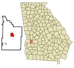
Webster County Georgia Incorporated and Unincorporated areas Preston Highlighted.svg
Location in Webster County and the state of Georgia
Coordinates: 32°3′39″N84°32′18″W / 32.06083°N 84.53833°W / 32.06083; -84.53833
Country United States
State Georgia
County Webster
Area
  Total4.5 sq mi (11.7 km2)
  Land4.5 sq mi (11.7 km2)
  Water0 sq mi (0 km2)
Elevation
459 ft (140 m)
Population
 (2000)
  Total453
  Density100.7/sq mi (38.7/km2)
Time zone UTC-5 (Eastern (EST))
  Summer (DST) UTC-4 (EDT)
ZIP code
31824
Area code 229
FIPS code 13-62720 [1]
GNIS feature ID0332757 [2]

Preston is an unincorporated community in Webster County, Georgia, United States, located seventeen miles west of Americus. The population was 453 at the 2000 census. From 1857 to 2009, Preston was an incorporated municipality. The community is the county seat of Webster County. [3]

Contents

History

Preston was founded in 1856 as the seat of Webster County. It was incorporated as a town in 1857 and as a city in 1977. [4] In 2009, the city was disincorporated and became part of the Unified Government of Webster County.

Geography

Preston is located at 32°3′39″N84°32′18″W / 32.06083°N 84.53833°W / 32.06083; -84.53833 (32.060789, -84.538287). [5]

U.S. Route 280, as well as Georgia State Routes 41 and 153, are the main highways through the community. U.S. Route 280 runs from east to west as Hamilton Street, leading east 9 mi (14 km) to Plains and west 9 mi (14 km) to Richland. GA-41 runs from south to north through the community and is briefly concurrent with U.S. 280 through the downtown area, leading north 19 mi (31 km) to Buena Vista and southwest 9 mi (14 km) to Weston. GA-153 begins just north of the community and leads northeast 20 mi (32 km) to Ellaville.

According to the United States Census Bureau, the town has a total area of 4.5 square miles (12 km2), all land.

Demographics

Historical population
CensusPop.Note
1870 186
1880 139−25.3%
1900 146
1910 25977.4%
1920 252−2.7%
1930 32127.4%
1940 3498.7%
1950 260−25.5%
1960 232−10.8%
1970 226−2.6%
1980 42989.8%
1990 388−9.6%
2000 45316.8%
U.S. Decennial Census [6]

As of the census [1] of 2000, there were 453 people, 190 households, and 129 families residing in the town. The population density was 100.1 inhabitants per square mile (38.6/km2). There were 205 housing units at an average density of 45.3 per square mile (17.5/km2). The racial makeup of the town was 67.77% White, 28.26% African American, 0.22% Native American, 3.53% from other races, and 0.22% from two or more races. Hispanic or Latino of any race were 3.75% of the population.

There were 190 households, out of which 30.0% had children under the age of 18 living with them, 50.0% were married couples living together, 15.3% had a female householder with no husband present, and 31.6% were non-families. 30.5% of all households were made up of individuals, and 19.5% had someone living alone who was 65 years of age or older. The average household size was 2.37 and the average family size was 2.93.

In the town the population was spread out, with 24.5% under the age of 18, 7.9% from 18 to 24, 27.2% from 25 to 44, 22.3% from 45 to 64, and 18.1% who were 65 years of age or older. The median age was 39 years. For every 100 females, there were 89.5 males. For every 100 females age 18 and over, there were 84.9 males.

The median income for a household in the town was $29,750, and the median income for a family was $37,083. Males had a median income of $25,313 versus $19,464 for females. The per capita income for the town was $14,779. About 19.6% of families and 24.9% of the population were below the poverty line, including 37.3% of those under age 18 and 32.9% of those age 65 or over.

Education

The Webster County School District holds pre-school to grade twelve, and consists of one elementary-middle school and one high school. [7] The district has 23 full-time teachers and over 405 students. [8]

Notable person

Related Research Articles

<span class="mw-page-title-main">Darke County, Ohio</span> County in Ohio, United States

Darke County is a county in the U.S. state of Ohio. As of the 2020 census, the population was 51,881. Its county seat and largest city is Greenville. The county was created in 1809 and later organized in 1817. It is named for William Darke, an officer in the American Revolutionary War. Darke County comprises the Greenville, OH Micropolitan Statistical Area, which is also included in the Dayton-Springfield-Sidney, OH Combined Statistical Area.

<span class="mw-page-title-main">Polk County, Iowa</span> County in Iowa, United States

Polk County is located in the U.S. state of Iowa. As of the 2020 census, the population was 492,401. It is Iowa's most populous county, and home to over 15% of the state's residents. The county seat is Des Moines, which is also the capital city of Iowa. Polk County is included in the Des Moines–West Des Moines, IA Metropolitan Statistical Area.

<span class="mw-page-title-main">Webster County, Georgia</span> County in Georgia, United States

Webster County is a county located in the west central portion of the U.S. state of Georgia. As of the 2020 census reflected a population of 2,348, making it the third-least populous county in Georgia. The county seat is Preston.

<span class="mw-page-title-main">Eclectic, Alabama</span> Village in Alabama, United States

Eclectic is a town in Elmore County, Alabama, United States. It incorporated in 1907. At the 2020 census, the population was 1,193. It is part of the Montgomery Metropolitan Statistical Area.

<span class="mw-page-title-main">Camp Hill, Alabama</span> Town in Alabama, United States

Camp Hill is a town in Tallapoosa County, Alabama, United States. It was incorporated in 1895. At the 2010 census the population was 1,014, down from 1,273 in 2000. Camp Hill is the home to Southern Preparatory Academy.

<span class="mw-page-title-main">Hiram, Georgia</span> City in Georgia, United States

Hiram is a city in Paulding County, Georgia, United States. As of the 2020 census, the population is 4,929.

<span class="mw-page-title-main">Weston, Georgia</span> Unincorporated community in Georgia, United States

Weston is an unincorporated community in Webster County, Georgia, United States. The population was 75 at the 2000 census. In 2009, the former town was disincorporated and consolidated with the Unified Government of Webster County.

<span class="mw-page-title-main">Dixon, Kentucky</span> City in Kentucky, United States

Dixon is a home rule-class city in and the county seat of Webster County, Kentucky, United States. The population was 933 at the 2020 census. Dixon is located at the junction of US 41A and KY 132. It was established with a courthouse and post office in 1860 when the county was formed.

<span class="mw-page-title-main">Goodman, Mississippi</span> Town in Mississippi, United States

Goodman is a town in southeastern Holmes County, Mississippi, United States. Per the 2020 census, the population was 1,258.

<span class="mw-page-title-main">Burnsville, Mississippi</span> Town in Mississippi, United States

Burnsville is a town in Tishomingo County in northeastern Mississippi, United States. The population was 936 at the 2010 census.

<span class="mw-page-title-main">Hot Springs, Montana</span> Town in Montana, United States

Hot Springs is a town on the Flathead Indian Reservation in Sanders County, Montana, United States. The population was 557 at the 2020 census.

<span class="mw-page-title-main">Webster, North Carolina</span> Town in North Carolina, United States

Webster is a town in Jackson County, North Carolina, United States. As of the 2010 census, the population was 363, down from 486 in 2000.

<span class="mw-page-title-main">Mayfield, Pennsylvania</span> Borough in Pennsylvania, United States

Mayfield is a borough in Lackawanna County, Pennsylvania, United States, approximately 14 miles (23 km) northeast of Scranton. In the past, it contained a silk mill and a coal mining industry. The population was 1,763 at the 2020 census.

<span class="mw-page-title-main">Weston, Texas</span> Town in Texas, United States

Weston is a town in Collin County, Texas, United States. The population was 563 at the 2010 census, and 283 at the 2020 census. As of 2023, Collin County estimates Weston's population at 1,050.

<span class="mw-page-title-main">Rustburg, Virginia</span> Census-designated place in Virginia, United States

Rustburg is a census-designated place (CDP) in and the county seat of Campbell County, Virginia, United States. The population was 1,585 at the 2020 census. It is part of the Lynchburg Metropolitan Statistical Area.

<span class="mw-page-title-main">Ewing, Virginia</span> Census-designated place in Lee County, Virginia

Ewing is an unincorporated community and census-designated place (CDP) in Lee County, Virginia. The population was 439 at the 2010 U.S. Census. Ewing is one of the westernmost settlements in the Commonwealth of Virginia, before reaching the Cumberland Gap and the borders with Kentucky and Tennessee.

<span class="mw-page-title-main">Weston, West Virginia</span> City in West Virginia, United States

Weston is a city in and the county seat of Lewis County, West Virginia, United States. The population was 3,943 at the 2020 census. It is home to the Museum of American Glass in West Virginia and the Trans-Allegheny Lunatic Asylum.

<span class="mw-page-title-main">Masontown, West Virginia</span> Town in West Virginia, United States

Masontown is a town in western Preston County, West Virginia, United States. The population was 510 at the 2020 census. It is part of the Morgantown metropolitan area.

<span class="mw-page-title-main">Luxemburg, Wisconsin</span> Village in Wisconsin, United States

Luxemburg is a village in Kewaunee County, Wisconsin, United States. The population was 2,515 at the 2010 census. It is part of the Green Bay Metropolitan Statistical Area. The village is located within the town of Luxemburg.

<span class="mw-page-title-main">Weston, Wisconsin</span> Village in Wisconsin, United States

Weston is a village in Marathon County, Wisconsin. It is part of the Wausau Metropolitan Statistical Area. The population was 14,868 at the time of the 2010 census.

References

  1. 1 2 "U.S. Census website". United States Census Bureau . Retrieved January 31, 2008.
  2. "US Board on Geographic Names". United States Geological Survey. October 25, 2007. Retrieved January 31, 2008.
  3. "Find a County". National Association of Counties. Retrieved June 7, 2011.
  4. Hellmann, Paul T. (May 13, 2013). Historical Gazetteer of the United States. Routledge. p. 242. ISBN   978-1135948597 . Retrieved November 30, 2013.
  5. "US Gazetteer files: 2010, 2000, and 1990". United States Census Bureau. February 12, 2011. Retrieved April 23, 2011.
  6. "Census of Population and Housing". Census.gov. Retrieved June 4, 2015.
  7. Georgia Board of Education [ permanent dead link ], Retrieved June 30, 2010.
  8. School Stats, Retrieved June 30, 2010.