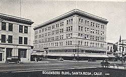
Landmark Number Name Location Image CHB Resolution No./ CC Resolution No./ Notes APNs 1 Miller Ranch (Stone Family Farm) Occidental & Sanford Roads 38°25′31″N 122°49′31″W / 38.425217°N 122.825224°W / 38.425217; -122.825224 (Miller Ranch (Stone Family Farm) ) Stone Family Farm (Laguna Center) chb4/ 130-250-14, 130-250-49, 130-250-50, 060-330-10 2 De Turk Round Barn 819 Donahue Street 38°26′27″N 122°43′31″W / 38.440815°N 122.725211°W / 38.440815; -122.725211 (De Turk Round Barn ) DeTurk Round Barn built in 1891 chb8/ Now in a city park available for rent for weddings and events. 010-144-19 3 Carrillo Adobe Montomery Drive 38°26′55″N 122°41′01″W / 38.448548°N 122.683604°W / 38.448548; -122.683604 (Carrillo Adobe ) Carrillo Adobe built in 1829 chb11/ 013-271-01, 013-274-02 4 Rosenberg Building 306 Mendocino Avenue 38°26′27″N 122°42′51″W / 38.440837°N 122.714155°W / 38.440837; -122.714155 (Rosenberg Building ) chb13/ 009-011-02 5 Bolton House 966 Sonoma Avenue 38°26′24″N 122°42′11″W / 38.439968°N 122.702917°W / 38.439968; -122.702917 (Bolton House ) The Walter and Isabel Bolton House chb15/ 009-211-81 6 Tripp House 1023 Fourth Street 38°26′39″N 122°42′24″W / 38.444032°N 122.706736°W / 38.444032; -122.706736 (Tripp House ) Tripp House built in 1891. chb16/ 009-102-34 7 Luther Burbank Home & Gardens Southeast corner of Santa Rosa and Sonoma Avenues 38°26′10″N 122°42′43″W / 38.436102°N 122.711809°W / 38.436102; -122.711809 (Luther Burbank Home & Gardens ) chb29/ California Historical Landmark #234, and a U.S. National Historic Landmark 009-265-15, 009-265-28 8 312, 316 Chinn Street - Structures Adjacent to Tripp House 1023 Fourth Street 38°26′39″N 122°42′24″W / 38.444032°N 122.706736°W / 38.444032; -122.706736 (312, 316 Chinn Street ) 312 Chinn Street. 316 Chinn Street built prior to 1915. chb41/ cc21023/ 009-102-20, 009-102-34 9 Coddingtown Revolving sign Tower 101 Coddingtown Center 38°27′31″N 122°43′38″W / 38.458578°N 122.727114°W / 38.458578; -122.727114 (Coddingtown Revolving sign Tower ) Coddingtown Revolving Sign installed in 1960 chb44 /
cc21185/ 10 Rosenberg's Department Store 700 Fourth Street 38°26′28″N 122°42′42″W / 38.441194°N 122.711698°W / 38.441194; -122.711698 (Rosenberg's Department Store ) chb47/ cc21775/ Principal tenant in 2019 is Barnes & Noble 009-014-12 11 Santa Rosa Plaque Hampton Woods property, at the confluence of Santa Rosa Creek and Brush Creek Plaque Honoring the Legend of the Naming of Santa Rosa chb49/ 12 Hoag House 6102 Sonoma Highway Hoag House built in 1856. No longer standing. chb61/ cc22426/ Dismantled and stored by City of Santa Rosa. Inadequate protection led to loss of entire fabric of remaining materials. 13 unassigned 14 Sara Building (Sibbald-Donovan Manor) 725 College Avenue 38°26′45″N 122°42′49″W / 38.445736°N 122.713746°W / 38.445736; -122.713746 (Sara Building (Sibbald-Donovan Manor) ) Sara Building (Sibbald-Donovan Manor) chb0062/ cc22610/ 012-023-011 15 Flamingo Resort Sign Tower to include neon-outlined flamingo atop the sign tower 2777 Fourth Street 38°27′03″N 122°41′19″W / 38.450862°N 122.688564°W / 38.450862; -122.688564 (Flamingo Resort Sign Tower ) Flamingo Hotel revolving sign installed in 1955 chb65/ cc22990/ 032-030-002 16 Santa Rosa Rural Cemetery 1900 Franklin Avenue 38°27′20″N 122°42′15″W / 38.455624°N 122.704274°W / 38.455624; -122.704274 (Santa Rosa Rural Cemetery ) The Santa Rosa Rural Cemetery had its first burials in the 1850's. chb72/ cc23251/ 015-281-002, 015-281-004, 015-281-006 17 Church of One Tree 492 Sonoma Avenue 38°26′10″N 122°42′51″W / 38.436004°N 122.714060°W / 38.436004; -122.714060 (Church of One Tree ) chb77/ cc23412/ Moved from Ross and B Streets by the City of Santa Rosa in 1957. Now in Juilliard Park on Sonoma Avenue and available to rent for events. 010-208-022 18 Rose Park House 406 Chinn Street 38°26′41″N 122°42′25″W / 38.444756°N 122.707066°W / 38.444756; -122.707066 (Rose Park House ) 406 Chinn Street - Rose Park House chb79/ cc23476/ 009-102-023 19 Fountaingrove Round Barn 3535 Round Barn Boulevard 38°28′33″N 122°43′39″W / 38.475700°N 122.727450°W / 38.475700; -122.727450 (Fountaingrove Round Barn ) Fountain Grove Round Barn chb98/ cc24329/ burned completely in Tubbs Fire in 2017 173-020-004 20 Alexander House 412 Humboldt Street 38°26′32″N 122°42′47″W / 38.442188°N 122.713142°W / 38.442188; -122.713142 (Alexander House ) Joseph Alexander house -412 Humboldt Street chb1148/ cc25668/ 21 Community Baptist Church 1228 Grand Avenue 38°25′37″N 122°42′24″W / 38.426882°N 122.706669°W / 38.426882; -122.706669 (Community Baptist Church ) Community Baptist Church - 1228 Grand Avenue chb216/ cc3794/ File No. STU05-014 22 Dutton Avenue Queen Anne 895 Dutton Avenue 38°25′38″N 122°43′31″W / 38.427237°N 122.725169°W / 38.427237; -122.725169 (Dutton Avenue Queen Anne ) Queen Anne style Cottage - 895 Dutton Avenue chb244/ 125-271-005