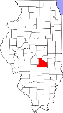
Shelby County, Illinois

Last updated

Shelby County
Shelby County Courthouse in Illinois.jpg
Map of Illinois highlighting Shelby County.svg
Location within the U.S. state of Illinois
Illinois in United States.svg
Illinois's location within the U.S.
Coordinates: 39°23′N88°49′W / 39.39°N 88.81°W / 39.39; -88.81
CountryFlag of the United States.svg United States
StateFlag of Illinois.svg  Illinois
Founded1827
Named for Isaac Shelby
Seat Shelbyville
Largest cityShelbyville
Area
  Total
768 sq mi (1,990 km2)
  Land759 sq mi (1,970 km2)
  Water9.5 sq mi (25 km2)  1.2%
Population
 (2020)
  Total
20,990
  Estimate 
(2023)
20,568 Decrease2.svg
  Density27/sq mi (11/km2)
Time zone UTC−6 (Central)
  Summer (DST) UTC−5 (CDT)
Congressional district 15th
Website www.shelbycounty-il.com

Shelby County is a county located in the U.S. state of Illinois. According to the 2020 census, it had a population of 20,990. [1] Its county seat is Shelbyville. [2]

Contents

History

Shelby County was established in 1827 out of Fayette County. It was named in honor of Isaac Shelby, governor of Kentucky and participant in the American Revolutionary War.

Geography

According to the U.S. Census Bureau, the county has a total area of 768 square miles (1,990 km2), of which 759 square miles (1,970 km2) is land and 9.5 square miles (25 km2) (1.2%) is water. [4]

Climate and weather

Shelbyville, Illinois
Climate chart (explanation)
J
F
M
A
M
J
J
A
S
O
N
D
 
 
2
 
 
34
19
 
 
1.9
 
 
41
24
 
 
3.3
 
 
52
33
 
 
3.7
 
 
65
43
 
 
4
 
 
75
53
 
 
4.1
 
 
83
62
 
 
4
 
 
87
66
 
 
3.3
 
 
85
63
 
 
3.1
 
 
80
56
 
 
3.1
 
 
68
45
 
 
3.9
 
 
52
35
 
 
3
 
 
39
24
Average max. and min. temperatures in °F
Precipitation totals in inches
Source: The Weather Channel [5]
Metric conversion
J
F
M
A
M
J
J
A
S
O
N
D
 
 
51
 
 
1
−7
 
 
48
 
 
5
−4
 
 
84
 
 
11
1
 
 
94
 
 
18
6
 
 
101
 
 
24
12
 
 
103
 
 
28
17
 
 
102
 
 
31
19
 
 
83
 
 
29
17
 
 
77
 
 
27
13
 
 
78
 
 
20
7
 
 
98
 
 
11
2
 
 
76
 
 
4
−4
Average max. and min. temperatures in °C
Precipitation totals in mm

In recent years, average temperatures in the county seat of Shelbyville have ranged from a low of 19 °F (−7 °C) in January to a high of 87 °F (31 °C) in July, although a record low of −26 °F (−32 °C) was recorded in January 1915 and a record high of 111 °F (44 °C) was recorded in July 1936. Average monthly precipitation ranged from 1.89 inches (48 mm) in February to 4.05 inches (103 mm) in June. [5]

Major highways

Adjacent counties

Demographics

Historical population
CensusPop.Note
1830 2,972
1840 6,659124.1%
1850 7,80717.2%
1860 14,61387.2%
1870 25,47674.3%
1880 30,27018.8%
1890 31,1913.0%
1900 32,1263.0%
1910 31,693−1.3%
1920 29,601−6.6%
1930 25,471−14.0%
1940 26,2903.2%
1950 24,434−7.1%
1960 23,404−4.2%
1970 22,589−3.5%
1980 23,9235.9%
1990 22,261−6.9%
2000 22,8932.8%
2010 22,363−2.3%
2020 20,990−6.1%
2023 (est.)20,568 [6] −2.0%
U.S. Decennial Census [7]
1790-1960 [8] 1900-1990 [9]
1990-2000 [10] 2010-2013 [1]

As of the 2010 United States census, there were 22,363 people, 9,216 households, and 6,376 families living in the county. [11] The population density was 29.5 inhabitants per square mile (11.4/km2). There were 10,396 housing units at an average density of 13.7 per square mile (5.3/km2). [4] The racial makeup of the county was 98.6% white, 0.3% Asian, 0.2% American Indian, 0.2% black or African American, 0.2% from other races, and 0.6% from two or more races. Those of Hispanic or Latino origin made up 0.8% of the population. [11] In terms of ancestry, 25.5% were German, 9.9% were English, 9.8% were American, and 8.8% were Irish. [12]

Of the 9,216 households, 29.2% had children under the age of 18 living with them, 57.1% were married couples living together, 8.0% had a female householder with no husband present, 30.8% were non-families, and 27.1% of all households were made up of individuals. The average household size was 2.40 and the average family size was 2.90. The median age was 43.5 years. [11]

The median income for a household in the county was $44,627 and the median income for a family was $55,655. Males had a median income of $40,119 versus $27,860 for females. The per capita income for the county was $21,891. About 7.8% of families and 11.3% of the population were below the poverty line, including 16.7% of those under age 18 and 8.1% of those age 65 or over. [13]

Census-designated place

The Census Bureau has defined one census-designated place (CDP) in Shelby County.

Government

Townships

Shelby County is divided into these townships:

Communities

Cities

Town

Villages

Other unincorporated communities

Politics

United States presidential election results for Shelby County, Illinois [14]
Year Republican Democratic Third party(ies)
No.%No.%No.%
2024 9,26779.41%2,24019.19%1631.40%
2020 9,42677.80%2,50420.67%1851.53%
2016 8,22974.48%2,28820.71%5324.81%
2012 6,84365.55%3,34232.01%2542.43%
2008 6,39658.67%4,24538.94%2612.39%
2004 6,75363.85%3,74435.40%800.76%
2000 5,85157.57%4,01839.54%2942.89%
1996 4,21543.06%4,24943.41%1,32413.53%
1992 3,63132.49%5,10145.65%2,44321.86%
1988 5,37053.28%4,65046.14%580.58%
1984 6,37259.38%4,31740.23%410.38%
1980 6,44159.12%3,98836.61%4654.27%
1976 5,23445.54%6,17253.70%870.76%
1972 7,21762.08%4,38937.75%200.17%
1968 5,48749.27%4,52840.66%1,12210.07%
1964 4,28137.66%7,08862.34%00.00%
1960 6,87254.53%5,72045.39%110.09%
1956 7,07556.94%5,33742.95%130.10%
1952 7,18957.65%5,26842.25%120.10%
1948 5,28247.89%5,58950.68%1581.43%
1944 6,20150.65%5,91948.35%1231.00%
1940 7,25047.71%7,70450.69%2431.60%
1936 5,79540.81%8,18657.64%2201.55%
1932 4,65735.91%8,09362.40%2191.69%
1928 7,21462.58%4,07135.31%2432.11%
1924 5,60548.13%5,26545.21%7766.66%
1920 6,35153.93%5,11343.42%3122.65%
1916 5,91142.61%7,51554.18%4453.21%
1912 1,43120.77%3,46750.33%1,99128.90%
1908 3,31242.30%4,06551.92%4535.79%
1904 3,22046.53%2,96242.80%73810.66%
1900 3,36541.38%4,51455.52%2523.10%
1896 3,07138.75%4,70959.42%1451.83%
1892 2,30432.45%3,52349.62%1,27317.93%

See also

Related Research Articles

<span class="mw-page-title-main">Shelby County, Kentucky</span> County in Kentucky, United States

Shelby County is a county located in the U.S. state of Kentucky. As of the 2020 census, the population was 48,065. Its county seat is Shelbyville. The county was established in 1792 and named for Isaac Shelby, the first Governor of Kentucky. Shelby County is part of the Louisville/Jefferson County, KY–IN Metropolitan Statistical Area. Shelby County's motto is "Good Land, Good Living, Good People".

<span class="mw-page-title-main">Shelby County, Missouri</span> County in Missouri, United States

Shelby County is a county located in the northeastern portion of the U.S. state of Missouri. As of the 2020 census, the population was 6,103. Its county seat is Shelbyville. The county was established on January 2, 1835, and named for Governor Isaac Shelby of Kentucky.

<span class="mw-page-title-main">Shelby County, Indiana</span> County in Indiana, United States

Shelby County is a county in the U.S. state of Indiana. As of the 2020 United States Census, the population was 45,055. The county seat is Shelbyville.

<span class="mw-page-title-main">Moultrie County, Illinois</span> County in Illinois, United States

Moultrie County is a county in the U.S. state of Illinois. According to the 2020 United States Census, its population was 14,526. Its county seat is Sullivan. The name is pronounced as in "mole tree", unlike the pronunciation of its namesake, the South Carolinian Revolutionary War hero William Moultrie.

<span class="mw-page-title-main">Fayette County, Illinois</span> County in Illinois, United States

Fayette County is a county located in the U.S. state of Illinois. As of the 2020 census, the population was 21,488. Its county seat is Vandalia, the site of the Vandalia State House State Historic Site. Ramsey Lake State Recreation Area is located in the northwestern part of this county.

<span class="mw-page-title-main">Cumberland County, Illinois</span> County in Illinois, United States

Cumberland County is a county located in the U.S. state of Illinois. As of the 2020 census, the population was 10,450. Its county seat is Toledo.

<span class="mw-page-title-main">Christian County, Illinois</span> County in Illinois, United States

Christian County is a county located in the U.S. state of Illinois. As of the 2020 census, the population was 34,032. Its county seat is Taylorville.

<span class="mw-page-title-main">Moweaqua, Illinois</span> Village in Illinois, United States

Moweaqua is a village in Shelby and Christian counties, Illinois, United States. The population was 1,764 at the 2020 census.

<span class="mw-page-title-main">Birds, Illinois</span> Unincorporated community in Illinois, United States

Birds is an unincorporated community in Lawrence County, Illinois, United States. The population was 51 at the 2000 census, at which time it was a village. Birds disincorporated on April 7, 2009.

<span class="mw-page-title-main">Findlay, Illinois</span> Village in Illinois, United States

Findlay is a village in Shelby County, Illinois, United States. The population was 664 at the 2020 census.

<span class="mw-page-title-main">Oconee, Illinois</span> Village in Illinois, United States

Oconee is a village in Shelby County, Illinois, United States. The population was 180 at the 2010 census.

<span class="mw-page-title-main">Shelbyville, Illinois</span> City in Illinois, United States

Shelbyville is a city in and the county seat of Shelby County, Illinois, United States, along the Kaskaskia River. As of the 2020 census, the population was at 4,674. HSHS Good Shepherd Hospital, located in town, is the county's only hospital. Shelbyville is also home to Chautauqua Auditorium.

<span class="mw-page-title-main">Sigel, Illinois</span> Town in Illinois, United States

Sigel is an incorporated town in Shelby County, Illinois, United States. The population was 329 at the 2020 census.

<span class="mw-page-title-main">Shelbyville, Indiana</span> City in Indiana, United States

Shelbyville is a city in Addison Township, Shelby County, in the U.S. state of Indiana and is the county seat. The population was 20,067 as of the 2020 census.

<span class="mw-page-title-main">Amboy, Minnesota</span> City in Minnesota, United States

Amboy is a city in Blue Earth County, Minnesota, United States. The population was 535 at the 2020 census. It is part of the Mankato-North Mankato Metropolitan Statistical Area. The city was founded in 1879. It celebrated its 125th anniversary in September 2004.

Shelby Township is a township in Blue Earth County, Minnesota, United States. The population was 294 as of the 2000 census.

<span class="mw-page-title-main">Shelbyville, Missouri</span> City in Missouri, United States

Shelbyville is a city in Shelby County, Missouri, United States. The population was 518 at the 2020 census. It is the county seat of Shelby County.

<span class="mw-page-title-main">Clarksburg, Tennessee</span> Town in Tennessee, United States

Clarksburg is a town in Carroll County, Tennessee, United States. The population was 393 at the 2010 census. Clarksburg has its own high school.

<span class="mw-page-title-main">Anmoore, West Virginia</span> Town in West Virginia, United States

Anmoore is a town in Harrison County, West Virginia, United States. It is located at the intersection of WV 58 and Interstate 79. The population was 514 at the 2020 census.

<span class="mw-page-title-main">Prairieton Township, Christian County, Illinois</span> Township in Illinois, United States

Prairieton Township is one of seventeen townships in Christian County, Illinois, United States. As of the 2020 census, its population was 425 and it contained 177 housing units.

References

  1. 1 2 "State & County QuickFacts". United States Census Bureau. Retrieved July 8, 2014.
  2. "Find a County". National Association of Counties. Retrieved June 7, 2011.
  3. White, Jesse. Origin and Evolution of Illinois Counties. State of Illinois, March 2010.
  4. 1 2 "Population, Housing Units, Area, and Density: 2010 - County". United States Census Bureau. Archived from the original on February 12, 2020. Retrieved July 12, 2015.
  5. 1 2 "Monthly Averages for Shelbyville, Illinois". The Weather Channel. Retrieved January 27, 2011.
  6. "Annual Estimates of the Resident Population for Counties: April 1, 2020 to July 1, 2023". United States Census Bureau. Retrieved April 2, 2024.
  7. "U.S. Decennial Census". United States Census Bureau. Retrieved July 8, 2014.
  8. "Historical Census Browser". University of Virginia Library. Retrieved July 8, 2014.
  9. "Population of Counties by Decennial Census: 1900 to 1990". United States Census Bureau. Retrieved July 8, 2014.
  10. "Census 2000 PHC-T-4. Ranking Tables for Counties: 1990 and 2000" (PDF). United States Census Bureau. Retrieved July 8, 2014.
  11. 1 2 3 "DP-1 Profile of General Population and Housing Characteristics: 2010 Demographic Profile Data". United States Census Bureau. Archived from the original on February 13, 2020. Retrieved July 12, 2015.
  12. "DP02 SELECTED SOCIAL CHARACTERISTICS IN THE UNITED STATES – 2006-2010 American Community Survey 5-Year Estimates". United States Census Bureau. Archived from the original on February 13, 2020. Retrieved July 12, 2015.
  13. "DP03 SELECTED ECONOMIC CHARACTERISTICS – 2006-2010 American Community Survey 5-Year Estimates". United States Census Bureau. Archived from the original on February 13, 2020. Retrieved July 12, 2015.
  14. Leip, David. "Dave Leip's Atlas of U.S. Presidential Elections". uselectionatlas.org. Retrieved November 12, 2018.

39°23′N88°49′W / 39.39°N 88.81°W / 39.39; -88.81