
Warwick is a rural town and locality in southeast Queensland, Australia, lying 130 kilometres (81 mi) south-west of Brisbane. It is the administrative centre of the Southern Downs Region local government area. The surrounding Darling Downs have fostered a strong agricultural industry for which Warwick, together with the larger city of Toowoomba, serve as convenient service centres. In the 2021 census, the locality of Warwick had a population of 12,294 people.
Killarney is a rural town and locality in the Southern Downs Region, Queensland, Australia. It borders New South Wales. In the 2021 census, the locality of Killarney had a population of 918 people.

Maryvale is a rural town and locality in the Southern Downs Region, Queensland, Australia. In the 2021 census, the locality of Maryvale had a population of 392 people.

Dalveen is a town and a locality in the Southern Downs Region, Queensland, Australia. It borders New South Wales. In the 2021 census, the locality of Dalveen had a population of 369 people.

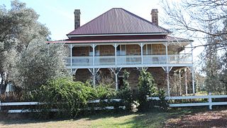
Glengallan is a rural locality in the Southern Downs Region, Queensland, Australia. In the 2021 census, Glengallan had a population of 57 people.
Swan Creek is a rural locality in the Southern Downs Region, Queensland, Australia. In the 2021 census, Swan Creek had a population of 161 people.

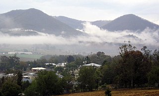
Yangan is a rural town and locality in the Southern Downs Region, Queensland, Australia. In the 2021 census, the locality of Yangan had a population of 404 people.
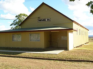
Tannymorel is a rural town and locality in the Southern Downs Region, Queensland, Australia. In the 2021 census, the locality of Tannymorel had a population of 148 people.
Lockyer is a rural locality in the Lockyer Valley Region, Queensland, Australia. In the 2021 census, Lockyer had a population of 89 people.
Owanyilla is a rural town and locality in the Fraser Coast Region, Queensland, Australia. In the 2021 census, the locality of Owanyilla had a population of 245 people.

Danderoo is a rural locality in the Southern Downs Region, Queensland, Australia. In the 2021 census, Danderoo had a population of 40 people.

Emu Vale is a rural town and locality in the Southern Downs Region, Queensland, Australia. In the 2021 census, the locality of Emu Vale had a population of 161 people.

Mount Colliery is a rural locality in the Southern Downs Region, Queensland, Australia. In the 2021 census, Mount Colliery had a population of 117 people.

Goomburra is a rural town and locality in the Southern Downs Region, Queensland, Australia. In the 2021 census, the locality of Goomburra had a population of 256 people.
Rosehill is a rural locality in the Southern Downs Region, Queensland, Australia. In the 2021 census, Rosehill had a population of 134 people.
Womina is a rural locality in the Southern Downs Region, Queensland, Australia. In the 2021 census, Womina had a population of 207 people.

Silverwood is a rural locality in the Southern Downs Region, Queensland, Australia. In the 2021 census, Silverwood had a population of 58 people.
Rosenthal Heights is a mixed-use locality in the Southern Downs Region, Queensland, Australia. In the 2021 census, Rosenthal Heights had a population of 2,664 people.
Wiyarra is a rural locality in the Southern Downs Region, Queensland, Australia. In the 2021 census, Wiyarra had a population of 20 people.
Mount Sturt is a rural locality in the Southern Downs Region, Queensland, Australia. In the 2021 census, Mount Sturt had "no people or a very low population".
