Altman, Colorado

Last updated
Altman, Colorado
Altman, Colorado (53566413365).jpg
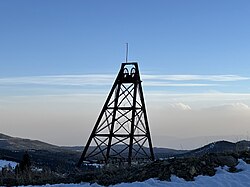
Headframe at road entering Altman, Colorado
Usa edcp location map.svg
Red pog.svg
Altman
Location of Altman, Colorado.
USA Colorado location map.svg
Red pog.svg
Altman
Altman (Colorado)
Coordinates: 38°44′10″N105°08′02″W / 38.7361°N 105.1339°W / 38.7361; -105.1339 [1]
Country United States
State Colorado
County Teller [2]
Government
  Body Teller County [2]
Elevation
[1]
10,630 ft (3,240 m)
Time zone UTC−07:00 (MST)
  Summer (DST) UTC−06:00 (MDT)
GNIS pop ID 203908

Altman is an extinct mining town located in Teller County, Colorado, United States.

Contents

History

The Altman, Colorado, post office operated from January 18, 1894, until May 30, 1911. [3] Much of the town was destroyed by fire on May 24, 1903.

Geography

Altman is located at coordinates 38°44′10″N105°08′02″W / 38.7361°N 105.1339°W / 38.7361; -105.1339 , at an elevation of 10,630 feet (3,240 m).

See also

References

  1. 1 2 "Altman, Colorado". Geographic Names Information System . United States Geological Survey, United States Department of the Interior . Retrieved December 29, 2024.
  2. 1 2 "Colorado Counties". Colorado Department of Local Affairs . Retrieved January 12, 2025.
  3. Bauer, William H.; Ozment, James L.; Willard, John H. (1990). Colorado Post Offices 1859–1989. Golden, Colorado: Colorado Railroad Historical Foundation. ISBN   0-918654-42-4.