Intendancy of Chiloé

Last updated • 5 min readFrom Wikipedia, The Free Encyclopedia
Intendencia de Chiloé
Intendancy of Spanish Empire
1784–1789
Flag of Spain (1785-1873 and 1875-1931).svg
Capital San Carlos de Chiloé
Government
Governor Intendant 
 1784–1789
F. Hurtado del Pino [1]
 1788–1791 (interim)
Col. Francisco Garos
History 
 Established
1784
 Disestablished
1789
Subdivisions
  Type Curates
Preceded by
Succeeded by
Flag of Spain (1785-1873, 1875-1931).svg Governorate of Chiloé
Governorate of Chiloé Flag of Spain (1785-1873, 1875-1931).svg

The Intendancy of Chiloé (Intendencia de Chiloé), was an ephemeral administrative division of the Spanish Empire that existed in Chiloé Archipelago, then part of the Captaincy General of Chile, itself part of the Viceroyalty of Peru, between 1784 and 1789.

Contents

History

With the Bourbon Reforms during the 18th century, intendiancies were created, governed by a governor. These were divided into partidos governed by subdelegates. Chiloé was the first intendancy established in the Kingdom of Chile when King Charles III designated the military engineer and infantry lieutenant colonel Francisco Hurtado del Pino as his governor intendant by royal title on May 19, 1784. On May 20, May 19 Hurtado received particular instructions in another royal title where Chiloé was mentioned as "a possession as interesting to his crown as it was estimable and coveted by his enemies," and he was charged with dedicating "all his efforts and the greatest efforts to defend and preserve it." [2]

Hurtado arrived in San Carlos de Chiloé on December 17, 1786 together with Francisco Machado, whom Viceroy Teodoro de Croix commissioned to help Hurtado prepare a general charter of Chiloé as ordered by royal order. [3]

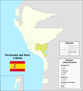
Complying with the eighth of the royal instructions received, in 1785 the governor-intendant Hurtado had the General Register of the Province of Chiloé drawn up, in which he compiled census information on the population subject to his obedience in the intendant's office. The censused territory was divided into three curates, [4] which in turn were divided into districts, and into chapels (capillas) or towns: [5] [6]

The parties mentioned in the registry correspond to rural pagos according to the terminology used before the application of the intendant's ordinance, since due to the prevailing poverty the Chiloé intendant's office did not have partisan subdelegates at the head of the parties or subdelegations such as the created in other intendancies. [8]

For a better understanding of his results, Hurtado commissioned the creation of a map of the province indicating its areas of effective settlement. The creation of this map is attributed to the Spanish pilot José de Moraleda y Montero, who was in the area during the census. [9] Moraleda, after the census, made two circumnavigation trips around Chiloé Island between 1787 and 1788, describing its coasts, in addition to the coasts of Carelmapu and Calbuco, preparing the map. [10] In the annex to this map the limits of the intendant's office are indicated, which, being known by the governor intendant, having been studied by royal order prior to his trip to the island, the reports and background of the Chiloé government are not explicitly indicated in the royal title of May 19, 1784 that created it. [11]

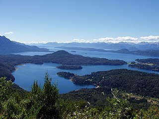
Most of this territory was not under effective control of the Spanish Empire, partly because it was still in the power of the indigenous peoples of the area and partly because it was completely uninhabited. Outside the Chiloé islands, there were Spanish settlements in the Calbuco archipelago and in Carelmapu. In a royal order of May 31, 1784, the king ordered Hurtado and the governor of Valdivia to each begin the works of the Camino Real between Carelmapu and Valdivia, passing through the ruins of Osorno, with the Bueno River being the recognized limit. by both jurisdictions. Although both rulers did not agree on the route of the road, in March 1787 Hurtado sent an expedition that reached Llanquihue Lake and in April returned to Maullín. Shortly afterward he sent another expedition in search of the ruins of Osorno. [12] He also commissioned works to rebuild the forts of Agüi, Calbuco, Carelmapu and Castro.

Due to his training in engineering, Hurtado was commissioned to prepare reports on the economic and military situation of the archipelago, where in the first stage he expressed himself in favor of the union of Chiloé with Peru over his old link with Chile. [4] However, in a second stage he began to perceive that dependence on the viceroyalty hindered his administration, and that the best way to govern Chiloé was to convert it into a general captaincy that dealt directly with the Council of the Indies in Spain. [4] These differences with the viceroy Teodoro de Croix ended up causing his dismissal in 1789, as well as the abolition of the intendancy, which from then on would once again be converted into a military governorate, with governors trusted by the viceroy. [4] Croix in his relationship to his successor referred to the dispute: [13]

[...] this Royal Court received a letter from that Intendant in which he included a document for the Superior Board. In the letter he says, among other things, that I and my Advisor invaded it, that we intercepted the steps of its jurisdiction, that the Island of Chiloé is not subject to this Captaincy General nor to that of Chile, that according to its title, and instruction that was given, Intendant's Ordinances and subsequent orders that have been addressed to him, that Island is an indifferent overseas Province, which in its Government depends only on His Majesty and the reserved path [...] Intendant Hurtado is in this capital destined to be sent to Spain accompanied by his cause, by Royal Order of May 10, 1789, for the insubordination and excesses committed in his Government and Municipality of the Island of Chiloé [...]

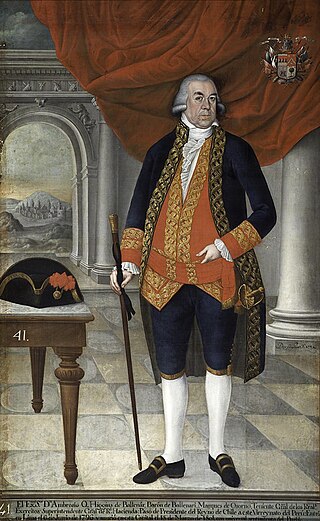
Viceroy Croix temporarily appointed Colonel Francisco Garos as governor-intendant to replace Hurtado, whom he ordered to travel to Lima to defend himself from his prosecution. The Balbanera frigate that was transporting Garos was shipwrecked in the shoals of the port of San Carlos on December 22, 1788, but Garos managed to save himself and Hurtado handed over the government to him. Garos remained until the end of 1791 when Pedro Cañaveral y Ponce arrived, appointed by the king on June 24, 1789 as political and military governor without the rank of intendant. Chiloé continued its dependence on the Viceroyalty of Peru until its disappearance in 1824 and as an isolated military governorate until its annexation to Chile in 1826. [14]

See also

Related Research Articles

<span class="mw-page-title-main">Viceroyalty of Peru</span> South American administrative district of Spain (1542–1824)

The Viceroyalty of Peru, officially known as the Kingdom of Peru, was a Spanish imperial provincial administrative district, created in 1542, that originally contained modern-day Peru and most of the Spanish Empire in South America, governed from the capital of Lima. Along with the Viceroyalty of New Spain, Peru was one of two Spanish viceroyalties in the Americas from the sixteenth to the eighteenth centuries.

<span class="mw-page-title-main">Agustín de Jáuregui</span>

Agustín de Jáuregui y Aldecoa was a Spanish politician and soldier who served as governor of Chile (1772–80) and viceroy of Peru (1780–84).

<span class="mw-page-title-main">Teodoro de Croix</span>

Teodoro de Croix was a Spanish soldier and colonial official in New Spain and Peru. From April 6, 1784 to March 25, 1790 he was viceroy of Peru.

<span class="mw-page-title-main">Provincias Internas</span> Administrative district of the Spanish Empire

The Provincias Internas, also known as the Comandancia y Capitanía General de las Provincias Internas, was an administrative district of the Spanish Empire created in 1776 to provide more autonomy for the frontier provinces of the Viceroyalty of New Spain, present-day northern Mexico and the Southwestern United States. The goal of its creation was to establish a unified government in political, military and fiscal affairs. Nevertheless, the Commandancy General experienced significant changes in its administration because of experimentation to find the best government for the frontier region as well as bureaucratic in-fighting. Its creation was part of the Bourbon Reforms and was part of an effort to invigorate economic and population growth in the region to stave off encroachment on the region by foreign powers. During its existence, the Commandancy General encompassed the provinces of Nueva Navarre, Nueva Vizcaya, Las Californias, Nuevo México, Nuevo Santander, Nuevo Reyno de León, Coahuila and Texas.

Alonso de Figueroa y Cordova was a Spanish soldier who, in the days of the reign of Philip IV of Spain, temporarily carried out the position of Captain General and Royal Governor of Chile, besides president of its Real Audiencia of Chile. His government lasted for 13 months, between April 1649 and May 1650. He was the grandfather of the Chilean historian Pedro de Cordoba y Figueroa.

<span class="mw-page-title-main">Ambrosio de Benavides</span> Spanish colonial governor

Ambrosio de Benavides Medina Liñán y Torres was a Spanish colonial administrator who served as Royal Governor of Puerto Rico, Royal Governor of Charcas and Royal Governor of Chile.

Francisco Hernández Ortiz-Pizarro (1555–1613) was the founder of Fort Calbuco. He was born in Villacastín, Spain. Having survived the Destruction of the Seven Cities he led a group of loyal Huilliches to the area of Chacao Channel where Fort Calbuco was established.

The southern coast of Chile presents a large number of fjords and fjord-like channels from the latitudes of Cape Horn to Reloncaví Estuary. Some fjords and channels are important navigable channels providing access to ports like Punta Arenas, Puerto Chacabuco and Puerto Natales.

<span class="mw-page-title-main">Ambrosio O'Higgins, 1st Marquess of Osorno</span> Irish-Spanish colonial administrator

Ambrosio Bernardo O'Higgins y O'Higgins, 1st Marquess of Osorno born Ambrose Bernard O'Higgins, was an Irish-Spanish colonial administrator and a member of the O'Higgins family.

Francisco Hurtado del Pino was a Spanish colonial officer who served as the first and only Intendant of Chiloé between 1784 and 1789. In 1786 Viceroy of Peru Teodoro de Croix sent Hurtado del Pino navy officer José de Moraleda y Montero to aid him making accurate maps of the archipelago. Eventually Moraleda would stay in Chiloé until 1796 long after the intendantship of hurtado del Pino. After Hurtado's term ended the Intendancy of Chiloé was abolished and lieutenant colonel Francisco Garos took charge of the affairs in Chiloé Archipelago.

<span class="mw-page-title-main">Dutch expedition to Valdivia</span> 1643 failed expedition to Chile

The Dutch expedition to Valdivia was a naval expedition, commanded by Hendrik Brouwer, sent by the Dutch Republic in 1643 to establish a base of operations and a trading post on the southern coast of Chile. With Spain and the Dutch Republic at war, the Dutch wished to take over the ruins of the abandoned Spanish city of Valdivia. The expedition sacked the Spanish settlements of Carelmapu and Castro in the Chiloé Archipelago before sailing to Valdivia, having the initial support of the local natives. The Dutch arrived in Valdivia on 24 August 1643 and named the colony Brouwershaven after Brouwer, who had died several weeks earlier. The short-lived colony was abandoned on 28 October 1643. Nevertheless, the occupation caused great alarm among Spanish authorities. The Spanish resettled Valdivia and began the construction of an extensive network of fortifications in 1645 to prevent a similar intrusion. Although contemporaries considered the possibility of a new incursion, the expedition was the last one undertaken by the Dutch on the west coast of the Americas.

<span class="mw-page-title-main">Governorate of Chiloé</span> Political and military subdivision of the Spanish Empire

The Governorate of Chiloé was political and military subdivision of the Spanish Empire that existed, with a 1784–1789 interregnum,from 1567 to 1848. The Governorate of Chiloé depended on the Captaincy General of Chile until the late 18th century when it was made dependent directly on the Viceroyalty of Peru. The administrative change was done simultaneously as the capital of the archipelago was moved from Castro to Ancud in 1768. The last Royal Governor of Chiloé, Antonio de Quintanilla, depended directly on the central government in Madrid.

José Marín de Velasco was a Governor of Chiloé in the early 18th century. He was named Royal Governor of Chiloé by the King of Spain in 1708 by doing a monetary contribution—or in other words de facto purchasing the office.

<span class="mw-page-title-main">Mission of Nahuel Huapi</span> Religious mission in the kingdom of Chile, currently Argentina

The Mission of Nahuel Huapi was an intermittent Jesuit mission that existed in colonial times on the shores of Nahuel Huapi Lake, northern Patagonia. The exact locations of the missions are not known but it has been suggested, based on a Christian grave finding, that the mission of the early 18th century was located in Huemul Peninsula.

José Manuel de Moraleda y Montero was a Spanish naval officer and cartographer known for his explorations of Chiloé and the archipelagos of Patagonia in the late 18th century. During his lifetime he gained a reputation of sorcerer in Chiloé and is remembered so in local folklore. The first-order waterway of Moraleda Channel is named after him.

The Antonio de Vea expedition of 1675–1676 was a Spanish naval expedition to the fjords and channels of Patagonia aimed to find whether rival colonial powers—specifically, the English—were active in the region. While this was not the first Spanish expedition to the region, it was the largest up to then, involving 256 men, one ocean-going ship, two long boats and nine dalcas. The expedition dispelled suspicion about English bases in Patagonia. Spanish authorities' knowledge of western Patagonia was greatly improved by the expedition, yet Spanish interest in the area waned thereafter until the 1740s.

The Huilliche uprising of 1792 was an indigenous uprising against the Spanish penetration into Futahuillimapu, territory in southern Chile that had been de facto free of Spanish rule since 1602. The first part of the conflict was a series of Huilliche attacks on Spanish settlers and the mission in the frontier next to Bueno River. Following this a militia in charge of Tomás de Figueroa departed from Valdivia ravaging Huilliche territory in a quest to subdue anti-Spanish elements in Futahuillimapu.

<span class="mw-page-title-main">Intendancy of Lima</span> Intendancy of the Spanish Empire

The Intendancy of Lima, also known informally as Lima Province, was one of the territorial divisions of the Viceroyalty of Peru. The territory was ruled from the capital city of Lima. It was created in 1784 and lasted until 12 February 1821 when General Jose de San Martin created the Department of the Coast through the Reglamento Provisional to replace it in the new Republic of Peru.

<span class="mw-page-title-main">Intendancy of Huancavelica</span> Intendancy of the Spanish Empire

The Intendancy of Huancavelica, also known informally as Huancavelica Province, was one of the territorial divisions of the Viceroyalty of Peru. The territory was ruled from Huancavelica. It existed from 1784 to 1822.

<span class="mw-page-title-main">Intendancy of Puno</span> Intendancy of the Spanish Empire

The Intendancy of Puno, also known informally as Puno Province, was one of the territorial divisions of the Spanish Empire in the Altiplano region, initially as part of the Viceroyalty of the Río de la Plata and later of the Viceroyalty of Peru. The territory was ruled from San Carlos de Puno.

References

  1. Hanisch 1982, p. 150
  2. "Boletín de la Academia Chilena de la Historia". Academia Chilena de la Historia . 1988.
  3. Menéndez, Francisco (1896). Libro de los diarios de fray Francisco Menéndez (in Spanish). Vol. 1–2. C. F. Niemeyer. p. 98.
  4. 1 2 3 4 Aravena, Gonzalo (2017). Chiloé 1826: El proceso de incorporación de Chiloé a la República de Chile, 1813-1831 (in Spanish). Ediciones 1826. pp. 58–65. ISBN   9789563629958.
  5. O'Donnell y Duque de Estrada, Hugo (1990). El viaje a Chiloé de José de Moraleda (1787-1790) (in Spanish). Editorial Naval. p. 32. ISBN   8473410548.
  6. Censo de 1813 (PDF) (in Spanish). Santiago: Imprenta Chile. 1953. Archived from the original (PDF) on 2017-04-28.
  7. 1 2 3 Archivo Nacional de Chile, Fondo Antiguo, Vol. 26.
  8. "La Intendencia de Chiloé". Chiloé 1826.
  9. Guarda; Moreno (2009). Monumenta Cartographica Chiloensia (in Spanish). p. 168.
  10. O'Donnell y Duque de Estrada, Hugo (1990). El viaje a Chiloé de José de Moraleda (1787-1790) (in Spanish). Madrid: Editorial Naval.
  11. Francisco Hurtado. Padrón General de la Provincia de Chiloé. Quoted in Donoso, o.c., 325.
  12. Historia fisica y politica de Chile segun documentos adquiridos en esta republica durante doce años de residencia en ella y publicada bajo los auspicios del supremo gobierno (in Spanish). Vol. 2. 1844. p. 283.
  13. Zerdán de Landa y Simón Pontero, Ambrosio María. Fuentes, Manuel Atanascio (ed.). Memorias de los vireyes que han gobernado el Perú: durante el tiempo del coloniaje español (in Spanish). Vol. 5. p. 198.
  14. Lacoste, Pablo (2002). "La Guerra de los Mapas Entre Argentina y Chile: Una Mirada Desde Chile". Historia. 35: 211–249. doi: 10.4067/S0717-71942002003500009 via SciELO.

Bibliography