List of strong typhoons

Last updated

Typhoon Morakot approaching Taiwan in August 2009 Typhoon Morakot Aug 7 2009.jpg
Typhoon Morakot approaching Taiwan in August 2009

A strong typhoon is the lowest category used by the Japan Meteorological Agency (JMA) to classify tropical cyclones that has reached typhoon intensity in the Northwest Pacific basin. The basin is limited to the north of the equator between the 100th meridian east and the 180th meridian. The category of a strong typhoon is defined as a tropical cyclone that has 10-minute sustained wind speeds between 64 and 84 knots (118–116 km/h; 74–97 mph).

Contents

Background

RSMC Tokyo's Tropical Cyclone Intensity Scale
CategorySustained winds
Violent typhoon≥105  knots
≥194 km/h
Very strong typhoon85–104  knots
157–193 km/h
Typhoon64–84  knots
118–156 km/h
Severe tropical storm48–63  knots
89–117 km/h
Tropical storm34–47  knots
62–88 km/h
Tropical depression≤33  knots
≤61 km/h

The Northwest Pacific basin covers a vast area in the Pacific Ocean, located north of the equator, between 100°E and 180°E. [1] Several weather agencies monitor this basin, however it is officially monitored by the Japan Meteorological Agency (JMA, RSMC Tokyo), who is responsible for forecasting, naming and issuing warnings for tropical cyclones. [1] Unofficially, the Joint Typhoon Warning Center also monitors the basin, however these warnings measures 1-minute sustained wind speeds, comparing their scale to the Saffir–Simpson scale. [2] The JMA uses a simpler scale on classifying tropical cyclones adapted by the ESCAP/WMO Typhoon Committee measuring 10-minute sustained wind speeds, ranging from a tropical depression, tropical storm, severe tropical storm and typhoon. [3] Furthermore, the JMA divides the typhoon category into three sub-categories for domestic purposes – a strong typhoon, very strong typhoon and violent typhoon. [3]

This article covers a list of systems developing in the Northwest Pacific basin that were classified by the JMA's category of a strong typhoon. The category of a strong typhoon ranges with 10-minute sustained winds of between 64 and 84 knots (118–116 km/h; 74–97 mph). [3]

Systems

Key

1990s

NameSystem datesDuration
(hours)
Sustained
wind speeds
PressureAreas affectedDamage
(USD)
DeathsRefs
Marian May 17 – 18, 199036130 km/h (80 mph)965 hPa (28.50 inHg) Philippines, Taiwan NoneNone
Ofelia June 22 – 23, 199012120 km/h (75 mph)970 hPa (28.64 inHg) Philippines, Taiwan, East China, Korean Peninsula Unknown64
Percy June 23 – 29, 1990132150 km/h (90 mph)950 hPa (28.05 inHg) Caroline Islands, Philippines, Taiwan, China Unknown9
Vernon July 31 – August 4, 199072140 km/h (85 mph)955 hPa (28.20 inHg)NoneNoneNone
Yancy August 17 – 19, 199054150 km/h (90 mph)950 hPa (28.05 inHg) Mariana Islands, Taiwan, China Unknown236
Zola August 20 – 22, 199048140 km/h (85 mph)960 hPa (28.35 inHg) Japan None3
Becky August 27 – 29, 199042130 km/h (80 mph)965 hPa (28.50 inHg) Philippines, Taiwan NoneNone
Abe August 28 – 31, 199060140 km/h (85 mph)955 hPa (28.20 inHg) Ryukyu Islands, Japan, Taiwan, East China, South Korea 184
Dot September 6 – 7, 199042140 km/h (85 mph)960 hPa (28.35 inHg) Philippines, South China, Taiwan Unknown7
Ed September 15 – 18, 199072130 km/h (80 mph)965 hPa (28.50 inHg) Philippines, Vietnam, South China Unknown7
Gene September 25 – 29, 199096150 km/h (90 mph)950 hPa (28.05 inHg) Japan Unknown4
Hattie October 3 – 7, 1990102150 km/h (90 mph)950 hPa (28.05 inHg) Japan Unknown3
Kyle October 20 – 22, 199054140 km/h (85 mph)955 hPa (28.20 inHg)NoneNoneNone
Yunya June 13 – 14, 199130150 km/h (90 mph)950 hPa (28.05 inHg) Philippines Unknown7
Zeke July 12, 199118120 km/h (75 mph)970 hPa (28.64 inHg) Philippines, South China Unknown23
Caitlin July 25 – 29, 199196150 km/h (90 mph)940 hPa (27.76 inHg) Philippines, Taiwan, Japan, South Korea 19
Ellie August 13 – 15, 199145130 km/h (80 mph)960 hPa (28.35 inHg) Ryukyu Islands, Taiwan, East China NoneNone
Fred August 14 – 16, 199154150 km/h (90 mph)960 hPa (28.35 inHg) South China, Indochina Unknown38
Kinna September 12 – 13, 199133150 km/h (90 mph)955 hPa (28.20 inHg) Japan, Korean Peninsula Unknown9
Nat September 21 – October 1, 199169†150 km/h (90 mph)950 hPa (28.05 inHg) Philippines, Taiwan, China UnknownUnknown
Chuck June 27 – 28, 199230130 km/h (80 mph)965 hPa (28.50 inHg) Philippines, South China, Vietnam 7
Eli July 11, 19926130 km/h (80 mph)965 hPa (28.50 inHg) Philippines, South China, Vietnam 1
Brian October 22 – 24, 199260150 km/h (90 mph)950 hPa (28.05 inHg) Caroline Islands NoneNone
Tasha August 20 – 21, 199318120 km/h (75 mph)975 hPa (28.79 inHg) Philippines, South China NoneNone
Vernon August 25 – 27, 199351130 km/h (80 mph)960 hPa (28.35 inHg) Japan Unknown2
Dot September 25 – 26, 199318130 km/h (80 mph)965 hPa (28.50 inHg) Philippines, South China UnknownNone
Flo October 4, 199312120 km/h (75 mph)970 hPa (28.79 inHg) Philippines, Ryukyu Islands Unknown10
Kyle November 22 – 23, 199324130 km/h (80 mph)960 hPa (28.35 inHg) Philippine, Vietnam, Cambodia Unknown70
Lola December 4 – 8, 199360†150 km/h (90 mph)955 hPa (28.20 inHg) Philippines, Indochina Unknown308
Manny December 9 – 10, 199330140 km/h (85 mph)955 hPa (28.20 inHg) Philippines, Vietnam, Thailand Unknown230
Page May 15 – 16, 199430130 km/h (80 mph)965 hPa (28.50 inHg) Caroline Islands NoneNone
Ellie August 12 – 14, 199448150 km/h (90 mph)965 hPa (28.50 inHg) Japan, East China NoneNone
Gladys August 31 – September 1, 199424150 km/h (90 mph)955 hPa (28.20 inHg) Ryukyu Islands, Taiwan, East China 6
Ivy August 31 – September 1, 199430140 km/h (85 mph)960 hPa (28.35 inHg)NoneNoneNone
Kinna September 9 – 11, 199448140 km/h (85 mph)960 hPa (28.35 inHg)NoneNoneNone
Pat September 23 – 24, 199442130 km/h (80 mph)965 hPa (28.35 inHg)NoneNoneNone
Teresa October 19 – 24, 199484150 km/h (90 mph)955 hPa (28.20 inHg) Mariana Islands, Philippines, Vietnam, Cambodia 16
Verne October 20 – 27, 1994174150 km/h (90 mph)950 hPa (28.05 inHg)NoneNoneNone
Faye July 22 – 23, 199533140 km/h (85 mph)950 hPa (28.05 inHg) Ryukyu Islands, Korean Peninsula Unknown16
Mark September 1, 199518120 km/h (75 mph)985 hPa (29.09 inHg)NoneNoneNone
Polly September 18 – 21, 199566140 km/h (85 mph)960 hPa (28.35 inHg) Philippines, Taiwan, Japan UnknownNone
Brian October 22 – 24, 199560150 km/h (90 mph)950 hPa (28.05 inHg) Caroline Islands NoneNone
Dan July 8 – 9, 199630120 km/h (75 mph)970 hPa (28.64 inHg) Japan NoneNone
Gloria July 24 – 26, 199654120 km/h (75 mph)965 hPa (28.50 inHg) Philippines, Taiwan, South China 23
Kirk August 10 – 14, 1996102140 km/h (85 mph)955 hPa (28.20 inHg) Ryukyu Islands, Japan None2
Niki August 21 – 22, 199630120 km/h (75 mph)970 hPa (28.64 inHg) Philippines, South China, Vietnam Unknown
Orson August 25 – 28, 199678140 km/h (85 mph)955 hPa (28.20 inHg)NoneNoneNone
Tom September 15 – 18, 199672130 km/h (80 mph)965 hPa (28.50 inHg)NoneNoneNone
Zane September 26 – October 1, 1996132150 km/h (90 mph)950 hPa (28.05 inHg) Micronesia NoneNone
Carlo October 24, 199624130 km/h (80 mph)965 hPa (28.50 inHg) Mariana Islands NoneNone
Marie May 31, 199718120 km/h (75 mph)965 hPa (28.50 inHg)NoneNoneNone
Tina August 4 – 8, 1997108140 km/h (85 mph)955 hPa (28.20 inHg) Ryukyu Islands, South Korea NoneNone
Amber August 23 – 28, 1997132150 km/h (90 mph)950 hPa (28.05 inHg) Philippines, Taiwan, China Unknown
Otto August 4, 19986120 km/h (75 mph)970 hPa (28.64 inHg) Philippines, Taiwan, East China 5
Rex August 26 – September 3, 1998210140 km/h (85 mph)955 hPa (28.20 inHg) Japan None25
Todd September 17 – 18, 199830140 km/h (85 mph)955 hPa (28.20 inHg) Ryukyu Islands, East China 7
Vicki September 21 – 22, 199824140 km/h (85 mph)960 hPa (28.35 inHg) Philippines, Japan 108
Yanni September 29, 19986120 km/h (75 mph)965 hPa (28.50 inHg) Taiwan, Ryukyu Islands, South Korea Unknown50
Faith December 10 – 11, 199830120 km/h (75 mph)970 hPa (28.64 inHg) Philippines, Vietnam, Laos 48
Leo April 30, 199924120 km/h (75 mph)970 hPa (28.64 inHg) South China NoneNone
Maggie June 4 – 5, 199948140 km/h (85 mph)955 hPa (28.20 inHg) Philippines, Taiwan, South China 9
Olga August 1, 19996120 km/h (75 mph)970 hPa (28.64 inHg) Ryukyu Islands, Korean Peninsula 106
Dan October 4 – 8, 1999102†130 km/h (80 mph)955 hPa (28.20 inHg) Philippines, Taiwan, China, South Korea 44

2000s

NameSystem datesDuration
(hours)
Sustained
wind speeds
PressureAreas affectedDamage
(USD)
DeathsRefs
Kai-tak July 6 – 8, 200048140 km/h (85 mph)960 hPa (28.35 inHg) Philippines, Taiwan, East China, Korean Peninsula Unknown16
Ewiniar August 15 – 16, 200018120 km/h (75 mph)975 hPa (28.79 inHg)NoneNoneNone
Prapiroon August 30 – 31, 200030130 km/h (89 mph)950 hPa (28.05 inHg) Ryukyu Islands, Taiwan, East China, Korean Peninsula 75
Wukong September 7 – 9, 200036140 km/h (85 mph)955 hPa (28.20 inHg) South China, Vietnam, Laos NoneNone
Yagi October 24 – 25, 200024130 km/h (80 mph)965 hPa (28.50 inHg) Ryukyu Islands, Taiwan NoneNone
Xangsane October 29 – 31, 200048140 km/h (85 mph)960 hPa (28.35 inHg) Philippines, Taiwan, Japan Unknown16
Soulik January 3 – 4, 200124150 km/h (90 mph)950 hPa (28.05 inHg)NoneNoneNone
Chebi June 22 – 23, 200118120 km/h (75 mph)965 hPa (28.50 inHg) Philippines, Taiwan, China 108
Kong-rey July 25 – 28, 200160130 km/h (80 mph)955 hPa (28.20& inHg)NoneNoneNone
Toraji July 27 – 29, 200148120 km/h (75 mph)965 hPa (28.50 inHg) Philippines, Taiwan, East China 200
Man-yi August 4 – 7, 200196150 km/h (90 mph)955 hPa (28.20 inHg) Mariana Islands None
Pabuk August 17 – 21, 2001105130 km/h (80 mph)960 hPa (28.35 inHg) Mariana Islands, Japan 6
Nari September 11 – 16, 200166†140 km/h (85 mph)960 hPa (28.35 inHg) Ryukyu Islands, Taiwan, East China 104
Vipa September 20, 20016120 km/h (75 mph)975 hPa (28.79 inHg) Japan NoneNone
Lekima September 24 – 26, 200142†130 km/h (80 mph)965 hPa (28.50 inHg) Philippines, Taiwan, East China Unknown2
Krosa October 5 – 8, 200184150 km/h (90 mph)950 hPa (28.05 inHg) Mariana Islands NoneNone
Haiyan October 15 – 16, 200133130 km/h (80 mph)960 hPa (28.35 inHg) Taiwan, Japan 2
Fung-wong July 23 – 24, 200236130 km/h (80 mph)960 hPa (28.35 inHg) Japan NoneNone
Rusa August 25 – 31, 2002138150 km/h (90 mph)950 hPa (28.05 inHg) Ryukyu Islands, Korean Peninsula 38
Sinlaku August 31 – September 7, 2002180150 km/h (90 mph)950 hPa (28.05 inHg) Ryukyu Islands, East China 30
Huko November 3 – 5, 200254140 km/h (85 mph)985 hPa (29.09 inHg)NoneNoneNone
Soudelor June 17 – 18, 200336150 km/h (90 mph)955 hPa (28.20 inHg) Philippines, Taiwan, Japan, South Korea 14
Krovanh August 22 – 25, 200336†120 km/h (75 mph)970 hPa (28.64 inHg) Philippines, South China, Vietnam 4
Dujuan August 30 – September 2, 200366150 km/h (90 mph)950 hPa (28.05 inHg) Philippines, Taiwan, Ryukyu Islands, East China 44
Choi-wan September 20 – 22, 200345130 km/h (80 mph)955 hPa (28.20 inHg) Japan None
Koppu September 28 – 29, 200324130 km/h (80 mph)960 hPa (28.35 inHg)NoneNoneNone
Nepartak November 16, 20036120 km/h (75 mph)970 hPa (28.64 inHg) Philippines, Vietnam, South China 13
Conson June 8 – 10, 200463150 km/h (90 mph)960 hPa (28.35 inHg) Philippines, Taiwan, Ryukyu Islands 30
Tingting June 28 – July 2, 2004102150 km/h (90 mph)955 hPa (28.20 inHg) Mariana Islands 12
Meranti August 5 – 6, 200436140 km/h (85 mph)960 hPa (28.35 inHg) Wake Island NoneNone
Rananim August 10 – 12, 200454150 km/h (90 mph)950 hPa (28.05 inHg) Ryukyu Islands, Taiwan, East China 169
Megi August 18 – 19, 200436120 km/h (75 mph)970 hPa (28.65 inHg) Japan, Korean Peninsula Unknown5
Aere August 22 – 25, 200472150 km/h (90 mph)955 hPa (28.20 inHg) Ryukyu Islands, East China, Taiwan 107
Muifa November 17 – 22, 200466†150 km/h (90 mph)950 hPa (28.05 inHg) Philippines, Vietnam, Thailand, Malaysia 108
Matsa August 2 – 5, 200584150 km/h (90 mph)950 hPa (28.05 inHg) Taiwan, East China, Korean Peninsula 29
Saola September 22 – 25, 200596150 km/h (90 mph)950 hPa (28.05 inHg)NoneNoneNone
Damrey September 24 – 26, 200548150 km/h (90 mph)955 hPa (28.20 inHg) Philippines, South China, Vietnam, Laos 180
Kai-tak October 30 – 31, 200530150 km/h (90 mph)950 hPa (28.05 inHg) Vietnam, South China 19
Kaemi July 20 – 24, 200696150 km/h (90 mph)950 hPa (28.05 inHg) Taiwan, China 32
Prapiroon August 2 – 3, 200624120 km/h (75 mph)970 hPa (28.64 inHg) Caroline Islands, Taiwan, China 94
Maria August 6 – 8, 200645130 km/h (80 mph)975 hPa (28.79 inHg) Japan None1
Soulik October 12 – 15, 200684140 km/h (85 mph)955 hPa (28.20 inHg)NoneNoneNone
Kong-rey April 3 – 4, 200742150 km/h (90 mph)960 hPa (28.35 inHg) Mariana Islands None
Pabuk August 7, 200712120 km/h (75 mph)960 hPa (28.35 inHg) Philippines, Taiwan, East China 15
Fitow August 30 – September 6, 2007144†130 km/h (80 mph)975 hPa (28.79 inHg) Japan 3
Peipah November 6 – 7, 200724130 km/h (80 mph)970 hPa (28.64 inHg) Philippines, Vietnam Unknown50
Hagibis November 22 – 23, 200742130 km/h (80 mph)970 hPa (28.64 inHg) Philippines, Vietnam 22
Neoguri April 16 – 18, 200860150 km/h (90 mph)960 hPa (28.35 inHg) Philippines, South China 26
Kalmaegi July 17, 20086120 km/h (75 mph)970 hPa (28.64 inHg) Philippines, Taiwan, Ryukyu Islands, East China, Korean Peninsula 25
Fung-wong July 27 – 28, 200830140 km/h (85 mph)960 hPa (28.35 inHg) Taiwan, China 23
Nuri August 18 – 21, 200872140 km/h (85 mph)955 hPa (28.20 inHg) Philippines, China 20
Dolphin December 15 – 16, 200818120 km/h (75 mph)970 hPa (28.64 inHg) Mariana Islands 47
Chan-hom May 6 – 7, 200918120 km/h (75 mph)975 hPa (28.79 inHg) Vietnam, Philippines 60
Molave July 17 – 18, 200924120 km/h (75 mph)975 hPa (28.79 inHg) Philippines, Taiwan, China 5
Morakot August 5 – 7, 200954140 km/h (85 mph)945 hPa (27.91 inHg) Philippines, Taiwan, Ryukyu Islands, East China, Korean Peninsula 789
Koppu September 14, 20096120 km/h (75 mph)975 hPa (28.79 inHg) Philippines, South China 12
Ketsana September 28 – 29, 200930130 km/h (80 mph)960 hPa (28.35 inHg) Philippines, Indochina 710
Mirinae October 28 – 30, 200960150 km/h (90 mph)955 hPa (28.20 inHg) Caroline Islands, Mariana Islands, Philippines, Indochina 162

2010s

NameSystem datesDuration
(hours)
Sustained
wind speeds
PressureAreas affectedDamage
(USD)
DeathsRefs
Conson July 12 – 16, 201060†130 km/h (80 mph)970 hPa (28.64 inHg) Philippines, South China, Vietnam 106
Chanthu July 21 – 22, 201030130 km/h (80 mph)970 hPa (28.64 inHg) Philippines, South China 19
Kompasu August 30 – September 1, 201048150 km/h (90 mph)960 hPa (28.35 inHg) East China, Korean Peninsula 29
Sonca September 18 – 20, 201148130 km/h (80 mph)970 hPa (28.64 inHg)NoneNoneNone
Nesat September 26 – 29, 201190150 km/h (90 mph)950 hPa (28.05 inHg) Philippines, South China, Vietnam 98
Mawar June 3 – 5, 201242140 km/h (85 mph)960 hPa (28.35 inHg) Philippines, Japan None3
Vicente July 23, 201212150 km/h (90 mph)950 hPa (28.05 inHg) Philippines, South China, Vietnam, Laos 13
Saola July 31 – August 1, 201230130 km/h (80 mph)960 hPa (28.35 inHg) Philippines, Taiwan, East China 86
Damrey August 2, 201218130 km/h (80 mph)965 hPa (28.50 inHg) Ryukyu Islands, East China, South Korea 44
Haikui August 7, 201212130 km/h (80 mph)965 hPa (28.50 inHg) Japan, Philippines, East China 115
Kai-tak August 16 – 17, 201218120 km/h (75 mph)970 hPa (28.64 inHg) Philippines, South China, Vietnam 38
Tembin August 20 – 28, 2012198150 km/h (90 mph)950 hPa (28.05 inHg) Philippines, Taiwan, East China, Ryukyu Islands, South Korea 10
Man-yi September 15, 201312120 km/h (75 mph)960 hPa (28.35 inHg) Japan, Russia Far East 6
Wutip September 28 – 30, 201348120 km/h (75 mph)965 hPa (28.50 inHg) Indochina 27
Fitow October 4 – 6, 201354140 km/h (85 mph)960 hPa (28.35 inHg) Ryukyu Islands, Taiwan, East China 12
Nari October 10 – 14, 2013102140 km/h (85 mph)965 hPa (28.50 inHg) Philippines, South China, Indochina 93
Krosa October 31 – November 2, 201366140 km/h (85 mph)970 hPa (28.65 inHg) Philippines, Taiwan, South China, Vietnam 4
Faxai March 4, 201412120 km/h (75 mph)965 hPa (28.50 inHg) Mariana Islands Nonw1
Matmo July 20 – 22, 201454130 km/h (80 mph)965 hPa (28.50 inHg) Philippines, Taiwan, East China 65
Kalmaegi September 13 – 16, 201466†140 km/h (85 mph)960 hPa (28.35 inHg) Philippines, South China, Indochina 48
Halola July 14 – 25, 2015138150 km/h (90 mph)955 hPa (28.20 inHg) Wake Island, Japan, South Korea None
Kilo September 2 – 9, 2015180150 km/h (90 mph)950 hPa (28.05 inHg) Japan NoneNone
Mindulle August 21 – 22, 201612120 km/h (75 mph)975 hPa (28.79 inHg) Mariana Islands, Japan 2
Namtheun September 2 – 3, 201636130 km/h (80 mph)955 hPa (28.20 inHg) Taiwan, Ryukyu Islands, South Korea NoneNone
Meari November 5 – 7, 201654140 km/h (80 mph)960 hPa (28.35 inHg) Mariana Islands NoneNone
Nesat July 28 – 29, 201742150 km/h (90 mph)960 hPa (28.35 inHg) Philippines, Taiwan, East China 3
Banyan August 12 – 15, 201772150 km/h (90 mph)950 hPa (28.20 inHg)NoneNoneNone
Hato August 22 – 23, 201718140 km/h (85 mph)965 hPa (28.50 inHg) Philippines, Taiwan, South China, Vietnam 24
Sanvu August 31 – September 3, 201760150 km/h (90 mph)955 hPa (28.20 inHg) Mariana Islands None1
Doksuri September 14 – 15, 201730150 km/h (90 mph)955 hPa (28.20 inHg) Philippines, Indochina 29
Khanun October 14 – 15, 201724140 km/h (85 mph)955 hPa (28.20 inHg) Philippines, South China, Vietnam 1
Damrey November 3 – 4, 201730130 km/h (80 mph)970 hPa (28.79 inHg) Philippines, Vietnam, Cambodia 15
Tembin December 23 – 24, 201730130 km/h (80 mph)970 hPa (28.79 inHg) Philippines, Malaysia, Vietnam 266
Prapiroon July 2, 201824120 km/h (75 mph)960 hPa (28.35 inHg) Japan, Korean Peninsula 4
Jongdari July 26 — 28, 201848140 km/h (85 mph)960 hPa (28.35 inHg) Japan, East China None
Shanshan August 4 – 8, 2018114120 km/h (75 mph)960 hPa (28.35 inHg) Mariana Islands, Japan None
Man-yi November 22 – 25, 201878150 km/h (90 mph)960 hPa (28.35 inHg) Caroline Islands NoneNone
Francisco August 5, 201915130 km/h (80 mph)970 hPa (28.64 inHg) Japan, Korean Peninsula Unknown1
Krosa August 7 – 11, 201990140 km/h (85 mph)960 hPa (28.35 inHg) Mariana Islands, Japan 3
Tapah September 20 – 21, 201930120 km/h (75 mph)970 hPa (28.64 inHg) Taiwan, Ryukyu Islands, East China, Korean Peninsula 3
Mitag September 30 – October 1, 201930140 km/h (85 mph)965 hPa (28.50 inHg) Taiwan, East China, Ryukyu Islands, South Korea 22
Neoguri October 19 – 20, 201933140 km/h (85 mph)970 hPa (28.64 inHg)NoneNoneNone
Nakri November 8, 201912120 km/h (75 mph)975 hPa (28.79 inHg) Philippines, Vietnam 25
Kalmaegi November 18 – 19, 201930140 km/h (85 mph)960 hPa (28.35 inHg) Philippines, Taiwan None

2020s

NameSystem datesDuration
(hours)
Sustained
wind speeds
PressureAreas affectedDamage
(USD)
DeathsRefs
Hagupit August 3, 202018130 km/h (85 mph)975 hPa (28.79 inHg) Ryukyu Islands, Taiwan, East China, Korean Peninsula 17
Chan-hom October 7 – 9, 202054130 km/h (85 mph)965 hPa (28.50 inHg) Japan NoneNone
Saudel October 22 – 23, 202024120 km/h (75 mph)975 hPa (28.79 inHg) Philippines, South China, Vietnam None
Champi June 25, 202112120 km/h (75 mph)980 hPa (28.94 inHg) Mariana Islands NoneNone
Cempaka July 19 – 20, 202118130 km/h (80 mph)980 hPa (28.94 inHg) South China, Vietnam 3
Malou October 27 – 28, 202169140 km/h (85 mph)965 hPa (28.50 inHg) Bonin Islands NoneNone
Chaba July 1 – 2, 202212130 km/h (80 mph)965 hPa (28.50 inHg) South China, Central China, North China Unknown12
Tokage August 22 – 24, 202245140 km/h (85 mph)970 hPa (28.64 inHg)NoneNoneNone
Merbok September 14 – 15, 202224130 km/h (80 mph)965 hPa (28.50 inHg)NoneNoneNone
Roke September 29 – 30, 202218130 km/h (80 mph)975 hPa (28.79 inHg) Daitō Islands NoneNone
Nesat October 17 , 202266140 km/h (85 mph)965 hPa (28.50 inHg) Philippines, Taiwan, South China, Vietnam, Cambodia, Laos None
Guchol June 8 – 11, 202396140 km/h (85 mph)970 hPa (28.64 inHg)NoneNoneNone
Dora August 12 – 13, 202336140 km/h (85 mph)980 hPa (28.94 inHg) Wake Island NoneNone

Climatology

Strong typhoons by month
MonthNumber of storms
January
1
February
0
March
1
April
3
May
4
June
11
July
25
August
51
September
35
October
23
November
11
December
6
Strong typhoons by decade
PeriodNumber of storms
1976–79
0
1980s
0
1990s
63
2000s
58
2010s
45
2020s
5

See also

Related Research Articles

<span class="mw-page-title-main">Tropical cyclone naming</span> Tables of names for tropical cyclones

Tropical cyclones and subtropical cyclones are named by various warning centers to simplify communication between forecasters and the general public regarding forecasts, watches and warnings. The names are intended to reduce confusion in the event of concurrent storms in the same basin. Once storms develop sustained wind speeds of more than 33 knots, names are generally assigned to them from predetermined lists, depending on the basin in which they originate. Some tropical depressions are named in the Western Pacific, while tropical cyclones must contain a significant amount of gale-force winds before they are named in the Southern Hemisphere.

<span class="mw-page-title-main">2005 Pacific typhoon season</span> Typhoon season in the Western Pacific Ocean

The 2005 Pacific typhoon season was the least active typhoon season since 2000, producing 23 named storms, of which 13 became typhoons. It was an event in the annual cycle of tropical cyclone formation, in which tropical cyclones form in the western Pacific Ocean. The season ran throughout 2005, though most tropical cyclones typically develop between May and October. The season's first named storm, Kulap, developed on January 13, while the season's last named storm, Bolaven, dissipated on November 20. The season's first typhoon, Haitang, reached typhoon status on July 13, and became the first super typhoon of the year three days later.
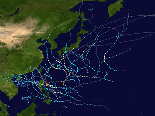
<span class="mw-page-title-main">2000 Pacific typhoon season</span> Typhoon season in the Western Pacific Ocean

The 2000 Pacific typhoon season marked the first year using names contributed by the World Meteorological Organization. It was a rather below-average season, producing a total of 23 tropical storms, 13 typhoons and 4 intense typhoons. The season ran throughout 2000, though typically most tropical cyclones develop between May and October. The season's first named storm, Damrey, developed on May 7, while the season's last named storm, Soulik, dissipated on January 4 of the next year.

<span class="mw-page-title-main">Typhoon</span> Types of tropical cyclone that develops in the Northern Hemisphere

A typhoon is a tropical cyclone that develops between 180° and 100°E in the Northern Hemisphere. This region is referred to as the Northwestern Pacific Basin, accounting for almost one-third of the world's annual tropical cyclones. The term hurricane refers to a tropical cyclone in the northeast Pacific and northern Atlantic. For organizational purposes, the northern Pacific Ocean is divided into three regions: the eastern, central, and western. The Regional Specialized Meteorological Center (RSMC) for tropical cyclone forecasts is in Japan, with other tropical cyclone warning centres for the northwest Pacific in Hawaii, the Philippines, and Hong Kong. Although the RSMC names each system, the main name list itself is coordinated among 18 countries that have territories threatened by typhoons each year.

<span class="mw-page-title-main">Tropical cyclone scales</span> Scales of the intensity of tropical cyclones

Tropical cyclones are ranked on one of five tropical cyclone intensity scales, according to their maximum sustained winds and which tropical cyclone basins they are located in. Only a few scales of classifications are used officially by the meteorological agencies monitoring the tropical cyclones, but other scales also exist, such as accumulated cyclone energy, the Power Dissipation Index, the Integrated Kinetic Energy Index, and the Hurricane Severity Index.

<span class="mw-page-title-main">2011 Pacific typhoon season</span> Typhoon season in the Western Pacific Ocean

The 2011 Pacific typhoon season was a below average season that produced a total of 21 named storms, 8 typhoons, and four super typhoons. This season was much more active than the previous season, although both seasons were below the Pacific typhoon average of 26. The season ran throughout 2011, though most tropical cyclone tend to develop between May and October. The season's first named storm, Aere, developed on May 7 while the season's last named storm, Washi dissipated on December 19.

<span class="mw-page-title-main">Tropical cyclones in 2006</span>

Throughout 2006, 133 tropical cyclones formed in seven bodies of water known as tropical cyclone basins. Of these, 80 have been named, including two tropical cyclones in the South Atlantic Ocean, and a tropical cyclone in the Mediterranean Sea, by various weather agencies when they attained maximum sustained winds of 65 km/h (40 mph). The strongest storms of the year were Typhoon Yagi in the Western Pacific, and Cyclone Glenda of the Australian region. The deadliest and costliest storms of the year were a series of five typhoons that struck the Philippines and China; Chanchu, Bilis, Saomai, Xangsane, and Durian, with most of the damage being caused by Durian of November. So far, 27 Category 3 tropical cyclones formed, including five Category 5 tropical cyclones in the year. The accumulated cyclone energy (ACE) index for the 2006, as calculated by Colorado State University was 761 units.

<span class="mw-page-title-main">Timeline of the 2013 Pacific typhoon season</span>

Most of the tropical cyclones of the 2013 Pacific typhoon season formed between May and November of that year. The scope of this article is the Pacific Ocean north of the equator, between 100°E and the International Date Line. Tropical storms which form in the Western Pacific basin are assigned a name by the Japan Meteorological Agency (JMA). Tropical depressions forming in this basin are given a number with a "W" suffix by the United States' Joint Typhoon Warning Center (JTWC). The Philippine Atmospheric, Geophysical and Astronomical Services Administration (PAGASA) assigns names to tropical cyclones that enter or form in the Philippine area of responsibility, but these names are not in common use outside the Philippines.

<span class="mw-page-title-main">Timeline of the 2014 Pacific typhoon season</span>

This timeline documents all of the events of the 2014 Pacific typhoon season. Most of the tropical cyclones forming between May and November. The scope of this article is limited to the Pacific Ocean, north of the equator between 100°E and the International Date Line. Tropical storms that form in the entire Western Pacific basin are assigned a name by the Japan Meteorological Agency. Tropical depressions that form in this basin are given a number with a "W" suffix by the United States' Joint Typhoon Warning Center. In addition, the Philippine Atmospheric, Geophysical and Astronomical Services Administration (PAGASA) assigns names to tropical cyclones that enter or form in the Philippine area of responsibility. These names, however, are not in common use outside of the Philippines.

<span class="mw-page-title-main">Timeline of the 2015 Pacific typhoon season</span>

This timeline documents all of the events of the 2015 Pacific typhoon season. Most of the tropical cyclones formed between May and November. The scope of this article is limited to the Pacific Ocean, north of the equator between 100°E and the International Date Line. This area, called the Western Pacific basin, is the responsibility of the Japanese Meteorological Agency (JMA). They host and operate the Regional Specialized Meteorological Center (RSMC), located in Tokyo. The Japanese Meteorological Agency (JMA) is also responsible for assigning names to all tropical storms that are formed within the basin. However, any storm that enters or forms in the Philippine Area of Responsibility (PAR) will be named by the Philippine Atmospheric, Geophysical and Astronomical Services Administration (PAGASA) using a local name. Also of note - the Western Pacific basin is monitored by the United States' Joint Typhoon Warning Center (JTWC), which gives all Tropical depressions a number with a "W" suffix.

<span class="mw-page-title-main">Typhoon Meranti</span> Pacific typhoon in 2016

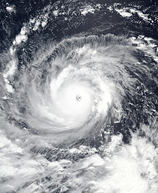
Typhoon Meranti, known in the Philippines as Super Typhoon Ferdie, was one of the most intense tropical cyclones on record. Impacting the Batanes in the Philippines, Taiwan, as well as Fujian Province in September 2016, Meranti formed as a tropical depression on September 8 near the island of Guam. Tracking to the west northwest, Meranti gradually intensified until September 11, at which point it began a period of rapid intensification. Continuing to rapidly intensify, it became a super typhoon early on September 12, as it passed through the Luzon Strait, ultimately reaching its peak intensity on September 13 with 1-minute sustained winds of 315 km/h (195 mph). Shortly afterwards, it passed directly over the island of Itbayat. Meranti passed to the south of Taiwan as a super typhoon, and began weakening steadily as a result of land interaction. By September 15, it struck Fujian Province as a Category 2-equivalent typhoon, becoming the strongest typhoon on record to impact the province. Upon moving inland, rapid weakening ensued and Meranti became extratropical the next day, dissipating shortly afterwards after it passed to the south of the Korean Peninsula.

The 2024 Pacific typhoon season is an upcoming event in the annual cycle of tropical cyclone formation in the western Pacific Ocean. The season runs throughout 2024, though most tropical cyclones typically develop between May and October.

In 2024, tropical cyclones will form in seven major bodies of water, commonly known as tropical cyclone basins. Tropical cyclones will be named by various weather agencies when they attain maximum sustained winds of 35 knots. The year has not started yet, so there is no determined strongest, deadliest, or costliest storm yet.

References

  1. 1 2 WMO/ESCP Typhoon Committee (2019). Typhoon Committee Operational Manual Meteorological Component 2019 (PDF) (Report). World Meteorological Organization. pp. 1–7, 33–34. Retrieved April 29, 2020.
  2. Joint Typhoon Warning Center (2008-03-31). "What are the description labels used with tropical cyclones by JTWC?". Joint Typhoon Warning Center – Frequently Asked Questions (FAQ). Archived from the original on 2013-09-01. Retrieved 2008-12-22.
  3. 1 2 3 Typhoon Committee (2015). Typhoon Committee Operational Manual 2015 (PDF) (Report). World Meteorological Organization. Retrieved November 13, 2015.