
The City of Swan is a local government area of Western Australia. It is in the eastern metropolitan region of Perth and includes the Swan Valley and 42 suburbs. It is centred approximately 20 km north-east of the Perth central business district. The City covers an area of 1,042 km² and had an estimated population of 155,653 in 2020.
Spencers Brook is a waterway, locality and a district located within the Avon Valley in Western Australia.
The Midland line is a suburban rail service on the Transperth network in Perth, Western Australia. It runs on the Eastern Railway through Perth's eastern suburbs and connects Midland with Perth. Travelling from Midland, the trains terminate at Fremantle on the Fremantle line.
The Fremantle line is a suburban railway and service in Western Australia that connects the central business district (CBD) of Perth with Fremantle.

The Division of Hasluck is an electoral division of the Australian House of Representatives, located in Western Australia.

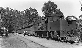
The Eastern Railway is the main railway route between Fremantle and Northam in Western Australia. It opened in stages between 1881 and 1893. The line continues east to Kalgoorlie as the Eastern Goldfields Railway.

The Kalamunda Zig Zag was a zig zag rail line that was part of the Upper Darling Range Railway line in Western Australia, opening in July 1891 and closing in July 1949. Most of it was converted to a public road in 1952, part of which is now a tourist drive called Zig Zag Scenic Drive that offers views of Perth from the hills.

Dowerin is a town 156 kilometres (97 mi) north-east of Perth in the central Wheatbelt region of Western Australia. It is the seat of the Shire of Dowerin.

Western Australian Government Railways (WAGR) was the operator of railway services in the state of Western Australia between October 1890 and June 2003. Owned by the state government, it was renamed a number of times to reflect extra responsibility for tram and ferry operations that it assumed and later relinquished. Westrail was the trading name of WAGR from September 1975 until December 2000, when the WAGR's freight division and the Westrail name and logo were privatised. Its freight operations were privatised in December 2000 with the remaining passenger operations transferred to the Public Transport Authority in July 2003.

The Railway Reserves Heritage Trail – also on some maps as Rail Reserve Heritage Trail or Rail Reserves Historical Trail, and frequently referred to locally as the Bridle Trail or Bridle Track – is within the Shire of Mundaring in Western Australia.
The Mundaring Weir Branch Railway was constructed from Mundaring, Western Australia to the site of the Mundaring Weir, and opened on 1 June 1898.
The Western Line, previously known as the Launceston and Western Line, is a 223 km freight rail corridor that runs from Western Junction to Wiltshire in Tasmania, Australia.

Railways in Western Australia were developed in the 19th century both by the Government of Western Australia and a number of private companies. Today passenger rail services are controlled by the Public Transport Authority through Transperth, which operates public transport in Perth, and Transwa, which operates country passenger services. Great Southern Rail operates the Indian Pacific.

The Midland Junction railway station was an important junction station on the Eastern Railway of Western Australia until its closure in 1966.

The South Western Railway, also known as the South West Main Line, is the main railway route between Perth and Bunbury in Western Australia.
West Swan is a suburb of Perth, Western Australia, located in the City of Swan local government area. It lies west of the Swan River, and east of the former Caversham Motor Racing Circuit. The suburb is traversed by the West Swan Road, one of the main routes in the Swan Valley winery area. At the 2016 Australian census the suburb had a population of 899.
Caversham Airfield, also known as Middle Swan Airfield was an airfield constructed at Caversham, Western Australia during World War II as a parent aerodrome for use by the Royal Navy's Fleet Air Arm and the United States Navy.
Brabham is a suburb located about 21 km (13 mi) north-east of Perth's central business district. The suburb is located in the City of Swan just south of Henley Brook, formerly being a part of that suburb before it was gazetted in May 2011. The suburb was named after Australian motor racing personality Sir Jack Brabham who competed in the 1962 Australian Grand Prix, held at the nearby Caversham Airfield. The suburb is part of the City of Swan's urban growth corridor and is bordered by Park Street to the north, Murray Street to the east, Harrow Street to the south and Drumpellier Drive and Isoondon Street to the west. It is located in the Whiteman Ward of the City of Swan.
The Morley–Ellenbrook line is a planned suburban rail service between the Perth central business district and Ellenbrook in Western Australia. Construction began in 2021 as part of Metronet.

