Mountain View, Arkansas | |
---|---|
City | |
Nickname: Folk Music Capital of the World | |
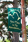
Motto: "Your Place in the Mountains" [1] | |
Coordinates: 35°51′54″N92°6′31″W / 35.86500°N 92.10861°W | |
Country | United States |
State | Arkansas |
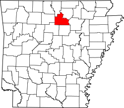
County | Stone |
Government | |
• Mayor | Roger Gardner |
Area | |
• Total | 7.30 sq mi (18.91 km2) |
• Land | 7.30 sq mi (18.90 km2) |
• Water | 0.00 sq mi (0.01 km2) |
Elevation | 755 ft (230 m) |
Population (2020) | |
• Total | 2,877 |
• Density | 394.33/sq mi (152.25/km2) |
Time zone | UTC-6 (Central (CST)) |
• Summer (DST) | UTC-5 (CDT) |
ZIP codes | 72533, 72560 |
Area code | 870 |
FIPS code | 05-47540 |
GNIS feature ID | 2404333 [3] |
Website | www |
Mountain View is the largest city in and the county seat of Stone County, Arkansas, United States, located in the Ozarks. The city's economy is largely based on tourism related to its title as the "Folk Music Capital of the World". [4] The city is also known for outdoors recreation opportunities, including Blanchard Springs Caverns, trout fishing on the White River and the Ozark National Forest.
The town's name is derived from its location in a valley bordered by the Blue Mountain Range of the Ozark Mountains. Mountain View was incorporated on August 14, 1890. [5] Prior to the founding of Mountain View in 1890, the town of Riggsville, established in 1819 by Thomas Augustus Riggs, existed immediately to the east remaining until after the Civil War, when towns with southern sympathies were to be renamed or moved altogether.[ citation needed ]
An EF4 tornado caused major damage to the town on February 5, 2008, in the 2008 Super Tuesday tornado outbreak.
Mountain View is located at 35°51′54″N92°6′31″W / 35.86500°N 92.10861°W (35.864886, −92.108497). [6]
According to the United States Census Bureau, the city has a total area of 6.8 square miles (17.7 km2), of which 6.8 square miles (17.7 km2) is land and 0.15% is water.
The climate in this area is characterized by hot, humid summers and generally mild to cool winters. According to the Köppen Climate Classification system, Mountain View has a humid subtropical climate, abbreviated "Cfa" on climate maps. [7]
Climate data for Mountain View, Arkansas (1991–2020 normals, extremes 1962–present) | |||||||||||||
---|---|---|---|---|---|---|---|---|---|---|---|---|---|
Month | Jan | Feb | Mar | Apr | May | Jun | Jul | Aug | Sep | Oct | Nov | Dec | Year |
Record high °F (°C) | 77 (25) | 83 (28) | 91 (33) | 94 (34) | 95 (35) | 108 (42) | 109 (43) | 114 (46) | 106 (41) | 93 (34) | 88 (31) | 81 (27) | 114 (46) |
Mean maximum °F (°C) | 69.3 (20.7) | 73.5 (23.1) | 80.0 (26.7) | 84.9 (29.4) | 88.6 (31.4) | 94.3 (34.6) | 99.0 (37.2) | 99.3 (37.4) | 95.9 (35.5) | 87.7 (30.9) | 76.8 (24.9) | 69.8 (21.0) | 101.2 (38.4) |
Mean daily maximum °F (°C) | 47.6 (8.7) | 52.8 (11.6) | 61.2 (16.2) | 70.8 (21.6) | 78.1 (25.6) | 86.5 (30.3) | 91.1 (32.8) | 90.5 (32.5) | 83.6 (28.7) | 72.9 (22.7) | 60.5 (15.8) | 50.5 (10.3) | 70.5 (21.4) |
Daily mean °F (°C) | 37.9 (3.3) | 42.3 (5.7) | 50.4 (10.2) | 59.4 (15.2) | 67.7 (19.8) | 76.1 (24.5) | 80.3 (26.8) | 79.1 (26.2) | 71.7 (22.1) | 60.7 (15.9) | 49.7 (9.8) | 40.8 (4.9) | 59.7 (15.4) |
Mean daily minimum °F (°C) | 28.3 (−2.1) | 31.7 (−0.2) | 39.7 (4.3) | 48.0 (8.9) | 57.3 (14.1) | 65.8 (18.8) | 69.5 (20.8) | 67.7 (19.8) | 59.7 (15.4) | 48.6 (9.2) | 39.0 (3.9) | 31.1 (−0.5) | 48.9 (9.4) |
Mean minimum °F (°C) | 9.3 (−12.6) | 13.9 (−10.1) | 19.6 (−6.9) | 30.7 (−0.7) | 39.8 (4.3) | 52.1 (11.2) | 59.0 (15.0) | 56.0 (13.3) | 42.6 (5.9) | 30.4 (−0.9) | 21.4 (−5.9) | 15.2 (−9.3) | 6.6 (−14.1) |
Record low °F (°C) | −12 (−24) | −7 (−22) | 7 (−14) | 21 (−6) | 32 (0) | 42 (6) | 49 (9) | 42 (6) | 30 (−1) | 21 (−6) | 8 (−13) | −9 (−23) | −12 (−24) |
Average precipitation inches (mm) | 3.49 (89) | 3.41 (87) | 4.99 (127) | 5.64 (143) | 5.63 (143) | 3.81 (97) | 3.82 (97) | 3.88 (99) | 3.54 (90) | 4.26 (108) | 5.11 (130) | 4.30 (109) | 51.88 (1,318) |
Average snowfall inches (cm) | 1.2 (3.0) | 1.5 (3.8) | 1.3 (3.3) | 0.0 (0.0) | 0.0 (0.0) | 0.0 (0.0) | 0.0 (0.0) | 0.0 (0.0) | 0.0 (0.0) | 0.0 (0.0) | 0.1 (0.25) | 0.8 (2.0) | 4.9 (12) |
Average precipitation days (≥ 0.01 in) | 7.1 | 6.6 | 9.2 | 8.2 | 10.0 | 7.7 | 8.2 | 7.1 | 6.2 | 7.1 | 7.5 | 7.2 | 92.1 |
Average snowy days (≥ 0.1 in) | 0.6 | 0.6 | 0.3 | 0.0 | 0.0 | 0.0 | 0.0 | 0.0 | 0.0 | 0.0 | 0.1 | 0.5 | 2.1 |
Source: NOAA [8] [9] |
Census | Pop. | Note | %± |
---|---|---|---|
1880 | 99 | — | |
1900 | 226 | — | |
1910 | 272 | 20.4% | |
1920 | 342 | 25.7% | |
1930 | 458 | 33.9% | |
1940 | 745 | 62.7% | |
1950 | 1,043 | 40.0% | |
1960 | 983 | −5.8% | |
1970 | 1,866 | 89.8% | |
1980 | 2,147 | 15.1% | |
1990 | 2,439 | 13.6% | |
2000 | 2,876 | 17.9% | |
2010 | 2,748 | −4.5% | |
2020 | 2,877 | 4.7% | |
U.S. Decennial Census [10] |
Race | Number | Percentage |
---|---|---|
White (non-Hispanic) | 2,641 | 91.8% |
Black or African American (non-Hispanic) | 12 | 0.42% |
Native American | 17 | 0.59% |
Asian | 13 | 0.45% |
Other/Mixed | 126 | 4.38% |
Hispanic or Latino | 68 | 2.36% |
As of the 2020 United States census, there were 2,877 people, 1,273 households, and 540 families residing in the city.
As of the census [12] of 2000, there were 2,876 people, 1,287 households, and 792 families residing in the city. The population density was 421.8 inhabitants per square mile (162.9/km2). There were 1,450 housing units at an average density of 212.7 per square mile (82.1/km2). The racial makeup of the city was 96.97% White, 0.94% Native American, 0.03% Pacific Islander, 0.31% from other races, and 1.74% from two or more races. 1.70% of the population were Hispanic or Latino of any race.
There were 1,287 households, out of which 23.8% had children under the age of 18 living with them, 50.7% were married couples living together, 9.2% had a female householder with no husband present, and 38.4% were non-families. 35.7% of all households were made up of individuals, and 19.0% had someone living alone who was 65 years of age or older. The average household size was 2.13 and the average family size was 2.72.
In the city, the population was spread out, with 20.2% under the age of 18, 7.2% from 18 to 24, 20.7% from 25 to 44, 26.3% from 45 to 64, and 25.7% who were 65 years of age or older. The median age was 47 years. For every 100 females, there were 81.1 males. For every 100 females aged 18 and over, there were 80.3 males.
The median income for a household in the city was $19,302, and the median income for a family was $27,589. Males had a median income of $20,000 versus $16,790 for females. The per capita income for the city was $17,375. About 10.2% of families and 17.0% of the population were below the poverty line, including 19.1% of those under age 18 and 11.7% of those age 65 or over.
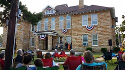
The local economy is largely tourism-based. Numerous hotels and restaurants exist to serve travelers who come to visit the nearby Blanchard Springs Caverns, in Fifty-Six, Arkansas, The Ozark Folk Center State Park, and Loco Ropes Treetop Adventure Park. Many others seek the world-renowned trout fishing of the White River, or the excellent camping, hiking and mountain-biking that can be found in the Ozark National Forest. A few live music and variety shows, such as the White River Hoedown, also entertain travelers by mixing contemporary country, gospel and bluegrass music with a bit of local humor. However, the majority of visitors to Mountain View come to attend one of the two major festivals held here every year, and to enjoy the impromptu folk music jam sessions that occur around the courthouse square.
The remainder of the local economy consists mostly of agriculture, specifically the farming of livestock, primarily cattle and chickens. Large-scale industrial activities in the area are overall nonexistent, excepting a few small manufacturing companies. The Stone County Iron Works, a nationally known company that produces iron furniture, fixtures and housewares, is headquartered in Mountain View. Recently, the city has seen expansion of its personal aircraft maintenance and repair industry.
Stone County, along with four of six neighboring Arkansas counties, is a dry county.
Local festivals play an integral part in Mountain View's economy and culture, and the city is widely known throughout the country for its hospitality, uniqueness and relaxed pace of life. As such, thousands of people travel to Mountain View each year to attend one of these events and get a taste of Ozark Mountain culture. Often lodging must be secured a year in advance of the two major festivals. Some local estimates say that the city's population has grown to as much as 100,000 during past festivals, though this is likely an exaggeration. Average festival attendance tends to fall between 40,000 and 60,000.
In April, the city hosts the Arkansas Folk Festival. A highlight of this festival is an old-fashioned "home-town" parade, which brings out school bands, patriotic veterans groups, show horses, and decorated floats. Numerous folk craft vendors and many impromptu performances of live folk music are also part of the celebration.
During the spring, summer and fall, anytime the weather is nice, people from all over will gather in and around the courthouse square to play and listen to music. Bluegrass mostly, but a wide array of folk, swing, country and gospel can be heard performed by local townsfolk as well as pickers from hundreds of miles away. A few dedicated musicians play only the old-time tunes that have been passed down through generations.
During the fourth weekend of October, thousands attend the Arkansas Bean Fest and Great Championship Outhouse Races. Early Saturday morning, nearly one ton of pinto beans are cooked in large, antique iron kettles that are set up along the west side of the courthouse square. Promptly at noon, a couple thousand pounds of pinto beans and cornbread are served to the gathered crowd. The festival continues with the famous Outhouse Race. Local teams (and anyone who else who wishes to haul in an entry) push outhouses built on wheels (similar to a go-kart) in a series of races. The overall champion receives the coveted Golden Toilet Seat Trophy. Handmade crafts and folk music play an integral part in this festival as well.
Other local festivals included the Mountain View Bluegrass Festival, held in both mid-March and mid-November; An Old-Fashioned Fourth of July; and Mountains Music & Motorcycles in August. The town gets into the holiday spirit each year by lighting downtown buildings for Christmas open house events, and an annual Christmas tree lighting on the first Saturday in December.
The Ozark Folk Center plays host to several events throughout the year, including live concerts by well-known artist such as the Old Crow Medicine Show and Del McCoury, the Arkansas State Fiddle Championships, and workshops teaching banjo, dulcimer, and other folk crafts.
The city hosts a satellite campus of Ozarka College, a two-year institution whose main campus is located in Melbourne, Arkansas. The city is also home to the main campus of the Mountain View School District, a secondary school that also maintains campuses in Timbo, Arkansas and Fox, Arkansas. The school district boundaries are the same as those of Stone County, Arkansas.
Grayson County is a county located in the southwestern part of the Commonwealth of Virginia. As of the 2020 census, the population was 15,333. Its county seat is Independence. Mount Rogers, the state's highest peak at 5,729 feet (1,746 m), is in Grayson County.
Galax is an independent city in the southwestern part of the Commonwealth of Virginia. As of the 2020 census, the population was 6,720.
Howell County is in southern Missouri. As of the 2020 census, the population was 39,750. The largest city and county seat is West Plains. The county was officially organized on March 2, 1851, and is named after Josiah Howell, a pioneer settler in the Howell Valley.
Stone County is located in the Ozark Mountains in the U.S. state of Arkansas. The county is named for rugged, rocky area terrain of the Ozarks. Created as Arkansas's 74th county on April 21, 1873, Stone County has two incorporated cities: Mountain View, the county seat and most populous city, and Fifty-Six. The county is also the site of numerous unincorporated communities and ghost towns.
Franklin County is a county in Arkansas. As of the 2020 census, the population was 17,097. The county has two county seats, Charleston and Ozark. The county was formed on December 19, 1837, and named for Benjamin Franklin, American statesman. Franklin County is a damp county, with alcohol sales allowed except in Prairie & Alix townships, and limits on liquor sales in the city of Branch.
Mountain Home is a city in and the county seat of Baxter County, Arkansas, United States, in the southern Ozark Mountains near the northern state border with Missouri. As of the 2010 census, the city had a population of 12,448. A total of 41,307 persons lived within the city and micropolitan area combined, which encompasses the majority of Baxter County.
The city of Harrison is the county seat of Boone County, Arkansas, United States. It is named after Marcus LaRue Harrison, a surveyor who laid out the city along Crooked Creek at Stifler Springs. According to 2019 Census Bureau estimates, the population of the city was 13,069, up from 12,943 at the 2010 census and it is the 30th largest city in Arkansas based on official 2019 estimates from the U.S. Census Bureau. Harrison is the principal city of the Harrison Micropolitan Statistical Area, which includes all of Boone and Newton counties.
Heber Springs is a city in and the county seat of Cleburne County, Arkansas, United States. The population was 7,165 at the 2010 census.
Ozark is a city in Franklin County, Arkansas, United States and one of the county's two seats of government. The community is located along the Arkansas River in the Arkansas River Valley on the southern edge of the Ozark Mountains. As of the 2010 census it had a population of 3,684.
Salem is the county seat of Fulton County, Arkansas, United States. Salem was first incorporated in 1900. As of the 2010 census the population stood at 1,635.
Batesville is the county seat and largest city of Independence County, Arkansas, United States, 80 miles (183 km) northeast of Little Rock, the state capital. According to the 2010 Census, the population of the city was 10,268. The city serves as a regional manufacturing and distribution hub for the Ozark Mountain region and Northeast Arkansas.
Clarksville is a city in Johnson County, Arkansas, United States. As of the 2010 census the population was 9,178, up from 7,719 in 2000. As of 2018, the estimated population was 9,743. The city is the county seat of Johnson County. It is nestled between the Arkansas River and the foothills of the Ozark Mountains, and Interstate 40 and US Highway 64 intersect within the city limits. Clarksville-Johnson County is widely known for its peaches, scenic byways and abundance of natural outdoor recreational activities.
Paris is a city in Logan County, Arkansas, United States, and serves as the county seat for the northern district of Logan County; its southern district counterpart is Booneville. Its population was 3,176 as of the 2020 U.S. Census.
Yellville is a city in and county seat of Marion County, Arkansas, United States. Yellville is located in the Ozark Mountains along the banks of Crooked Creek, and neighbors the small town of Summit to the north. The population was 1,178 at the 2020 census. The town's original name is preserved in the Shawnee Town Branch, a local creek. The town holds an annual Turkey Trot Festival.
Marshall is the largest city in and county seat of Searcy County in Arkansas, United States. It is located in the Ozarks at the foot of the Boston Mountain Range 10.5 mi (16.9 km) south of America's first National River, the Buffalo National River. Marshall serves as a hub for area tourism including camping, floating, hiking, bicycling and Dark Sky viewing.
Greenland is a city in Washington County, Arkansas, United States. The population is 1,213 as of the 2020 census. The community is located in the Boston Mountains, within the Ozark Mountains.
Ozark is a city in and the county seat of Christian County, Missouri. Its population was 21,284 as of the 2020 census. Ozark is also the third largest city in the Springfield, Missouri Metropolitan Area, and is centered along a business loop of U.S. Route 65, where it intersects with Missouri Route 14.
West Plains is a city in and the county seat of Howell County, Missouri, United States. The population was 12,184 at the 2020 census.
Branson is a city in the U.S. state of Missouri. Most of the city is situated in Taney County, with a small portion in the west extending into Stone County. Branson is in the Ozark Mountains. The community was named after Reuben Branson, postmaster and operator of a general store in the area in the 1880s. The population was 12,638 at the 2020 census.
James Corbitt Morris, known professionally as Jimmy Driftwood or Jimmie Driftwood, was an American folk music songwriter and musician, most famous for his songs "The Battle of New Orleans" and "Tennessee Stud". Driftwood wrote more than 6,000 folk songs, of which more than 300 were recorded by various musicians.