Rice Lake, Minnesota

Last updated

Rice Lake
USA Minnesota location map.svg
Red pog.svg
Rice Lake
Location of the city of Rice Lake
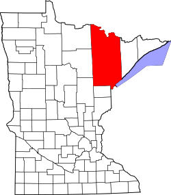
within Saint Louis County, Minnesota
Coordinates: 46°52′45″N92°7′12″W / 46.87917°N 92.12000°W / 46.87917; -92.12000
CountryUnited States
State Minnesota
County Saint Louis
Founded1870
Incorporated October 22, 2015
Government
  MayorJohn Werner
  CouncilSuzanne Herstad
Bob Quade
Jayme Heim
John Hegstrom
Area
[1]
  Total33.15 sq mi (85.85 km2)
  Land32.10 sq mi (83.15 km2)
  Water1.04 sq mi (2.70 km2)
Elevation
1,378 ft (420 m)
Population
 (2020) [2]
  Total4,112
  Estimate 
(2021) [3]
4,101
  Density128.08/sq mi (49.45/km2)
Time zone UTC-6 (CST)
  Summer (DST) UTC-5 (CDT)
ZIP codes
55803
Area code 218
FIPS code 27-54060 [4]
GNIS feature ID0000000 [5]
Website ricelakecitymn.com

Rice Lake is a city in Saint Louis County, Minnesota, United States. The population was 4,112 at the 2020 census. [2]

Contents

Main routes include Rice Lake Road (County Road 4) and Martin Road (County Road 9).

Rice Lake Road runs north–south, and Martin Road runs east–west. Other routes include Howard Gnesen Road, Arnold Road, Calvary Road, West Tischer Road, and West Beyer Road.

History

Rice Lake was founded as a township in 1870.

After portions of the township had been annexed by the city of Duluth, the residents began the process to be recognized as a city. [6] On August 20, 2015, Administrative Law Judge Barbara J. Case signed an Order of Incorporation which allowed the township of Rice Lake to convert into the city of Rice Lake. [7] [6] [8]

In an election held on October 13, 2015, Rice Lake residents elected a mayor and members of the city council. [6] [8] The results of the election were certified. The township was formally organized as a city on October 22, 2015. [9]

Geography

According to the United States Census Bureau, the township has a total area of 33.5 square miles (87 km2); 32.3 square miles (84 km2) is land and 1.1 square miles (2.8 km2), or 3.43%, is water.

Wild Rice Lake is partially located within the city of Rice Lake, giving it its name. [10]

Amity Creek and the East Branch of Amity Creek both flow through the city.

The Lester River rises in nearby Gnesen Township and flows generally southeastwardly through the city of Rice Lake and Lakewood Township, turning southward as it nears Lake Superior. The river flows into Lake Superior in eastern Duluth.

Adjacent townships, cities, and communities

The following are adjacent to Rice Lake:

The Duluth International Airport is to the immediate southwest of the city of Rice Lake.

Ridgeview Road runs east–west along Rice Lake's southern boundary line with adjacent city of Duluth.

Lismore Road runs east–west along Rice Lake's northern boundary line with adjacent Gnesen Township.

Jean Duluth Road (County Road 37) runs north–south along Rice Lake's eastern boundary line with adjacent Lakewood Township; except for the southeast corner of Rice Lake where both Arnold Road and Martin Road together serve as the boundary line with adjacent city of Duluth.

Town Line Road briefly runs north–south along Rice Lake's western boundary line with adjacent Canosia Township.

Demographics

Historical population
CensusPop.Note
1880 63
1890 169168.3%
1900 23136.7%
1910 580151.1%
1920 91657.9%
1930 1,57371.7%
1940 2,30046.2%
1950 2,83823.4%
1960 3,61527.4%
1970 3,359−7.1%
1980 3,86114.9%
1990 3,8830.6%
2000 4,1396.6%
2010 4,099−1.0%
2020 4,1120.3%
2021 (est.)4,101 [3] −0.3%
U.S. Decennial Census [11]
2020 Census [2]

2000 census

As of the census of 2000, there were 4,139 people, 1,494 households, and 1,177 families residing in the township. The population density was 127.9 inhabitants per square mile (49.4/km2). There were 1,518 housing units at an average density of 46.9 per square mile (18.1/km2). The racial makeup of the township was 97.83% White, 0.29% African American, 0.58% Native American, 0.24% Asian, 0.10% Pacific Islander, 0.10% from other races, and 0.87% from two or more races. Hispanic or Latino of any race were 0.41% of the population.

There were 1,494 households, out of which 37.3% had children under the age of 18 living with them, 68.8% were married couples living together, 6.2% had a female householder with no husband present, and 21.2% were non-families. 16.8% of all households were made up of individuals, and 5.3% had someone living alone who was 65 years of age or older. The average household size was 2.77 and the average family size was 3.10.

In the township the population was spread out, with 27.5% under the age of 18, 7.2% from 18 to 24, 31.0% from 25 to 44, 24.9% from 45 to 64, and 9.4% who were 65 years of age or older. The median age was 38 years. For every 100 females, there were 103.1 males. For every 100 females age 18 and over, there were 104.9 males.

The median income for a household in the township was $51,341, and the median income for a family was $55,357. Males had a median income of $39,894 versus $28,095 for females. The per capita income for the township was $18,857. About 4.7% of families and 5.5% of the population were below the poverty line, including 4.9% of those under age 18 and 6.5% of those age 65 or over.

Politics

2000-2020 precinct results
Year Republican Democratic Third parties
2020 [12] 47.0% 1,29051.0%1,4012.0% 55
2016 [13] 44.5% 1,09047.6%1,1677.9% 194
2012 [14] 36.5% 89461.4%1,5032.1% 51
2008 [15] 36.0% 89261.9%1,5362.1% 53
2004 [16] 37.1% 91262.2%1,5280.7% 16
2000 [17] 33.9% 72759.2%1,2696.9% 148

Related Research Articles

<span class="mw-page-title-main">St. Louis County, Minnesota</span> County in Minnesota, United States

St. Louis County is a county located in the Arrowhead Region of the U.S. state of Minnesota. As of the 2020 census, the population was 200,231. Its county seat is Duluth. It is the largest county in Minnesota by land area, and the largest in the United States by total area east of the Mississippi River. St. Louis County is included in the Duluth, MN–Superior, WI Metropolitan Statistical Area.

Camden Township is a rural township in Carver County, Minnesota, United States. The population was 955 as of the 2000 census.

Dahlgren Township is a rural township in Carver County, Minnesota, United States. The township's economy is based on commercial agriculture around dairying, livestock and cash grain farming. The population was 1,453 as of the 2000 census.

<span class="mw-page-title-main">Nisswa, Minnesota</span> City in Minnesota, United States

Nisswa is a city in Crow Wing County, Minnesota, United States. The population was 1,971 at the 2010 census. Nisswa is part of the Brainerd Micropolitan Statistical Area, near Gull Lake.

<span class="mw-page-title-main">Apple Valley, Minnesota</span> City in Minnesota, United States

Apple Valley is a city in northwestern Dakota County in the State of Minnesota, and a suburb of the Twin Cities. The population was 56,374 at the 2020 census, making it the 17th most populous city in Minnesota.

<span class="mw-page-title-main">Tonka Bay, Minnesota</span> City in Minnesota, United States

Tonka Bay is a city in Hennepin County, Minnesota, United States. It is on Lake Minnetonka between the upper and lower lakes. It gained some popularity in the 1880s and 1890s as a summer lake resort. The population was 1,475 at the 2010 census.

Angora Township is a township in Saint Louis County, Minnesota, United States. The population was 249 at the 2010 census. Angora Township was named after Angora, in Turkey.

Canosia Township is an urban township in Saint Louis County, Minnesota, United States. Canosia is a name derived from the Algonquian language meaning "pike fish". The population was 2,158 at the 2010 census.

Cherry Township is a township in Saint Louis County, Minnesota, United States. The population was 860 at the 2010 census.

Duluth Township is a township in Saint Louis County, Minnesota, United States. The population was 1,941 at the 2010 census.

Fredenberg Township is a township in Saint Louis County, Minnesota, United States. The population was 1,337 at the 2010 census.

Gnesen Township is a township in Saint Louis County, Minnesota, United States. The population was 1,683 at the 2010 census.

Grand Lake Township is a township in Saint Louis County, Minnesota, United States. The population was 2,779 at the 2010 census.

<span class="mw-page-title-main">Hermantown, Minnesota</span> City in Minnesota, United States

Hermantown is a city in Saint Louis County, Minnesota, United States. The population was 10,221 at the 2020 census. A suburb of Duluth, it was at one point the county's only city to grow in population, as much of the area's residential and commercial expansion occurred there. Hermantown is near the tip of Lake Superior.

Lakewood Township is a township in Saint Louis County, Minnesota, United States. The population was 2,252 in 2018 as estimated by the Minnesota State Demographic Center.

Midway Township is a township in Saint Louis County, Minnesota, United States. The population was 1,399 at the 2010 census.

Normanna Township is a township in Saint Louis County, Minnesota, United States. The population was 796 at the 2010 census.

North Star Township is a township in Saint Louis County, Minnesota, United States. The population was 190 at the 2010 census.

Solway Township is a township in Saint Louis County, Minnesota, United States. The population was 1,944 at the 2010 census. Solway Township was named after Solway Firth.

<span class="mw-page-title-main">New Germany, Minnesota</span> City in Minnesota, United States

New Germany is a city in Carver County, Minnesota, United States. The population was 372 at the 2010 census. A large proportion of the early settlers being natives of Germany caused the name to be selected.

References

  1. "2020 U.S. Gazetteer Files". United States Census Bureau. Retrieved July 24, 2022.
  2. 1 2 3 "Explore Census Data". United States Census Bureau . Retrieved March 15, 2023.
  3. 1 2 "City and Town Population Totals: 2020-2021". United States Census Bureau. March 15, 2023. Retrieved March 15, 2023.
  4. "U.S. Census website". United States Census Bureau . Retrieved January 31, 2008.
  5. "US Board on Geographic Names". United States Geological Survey. October 25, 2007. Retrieved January 31, 2008.
  6. 1 2 3 "Rice Lake Township is Minnesota's newest city". Mesabi Daily News. August 24, 2015. Retrieved October 15, 2015.
  7. Case, Barbara J. (August 20, 2015). "Order: In the Matter of the Petition for Incorporation of Rice Lake Township" (PDF). State of Minnesota. Retrieved October 15, 2015.
  8. 1 2 Turtinen, Melissa (August 24, 2015). "Let's make it 853: Rice Lake Township will be Minnesota's newest city". Bring Me the News. Retrieved October 15, 2015.
  9. "Rice Lake City Council holds first meeting". Duluth News Tribune. Duluth, Minnesota. October 22, 2015. Retrieved October 29, 2015.
  10. Upham, Warren (1920). Minnesota geographic names; their origin and historic significance. Minnesota Historical Society. p. 489 via Archive.org.
  11. United States Census Bureau. "Census of Population and Housing" . Retrieved September 11, 2013.
  12. "Minnesota Secretary of State - 2020 Precinct Results Spreadsheet".
  13. "Minnesota Secretary of State - 2016 Precinct Results Spreadsheet".
  14. "Minnesota Secretary of State - 2012 Precinct Results Spreadsheet".
  15. "Minnesota Secretary of State - 2008 Precinct Results Spreadsheet".
  16. "Minnesota Secretary of State - 2004 Precinct Results Spreadsheet".
  17. "Minnesota Secretary of State - 2000 Precinct Results Spreadsheet".