Sandalfoot Cove, Florida

Last updated
Sandalfoot Cove, Florida
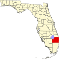
FLMap-doton-SandalfootCove.PNG
The location of Sandalfoot Cove, Florida.
Coordinates: 26°20′20″N80°11′7″W / 26.33889°N 80.18528°W / 26.33889; -80.18528 Coordinates: 26°20′20″N80°11′7″W / 26.33889°N 80.18528°W / 26.33889; -80.18528
Country Flag of the United States.svg  United States
State Flag of Florida.svg  Florida
County   Palm Beach
Area
  Total3.0 sq mi (7.7 km2)
  Land3.0 sq mi (7.7 km2)
  Water0.0 sq mi (0.0 km2)
Elevation
13 ft (4 m)
Population
 (2000)
  Total16,582
  Density5,587.0/sq mi (2,157.1/km2)
Time zone UTC-5 (Eastern (EST))
  Summer (DST) UTC-4 (EDT)
FIPS code 12-63450 [1]
GNIS feature ID1867199 [2]

Sandalfoot Cove was a census-designated place (CDP) located in an unincorporated area near Boca Raton in Palm Beach County, Florida, United States. The population was 16,582 at the 2000 census. While it is not officially in the City of Boca Raton, the community is frequently classified under its umbrella term.

Contents

Geography

Sandalfoot Cove is located at 26°20′20″N80°11′07″W / 26.338873°N 80.185315°W / 26.338873; -80.185315 , [3] or about five miles southwest of Boca Raton.

According to the United States Census Bureau, the CDP has a total area of 7.7 km2 (3.0 mi2), all land.

Although the defined western border stops at U.S. Route 441; the area directly west is also generally referred to by residents as Sandalfoot as well. Sandalfoot Boulevard continues west of 441. This area includes the Watergate Estates mobile homes, Boca Trails, Palmetto Pines, Boca Springs, and Tudor Woods.

Demographics

As of the census [1] of 2000, there were 16,582 people, 6,895 households, and 4,592 families residing in the CDP. The population density was 2,155.7/km2 (5,587.0/mi2). There were 7,743 housing units at an average density of 1,006.6/km2 (2,608.9/mi2). The racial makeup of the CDP was 87.21% White (76.4% were Non-Hispanic White,) [4] 3.96% African American, 0.15% Native American, 2.97% Asian, 0.05% Pacific Islander, 3.29% from other races, and 2.37% from two or more races. Hispanic or Latino of any race were 14.46% of the population.

There were 6,895 households, out of which 30.1% had children under the age of 18 living with them, 51.8% were married couples living together, 11.4% had a female householder with no husband present, and 33.4% were non-families. 25.8% of all households were made up of individuals, and 12.2% had someone living alone who was 65 years of age or older. The average household size was 2.40 and the average family size was 2.91.

In the CDP, the population was spread out, with 22.3% under the age of 18, 6.3% from 18 to 24, 30.9% from 25 to 44, 21.1% from 45 to 64, and 19.4% who were 65 years of age or older. The median age was 39 years. For every 100 females, there were 90.6 males. For every 100 females age 18 and over, there were 85.8 males.

The median income for a household in the CDP was $44,243, and the median income for a family was $49,871. Males had a median income of $39,774 versus $29,920 for females. The per capita income for the CDP was $23,232. About 3.3% of families and 5.0% of the population were below the poverty line, including 5.4% of those under age 18 and 3.3% of those age 65 or over.

As of 2000, English was the first language for 76.91% of all residents, while Spanish accounted for 14.88%, Portuguese consisted of 3.18%, Italian made up 1.72%, Yiddish was totaled at 0.66%, Vietnamese totaled 0.56%, both French and German were at 0.46%, French Creole was at 0.43%, Arabic at 0.39%, and Hebrew was the mother tongue for 0.29% of the population. [5]

The CDP is home to a sizable and growing number of immigrants, most notably Brazilian and Colombian; as well as Haitian. This can be seen in the shopping centers south of Judge Winikoff road, along 441, where there are a number of Brazilian and Colombian restaurants and markets within the area.

Crime

Sandalfoot Cove, along with the area directly west, has a reputation as being one of the parts of unincorporated Boca Raton with the highest crime rate. [6] Likely due to the generally working class population, which is in contrast to the mostly lower middle class to upper middle class population in surrounding areas. The CDP has a significant presence of drugs and prostitution. [7] [8] [9] [10] [11]

Related Research Articles

Palm Aire, Florida was an unincorporated census-designated place in Broward County, Florida consisting of residential property, commercial businesses, and four golf courses. Palm Aire describes both Palm Aire Village, a collection of single-family houses, and Palm Aire Country Club, a 5,000-acre (20 km2) property with condominiums, villas, estate homes, and four golf courses. It is now part of the cities of Fort Lauderdale and Pompano Beach.

Palm River-Clair Mel, Florida Census-designated place in Florida, United States

Palm River-Clair Mel is a census-designated place (CDP) in Hillsborough County, Florida, United States. The population was 21,024 at the 2010 census, up from 17,589 at the 2000 census. The census area includes the unincorporated communities of Clair-Mel City and Palm River. The ZIP code for Palm River-Clair Mel is 33619.

Tice, Florida Census-designated place in Florida, United States

Tice is an unincorporated community and census-designated place (CDP) in Lee County, Florida, United States. As of the 2010 census, the CDP population was 4,470. It is part of the Cape Coral-Fort Myers, Florida Metropolitan Statistical Area.

Palm City, Florida CDP in Florida, United States

Palm City is a census-designated place (CDP) in Martin County, Florida, United States. The population was 23,120 at the 2010 census. It is part of the Port St. Lucie Metropolitan Statistical Area.

Key Largo, Florida CDP in Florida, United States

Key Largo is a census-designated place in Monroe County, Florida, United States, located on the island of Key Largo in the upper Florida Keys. The population was 10,433 at the 2010 census. The name comes from the Spanish Cayo Largo, or "long key". It is both the first island and town of the Florida Keys to be reached from the Overseas Highway to Key West. It was also the location of one of the stations of the Overseas Railroad.

Belle Glade Camp, Florida unincorporated place in Florida, United States

Belle Glade Camp was a census-designated place (CDP) in Palm Beach County, Florida, United States. The population was 1,141 at the 2000 census.

Boca Del Mar, Florida unincorporated place in Florida, United States

Boca Del Mar was a census-designated place (CDP) in an unincorporated area near Boca Raton in Palm Beach County, Florida, United States. The population was 21,832 at the 2000 census. While it is not officially in the City of Boca Raton, the community is often classified under its umbrella term.

Boca Pointe, Florida unincorporated place in Florida, United States

Boca Pointe was a census-designated place (CDP) located in an unincorporated area near Boca Raton in Palm Beach County, Florida, United States. The population was 3,302 at the 2000 census. The CDP was not included in the 2010 census. While it is not officially in the City of Boca Raton, the community is frequently classified under its umbrella term.

Canal Point, Florida CDP in Florida, United States

Canal Point is a census-designated place (CDP) in Palm Beach County, Florida, United States. Canal Point is located along the eastern shore of Lake Okeechobee, to the northeast of Pahokee and to the northwest of Bryant. The unincorporated community was originally inhabited by the Calusa tribe until almost 400 years ago. Whites began occupying the area in the 1900s decade, establishing an agrarian community. The completion of the West Palm Beach Canal in 1917 allowed crops to be shipped by boat to West Palm Beach and then to other areas of the country, while construction of Conners Highway in 1924 resulted in crops being transported by motor vehicle.

There are four "Century Villages" in south Florida, built by the same developer: West Palm Beach, Boca Raton, Deerfield Beach, and Pembroke Pines. This article deals only with the West Palm Beach Century Village, the only one designated a census-designated place (CDP). All of them are gated retirement communities, whose residents must be 55 or over.

Hamptons at Boca Raton, Florida unincorporated place in Florida, United States

Hamptons at Boca Raton was a census-designated place (CDP) located in an unincorporated area near Boca Raton in Palm Beach County, Florida, United States. The population was 11,306 at the 2000 census. While it is not officially in the City of Boca Raton, the community is frequently classified under its umbrella term.

High Point was a census-designated place (CDP) in Palm Beach County, Florida, United States. The population was 2,191 at the 2000 census. The CDP was removed from the 2010 census. Although it is still unincorporated, it is within Delray Beach's "future annexation area."

Lakeside Green, Florida unincorporated place in Florida, United States

Lakeside Green was a census-designated place (CDP) in Palm Beach County, Florida, United States. The population was 3,311 at the 2000 census.

Mission Bay, Florida unincorporated place in Florida, United States

Mission Bay is a census-designated place (CDP) located in an unincorporated area in Boca Raton in Palm Beach County, Florida, United States. The population was 2,926 at the 2000 census.

Royal Palm Estates is a census-designated place (CDP) in Palm Beach County, Florida, United States. The population was 3,583 at the 2000 census.

Whisper Walk, Florida unincorporated place in Florida, United States

Whisper Walk was a census-designated place (CDP) located in an unincorporated area northwest of Boca Raton in Palm Beach County, Florida, United States. The population was 5,135 at the 2000 census. While it is not in the city of Boca Raton, Boca Raton is its postal address, and the community is frequently classified under its umbrella term.

Lake Worth Corridor was an unincorporated census-designated place in Palm Beach County, Florida, United States, approximately three miles west of the city of Lake Worth. The population was 18,663 at the 2000 census. The CDP was not included in the 2010 census.

Zephyr Cove–Round Hill Village, Nevada Former CDP in Nevada, United States

Zephyr Cove–Round Hill Village is a former census-designated place (CDP) in Douglas County, Nevada, United States. The population was 1,649 at the 2000 census. For the 2010 census, the area was split into the Zephyr Cove and Round Hill Village CDPs.

Woodbury, Nassau County, New York Hamlet and census-designated place in New York, United States

Woodbury is a hamlet and census-designated place (CDP) located within the town of Oyster Bay in Nassau County, New York, United States. The population was 8,907 at the 2010 census. The ZIP code of the Woodbury post office is 11797.

Junction City, Washington Census-designated place in Washington, United States

Junction City is a census-designated place (CDP) in Grays Harbor County, Washington, United States. The population was 18 at the 2010 census.

References

  1. 1 2 "U.S. Census website". United States Census Bureau . Retrieved 2008-01-31.
  2. "US Board on Geographic Names". United States Geological Survey. 2007-10-25. Retrieved 2008-01-31.
  3. "US Gazetteer files: 2010, 2000, and 1990". United States Census Bureau. 2011-02-12. Retrieved 2011-04-23.
  4. "Demographics of Sandalfoot Cove, FL". MuniNetGuide.com. Retrieved 2007-12-14.
  5. "MLA Data Center Results for Sandalfoot Cove, Florida". Modern Language Association . Retrieved 2007-12-14.
  6. "Crime-O-Meter of Palm Beach County (Metropolitan West Palm Beach)". www.google.com. Retrieved 2017-07-21.
  7. "SWAT Raid Shatters Boca Raton Stigma - Palm Partners Blog". Palm Partners Blog. 2014-10-20. Retrieved 2017-07-21.
  8. "Big Drug Bust in West Sandalfoot – West Boca News" . Retrieved 2017-07-21.
  9. "PBSO: West Boca drug raid leads to three arrests". palmbeachpost. Retrieved 2017-07-21.
  10. Salley, Farron, 80-year-old man arrested in prostitution sting , retrieved 2017-07-21
  11. "7 Johns Busted in Publix Prostitution Sting – West Boca News" . Retrieved 2017-07-21.