Buffalo County | |
---|---|
Coordinates: 44°05′N99°12′W / 44.08°N 99.2°W | |
Country | United States |
State | South Dakota |
Founded | 1864 (created) 1871 (organized) |
Named for | American buffalo |
Seat | Gann Valley |
Largest community | Fort Thompson |
Area | |
• Total | 488 sq mi (1,260 km2) |
• Land | 471 sq mi (1,220 km2) |
• Water | 16 sq mi (40 km2) 3.4% |
Population (2020) | |
• Total | 1,948 |
• Estimate (2023) | 1,884 |
• Density | 4.0/sq mi (1.5/km2) |
Time zone | UTC−6 (Central) |
• Summer (DST) | UTC−5 (CDT) |
Congressional district | At-large |
Website | https://buffalo.sdcounties.org/ |
Buffalo County is a county in the U.S. state of South Dakota. As of the 2020 census, the population was 1,948. [1] Its county seat is Gann Valley [2] which, at 10 people, is the least populous county seat in the United States. The county was created in 1864, and was organized in 1871 [3] as part of the Dakota Territory.
In 2010, the center of population of South Dakota was located in eastern Buffalo County. [4] The Crow Creek Indian Reservation, inhabited by the Crow Creek Sioux Tribe, makes up the majority of Buffalo County.
According to the 2013 Small Area Income and Poverty Estimates of the U.S. Census Bureau, about 41% of county residents live in poverty, making it the fifth-poorest county in South Dakota. This is a far higher poverty rate than the national poverty rate of 15.8%. Median household income in 2013 was $21,572, making it the lowest-earning county in South Dakota and the United States. [5]
In March 2019, the county unemployment rate was 3.9%; its ten-year peaks occurred in December 2006 (18.1%) and December 2009 (17.2%). [6] As of 2002 [update] , many homes lack kitchens and indoor plumbing. [7]
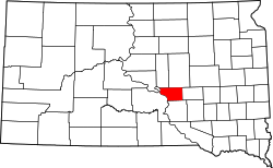
The Missouri River flows southerly along the county's western boundary. The county terrain consists of semi-arid rolling hills, generally sloping to the south and east. Some area is devoted to agriculture. The south and west parts of the county are drained by Crow Creek, which discharges into the river at the county's SW corner. The county has a total area of 488 square miles (1,260 km2), of which 471 square miles (1,220 km2) is land and 16 square miles (41 km2) (3.4%) is water. [8]
As first organized, the county occupied an extensive area, bounded on the north by Canada, southwest and west by the Missouri River, having Montana for a part of its northwest boundary, and comprising a large portion of the "Plateau du Coteau du Missouri", and a part of the Miniwakan or Devil's Lake. [9] Thus, its original boundary also contained a portion of the future North Dakota, which became a separate unit when the Dakota Territory was admitted into the Union in 1889 as two separate states.
Census | Pop. | Note | %± |
---|---|---|---|
1870 | 246 | — | |
1880 | 63 | −74.4% | |
1890 | 993 | 1,476.2% | |
1900 | 1,790 | 80.3% | |
1910 | 1,589 | −11.2% | |
1920 | 1,715 | 7.9% | |
1930 | 1,931 | 12.6% | |
1940 | 1,853 | −4.0% | |
1950 | 1,615 | −12.8% | |
1960 | 1,547 | −4.2% | |
1970 | 1,739 | 12.4% | |
1980 | 1,795 | 3.2% | |
1990 | 1,759 | −2.0% | |
2000 | 2,032 | 15.5% | |
2010 | 1,912 | −5.9% | |
2020 | 1,948 | 1.9% | |
2023 (est.) | 1,884 | [10] | −3.3% |
U.S. Decennial Census [11] 1790-1960 [12] 1900-1990 [13] 1990-2000 [14] 2010-2020 [1] |
As of the 2020 census, there were 1,948 people, 497 households, and 393 families residing in the county. [15] The population density was 4.1 inhabitants per square mile (1.6/km2). There were 570 housing units.
As of the 2010 census, there were 1,912 people, 532 households, and 407 families in the county. The population density was 4.1 inhabitants per square mile (1.6/km2). There were 609 housing units at an average density of 1.3 per square mile (0.50/km2). The racial makeup of the county was 84.0% Native American, 14.8% white, 0.2% black or African American, 0.1% Asian, 0.0% from other races, and 0.9% from two or more races. Those of Hispanic or Latino origin made up 1.8% of the population. In terms of ancestry, 5.6% were German, and 0.0% were American.
Of the 532 households, 55.6% had children under the age of 18 living with them, 33.1% were married couples living together, 33.1% had a female householder with no husband present, 23.5% were non-families, and 19.0% of all households were made up of individuals. The average household size was 3.59 and the average family size was 4.06. The median age was 25.0 years.
The median income for a household in the county was $27,926 and the median income for a family was $28,333. Males had a median income of $38,920 versus $18,542 for females. The per capita income for the county was $11,410. About 44.4% of families and 49.3% of the population were below the poverty line, including 58.2% of those under age 18 and 36.3% of those age 65 or over.
Democratic Party nominees have won Buffalo County in every presidential election since 1956 except the 1980 and 1984 elections, which Ronald Reagan won. However, many people in Buffalo County are also socially conservative, with this county being the only one in the state to both vote for Kamala Harris for president and vote against 2024 South Dakota Amendment G, which would have established a right to abortion in South Dakota's constitution. [20]
Year | Republican | Democratic | Third party(ies) | |||
---|---|---|---|---|---|---|
No. | % | No. | % | No. | % | |
2024 | 164 | 35.19% | 291 | 62.45% | 11 | 2.36% |
2020 | 183 | 33.33% | 352 | 64.12% | 14 | 2.55% |
2016 | 171 | 34.90% | 296 | 60.41% | 23 | 4.69% |
2012 | 166 | 25.90% | 472 | 73.63% | 3 | 0.47% |
2008 | 156 | 25.20% | 454 | 73.34% | 9 | 1.45% |
2004 | 223 | 26.52% | 603 | 71.70% | 15 | 1.78% |
2000 | 140 | 34.31% | 256 | 62.75% | 12 | 2.94% |
1996 | 134 | 20.94% | 465 | 72.66% | 41 | 6.41% |
1992 | 137 | 27.62% | 282 | 56.85% | 77 | 15.52% |
1988 | 151 | 30.82% | 334 | 68.16% | 5 | 1.02% |
1984 | 253 | 51.21% | 236 | 47.77% | 5 | 1.01% |
1980 | 272 | 59.65% | 147 | 32.24% | 37 | 8.11% |
1976 | 194 | 44.70% | 240 | 55.30% | 0 | 0.00% |
1972 | 221 | 44.47% | 275 | 55.33% | 1 | 0.20% |
1968 | 261 | 47.11% | 265 | 47.83% | 28 | 5.05% |
1964 | 278 | 35.69% | 501 | 64.31% | 0 | 0.00% |
1960 | 294 | 46.82% | 334 | 53.18% | 0 | 0.00% |
1956 | 314 | 49.68% | 318 | 50.32% | 0 | 0.00% |
1952 | 413 | 61.46% | 259 | 38.54% | 0 | 0.00% |
1948 | 313 | 48.01% | 334 | 51.23% | 5 | 0.77% |
1944 | 324 | 56.45% | 250 | 43.55% | 0 | 0.00% |
1940 | 491 | 55.42% | 395 | 44.58% | 0 | 0.00% |
1936 | 368 | 46.29% | 410 | 51.57% | 17 | 2.14% |
1932 | 270 | 29.64% | 634 | 69.59% | 7 | 0.77% |
1928 | 405 | 51.01% | 387 | 48.74% | 2 | 0.25% |
1924 | 309 | 41.53% | 225 | 30.24% | 210 | 28.23% |
1920 | 200 | 59.70% | 101 | 30.15% | 34 | 10.15% |
1916 | 80 | 30.19% | 182 | 68.68% | 3 | 1.13% |
1912 | 0 | 0.00% | 105 | 53.85% | 90 | 46.15% |
1908 | 105 | 58.99% | 69 | 38.76% | 4 | 2.25% |
1904 | 118 | 60.51% | 43 | 22.05% | 34 | 17.44% |
1900 | 87 | 46.28% | 100 | 53.19% | 1 | 0.53% |
1896 | 68 | 46.26% | 79 | 53.74% | 0 | 0.00% |
1892 | 78 | 50.65% | 13 | 8.44% | 63 | 40.91% |
Stanley County is a county in the U.S. state of South Dakota. As of the 2020 census, the population was 2,980. Its county seat is Fort Pierre. The county was created in 1873, and was organized in 1890. It is named for David S. Stanley, a commander at Fort Sully from 1866 to 1874, which was located nearby.
Sanborn County is a county in the U.S. state of South Dakota. As of the 2020 census, the population was 2,330. Its county seat and largest city is Woonsocket. The county was created by the Dakota Territorial legislature on May 1, 1883, with land partitioned from Miner County. It was fully organized by July 18, 1883.
Perkins County is a county in the U.S. state of South Dakota. As of the 2020 census, the population was 2,835. Its county seat is Bison. The county was established in 1908 and organized in 1909. It was named for Sturgis, South Dakota, official Henry E. Perkins.
Mellette County is a county in the U.S. state of South Dakota. As of the 2020 census, the population was 1,918. Its county seat is White River. The county was created in 1909, and was organized in 1911. It was named for Arthur C. Mellette, the last Governor of the Dakota Territory and the first Governor of the state of South Dakota.
Marshall County is a county in the U.S. state of South Dakota. As of the 2020 census, the population was 4,306. Its county seat is Britton. The county was created on May 2, 1885, and was named for Marshall Vincent, who homesteaded near Andover, South Dakota.
Lawrence County is a county in the U.S. state of South Dakota. As of the 2020 census, the population was 25,768, making it the 8th most populous county in South Dakota. Its county seat is Deadwood.
Lake County is a county in the U.S. state of South Dakota. As of the 2020 census, the population was 11,059. Its county seat is Madison. The county was formed in 1873.
Jones County is a county in the U.S. state of South Dakota. As of the 2020 census, the population was 917, making it the least populous county in South Dakota. Its county seat is Murdo. Created in 1916 and organized in 1917, it is the most recently established county in South Dakota. It was named after Granville Whittington Jones, an Arkansas-born clergyman/lawyer, who moved to Chamberlain, SD and became a noted Chautauqua speaker.
Jerauld County is a county in the U.S. state of South Dakota. As of the 2020 census, the population was 1,663. Its county seat is Wessington Springs.
Hyde County is a county in the U.S. state of South Dakota. As of the 2020 census, the population was 1,262, making it the second-least populous county in South Dakota. Its county seat is Highmore. The county was founded in 1873, as a county of the Dakota Territory, and organized in 1883. It was named for James Hyde, a member of legislature in the 1870s.
Hughes County is a county in the U.S. state of South Dakota. As of the 2020 census, the population was 17,765, making it the least populous capital county in the nation, and the 12th most populous county in South Dakota. Its county seat is Pierre, which is also the state capital. The county was created in 1873, and was organized in 1880. It was named for Alexander Hughes, a legislator. On June 4, 1891, the county's area was increased by the addition of Farm Island, in the Missouri River downstream of Pierre.
Gregory County is a county in the U.S. state of South Dakota. As of the 2020 census, the population was 3,994. Its county seat is Burke. The county was created in 1862 and organized in 1898. It was named for the politician J. Shaw Gregory.
Dewey County is a county in the U.S. state of South Dakota. As of the 2020 census, the population was 5,239. Its county seat is Timber Lake. The county was created in 1883 and organized in 1910. It was named for William P. Dewey, Territorial surveyor-general from 1873 to 1877.
Day County is a county in the U.S. state of South Dakota. As of the 2020 census, the population was 5,449. Its county seat is Webster. The county is named for Merritt H. Day, pioneer and 1879 Dakota Territory legislator.
Custer County is a county in the U.S. state of South Dakota. As of the 2020 census, the population was 8,318. Its county seat is Custer. The county was created in 1875, and was organized in 1877. It was named after General George Armstrong Custer.
Corson County is a county in the U.S. state of South Dakota. As of the 2020 census, the population was 3,902. Its county seat is McIntosh. The county was named for Dighton Corson, a native of Maine, who came to the Black Hills in 1876, and in 1877 began practicing law at Deadwood.
Campbell County is a county in the U.S. state of South Dakota. As of the 2020 census, the population was 1,377, making it the fourth-least populous county in South Dakota. Its county seat is Mound City. The county was created in 1873 and organized in 1884. It was named for Norman B. Campbell, a Dakota Territory legislator in 1873 and son of General Charles T. Campbell.
Brule County is a county in the U.S. state of South Dakota. As of the 2020 census, the population was 5,247. Its county seat is Chamberlain.
Bon Homme County is a county in the U.S. state of South Dakota. As of the 2020 census, the population was 7,003. Its county seat is Tyndall.
Fort Thompson is a census-designated place (CDP) in Buffalo County, South Dakota, United States. The population was 1,282 at the 2010 census, making it the largest settlement on the Crow Creek Reservation.