Eau Claire County | |
---|---|
Coordinates: 44°44′N91°17′W / 44.73°N 91.29°W | |
Country | United States |
State | Wisconsin |
Founded | 1856 [1] |
Named for | Eau Claire River |
Seat | Eau Claire |
Largest city | Eau Claire |
Government | |
• County Administrator | Kathryn Schauf |
Area | |
• Total | 645 sq mi (1,670 km2) |
• Land | 638 sq mi (1,650 km2) |
• Water | 7.3 sq mi (19 km2) 1.1% |
Population | |
• Total | 105,710 |
• Estimate (2023) | 107,903 |
• Density | 165.7/sq mi (64.0/km2) |
Time zone | UTC−6 (Central) |
• Summer (DST) | UTC−5 (CDT) |
Congressional district | 3rd |
Website | www |
Eau Claire County is a county located in the U.S. state of Wisconsin. As of the 2020 census, the population was 105,710. [3] Its county seat is Eau Claire. [4] The county took its name from the Eau Claire River. [5]
Eau Claire County is included in the Eau Claire, WI Metropolitan Statistical Area as well as the Eau Claire-Menomonie WI Combined Statistical Area.
Eau Claire county was originally set off as the Town of Clearwater in Chippewa County in 1855. The name was changed to the Town of Eau Claire on March 31, 1856. The entire town was separated as Eau Claire County by an act of the Wisconsin State Legislature on October 6, 1856. [6] [7]
According to the U.S. Census Bureau, the county has a total area of 645 square miles (1,670 km2), of which 638 square miles (1,650 km2) is land and 7.3 square miles (19 km2) (1.1%) is water. [8]
Census | Pop. | Note | %± |
---|---|---|---|
1860 | 3,162 | — | |
1870 | 10,769 | 240.6% | |
1880 | 19,993 | 85.7% | |
1890 | 30,673 | 53.4% | |
1900 | 31,692 | 3.3% | |
1910 | 32,721 | 3.2% | |
1920 | 35,771 | 9.3% | |
1930 | 41,087 | 14.9% | |
1940 | 46,999 | 14.4% | |
1950 | 54,187 | 15.3% | |
1960 | 58,300 | 7.6% | |
1970 | 67,219 | 15.3% | |
1980 | 78,805 | 17.2% | |
1990 | 85,183 | 8.1% | |
2000 | 93,142 | 9.3% | |
2010 | 98,736 | 6.0% | |
2020 | 105,710 | 7.1% | |
U.S. Decennial Census [9] 1790–1960 [10] 1900–1990 [11] 1990–2000 [12] 2010 [13] 2020 [2] |
As of the census of 2020, [2] the population was 105,710. The population density was 165.7 people per square mile (64.0 people/km2). There were 44,966 housing units at an average density of 70.5 units per square mile (27.2 units/km2). The racial makeup of the county was 88.2% White, 4.2% Asian, 1.2% Black or African American, 0.5% Native American, 0.1% Pacific Islander, 1.1% from other races, and 4.7% from two or more races. Ethnically, the population was 2.9% Hispanic or Latino of any race.
As of the census [14] of 2000, there were 93,142 people, 35,822 households, and 22,281 families residing in the county. The population density was 146 people per square mile (56 people/km2). There were 37,474 housing units at an average density of 59 units per square mile (23 units/km2). The racial makeup of the county was 94.96% White, 0.52% Black or African American, 0.54% Native American, 2.52% Asian, 0.03% Pacific Islander, 0.33% from other races, and 1.11% from two or more races. 0.94% of the population were Hispanic or Latino of any race. 37.4% were of German, 21.5% Norwegian and 7.0% Irish ancestry. 94.2% spoke English, 1.6% Hmong, 1.6% Spanish and 1.0% German as their first language.
There were 35,822 households, out of which 30.00% had children under the age of 18 living with them, 50.60% were married couples living together, 8.60% had a female householder with no husband present, and 37.80% were non-families. 27.10% of all households were made up of individuals, and 10.10% had someone living alone who was 65 years of age or older. The average household size was 2.46 and the average family size was 3.02.
In the county, the population was spread out, with 23.40% under the age of 18, 17.10% from 18 to 24, 26.70% from 25 to 44, 20.50% from 45 to 64, and 12.20% who were 65 years of age or older. The median age was 32 years. For every 100 females, there were 93.80 males. For every 100 females age 18 and over, there were 90.60 males.
In 2017, there were 1,191 births, giving a general fertility rate of 52.8 births per 1000 women aged 15–44, the tenth lowest rate out of all 72 Wisconsin counties. Of these, 99 of the births occurred at home, the third highest for Wisconsin counties. [15]
In 2010, the largest religious groups by reported number of adherents were Catholic at 16,240 adherents, ELCA Lutheran at 15,067 adherents, Missouri Synod Lutheran at 6,953 adherents, LCMC Lutheran at 3,355 adherents, United Methodist at 2,177 adherents, non-denominational Christian at 1,557 adherents, Lutheran Brethren at 1,391 adherents, United Church of Christ at 1,046 adherents, Assemblies of God at 969 adherents, Amish at 794 adherents, Wisconsin Synod Lutheran at 757 adherents, ELS Lutheran at 708 adherents, and LDS (Mormon) at 703 adherents. [16]
Eau Claire county is served by the Chippewa Valley Regional Airport (KEAU).
The legislative body of Eau Claire County is the non-partisan 29-member Eau Claire County Board of Supervisors. [17] Members of the board of supervisors are elected by district and the chairperson and vice-chair positions are elected from within members of the board.
The board meets in the Eau Claire County Courthouse in downtown Eau Claire, [18] with its weekly meetings televised on local public television and transcripts published online. Most items are approved on a "consent calendar" without discussion. [19] Public comment is limited to three minutes per individual per item.
Eau Claire County contains portions of the Wisconsin State Senate districts 23 and 31, represented by Kathy Bernier (R) and Jeff Smith (D) respectively. It also contains portions of Wisconsin State Assembly districts 68 (Jesse James [R]) and 93 (Warren Petryk [R]), as well as almost all of district 91 (Jodi Emerson [D]). At the federal level, the entire county is contained within Wisconsin's third congressional district, which is represented in the United States House of Representatives by Derrick Van Orden (R). At the Presidential level Eau Claire is solidly Democratic, having last voted Republican in 1984 for Ronald Reagan in his landslide re-election. Since 1984 the closest a Republican has come to winning Eau Claire was in 2000 when George W. Bush lost the county by 6.6 percent.
Year | Republican | Democratic | Third party(ies) | |||
---|---|---|---|---|---|---|
No. | % | No. | % | No. | % | |
2020 | 25,341 | 43.49% | 31,620 | 54.26% | 1,314 | 2.25% |
2016 | 23,331 | 42.40% | 27,340 | 49.69% | 4,354 | 7.91% |
2012 | 23,256 | 42.43% | 30,666 | 55.95% | 884 | 1.61% |
2008 | 20,959 | 38.10% | 33,146 | 60.25% | 905 | 1.65% |
2004 | 24,653 | 44.47% | 30,068 | 54.24% | 716 | 1.29% |
2000 | 20,921 | 43.70% | 24,078 | 50.29% | 2,876 | 6.01% |
1996 | 13,900 | 34.41% | 20,298 | 50.26% | 6,192 | 15.33% |
1992 | 15,915 | 33.81% | 21,221 | 45.08% | 9,940 | 21.11% |
1988 | 17,664 | 45.27% | 21,150 | 54.20% | 209 | 0.54% |
1984 | 20,401 | 51.09% | 19,347 | 48.45% | 181 | 0.45% |
1980 | 17,304 | 44.46% | 17,602 | 45.22% | 4,016 | 10.32% |
1976 | 16,388 | 46.36% | 18,263 | 51.66% | 702 | 1.99% |
1972 | 15,883 | 51.33% | 14,300 | 46.21% | 760 | 2.46% |
1968 | 11,799 | 46.66% | 12,302 | 48.65% | 1,186 | 4.69% |
1964 | 8,700 | 35.48% | 15,775 | 64.33% | 46 | 0.19% |
1960 | 14,427 | 56.13% | 11,240 | 43.73% | 37 | 0.14% |
1956 | 13,122 | 58.48% | 9,276 | 41.34% | 41 | 0.18% |
1952 | 14,069 | 59.47% | 9,554 | 40.38% | 35 | 0.15% |
1948 | 7,825 | 43.37% | 9,971 | 55.27% | 246 | 1.36% |
1944 | 9,470 | 51.13% | 8,962 | 48.39% | 88 | 0.48% |
1940 | 9,595 | 48.38% | 10,129 | 51.07% | 108 | 0.54% |
1936 | 6,802 | 39.41% | 10,065 | 58.31% | 393 | 2.28% |
1932 | 7,487 | 48.80% | 7,565 | 49.31% | 291 | 1.90% |
1928 | 10,079 | 69.25% | 4,385 | 30.13% | 91 | 0.63% |
1924 | 5,149 | 46.46% | 629 | 5.68% | 5,305 | 47.87% |
1920 | 7,856 | 81.62% | 1,193 | 12.39% | 576 | 5.98% |
1916 | 2,922 | 53.00% | 2,290 | 41.54% | 301 | 5.46% |
1912 | 2,013 | 40.29% | 1,727 | 34.57% | 1,256 | 25.14% |
1908 | 3,981 | 64.50% | 1,859 | 30.12% | 332 | 5.38% |
1904 | 4,343 | 73.08% | 1,224 | 20.60% | 376 | 6.33% |
1900 | 4,378 | 66.44% | 1,967 | 29.85% | 244 | 3.70% |
1896 | 4,522 | 63.42% | 2,364 | 33.16% | 244 | 3.42% |
1892 | 2,719 | 47.80% | 2,383 | 41.90% | 586 | 10.30% |
Attractions include the Chippewa Valley Museum in Eau Claire, Dells Mill Museum in Augusta, Dells Mill Water Powered Museum in Augusta, the Paul Bunyan Logging Camp in Eau Claire, and the Sarge Boyd Bandshell in Eau Claire. [22]
‡ Historical community
§ Now part of the City of Eau Claire
Vernon County is a county in the U.S. state of Wisconsin. As of the 2020 census, the population was 30,714. Its county seat is Viroqua.
Sawyer County is a county in the U.S. state of Wisconsin. As of the 2020 census, its population was 18,074. Its county seat is Hayward. The county partly overlaps with the reservation of the Lac Courte Oreilles Band of Lake Superior Chippewa Indians.
Monroe County is a county in the U.S. state of Wisconsin. As of the 2020 census, the population was 46,274. Its county seat is Sparta.
Milwaukee County is a county located in the U.S. state of Wisconsin. At the 2020 census, the population was 939,489, down from 947,735 in 2010. It is both the most populous and most densely populated county in Wisconsin, and the 45th most populous county nationwide; Milwaukee, its eponymous county seat, is also the most populous city in the state. The county was created in 1834 as part of Michigan Territory and organized the following year.
Green Lake County is a county located in the U.S. state of Wisconsin. As of the 2020 census, the population was 19,018. Its county seat is Green Lake. In 2020, the center of population of Wisconsin was located in Green Lake County, near the city of Markesan.
Dunn County is a county in the U.S. state of Wisconsin. As of the 2020 census, the population was 45,440. Its county seat is Menomonie. Dunn County comprises the Menomonie Micropolitan Statistical Area and is included in the Eau Claire-Menomonie, WI Combined Statistical Area.
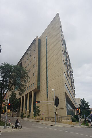
Dane County is a county in the U.S. state of Wisconsin. As of the 2020 census, the population was 561,504, making it the second-most populous county in Wisconsin after Milwaukee County. The county seat is Madison, which is also the state capital. Dane County is the central county of the Madison metropolitan area, as well as the Madison–Janesville–Beloit combined statistical area.
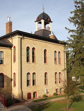
Clark County is a county in the U.S. state of Wisconsin. As of the 2020 census, the population was 34,659. Its county seat is Neillsville.
Chippewa County is a county located in the U.S. state of Wisconsin. It is named for the historic Chippewa people, also known as the Ojibwe, who long controlled this territory. As of the 2020 census, the population was 66,297. Its county seat is Chippewa Falls. The county was founded in 1845 from Crawford County, then in the Wisconsin Territory, and organized in 1853.
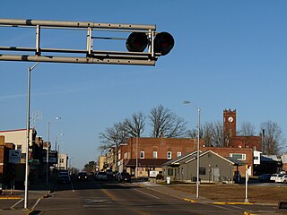
Chippewa Falls is a city located on the Chippewa River in Chippewa County, Wisconsin, United States. The population was 14,731 in the 2020 census. Incorporated as a city in 1869, it is the county seat of Chippewa County.
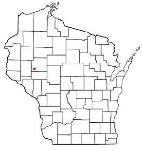
Stanley is a city in Chippewa and Clark counties in the U.S. state of Wisconsin. The population was 3,608 at the 2010 census. Of this, 3,602 were in Chippewa County, and 6 in Clark County.
The Town of Wheaton is located in Chippewa County in the U.S. state of Wisconsin. The population was 2,701 at the 2010 census, up from 2,366 at the 2000 census. The unincorporated communities of Old Albertville and Pine Grove are located in the town.
Altoona is a city in Eau Claire County, Wisconsin, United States. The population was 8,292 at the 2020 census with an estimated population in 2022 of 9,149. The city is a railroad terminal on the Union Pacific Railroad.
Augusta is a city in Eau Claire County, Wisconsin, United States. The population was 1,550 at the 2010 census. The city is bordered by the Town of Bridge Creek.
Fall Creek is a village in Eau Claire County, Wisconsin, United States. The population was 1,315 at the 2010 census. The village is bordered by the Town of Lincoln.
Eau Claire is a city in Eau Claire and Chippewa counties in the U.S. state of Wisconsin. It is the seat of Eau Claire County. It had a population of 69,421 in 2020, making it the state's eighth-most populous city. It is the principal city of the Eau Claire metropolitan area, locally known as the Chippewa Valley, which had 172,007 residents in 2020.
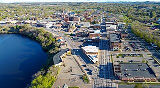
Rice Lake is a city in Barron County in northwest Wisconsin, United States, on the shore of the lake with the same name. The city is a commercial and tourist center for the surrounding rural areas. As of the 2020 census, the city had a total population of 9,040. The city is located mostly within the Town of Rice Lake.
Menomonie is a city in and the county seat of Dunn County in the western part of the U.S. state of Wisconsin. The city's population was 16,843 as of the 2020 census.
Fairchild is a village in Eau Claire County, Wisconsin, United States. The population was 550 at the 2010 census. The village is located within the Town of Fairchild.
Lake Hallie is a village in Chippewa County, Wisconsin, United States. It was incorporated from part of the Town of Hallie on February 18, 2003. The 2010 census put the village's population at 6,448.
{{cite web}}
: CS1 maint: archived copy as title (link)