Enderby Plain

Last updated

Enderby Plain (also known as Enderby Abyssal Plain or East Abyssal Plain) ( 60°S40°E / 60°S 40°E / -60; 40 Coordinates: 60°S40°E / 60°S 40°E / -60; 40 ) is an undersea plain (or abyssal plain ), located off the coast of Enderby Land and Queen Maud Land, East Antarctica. The name was approved by the U.S. Board on Geographic Names Advisory Committee on Undersea Features in June 1988. [1]

Geographic coordinate system Coordinate system

A geographic coordinate system is a coordinate system that enables every location on Earth to be specified by a set of numbers, letters or symbols. The coordinates are often chosen such that one of the numbers represents a vertical position and two or three of the numbers represent a horizontal position; alternatively, a geographic position may be expressed in a combined three-dimensional Cartesian vector. A common choice of coordinates is latitude, longitude and elevation. To specify a location on a plane requires a map projection.

Abyssal plain Flat area on the deep ocean floor

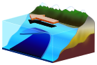
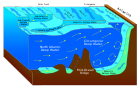
An abyssal plain is an underwater plain on the deep ocean floor, usually found at depths between 3,000 metres (9,800 ft) and 6,000 metres (20,000 ft). Lying generally between the foot of a continental rise and a mid-ocean ridge, abyssal plains cover more than 50% of the Earth’s surface. They are among the flattest, smoothest, and least explored regions on Earth. Abyssal plains are key geologic elements of oceanic basins.

Enderby Land geographical object

Enderby Land is a projecting land mass of Antarctica. Its shore extends from Shinnan Glacier at about 67°55′S44°38′E to William Scoresby Bay at 67°24′S59°34′E, approximately ​124 of the earth's longitude. It was first documented in western and eastern literature in February 1831 by John Biscoe aboard the whaling brig Tula, and named after the Enderby Brothers of London, the ship's owners who encouraged their captains to combine exploration with sealing.

This submarine terrain feature is named after the Enderby Brothers, owners of a 19th-century whaling company based in London, England. The company sponsored several expeditions to Antarctica in the mid-19th century.

Samuel Enderby & Sons was a whaling and sealing company based in London, England, founded circa 1775 by Samuel Enderby (1717–1797). The company encouraged their captains to combine exploration with their business activities, and sponsored several of the earliest expeditions to the subantarctic, Southern Ocean and Antarctica itself.

Whaling hunting of whales

Whaling is the hunting of whales for their usable products such as meat and blubber, which can be turned into a type of oil which became increasingly important in the Industrial Revolution. It was practiced as an organized industry as early as 875 AD. By the 16th century, it had risen to be the principle industry in the coastal regions of Spain and France. The industry spread throughout the world, and became increasingly profitable in terms of trade and resources. Some regions of the world's oceans, along the animals' migration routes, had a particularly dense whale population, and became the targets for large concentrations of whaling ships, and the industry continued to grow well into the 20th century. The depletion of some whale species to near extinction led to the banning of whaling in many countries by 1969, and to a worldwide cessation of whaling as an industry in the late 1980s. The earliest forms of whaling date to at least circa 3000 BC. Coastal communities around the world have long histories of subsistence use of cetaceans, by dolphin drive hunting and by harvesting drift whales. Industrial whaling emerged with organized fleets of whaleships in the 17th century; competitive national whaling industries in the 18th and 19th centuries; and the introduction of factory ships along with the concept of whale harvesting in the first half of the 20th century. By the late 1930s more than 50,000 whales were killed annually. In 1986, the International Whaling Commission (IWC) banned commercial whaling because of the extreme depletion of most of the whale stocks.

Antarctica Polar continent in the Earths southern hemisphere

Antarctica is Earth's southernmost continent. It contains the geographic South Pole and is situated in the Antarctic region of the Southern Hemisphere, almost entirely south of the Antarctic Circle, and is surrounded by the Southern Ocean. At 14,000,000 square kilometres, it is the fifth-largest continent. For comparison, Antarctica is nearly twice the size of Australia. About 98% of Antarctica is covered by ice that averages 1.9 km in thickness, which extends to all but the northernmost reaches of the Antarctic Peninsula.

See also

Related Research Articles

Beaver Glacier (Enderby Land) glacier in Enderby Land, Antarctica

Beaver Glacier is a glacier about 15 miles (24 km) long and 4 miles (6 km) wide, flowing west into Amundsen Bay between Auster Glacier and Mount Gleadell. The head of Beaver Glacier is located very close to the base of Mount King in Enderby Land. It was visited by an Australian National Antarctic Research Expeditions (ANARE) party on October 28, 1956, and named after the Beaver aircraft used by ANARE in coastal exploration.

Scott Mountains (Antarctica) mountain range in Antarctica

The Scott Mountains are a large number of isolated peaks lying south of Amundsen Bay in Enderby Land of East Antarctica, Antarctica. Discovered on 13 January 1930 by the British Australian New Zealand Antarctic Research Expedition (BANZARE) under Sir Douglas Mawson. He named the feature Scott Range after Captain Robert Falcon Scott, Royal Navy. The term mountains is considered more appropriate because of the isolation of its individual features.

Endurance Ridge is an Antarctic undersea ridge, south-east of Coronation Island in the South Atlantic Ocean. It was named after the Endurance Expedition of 1914–1917, and its name was approved by the Advisory Committee for Undersea Features in June 1987.

Kichenside Glacier glacier in Antarctica

Kichenside Glacier is a glacier, 15 nautical miles (28 km) long and 3 to 5 nautical miles wide, flowing northeast into the southern part of the Hannan Ice Shelf on the coast of Enderby Land, Antarctica. It was charted from air photos taken from an Australian National Antarctic Research Expeditions aircraft in 1956, and was named by the Antarctic Names Committee of Australia for Squadron Leader James C. Kichenside, RAAF, officer commanding the Antarctic Flight at Mawson Station in 1960.

Assender Glacier glacier in Antarctica

Assender Glacier is a glacier flowing west into Spooner Bay in Enderby Land, Antarctica. It was plotted from air photos taken from Australian National Antarctic Research Expeditions aircraft in 1956, and named by the Antarctic Names Committee of Australia for Pilot Officer Ken J. Assender, RAAF, pilot at Mawson Station in 1959.

Newman Nunataks

Mount Breckinridge

Mount Breckinridge is a mountain, 2,050 metres (6,730 ft) high, standing 4 nautical miles (7 km) south of Stor Hånakken Mountain in the Napier Mountains of Enderby Land, Antarctica. It was mapped by Norwegian cartographers from aerial photos taken by the Lars Christensen Expedition of 1936–37, and was named "Langnuten". It was rephotographed by the Australian National Antarctic Research Expeditions in 1956 and renamed by the Antarctic Names Committee of Australia for J.E. Breckinridge a meteorologist at Wilkes Station in 1961.

Rippon Glacier glacier in Antarctica

Rippon Glacier is a small glacier located in Kemp Land, East Antarctica. It is close east of Seaton Glacier, flowing southward into Edward VIII Ice Shelf.

The Gromov Nunataks are a group of nunataks lying 7 nautical miles (13 km) east-southeast of Mount Henry in the Scott Mountains of Enderby Land, Antarctica. They were named by the Soviet Antarctic Expedition, 1961–62, for M.M. Gromov, a Soviet pilot.

Graham Peak is a peak about 7 nautical miles (13 km) east of Mount Riiser-Larsen in the northwestern part of the Tula Mountains in Enderby Land, Antarctica. It was plotted from air photos taken from Australian National Antarctic Research Expeditions aircraft in 1956, and was named by the Antarctic Names Committee of Australia for N. Graham, a cook at Wilkes Station in 1960.

Mount Merrick is a mountain, 1,120 metres (3,670 ft) high, standing 3 nautical miles (6 km) west of Mount Humble in the Raggatt Mountains of Antarctica. It is about 20 nautical miles (37 km) south-east of Casey Bay in Enderby Land. The mountain was plotted from air photos taken by the Australian National Antarctic Research Expeditions in 1956 and 1957, and was named by the Antarctic Names Committee of Australia for Robert William Merrick, a geophysicist at Mawson Station in 1960.

Mount Hardy is a mountain standing close east of Mount Oldfield in the northwest part of the Tula Mountains, in Enderby Land, Antarctica. It was plotted from air photos taken from Australian National Antarctic Research Expeditions aircraft in 1956 and was named by the Antarctic Names Committee of Australia for K. Hardy, a weather observer at Wilkes Station in 1959.

Litke Nunatak is a nunatak 10 nautical miles (19 km) east of the Perov Nunataks, lying at the eastern margin of the Scott Mountains in Enderby Land, Antarctica. It was named by the Soviet Antarctic Expedition, 1961–62, after the Soviet icebreaker Litke.

Hays Glacier glacier in Antarctica

Hays Glacier is a glacier flowing north into the head of Spooner Bay, Enderby Land, Antarctica. It was plotted from air photos taken by the Australian National Antarctic Research Expeditions (ANARE) in 1956, and was named for J. Hays, a United States observer with the ANARE which made a landing nearby.

Cape Markov is an ice cape on the east side of Amundsen Bay, situated 7 nautical miles (13 km) west of Mount Riiser-Larsen in Enderby Land, Antarctica. It was named by the Soviet Antarctic Expedition, 1961–62, for K.K. Markov, professor of geography at Moscow State University, and the author of a number of reports on Antarctica.

Mount Keyser is a mountain 3 nautical miles (6 km) east of Mount Ryder, in the eastern part of the Tula Mountains in Enderby Land, Antarctica. It was plotted from air photos taken from Australian National Antarctic Research Expeditions aircraft in 1957, and was named by the Antarctic Names Committee of Australia for D.O. Keyser, a radio officer at Mawson Station in 1961.

Lamykin Dome is a domed feature rising to 525 metres (1,720 ft) which forms the ice-covered summit of Tange Promontory, on the coast of Enderby Land, Antarctica. The feature was plotted on charts by the Soviet Antarctic Expedition (1957) and named for Soviet hydrographer S.M. Lamykin.

References

PD-icon.svg This article incorporates  public domain material from the United States Geological Survey document "Enderby Plain" (content from the Geographic Names Information System ).

United States Geological Survey Scientific agency of the United States government

The United States Geological Survey is a scientific agency of the United States government. The scientists of the USGS study the landscape of the United States, its natural resources, and the natural hazards that threaten it. The organization has four major science disciplines, concerning biology, geography, geology, and hydrology. The USGS is a fact-finding research organization with no regulatory responsibility.

Geographic Names Information System geographical database

The Geographic Names Information System (GNIS) is a database that contains name and locative information about more than two million physical and cultural features located throughout the United States of America and its territories. It is a type of gazetteer. GNIS was developed by the United States Geological Survey in cooperation with the United States Board on Geographic Names (BGN) to promote the standardization of feature names.