Ocean Surface Topography Mission

Last updated
Ocean Surface Topography Mission

OSTM-06.jpg

Artist's interpretation of the Jason-2 satellite
Mission type Earth orbiter
Operator NASA, NOAA, CNES, EUMETSAT
COSPAR ID 2008-032A
SATCAT no. 33105
Website Ocean Surface Topography from Space
Mission duration Design: 3 years
Elapsed: 9 years, 10 months and 27 days
Spacecraft properties
Bus Proteus
Manufacturer Thales Alenia Space
Launch mass 510 kilograms (1,120 lb)
Start of mission
Launch date June 20, 2008, 07:46:25 (2008-06-20UTC07:46:25Z) UTC
Rocket Delta II 7320-10C D334
Launch site Vandenberg SLC-2W
Contractor ULA
Orbital parameters
Reference system Geocentric
Regime LEO
Semi-major axis 7,715.0 kilometers (4,793.9 mi)
Eccentricity 0.0007611
Perigee 1,332 kilometers (828 mi)
Apogee 1,343 kilometers (835 mi)
Inclination 66,03°
Period 6754.0 seconds
RAAN 301,7746 degrees
Argument of perigee 273,8057 degrees
Mean anomaly 280,076 degrees
Epoch 09 April 2016 21:16:10 UTC
Jason-2 after separation from its carrier rocket OSTM sep.jpg
Jason-2 after separation from its carrier rocket

The Ocean Surface Topography Mission (OSTM) on the Jason-2 satellite [1] is an international Earth observation satellite mission that continues the sea surface height measurements begun in 1992 by the joint NASA/CNES TOPEX/Poseidon mission [2] and followed by the NASA/CNES Jason-1 mission launched in 2001. [3]

Earth observation satellite non-military satellite specifically designed to observe Earth from orbit

An Earth observation satellite or Earth remote sensing satellite is satellite specifically designed for Earth observation from orbit, similar to spy satellites but intended for non-military uses such as environmental monitoring, meteorology, map making etc. The first occurrence of satellite remote sensing can be dated to the launch of the first artificial satellite, Sputnik 1, by the Soviet Union on October 4, 1957. Sputnik 1 sent back radio signals, which scientists used to study the ionosphere. NASA launched the first American satellite, Explorer 1, in January 31, 1958. The information sent back from its radiation detector led to the discovery of the Earth's Van Allen radiation belts. The TIROS-1 spacecraft, launched on April 1, 1960 as part of NASA's TIROS Program, sent back the first television footage of weather patterns to be taken from space. As of 2008, more than 150 Earth observation satellites were in orbit, recording data with both passive and active sensors and acquiring more than 10 terabits of data daily.

Sea level Average level for the surface of the ocean at any given geographical position on the planetary surface

Mean sea level (MSL) is an average level of the surface of one or more of Earth's oceans from which heights such as elevation may be measured. MSL is a type of vertical datum – a standardised geodetic datum – that is used, for example, as a chart datum in cartography and marine navigation, or, in aviation, as the standard sea level at which atmospheric pressure is measured to calibrate altitude and, consequently, aircraft flight levels. A common and relatively straightforward mean sea-level standard is the midpoint between a mean low and mean high tide at a particular location.

TOPEX/Poseidon Satellite mission to map ocean surface topography

TOPEX/Poseidon was a joint satellite mission between NASA, the U.S. space agency; and CNES, the French space agency, to map ocean surface topography. Launched on August 10, 1992, it was the first major oceanographic research satellite. TOPEX/Poseidon helped revolutionize oceanography by providing data previously impossible to obtain. Oceanographer Walter Munk described TOPEX/Poseidon as "the most successful ocean experiment of all time." A malfunction ended normal satellite operations in January 2006.

Contents

History

Like its two predecessors, OSTM/Jason-2 uses high-precision ocean altimetry to measure the distance between the satellite and the ocean surface to within a few centimeters. These very accurate observations of variations in sea surface height—also known as ocean topography—provide information about global sea level, the speed and direction of ocean currents, and heat stored in the ocean.

Ocean current Directional mass flow of oceanic water generated by external or internal forces

An ocean current is a continuous, directed movement of sea water generated by a number of forces acting upon the water, including wind, the Coriolis effect, breaking waves, cabbeling, and temperature and salinity differences. Depth contours, shoreline configurations, and interactions with other currents influence a current's direction and strength. Ocean currents are primarily horizontal water movements.

Jason-2 was built by Thales Alenia Space using a Proteus platform, under a contract from CNES, as well as the main Jason-2 instrument, the Poseidon-3 altimeter (successor to the Poseidon and Poseidon 2 altimeter on-board TOPEX/Poseidon and Jason-1)

Thales Alenia Space Franco-Italian aerospace manufacturer

Thales Alenia Space is a Franco-Italian aerospace manufacturer formed after the Thales Group bought the participation of Alcatel in the two joint-ventures between Alcatel and Leonardo, Alcatel Alenia Space and Telespazio. The company is Europe's largest satellite manufacturer, and was responsible for the manufacturing of the ESA built modules of the International Space Station.

Proteus is the name of the multimission platform satellite developed by CNES and Aérospatiale Satellite Division in France.

Jason-1 Satellite oceanography mission

Jason-1 was a satellite oceanography mission to monitor global ocean circulation, study the ties between the ocean and the atmosphere, improve global climate forecasts and predictions, and monitor events such as El Niño and ocean eddies.

Scientists consider the 15-plus-year climate data record that this mission will extend critical understanding how ocean circulation is linked to global climate change.

Climate Statistics of weather conditions in a given region over long periods

Climate is defined as the average state of everyday's weather condition over a period of 30 years. It is measured by assessing the patterns of variation in temperature, humidity, atmospheric pressure, wind, precipitation, atmospheric particle count and other meteorological variables in a given region over long periods of time. Climate differs from weather, in that weather only describes the short-term conditions of these variables in a given region.

Climate change Change in the statistical distribution of weather patterns for an extended period

Climate change occurs when changes in Earth's climate system result in new weather patterns that last for at least a few decades, and maybe for millions of years. The climate system is comprised of five interacting parts, the atmosphere (air), hydrosphere (water), cryosphere, biosphere, and lithosphere. The climate system receives nearly all of its energy from the sun, with a relatively tiny amount from earth's interior. The climate system also gives off energy to outer space. The balance of incoming and outgoing energy, and the passage of the energy through the climate system, determines Earth's energy budget. When the incoming energy is greater than the outgoing energy, earth's energy budget is positive and the climate system is warming. If more energy goes out, the energy budget is negative and earth experiences cooling.

OSTM/Jason-2 was launched at 07:46 UTC on June 20, 2008, from Space Launch Complex 2W at the Vandenberg Air Force Base in California, USA, by a Delta II 7320 rocket. [4] The spacecraft separated from the rocket 55 minutes later. [5]

Vandenberg AFB Space Launch Complex 2 rocket launch site at Vandenberg Air Force Base in the USA

Space Launch Complex 2 (SLC-2) is an inactive rocket launch site at Vandenberg Air Force Base, in California, USA. It consists of two launch pads. The East pad (SLC-2E), which has been demolished, was used for Delta, Thor-Agena and Thorad launches between 1966 and 1972. The West pad, SLC-2W, was used for Delta, Thor-Agena and Delta II launches from 1966 until 2018, when the Delta II performed its last flight.

Vandenberg Air Force Base census-designated place in California, United States

Vandenberg Air Force Base is a United States Air Force Base 9.2 miles (14.8 km) northwest of Lompoc, California. It is under the jurisdiction of the 30th Space Wing, Air Force Space Command (AFSPC).

California State of the United States of America

California is a state in the Pacific Region of the United States. With 39.6 million residents, California is the most populous U.S. state and the third-largest by area. The state capital is Sacramento. The Greater Los Angeles Area and the San Francisco Bay Area are the nation's second- and fifth-most populous urban regions, with 18.7 million and 9.7 million residents respectively. Los Angeles is California's most populous city, and the country's second-most populous, after New York City. California also has the nation's most populous county, Los Angeles County, and its largest county by area, San Bernardino County. The City and County of San Francisco is both the country's second-most densely populated major city after New York City and the fifth-most densely populated county, behind only four of the five New York City boroughs.

It is now in a 1,336 km (830 mi) circular, non-sun-synchronous orbit at an inclination of 66 degrees to Earth's equator, allowing it to monitor 95 percent of Earth's ice-free ocean every 10 days. Jason-1 has been moved to the opposite side of Earth and now flies over the same region of the ocean that Jason-2 flew over five days earlier. [6] Jason-1's ground tracks fall midway between those of Jason-2, which are about 315 kilometers (196 mi) apart at the equator. This interleaved tandem mission provides twice the number of measurements of the ocean's surface, bringing smaller features such as ocean eddies into view. The tandem mission also helps pave the way for a future ocean altimeter mission that would collect much more detailed data with its single instrument than the two Jason satellites now do together.

Orbit gravitationally curved path of an object around a point in outer space; circular or elliptical path of one object around another object

In physics, an orbit is the gravitationally curved trajectory of an object, such as the trajectory of a planet around a star or a natural satellite around a planet. Normally, orbit refers to a regularly repeating trajectory, although it may also refer to a non-repeating trajectory. To a close approximation, planets and satellites follow elliptic orbits, with the central mass being orbited at a focal point of the ellipse, as described by Kepler's laws of planetary motion.

With OSTM/Jason-2, ocean altimetry makes the transition from research into operational mode. Responsibility for collecting these measurements moves from the space agencies to the world’s weather and climate forecasting agencies, which use them for short-range, seasonal, and long-range weather and climate forecasting. [7]

Science objectives

Ocean altimetry

Spaceborne radar altimeters have proven to be superb tools for mapping ocean-surface topography, the hills and valleys of the sea surface. These instruments send a microwave pulse to the ocean’s surface and time how long it takes to return. A microwave radiometer corrects any delay that may be caused by water vapor in the atmosphere. Other corrections are also required to account for the influence of electrons in the ionosphere and the dry air mass of the atmosphere. Combining these data with the precise location of the spacecraft makes it possible to determine sea-surface height to within a few centimetres (about one inch). The strength and shape of the returning signal also provides information on wind speed and the height of ocean waves. These data are used in ocean models to calculate the speed and direction of ocean currents and the amount and location of heat stored in the ocean, which, in turn, reveals global climate variations.

Atomic clock synchronization

Another payload aboard Jason-2 is the T2L2 (Time Transfer by Laser Link) instrument. T2L2 is used to synchronize atomic clocks at ground stations, and to calibrate the on-board clock of the Jason-2 DORIS instrument. On 6 November 2008 CNES reported the T2L2 instrument was working well. [8]

Joint effort

Jason 2 just before launch. OSTM-Jason-2-Spacecraft.jpg
Jason 2 just before launch.

OSTM/Jason-2 is a joint effort by four organizations. [9] The mission participants are:

CNES provided the spacecraft, NASA and CNES jointly provided the payload instruments and NASA's Launch Services Program at the Kennedy Space Center was responsible for the launch management and countdown operations. After completing the on-orbit commissioning of the spacecraft, CNES handed over operation and control of the spacecraft to NOAA in October 2008. [10]

CNES will process, distribute and archive the research-quality data products that will become available in 2009. EUMETSAT will process and distribute operational data received by its ground station to users in Europe and will archive the data. NOAA will process and distribute operational data received by its ground stations to non-European users and archive that data along with the CNES data products. NOAA and EUMETSAT will generate the near-real-time products and distribute them to users.

NASA will evaluate the performance of its instruments: the advanced microwave radiometer, the Global Positioning System payload, and the laser retroreflector assembly. In addition, NASA and CNES will validate scientific data products. NASA's Jet Propulsion Laboratory in Pasadena, California, manages the mission for NASA's Science Mission Directorate in Washington.

Prior similar missions

OSTM/Jason-2's predecessor TOPEX/Poseidon caught the largest El Nino in a century seen in this image from Dec. 1, 1997. 1997 El Nino TOPEX.jpg
OSTM/Jason-2's predecessor TOPEX/Poseidon caught the largest El Niño in a century seen in this image from Dec. 1, 1997.

The two previous altimetry missions TOPEX/Poseidon and Jason-1 have led to major advances in the science of physical oceanography and in climate studies. [11] Their 15-year data record of ocean surface topography has provided the first opportunity to observe and understand the global change of ocean circulation and sea level. The results have improved the understanding of the role of the ocean in climate change and improved weather and climate predictions. Data from these missions are used to improve ocean models, forecast hurricane intensity, and identify and track large ocean/atmosphere phenomena such as El Niño and La Niña. The data are also used every day in applications as diverse as routing ships, improving the safety and efficiency of offshore industry operations, managing fisheries and tracking marine mammals.

Some of the areas in which TOPEX/Poseidon and Jason 1-have made major contributions, [12] and to which OSTM/Jason-2 will continue to add, are:

The missions revealed the surprising variability of the ocean, how much it changes from season to season, year to year, decade to decade and on even longer time scales. They ended the traditional notion of a quasi-steady, large-scale pattern of global ocean circulation by proving that the ocean is changing rapidly on all scales, from huge features such as El Nino and La Nina, which can cover the entire equatorial Pacific, to tiny eddies swirling off the large Gulf Stream in the Atlantic.

Measurements by TOPEX/Poseidon and Jason-1 show that mean sea level has been rising by about three millimeters (.12 inches) a year since 1993. This is about twice the estimates from tide gauges for the previous century, indicating a possible recent acceleration in the rate of sea level rise.

The data record from these altimetry missions has given scientists important insights into how global sea level is affected by natural climate variability, as well as by human activities.

TOPEX/Poseidon and Jason-1 made clear the importance of planetary-scale waves, such as Rossby and Kelvin waves. No one had realized how widespread these waves are. Thousands of kilometers wide, these waves are driven by wind under the influence of Earth’s rotation and are important mechanisms for transmitting climate signals across the large ocean basins. At high latitudes, they travel twice as fast as scientists believed previously, showing the ocean responds much more quickly to climate changes than was known before these missions.

The precise measurements of TOPEX/Poseidon’s and Jason-1 have brought knowledge of ocean tides to an unprecedented level. The change of water level due to tidal motion in the deep ocean is known everywhere on the globe to within 2.5 centimeters (one inch). This new knowledge has revised notions about how tides dissipate. Instead of losing all their energy over shallow seas near the coasts, as previously believed, about one third of tidal energy is actually lost to the deep ocean. There, the energy is consumed by mixing water of different properties, a fundamental mechanism in the physics governing the general circulation of the ocean.

TOPEX/Poseidon and Jason-1 observations provided the first global data for improving the performance of the numerical ocean models that are a key component of climate prediction models.

Data use and benefits

The mission's first validated data products in support of improved weather, climate and ocean forecasts are now being distributed to the public within a few hours of observation. Beginning in 2009, other data products for climate research will be available a few days to a few weeks after observations are taken by the satellite.

Altimetry data have a wide variety of uses from basic scientific research on climate to ship routing. Applications include:

Altimetry reveals the ocean heat that can fuel hurricanes. Wilma oct24 11am.jpg
Altimetry reveals the ocean heat that can fuel hurricanes.

Future

The fourth spacecraft to be part of the Ocean Surface Topography Mission is Jason-3. Like its predecessors, the primary instrument aboard Jason-3 is a radar altimeter. Additional instruments include: [13]

Jason-3 launched from Vandenberg Air Force Base on board a SpaceX Falcon 9 v1.1 launch vehicle in 2016. [14] The satellite was shipped to Vandenberg Air Force Base on June 18, 2015 [15] , and after delays due to a June 2015 Falcon 9 launch failure, the mission was launched January 17, 2016 at 10:42:18 AM PST. [16] [17]

See also

Related Research Articles

European Organisation for the Exploitation of Meteorological Satellites intergovernmental organisation

The European Organisation for the Exploitation of Meteorological Satellites (EUMETSAT) is an intergovernmental organisation created through an international convention agreed by a current total of 30 European Member States: Austria, Belgium, Bulgaria, Croatia, the Czech Republic, Denmark, Estonia, Finland, France, Germany, Greece, Hungary, Ireland, Iceland, Italy, Latvia, Lithuania, Luxembourg, the Netherlands, Norway, Poland, Portugal, Romania, Slovakia, Slovenia, Spain, Sweden, Switzerland, Turkey, and the United Kingdom. These States fund the EUMETSAT programs and are the principal users of the systems. The convention establishing EUMETSAT was opened for signature in 1983 and entered into force on 19 June 1986.

Satellite geodesy geodesy by means of artificial satellites

Satellite geodesy is geodesy by means of artificial satellites — the measurement of the form and dimensions of Earth, the location of objects on its surface and the figure of the Earth's gravity field by means of artificial satellite techniques. It belongs to the broader field of space geodesy. Traditional astronomical geodesy is not commonly considered a part of satellite geodesy, although there is considerable overlap between the techniques.

Space-based radar

Space-based radar refers to space-borne radar systems that may have any of a variety of purposes. A number of earth-observing radar satellites, such as RADARSAT, have employed synthetic aperture radar (SAR) to obtain terrain and land-cover information about the Earth.

Argos system

Argos is a satellite-based system which collects, processes and disseminates environmental data from fixed and mobile platforms worldwide. What makes Argos unique is the ability to clearly geographically locate the source of the data anywhere on the Earth utilizing the Doppler effect.

Seasat Earth-orbiting satellite designed for remote sensing of the Earths oceans

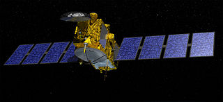
Seasat was the first Earth-orbiting satellite designed for remote sensing of the Earth's oceans and had on board the first spaceborne synthetic aperture radar (SAR). The mission was designed to demonstrate the feasibility of global satellite monitoring of oceanographic phenomena and to help determine the requirements for an operational ocean remote sensing satellite system. Specific objectives were to collect data on sea-surface winds, sea-surface temperatures, wave heights, internal waves, atmospheric water, sea ice features and ocean topography. Seasat was managed by NASA's Jet Propulsion Laboratory and was launched on 27 June 1978 into a nearly circular 800 km orbit with an inclination of 108°. Seasat operated for 106 days until 10 October 1978, when a massive short circuit in the satellite's electrical system ended the mission.

MetOp

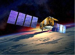
MetOp is a series of three polar orbiting meteorological satellites developed by the European Space Agency (ESA) and operated by the European Organization for the Exploitation of Meteorological Satellites (EUMETSAT). The satellites form the space segment component of the overall EUMETSAT Polar System (EPS), which in turn is the European half of the EUMETSAT/NOAA Initial Joint Polar System (IJPS). The satellites carry a payload comprising 11 scientific instruments and two which support Search and Rescue services. In order to provide data continuity between MetOp and NOAA Polar Operational Satellites (POES), several instruments are carried on both fleets of satellites.

DORIS (geodesy) system on board the European Space Agency (ESA)s Envisat satellite

Doppler Orbitography and Radiopositioning Integrated by Satellite or, in French, Détermination d'Orbite et Radiopositionnement Intégré par Satellite is a French satellite system used for the determination of satellite orbits and for positioning.

The Polar-orbiting Operational Environmental Satellite (POES) was a constellation of polar orbiting weather satellites funded by the National Oceanic and Atmospheric Administration (NOAA) and the European Organization for the Exploitation of Meteorological Satellites (EUMETSAT) with the intent of improving the accuracy and detail of weather analysis and forecasting. The Spacecraft were provided by NASA and the European Space Agency, and NASA's Goddard Space Flight Center oversaw the manufacture, integration and test of the NASA-provided TIROS satellites. The first polar-orbiting weather satellite launched as part of the POES constellation was the Television Infrared Observation Satellite (TIROS), which was launched on April 1, 1960. The final spacecraft, NOAA-19, was launched in February 2009. The ESA-provided MetOp satellite operated by EUMETSAT utilize POES-heritage instruments for the purpose of data continuity. The Joint Polar Satellite System (JPSS), which was launched on November 18, 2017, is the successor to the POES Program.

Sentinel-3 Earth observation satellite constellation

Sentinel-3 is an Earth observation satellite constellation developed by the European Space Agency as part of the Copernicus Programme.

Surface Water Ocean Topography

The Surface Water Ocean Topography (SWOT) Mission is a future satellite mission, jointly developed by NASA and CNES, the French space agency, in partnership with Canadian Space Agency (CSA) and UK Space Agency (UKSA). The objectives of the mission are to make the first global survey of the Earth's surface water and to observe the fine details of the ocean surface topography, and to measure how terrestrial surface water bodies change over time. While past satellite missions like the Jason series altimeters have provided variation in river and lake water surface elevations at select locations, SWOT will provide the first truly global observations of changing water levels in rivers, lakes and floodplains. In the world’s oceans, SWOT will also observe ocean circulation at unprecedented scales of 15–25 km, approximately an order of magnitude finer than current satellites, over the global oceans. Because it uses wide-swath altimetry technology, SWOT will almost completely observe the world's oceans and freshwater bodies with repeated high-resolution elevation measurements, allowing observations of variations.

Ocean surface topography The shape of the ocean surface relative to the geoid

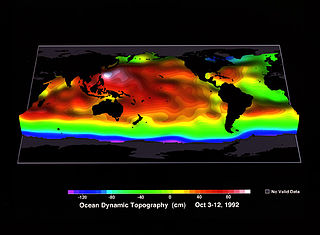
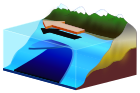
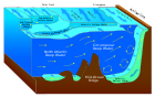
Ocean surface topography or sea surface topography, also called ocean dynamic topography, are highs and lows on the ocean surface, similar to the hills and valleys of Earth's land surface depicted on a topographic map. These variations are expressed in terms of average sea surface height (SSH) relative to the Earth's geoid. The main purpose of measuring ocean surface topography is to understand the large-scale ocean circulation.

Jason-3 International Earth observation satellite mission

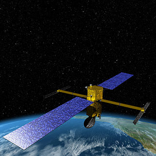
Jason-3 is a satellite created by a partnership of the European Organisation for the Exploration of Meteorological Satellites (EUMESTAT) and National Aeronautic and Space Administration (NASA), and is an international cooperative mission in which NOAA is partnering with the Centre National d'Etudes Spatiales. The satellites' mission is to supply data for scientific, commercial, and practical applications to sea level rise, sea surface temperature, ocean temperature circulation, and climate change.

SAC-D U.S-Argentinian satellite

SAC-D, also known as Aquarius after its primary instrument, is an Argentine Earth science satellite built by INVAP and operated by CONAE. SAC-D was launched from Vandenberg Air Force Base on 10 June 2011, with a planned mission life of five years. Due to a power system failure, the mission was ended on 8 June 2015.

SARAL

SARAL or Satellite with ARgos and ALtiKa is a cooperative altimetry technology mission of Indian Space Research Organisation (ISRO) and CNES. SARAL will perform altimetric measurements designed to study ocean circulation and sea surface elevation. The payloads of SARAL are The ISRO built satellite with payloads modules, DORIS, Laser Retro-reflector Array (LRA) and ARGOS-3 data collection system provided by CNES was launched by Indian Polar Satellite Launch Vehicle rocket into the Sun-synchronous orbit (SSO). ISRO is responsible for the platform, launch, and operations of the spacecraft. A CNES/ISRO MOU on the SARAL mission was signed on Feb. 23, 2007.

W. Timothy Liu became a Fellow of the American Meteorological Society in the year 2000, a Fellow of American Association for the Advancement of Science in 2007, and most recently an American Geophysical Union Fellow (2011). By the end of 2008 he had published 145 refereed journal articles or reviewed book chapters, and has authored over 260 publications in total.

The annual cycle of sea level height describes the variation of sea level that occurs with a period of one year. Historically, analysis of the annual cycle has been limited by locations with tide gauge records, i.e., coastlines and some islands in the deep ocean, and by sparse records in the Southern Hemisphere. Since 1992, satellite-based altimeters have provided near global coverage of sea level variability, allowing for a more thorough understanding of the annual cycle both in the deep ocean and in coastal margins.

Anny Cazenave is a French space geodesist and one of the pioneers in satellite altimetry. She works for the French space agency CNES and has been deputy director of the Laboratoire d'Etudes en Geophysique et Oceanographie Spatiale (LEGOS) at Observatoire Midi-Pyrénées in Toulouse since 1996. Since 2013, she is director of Earth sciences at the International Space Sciences institute (ISSI), in Bern (Switzerland).

George Henry Born was an American aerospace engineer, Distinguished Professor, founder and Director Emeritus of the Colorado Center for Astrodynamics Research (CCAR) at the University of Colorado Boulder. He is known for his work in satellite navigation and precise orbit determination. He worked on various missions while at the Jet Propulsion Laboratory as well as navigation support for the Apollo program in the late 1960s while at Johnson Space Center.

References

  1. "Ocean Surface Topography from Space". NASA/JPL.
  2. "Ocean Surface Topography from Space". NASA/JPL. Archived from the original on 2008-05-31.
  3. "Ocean Surface Topography from Space". NASA/JPL. Archived from the original on 2008-05-13.
  4. "NASA Launches Ocean Satellite to Keep a Weather, Climate Eye Open". NASA.
  5. "Jason-2 successfully launched". EUMETSAT. Archived from the original on 2008-11-16.
  6. "Tandem Mission Brings Ocean Currents into Sharper Focus". NASA/JPL. Archived from the original on 2009-04-22.
  7. "NOAA takes over Jason-2 satellite operations". EUMETSAT. Archived from the original on 2011-06-15.
  8. "T2L2 ready to put Einstein's theory to the test". CNES. 6 November 2008.
  9. "(OSTM) - Jason 2 Overview". NOAA. Archived from the original on 2007-06-14.
  10. "New Oceanography Mission Data Now Available". NASA/JPL.
  11. "OSTM/JASON-2 SCIENCE AND OPERATIONAL REQUIREMENTS". EUMETSAT. Archived from the original on 2007-09-28.
  12. "The Legacy of Topex/Poseidon and Jason 1, page 30. Ocean Surface Topography Mission/Jason 2 Launch Press Kit, June 2008" (PDF). NASA/JPL.
  13. "Jason-3 Missions Summary" Jet Propulsion Laboratory. Retrieved 25 May 2014.
  14. "Jason-3 Quick Facts" National Environmental Satellite Data and Information Service. Retrieved 11 June 2015.
  15. Clark, Stephen (2015-06-18). "Jason 3 satellite shipped to Vandenberg for SpaceX launch | Spaceflight Now". Spaceflight Now. Spaceflight Now Inc. Retrieved 2015-06-22.
  16. @NOAASatellites (11 December 2015). "Launch date for Jason-3 announced! Launch scheduled for Jan 17, 2016 at 10:42:18am PST" (Tweet) via Twitter.
  17. "Jason-3 January 17, 2016 Launch Date Announced". NOAA Satellite and Information Service. 8 January 2016. Retrieved 15 January 2016.

Commons-logo.svg Media related to Ocean Surface Topography Mission at Wikimedia Commons