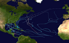
Hurricane Epsilon (2020)

Last updated

Map key
  Tropical depression (≤38 mph, ≤62 km/h)
  Tropical storm (39–73 mph, 63–118 km/h)
  Category 1 (74–95 mph, 119–153 km/h)
  Category 2 (96–110 mph, 154–177 km/h)
  Category 3 (111–129 mph, 178–208 km/h)
  Category 4 (130–156 mph, 209–251 km/h)
  Category 5 (≥157 mph, ≥252 km/h)
  Unknown
Storm type
Disc Plain black.svg Tropical cyclone
Solid black.svg Subtropical cyclone
ArrowUp.svg Extratropical cyclone, remnant low, tropical disturbance, or monsoon depression

Hurricane Epsilon had non-tropical origins, developing from an upper-level trough associated with a weak baroclinic low that emerged off the East Coast of the United States on October 13. As the primary low continued to drift towards the northeast, a trailing cold front behind the low moved eastward into the central Atlantic Ocean over the next few days; the low eventually stalled on October 15 and soon degenerated into a surface trough well east of Bermuda. [4] Around this time, the National Hurricane Center (NHC) first noted the possibility of a broad non-tropical low-pressure system forming within the trough several days later, identifying a chance that the disturbance could gradually organize and undergo tropical cyclogenesis. [5] Upstream synoptic flow began to increase, as an expansive upper-level ridge developed across the northwestern Atlantic, west of the original upper-level trough. This meteorological pattern caused the upper-level trough to be cut off, while bending underneath the ridge. On October 16, convective activity (or thunderstorms) began to increase and become better organized, as the cut-off low interacted with the degrading parent trough. [4] [6] With the low-level cyclonic flow strengthening, a non-tropical surface low formed underneath the cut-off upper-level low, at 12:00 UTC that same day. [4]

Later that day, satellite wind data depicted a better-defined circulation, while convective activity continued to organize within the upper-level low. [7] Over the next few days, the surface low continued to remain superimposed underneath the upper-level low, as it slowly wandered southward, equatorward of a deep-layer ridge resembling an omega block in the northern Atlantic. Only minimal convection was produced by the surface low, due to dry air associated with upper-level low prohibiting much convective activity. While moving southward, the disturbance encountered warmer sea surface temperatures of around 80 °F (27 °C), causing convection to flourish and deepen. [4] However, the disturbance's center of circulation remained somewhat elongated. [8] The convective activity began to degrade the dry cyclonic flow of the upper-level low, aiding the tropical transition of the system, as its wind field contracted and upper-level cyclonic flow intensified. At 06:00 UTC on October 19, a large burst of deep convection developed just east of the surface low, causing the center to become more sufficiently organized, prompting the NHC to upgrade the disturbance into Tropical Depression Twenty-Seven. The NHC also noted that the depression appeared more tropical than subtropical, due to its small radius of maximum sustained winds, despite undergoing a similar formation process to that of subtropical cyclones. [4] [9]

The Air Force Reserve Hurricane Hunters inside the stadium-effect eye of Hurricane Epsilon on October 21 Hurricane Hunters Inside Epsilon 2020.jpg
The Air Force Reserve Hurricane Hunters inside the stadium-effect eye of Hurricane Epsilon on October 21

Just six hours later, the depression strengthened into a tropical storm, and was given the name Epsilon. [4] The name Epsilon comes from the Greek Alphabet backup naming lists for the NHC, which was only used for two seasons, the other being the 2005 season. [10] Despite the center of the storm becoming exposed, convective banding over the northern and eastern parts of the system improved. This made the system take on the appearance of having a hybrid-type structure, resembling a subtropical cyclone in appearance. Situated within an area of moderate vertical wind shear and warm sea surface temperatures, further strengthening occurred. Later that same day, a new convective cluster near the center returned Epsilon to a more tropical appearance. However, ASCAT data depicted an asymmetrical wind radius, with gale-force winds extending northward 230 miles (370 km) from the center. [11] [12] Early on October 20, water vapor imagery showed Epsilon interacting with a dissipating cold front to its north and a negatively-titled (oriented northwest to southeast) upper-level trough from the south. Around this time, a dry slot formed within the eastern portion of the storm, weakening convective banding. The cloud pattern of Epsilon began to resemble an occluded extratropical low, with an inner-core tropical feature evident. [13] The system began to move northward and then northwestward, making a loop over the Central Atlantic, due to its smaller circulation interacting with its upper-level cyclonic flow. [4] Later that day, the system began to be affected by southwesterly vertical wind shear, due to the upper-level trough to its southwest, though it retained its hybrid-type structure. [14] However, late that same day, wind shear calmed and dry air was mixed out of the cyclone, allowing the cyclone's structure to improve, with deep convection wrapping tightly around the center, as a small central dense overcast (CDO) became visible on satellite imagery. Even while battling weak-to-moderate deep-layer wind shear and some mid-level dry air, an eye-like feature started to become evident on visible and microwave imagery, giving Epsilon a more tropical structure, compared to its earlier hybrid appearance. [15] Around this time, Epsilon underwent a period of rapid intensification, with sustained winds increasing by 50 mph (80 km/h) within a 24-hour period. [4] At 03:00 UTC the next day, the NHC upgraded the strengthening tropical storm to a Category 1 hurricane, while it was located roughly 545 miles (877 km) east-southeast of Bermuda. [16] However, the eastern and southern sides of the eyewall were rather thin, even as Epsilon shifted west-northwestward, due to a mid-tropospheric ridge located north of the cyclone. [17] Despite this, just a few hours later, microwave imagery showed a closed eyewall with deep convection enclosing the center, with a 15 miles (24 km) eye visible. Around this time, Epsilon briefly shifted westward, before returning to its previous northwestward movement. [18] At 18:00 UTC that same day, the Air Force Reserve Hurricane Hunters investigated the cyclone, finding flight-level and surface winds of around 110 mph (180 km/h), marking the storm's intensification into a high-end Category 2 hurricane. The reconnaissance aircraft also discovered a stadium-effect eye. [19] [20]

Epsilon as a weakening tropical storm south of Atlantic Canada on October 25 Epsilon 2020-10-25 1800Z.png
Epsilon as a weakening tropical storm south of Atlantic Canada on October 25

Just three hours later, Epsilon reached Category 3 major hurricane status, while displaying a well-organized satellite presentation. A warm, well-defined eye was evident, with closed eyewall convection, and cloud top temperatures of around −76 °F (−60 °C). [21] The upgrade to a Category 3 hurricane made Epsilon the easternmost major hurricane recorded this late in the calendar year, as well as the strongest late-season major hurricane in the northeastern Atlantic, and the fastest rapid intensification rate of a tropical cyclone recorded this far northeast this late in the Atlantic hurricane season. [2] At 00:00 UTC on October 22, Epsilon reached its peak intensity, with 1-minute sustained winds of around 115 mph (185 km/h) and a minimum central pressure of around 952 mbar (28.11 inHg). Meanwhile, the hurricane's small and well-defined inner core was located within an environment of deep-level moisture, protecting it from dry air associated with an upper-level trough wrapping three-quarters of the way around the hurricane. [4] Shortly afterward, Epsilon began to degrade due to a dry air intrusion, and its eye started to become ill-defined and cloud-filled, while its western eyewall eroded, causing the storm to weaken to a Category 2 hurricane. [22] Weakening ensued throughout the day, further degrading Epsilon to a 85 mph (135 km/h)-Category 1 hurricane before the weakening trend stopped, with the storm maintaining this intensity for about 48 hours. However, the eye briefly became better-defined, before becoming ill-defined once more just a few hours later. Meanwhile, the CDO became disorganized, with a broad outer band wrapping around the western portion of the storm. However, upper-level outflow was well-defined in the northern part of the hurricane. [23] [24] [4] Around this time, Epsilon made its closest approach to Bermuda, passing just 190 miles (310 km) east of the island. [25] At 15:00 UTC on October 23, a small eye reappeared on geostationary and polar-orbiting microwave imagery, along with increased well-defined curved banding. [26] Concentric eyewalls began to develop within Epsilon, while the northern half of its wind field expanded, indicating the start of an eyewall replacement cycle. [27] Several hours later, early on October 24, Epsilon completed its eyewall replacement cycle. The storm's convective pattern devolved into a large, comma-shaped structure, rather than the classical circular structure normally seen in mature tropical cyclones. [28] During this time, Epsilon moved over the warm waters of the Gulf Stream, which allowed it to retain its intensity. A buoy near the center of the hurricane indicated that Epsilon's central pressure was about 957.8 millibars (28.28 inHg) around this time, which indicated that Epsilon was a stronger hurricane than the NHC had estimated it to be earlier. [29]

Later that day, Epsilon began interacting with another upper-level trough; combined with baroclinic forcing, this caused Epsilon's wind field and inner core to expand in size. Epsilon also turned sharply northeastward and accelerated its forward motion. [4] The hurricane slowly weakened as it continued moving further north. Early on October 25, Epsilon began transitioning into an extratropical cyclone, with the storm's cloud pattern expanding in size. [30] The storm soon moved north of the Gulf Stream several hours later and entered much cooler waters, [30] [31] subsequently weakening into a tropical storm at about 18:00 UTC on the same day, even as it moved closer to another larger extratropical storm to the north, which was spawned by the upper-level trough. [32] [4] At 06:00 UTC on October 26, Epsilon finished transitioning into an extratropical cyclone while located about 565 miles (909 km) east of Cape Race, Newfoundland, with the storm's low-level circulation becoming stretched out along a north–south axis. [4] [33] Later that day, Epsilon was absorbed by the larger extratropical storm to the north, at 18:00 UTC. [4]

Preparations and impact

Bermuda

Epsilon as a weakening Category 1 hurricane on October 23, with Bermuda visible just southwest of the storm Epsilon 2020-10-23 1705Z.jpg
Epsilon as a weakening Category 1 hurricane on October 23, with Bermuda visible just southwest of the storm

Epsilon's large wind field prompted the issuance of a tropical storm watch for Bermuda at 15:00 UTC on October 20, [34] which was later upgraded to a warning 24 hours later. [35] As the hurricane began moving away from Bermuda on October 23, the tropical storm warning was cancelled. [36] Despite the Bermuda Weather Service not forecasting hurricane-force winds to impact the island, the Government of Bermuda advised residents to prepare for power outages and to check their emergency supplies. Though no transportation disruptions were anticipated, bikers were warned to be cautious of strong wind gusts. [37] [38] Dangerous Surf Advisories were posted on southern-facing beaches, with residents urged to stay out of the water. [39] The start of the World Tens Series had to be postponed from October 24 to the following day, to avoid severe weather from Epsilon. [40]

Between October 22–23, Epsilon passed just 190 miles (310 km) east of Bermuda. Several locations of the island reported tropical storm-force winds, owing to the hurricane's large wind field. Sustained winds peaked at about 49 mph (79 km/h), with the highest wind gust measured at 60 mph (97 km/h), which was recorded at the Maritime Operations Centre, at an elevation of about 290 feet (88,000 mm). Tropical storm-force winds were also reported on Pearl Island and The Crescent, while a wind gust of 38 mph (61 km/h) was registered at the L.F. Wade International Airport. [4] [25] Only minor wind damage occurred on the island, while most weak trees and tree branches had already been downed by previous Hurricanes Paulette and Teddy. [41] [4] The outer bands of the storm only brought scattered showers to Bermuda, with a peak precipitation amount of 0.42 inches (11 mm) being reported at the L.F. Wade International Airport. [4] Epsilon produced dangerous swells along the coast of Bermuda, forcing lifeguards at Horseshoe Bay to briefly halt services. [42] In St. George's, video taken by Bernews showed waves crashing over small seawalls. Photos also showed waves ponding on nearby sidewalks and roads. Overall, damage in Bermuda was minor, and the storm's impact was compared to that of winter gales on the island. [37] [43] [44]

United States and British Isles

A rip current risk forecast for the coast of North Carolina on October 22, produced by the National Weather Service, as a result of Hurricane Epsilon Epsilonripcurrentrisk2020.png
A rip current risk forecast for the coast of North Carolina on October 22, produced by the National Weather Service, as a result of Hurricane Epsilon

Epsilon produced large swells and rip currents from the Virgin Islands and Puerto Rico, northward through the entire East Coast of the United States. [45] On the island of Puerto Rico, coastal flood and rip current advisories were issued by the National Weather Service (NWS) office in San Juan. Large waves were reported in Veja Baja, as shown by video posted on Twitter. [46] High surf also affected the neighboring Virgin Islands. [47] In Daytona Beach, Florida, a direct death occurred when a 27-year-old man drowned in rip currents produced by Epsilon. [4] In North Carolina, an offshore buoy near Diamond Shoals reported an increase in wave size from 5 to 12 feet (1.5 to 3.7 m) overnight between October 22–23. Along the coast of North Carolina, rip current warnings were posted from the Outer Banks to as far south as North Topsail Beach. [48] Increased swells and rip currents also threatened swimmers in South Carolina, causing red flags to be raised in Myrtle Beach. [49] Long-period swells that reached heights of 5–8 feet (1.5–2.4 m) affected the coasts of New Jersey, Long Island, and New York City. [50] Life-threatening swells and rip currents also impacted the coast of New England. [51]

The remnants of Epsilon, along with a tailing occluded front, brought severe weather to the British Isles. [52] In advance, Met Éireann issued a yellow rainfall warning for the counties of Galway and Mayo. Meanwhile, yellow wind warnings were ordered for Clare, Donegal, Galway, Kerry, and Mayo Counties. Another yellow wind warning was placed in effect for Wexford, Cork, and Waterford. [53] The Met Office also issued yellow warnings for parts of Wales and North West England. [54] Yellow rain warnings were also issued for parts of North West England, with the storm causing disruptions to train and bus services, and threatening flooding. [55] In Ireland, the remnants of Epsilon caused outbreaks of rainfall and blustery conditions. [56] In Northern Ireland, large swells of up to 98 feet (30 m) in height were recorded by offshore buoys, sending skilled surfers to beaches, as spectators watched waves crash onshore. [57] In the mainland United Kingdom, torrential rainfall and gusty winds of up to 70 mph (110 km/h) affected the region. [58] Professional surfers were seen braving 20-foot (6.1-meter) waves in Cornwall. Meanwhile, the Royal National Lifeboat Institution (RNLI) warned residents of "colossal swells" and "extremely dangerous conditions", advising people to avoid swimming in the ocean. [59]

Elsewhere

Rough surf from Hurricane Epsilon impacted the Leeward Islands, Greater Antilles, and the Lucayan Archipelago. [60] While weakening, Epsilon brought swells of up to 23 feet (7.0 m) to the coast of Atlantic Canada. Moisture from the storm, along with a cold front, also brought gusty winds and rainfall to the region. Wind gusts up to 37 mph (60 km/h) impacted the Avalon Peninsula during the evening of October 24, where rainfall totals of up to 1.9 inches (48 mm) were recorded. [61] In Portugal, the remnants of Epsilon produced one of the largest October swells on record in Nazaré. [3]

Naming

The 2020 season was the second (along with 2005) in which an alphabetic list of 21 storm names had been exhausted, necessitating use of the Greek alphabet auxiliary list. In March 2021, the World Meteorological Organization replaced that auxiliary list with a new 21-name supplemental list. As a result, the letter Epsilon will not be used to name another Atlantic hurricane. [62]

See also

Notes

  1. A major hurricane is one that ranks at Category 3 or higher on the Saffir–Simpson scale. [1]
  2. All winds are one-minute sustained unless otherwise noted.

Related Research Articles

<span class="mw-page-title-main">1992 Atlantic hurricane season</span> Hurricane season in the Atlantic Ocean

The 1992 Atlantic hurricane season was a significantly below average season for overall tropical or subtropical cyclones as only ten formed. Six of them became named tropical storms, and four of those became hurricanes; one hurricane became a major hurricane. The season was also near-average in terms of accumulated cyclone energy. The season officially started on June 1 and officially ended on November 30. However, tropical cyclogenesis is possible at any time of the year, as demonstrated by formation in April of an unnamed subtropical storm in the central Atlantic.

<span class="mw-page-title-main">Tropical Storm Ana (2003)</span> Atlantic tropical storm

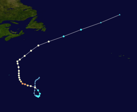
Tropical Storm Ana was the first named storm of the 2003 Atlantic hurricane season. A pre-season storm, it developed initially as a subtropical cyclone from a non-tropical low on April 20 to the west of Bermuda. It tracked east-southeastward and organized, and on April 21 it transitioned into a tropical cyclone with peak winds of 60 mph (97 km/h). Tropical Storm Ana turned east-northeastward, steadily weakening due to wind shear and an approaching cold front, and on April 24 it became an extratropical cyclone. The storm brushed Bermuda with light rain, and its remnants produced precipitation in the Azores and the United Kingdom. Swells generated by the storm capsized a boat along the Florida coastline, causing two fatalities.

<span class="mw-page-title-main">Tropical Storm Zeta (2005)</span> Off season Atlantic tropical cyclone

Tropical Storm Zeta was a very late-developing tropical storm that formed in the central Atlantic Ocean during the 2005 Atlantic hurricane season, one month after the season's official end. Becoming a tropical depression on December 30, and intensifying the following day into the season's 28th storm, Zeta continued into January 2006. It was one of only two Atlantic tropical cyclones to span two calendar years.

<span class="mw-page-title-main">Subtropical Storm Nicole</span> Atlantic subtropical storm in 2004

Subtropical Storm Nicole was the first subtropical storm to receive a name using the standard hurricane name list that did not become a tropical cyclone. The fifteenth tropical or subtropical cyclone and fourteenth named storm of the 2004 Atlantic hurricane season, Nicole developed on October 10 near Bermuda from a broad surface low that developed as a result of the interaction between an upper level trough and a decaying cold front. The storm turned to the northeast, passing close to Bermuda as it intensified to reach peak winds of 50 mph (80 km/h) on October 11. Deep convection developed near the center of the system as it attempted to become a fully tropical cyclone. However, it failed to do so and was absorbed by an extratropical cyclone late on October 11.

<span class="mw-page-title-main">Hurricane Kyle (2002)</span> Category 1 Atlantic hurricane in 2002

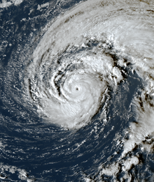
Hurricane Kyle was the fifth-longest-lived Atlantic tropical or subtropical cyclone on record. The eleventh named storm and third hurricane of the 2002 Atlantic hurricane season, Kyle developed as a subtropical cyclone on September 20 to the east-southeast of Bermuda. Looping westward, it transitioned into a tropical cyclone and became a hurricane on September 25. For the next two weeks, Kyle tracked generally westward, oscillating in strength several times because of fluctuations in environmental conditions. On October 11, the cyclone turned northeastward and made landfalls near Charleston, South Carolina, and Long Beach, North Carolina, at tropical storm status. After lasting as a cyclone for 22 days, Kyle dissipated on October 12 as it was absorbed by an approaching cold front.

<span class="mw-page-title-main">Hurricane Erin (2001)</span> Category 3 Atlantic hurricane

Hurricane Erin was the longest-lived hurricane in the 2001 Atlantic hurricane season. The sixth tropical depression, fifth tropical storm, and first hurricane of the season, Erin developed from a tropical wave on September 1. After strengthening to a 60 mph (97 km/h) tropical storm as it moved to the west-northwest, wind shear weakened Erin and caused it to degenerate into a remnant low on September 5. The remnants re-organized into a tropical depression the next day, and Erin strengthened into a hurricane on September 9 while moving northwestward. This was the latest date for the first hurricane of the season since Hurricane Diana on September 10, 1984. Erin quickly intensified and reached peak winds of 120 mph (190 km/h) later on September 9. At its closest approach, Erin passed 105 miles (169 km) east-northeast of Bermuda near peak intensity, and subsequently weakened as it turned to the east. A trough turned Erin to the northeast, and after passing just east of Cape Race, Newfoundland it became extratropical on September 15. The extratropical remnant continued northeastward and was absorbed into another extratropical storm near Greenland on September 17.

<span class="mw-page-title-main">Hurricane Bertha (2008)</span> Category 3 Atlantic hurricane in 2008

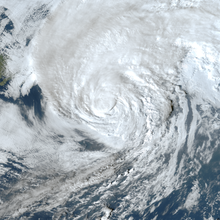
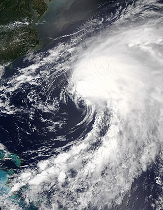
Hurricane Bertha was the longest-lived Atlantic tropical cyclone on record during July, as well as the furthest east system to attain tropical storm intensity during the month. The second named storm, first hurricane, and first major hurricane of the active 2008 season, Bertha developed into a tropical depression on July 3 from a tropical wave that departed western Africa two days prior. On a west-northwest to northwest track, the depression intensified into Tropical Storm Bertha six hours formation and ultimately attained hurricane intensity on July 7. A period of rapid deepening brought the cyclone to its peak as a Category 3 hurricane with winds of 125 mph (205 km/h) late that afternoon. Changes in wind shear and the storm's internal structure allowed Bertha to fluctuate in intensity over the next week as it passed very near Bermuda, but a track over cooler waters eventually caused the system to become an extratropical cyclone by July 20. It continued northeast and was absorbed by another low near Iceland the following day. Rough surf propelled by Bertha killed three people along the East Coast of the United States; hundreds of other swimmers were injured and/or required rescuing. In Bermuda, some streets were flooded and strong gusts cut power to approximately 7,500 homes; only minor damage was observed.

<span class="mw-page-title-main">2012 Atlantic hurricane season</span> Hurricane season in the Atlantic Ocean

The 2012 Atlantic hurricane season was the final year in a string of three consecutive very active seasons since 2010, with 19 tropical storms. The 2012 season was also a costly one in terms of property damage, mostly due to Hurricane Sandy. The season officially began on June 1 and ended on November 30, dates that conventionally delimit the period during each year in which most tropical cyclones form in the Atlantic Ocean. However, Alberto, the first named system of the year, developed on May 19 – the earliest date of formation since Subtropical Storm Andrea in 2007. A second tropical cyclone, Beryl, developed later that month. This was the first occurrence of two pre-season named storms in the Atlantic basin since 1951. It moved ashore in North Florida on May 29 with winds of 65 mph (105 km/h), making it the strongest pre-season storm to make landfall in the Atlantic basin. This season marked the first time since 2009 where no tropical cyclones formed in July. Another record was set by Hurricane Nadine later in the season; the system became the fourth-longest-lived tropical cyclone ever recorded in the Atlantic, with a total duration of 22.25 days. The final storm to form, Tony, dissipated on October 25 – however, Hurricane Sandy, which formed before Tony, became extratropical on October 29.

<span class="mw-page-title-main">2014 Atlantic hurricane season</span> Hurricane season in the Atlantic Ocean

The 2014 Atlantic hurricane season was a below-average hurricane season in terms of named storms and major hurricanes, though average in terms of number of hurricanes overall. It produced nine tropical cyclones, eight of which became named storms; six storms became hurricanes and two intensified further into major hurricanes. The season officially began on June 1, and ended on November 30. These dates historically describe the period each year when most tropical cyclones form in the Atlantic basin. The first storm of the season, Arthur, developed on July 1, while the final storm, Hanna, dissipated on October 28, about a month prior to the end of the season.

<span class="mw-page-title-main">Hurricane Epsilon (2005)</span> Category 1 Atlantic hurricane in 2005

Hurricane Epsilon was the twenty-seventh named tropical or subtropical storm and the final of 15 hurricanes in the record-breaking 2005 Atlantic hurricane season. Originating from a cold front beneath an upper-level low, Epsilon formed on November 29 about 915 mi (1470 km) east of Bermuda, becoming the second tropical storm to do so in that area of the Atlantic within the span of a week. Initially, the National Hurricane Center (NHC) forecast the storm to transition into an extratropical cyclone within five days, due to conditions unfavorable for significant intensification. Epsilon continually defied forecasts, at first due to an unexpected loop to the southwest, and later due to retaining its strength despite cold waters and strong wind shear.

<span class="mw-page-title-main">Hurricane Nadine</span> Category 1 Atlantic hurricane in 2012

Hurricane Nadine was an erratic Category 1 hurricane that became the fourth-longest-lived Atlantic hurricane on record. As the fourteenth tropical cyclone and named storm of the 2012 Atlantic hurricane season, Nadine developed from a tropical wave traveling west of Cape Verde on September 10. On the following day, it had strengthened into Tropical Storm Nadine. After initially tracking northwestward, Nadine turned northward, well away from any landmass. Early on September 15, Nadine reached hurricane status as it was curving eastward. Soon after, an increase in vertical wind shear weakened Nadine and by September 16 it was back to a tropical storm. On the following day, the storm began moving northeastward and threatened the Azores but late on September 19, Nadine veered east-southeastward before reaching the islands. Nonetheless, the storm produced tropical storm force winds on a few islands. On September 21, the storm curved south-southeastward while south of the Azores. Later that day, Nadine transitioned into a extratropical low pressure area.

<span class="mw-page-title-main">2019 Atlantic hurricane season</span> Hurricane season in the Atlantic Ocean

The 2019 Atlantic hurricane season was the fourth consecutive above-average and damaging season dating back to 2016. However, many storms were weak and short-lived, especially towards the end of the season. Six of those named storms achieved hurricane status, while three intensified into major hurricanes. Two storms became Category 5 hurricanes, marking the fourth consecutive season with at least one Category 5 hurricane, the third consecutive season to feature at least one storm making landfall at Category 5 intensity, and the seventh on record to have multiple tropical cyclones reaching Category 5 strength. The season officially began on June 1 and ended on November 30. These dates historically describe the period each year when most tropical cyclones form in the Atlantic basin and are adopted by convention. However, tropical cyclogenesis is possible at any time of the year, as demonstrated by the formation of Subtropical Storm Andrea on May 20, making this the fifth consecutive year in which a tropical or subtropical cyclone developed outside of the official season.

<span class="mw-page-title-main">2020 Atlantic hurricane season</span> Hurricane season in the Atlantic Ocean

The 2020 Atlantic hurricane season was the most active Atlantic hurricane season on record, in terms of number of systems. It featured a total of 31 tropical or subtropical cyclones, with all but one cyclone becoming a named storm. Of the 30 named storms, 14 developed into hurricanes, and a record-tying seven further intensified into major hurricanes. It was the second and final season to use the Greek letter storm naming system, the first being 2005, the previous record. Of the 30 named storms, 11 of them made landfall in the contiguous United States, breaking the record of nine set in 1916. During the season, 27 tropical storms established a new record for earliest formation date by storm number. This season also featured a record ten tropical cyclones that underwent rapid intensification, tying it with 1995, as well as tying the record for most Category 4 hurricanes in a singular season in the Atlantic Basin. This unprecedented activity was fueled by a La Niña that developed in the summer months of 2020, continuing a stretch of above-average seasonal activity that began in 2016. Despite the record-high activity, this was the first season since 2015 in which no Category 5 hurricanes formed.

<span class="mw-page-title-main">2021 Atlantic hurricane season</span> Hurricane season in the Atlantic Ocean

The 2021 Atlantic hurricane season was the third-most active Atlantic hurricane season on record in terms of number of tropical cyclones, although many of them were weak and short-lived. With 21 named storms forming, it became the second season in a row and third overall in which the designated 21-name list of storm names was exhausted. Seven of those storms strengthened into a hurricane, four of which reached major hurricane intensity, which is slightly above-average. The season officially began on June 1 and ended on November 30. These dates historically describe the period in each year when most Atlantic tropical cyclones form. However, subtropical or tropical cyclogenesis is possible at any time of the year, as demonstrated by the development of Tropical Storm Ana on May 22, making this the seventh consecutive year in which a storm developed outside of the official season.

<span class="mw-page-title-main">2021 Pacific hurricane season</span> Hurricane season in the Pacific Ocean

The 2021 Pacific hurricane season was a moderately active Pacific hurricane season, with above-average activity in terms of number of named storms, but below-average activity in terms of major hurricanes, as 19 named storms, 8 hurricanes, and 2 major hurricanes formed in all. It also had a near-normal accumulated cyclone energy (ACE). The season officially began on May 15, 2021 in the Eastern Pacific Ocean, and on June 1, 2021, in the Central Pacific in the Northern Hemisphere. The season ended in both regions on November 30, 2021. These dates historically describe the period each year when most tropical cyclogenesis occurs in these regions of the Pacific and are adopted by convention. However, the formation of tropical cyclones is possible at any time of the year, as illustrated by the formation of Tropical Storm Andres on May 9, which was the earliest forming tropical storm on record in the Eastern Pacific. Conversely, 2021 was the second consecutive season in which no tropical cyclones formed in the Central Pacific.

<span class="mw-page-title-main">Tropical Storm Arthur (2020)</span> Atlantic tropical storm in 2020

Tropical Storm Arthur was a strong off-season tropical cyclone that impacted the East Coast of the United States in May 2020. The first of thirty-one depressions and thirty different named storms of the extremely active 2020 Atlantic hurricane season, Arthur marked the record sixth consecutive year in the Atlantic basin with a tropical cyclone forming before June. It was one of two off-season storms in the season, alongside short-lived Tropical Storm Bertha. Arthur originated from a front that stalled over the Straits of Florida on May 10, which slowly drifted south for two days. The system became a tropical depression on May 16 north of The Bahamas. A day later, the system intensified into a tropical storm and was named Arthur. Arthur gradually intensified while tracking towards the Outer Banks of North Carolina, attaining its peak intensity with maximum 1-minute sustained winds of 60 mph (97 km/h) and a minimum central pressure of 990 mbar (29 inHg) on May 19, before skirting the region and becoming an extratropical cyclone. The cyclone then accelerated towards Bermuda and dissipated on May 21.

<span class="mw-page-title-main">Hurricane Paulette</span> Category 2 Atlantic hurricane in 2020

Hurricane Paulette was a strong and long-lived Category 2 Atlantic hurricane which became the first to make landfall in Bermuda since Hurricane Gonzalo did so in 2014. The sixteenth named storm and sixth hurricane of the record-breaking 2020 Atlantic hurricane season, Paulette developed from a tropical wave that left the coast of Africa on September 2. The wave eventually consolidated into a tropical depression on September 7. Paulette fluctuated in intensity over the next few days, due to strong wind shear, initially peaking as a strong tropical storm on September 8. It eventually strengthened into a hurricane early on September 13 as shear decreased. On September 14, Paulette made landfall in northeastern Bermuda as a Category 2 hurricane, while making a gradual turn to the northeast. The cyclone further strengthened as it moved away from the island, reaching its peak intensity with 1-minute sustained winds of 105 mph (169 km/h) and a minimum central atmospheric pressure of 965 mbar (28.5 inHg) on September 14. On the evening of September 15, Paulette began to weaken and undergo extratropical transition, which it completed on September 16. The hurricane's extratropical remnants persisted and moved southward then eastward, and eventually, Paulette regenerated into a tropical storm early on September 20 south of the Azores– which resulted in the U.S National Weather Service coining the phrase "zombie storm" to describe its unusual regeneration. Paulette's second phase proved short-lived, however, as the storm quickly weakened and became post-tropical again two days later. The remnant persisted for several days before dissipating south of the Azores on September 28. In total, Paulette was a tropical cyclone for 11.25 days, and the system had an overall lifespan of 21 days.

<span class="mw-page-title-main">Hurricane Teddy</span> Category 4 Atlantic hurricane in 2020

Hurricane Teddy was a large and powerful Cape Verde hurricane that was the fifth-largest Atlantic hurricane by diameter of gale-force winds recorded. Teddy produced large swells along the coast of the Eastern United States and Atlantic Canada in September 2020. The twentieth tropical depression, nineteenth named storm, eighth hurricane, and second major hurricane of the record-breaking 2020 Atlantic hurricane season, Teddy initially formed from a tropical depression that developed from a tropical wave on September 12. Initially, the depression's large size and moderate wind shear kept it from organizing, but it eventually intensified into Tropical Storm Teddy on September 14. After steadily intensifying for about a day, the storm rapidly became a Category 2 hurricane on September 16 before westerly wind shear caused a temporary pause in the intensification trend. It then rapidly intensified again on September 17 and became a Category 4 hurricane. Internal fluctuations and eyewall replacement cycles then caused the storm to fluctuate in intensity before it weakened some as it approached Bermuda. After passing east of the island as a Category 1 hurricane on September 21, Teddy restrengthened back to Category 2 strength due to baroclinic forcing. It weakened again to Category 1 strength the next day before becoming post-tropical as it approached Atlantic Canada early on September 23. It then weakened to a gale-force low and made landfall in Nova Scotia with sustained winds of 65 mph (105 km/h). The system weakened further as it moved northward across eastern Nova Scotia and then the Gulf of St. Lawrence, before being absorbed by a larger non-tropical low early on September 24, near eastern Labrador.

<span class="mw-page-title-main">Hurricane Chris (2018)</span> Category 2 Atlantic hurricane in 2018

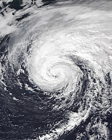
Hurricane Chris was a moderately strong tropical cyclone that affected the East Coast of the United States and Atlantic Canada in July 2018. The third tropical or subtropical cyclone, third named storm, and second hurricane of the 2018 Atlantic hurricane season, Chris originated from a frontal system that moved offshore the coast of the northeastern United States on June 29. The front evolved into a non-tropical low by July 3. After further organization, a tropical depression formed on July 6, several hundred miles south-southeast of Cape Hatteras, North Carolina. Two days later, the depression strengthened into a tropical storm and received the name Chris. Chris slowly strengthened as it drifted into warmer waters. These favorable conditions allowed Chris to rapidly intensify into a hurricane on July 10. The hurricane reached its peak intensity with winds of 105 mph (165 km/h) and a pressure of 969 mbar (28.61 inHg) at. This peak intensity was short-lived though, as Chris began to undergo extratropical transition. At 12:00 UTC on July 12, Chris became an extratropical cyclone well southeast of Newfoundland. The low continued northeastward over the Atlantic for the next few days, before weakening and finally dissipating southeast of Iceland on July 17.

<span class="mw-page-title-main">Tropical Storm Alex (2022)</span> Atlantic tropical storm in 2022

Tropical Storm Alex was a strong tropical cyclone that caused flash flooding in western Cuba and South Florida while developing into the first named storm of the 2022 Atlantic hurricane season. Alex originated from a broad area of low pressure partially related to the remnants of Hurricane Agatha in the Eastern Pacific. The National Hurricane Center (NHC) initiated advisories on it as Potential Tropical Cyclone One over the eastern Yucatán Peninsula on June 2. Wind shear and dry air kept the system disorganized until after it crossed Florida two days later. Finally, on June 5, the system became sufficiently organized and was named Alex while located north of Grand Bahama Island. Later that same day, Alex's winds briefly strengthened to 70 mph (110 km/h). The storm brought rain and strong winds to Bermuda on June 6, before becoming a post-tropical cyclone that same day. Alex formed four days after the official start of the season, making the 2022 Atlantic hurricane season the first since 2014 not to have a pre-season named storm.

References

  1. "Saffir-Simpson Hurricane Wind Scale". National Hurricane Center. Archived from the original on June 20, 2020. Retrieved June 22, 2020.
  2. 1 2 Matthew Cappucci (October 21, 2020). "Hurricane Epsilon shatters records as it rapidly intensifies near Bermuda". The Washington Post. Archived from the original on December 10, 2020. Retrieved May 5, 2021.
  3. 1 2 "Hurricane Epsilon generates huge swell in the Atlantic, giant waves off coast of Portugal". The Portugal News. October 30, 2020. Archived from the original on May 8, 2021. Retrieved May 8, 2021.
  4. 1 2 3 4 5 6 7 8 9 10 11 12 13 14 15 16 17 18 Phillipe P. Pappin (April 9, 2021). Tropical Cyclone Report: Hurricane Epsilon (PDF) (Report). Miami, Florida: National Hurricane Center. Archived (PDF) from the original on April 12, 2021. Retrieved April 12, 2021.PD-icon.svg This article incorporates text from this source, which is in the public domain .
  5. Stacy Stewart (October 15, 2020). Five-Day Graphical Tropical Weather Outlook (Report). Miami, Florida: National Hurricane Center. Archived from the original on April 1, 2021. Retrieved April 29, 2021.
  6. Jack Beven (October 16, 2020). Two-Day Graphical Tropical Weather Outlook (Report). Miami, Florida: National Hurricane Center. Archived from the original on May 2, 2021. Retrieved May 2, 2021.
  7. Jack Beven (October 16, 2020). Two-Day Graphical Tropical Weather Outlook (Report). Miami, Florida: National Hurricane Center. Archived from the original on May 2, 2021. Retrieved May 2, 2021.
  8. John Cangialosi (October 17, 2020). Two-Day Graphical Tropical Weather Outlook (Report). Miami, Florida: National Hurricane Center. Archived from the original on May 2, 2021. Retrieved May 2, 2021.
  9. Daniel Brown (October 19, 2020). Tropical Depression Twenty-Seven Special Discussion Number 1 (Report). Miami, Florida: National Hurricane Center. Archived from the original on March 21, 2021. Retrieved May 2, 2021.
  10. Adrian Mojica (September 22, 2020). "All Used Up: Atlantic storms shift to being named after Greek alphabet". WZTV 17 News. FOX. Archived from the original on May 2, 2021. Retrieved May 2, 2021.
  11. Daniel Brown (October 19, 2020). Tropical Storm Epsilon Discussion Number 2 (Report). Miami, Florida: National Hurricane Center. Archived from the original on March 21, 2021. Retrieved May 2, 2021.
  12. Brad Reinhart; Daniel Brown (October 19, 2020). Tropical Storm Epsilon Discussion Number 3 (Report). Miami, Florida: National Hurricane Center. Archived from the original on March 21, 2021. Retrieved May 2, 2021.
  13. Stacy Stewart (October 19, 2020). Tropical Storm Epsilon Discussion Number 4 (Report). Miami, Florida: National Hurricane Center. Archived from the original on March 20, 2021. Retrieved May 2, 2021.
  14. Brad Reinhart, Daniel Brown (October 20, 2020). Tropical Storm Epsilon Discussion Number 6 (Report). Miami, Florida: National Hurricane Center. Archived from the original on March 21, 2021. Retrieved May 3, 2021.
  15. Brad Reinhart, Daniel Brown (October 20, 2020). Tropical Storm Epsilon Discussion Number 7 (Report). Miami, Florida: National Hurricane Center. Archived from the original on March 20, 2021. Retrieved May 4, 2021.
  16. Richard Pasch (October 21, 2020). Hurricane Epsilon Advisory Number 8 (Report). Miami, Florida: National Hurricane Center. Archived from the original on March 21, 2021. Retrieved May 4, 2021.
  17. Robbie Berg (October 21, 2020). Hurricane Epsilon Discussion Number 9 (Report). Miami, Florida: National Hurricane Center. Archived from the original on March 21, 2021. Retrieved May 4, 2021.
  18. Brad Reinhart, Eric Blake (October 21, 2020). Hurricane Epsilon Discussion Number 10 (Report). Miami, Florida: National Hurricane Center. Archived from the original on March 21, 2021. Retrieved May 5, 2021.
  19. Janice Dean, Travis Fedschun (October 22, 2020). Hurricane Epsilon's eye reveals 'stadium effect' as powerful storm to sideswipe Bermuda. Fox News (Report). Archived from the original on March 18, 2021. Retrieved May 5, 2021.
  20. Brad Reinhart, Eric Blake (October 21, 2020). Hurricane Epsilon Special Discussion Number 11 (Report). Miami, Florida: National Hurricane Center. Archived from the original on March 20, 2021. Retrieved May 5, 2021.
  21. Brad Reinhart, Eric Blake (October 21, 2020). Hurricane Epsilon Discussion Number 12 (Report). Miami, Florida: National Hurricane Center. Archived from the original on March 21, 2021. Retrieved May 5, 2021.
  22. Robbie Berg (October 22, 2020). Hurricane Epsilon Discussion Number 14 (Report). Miami, Florida: National Hurricane Center. Archived from the original on March 21, 2021. Retrieved May 5, 2021.
  23. Eric Blake, Philippe Papin (October 22, 2020). Hurricane Epsilon Discussion Number 15 (Report). Miami, Florida: National Hurricane Center. Archived from the original on March 21, 2021. Retrieved May 5, 2021.
  24. Richard Pasch (October 22, 2020). Hurricane Epsilon Discussion Number 17 (Report). Miami, Florida: National Hurricane Center. Archived from the original on March 21, 2021. Retrieved May 5, 2021.
  25. 1 2 Jeff Masters (October 23, 2020). "Disturbance in the western Caribbean likely to become Tropical Storm Zeta". Yale Climate Connections. Archived from the original on May 29, 2021. Retrieved April 29, 2021.
  26. Philippe Papin; Eric Blake (October 23, 2020). Hurricane Epsilon Discussion Number 19 (Report). Miami, Florida: National Hurricane Center. Archived from the original on May 8, 2021. Retrieved May 8, 2021.
  27. Philippe Papin; Eric Blake (October 23, 2020). Hurricane Epsilon Discussion Number 20 (Report). Miami, Florida: National Hurricane Center. Archived from the original on May 10, 2021. Retrieved May 8, 2021.
  28. Stacy R. Stewart (October 24, 2020). Hurricane Epsilon Discussion Number 22 (Report). Miami, Florida: National Hurricane Center. Archived from the original on March 21, 2021. Retrieved October 15, 2021.
  29. Andrew Latto (October 24, 2020). Hurricane Epsilon Discussion Number 23 (Report). Miami, Florida: National Hurricane Center. Archived from the original on March 21, 2021. Retrieved October 15, 2021.
  30. 1 2 Daniel Brown (October 25, 2020). Hurricane Epsilon Discussion Number 26 (Report). Miami, Florida: National Hurricane Center. Archived from the original on March 20, 2021. Retrieved October 15, 2021.
  31. Andrew Latto (October 25, 2020). Hurricane Epsilon Discussion Number 27 (Report). Miami, Florida: National Hurricane Center. Archived from the original on March 20, 2021. Retrieved October 15, 2021.
  32. Andrew Latto (October 25, 2020). Tropical Storm Epsilon Discussion Number 28 (Report). Miami, Florida: National Hurricane Center. Archived from the original on March 21, 2021. Retrieved October 15, 2021.
  33. Brad Reinhart; David Zelinsky (October 26, 2020). Post-Tropical Cyclone Epsilon Discussion Number 29 (Report). Miami, Florida: National Hurricane Center. Archived from the original on March 20, 2021. Retrieved October 15, 2021.
  34. Brad Reinhart; Daniel Brown (October 20, 2020). Tropical Storm Epsilon Advisory Number 6 (Report). Miami, Florida: National Hurricane Center. Archived from the original on October 26, 2020. Retrieved October 21, 2020.
  35. Brad Reinhart; Daniel Brown (October 21, 2020). Hurricane Epsilon Advisory Number 10 (Report). Miami, Florida: National Hurricane Center. Archived from the original on October 23, 2020. Retrieved October 21, 2020.
  36. Richard Pasch (October 22, 2020). Hurricane Epsilon Advisory Number 17 (Report). Miami, Florida: National Hurricane Center. Archived from the original on October 26, 2020. Retrieved October 23, 2020.
  37. 1 2 Bell, Jonathan (October 22, 2020). "Epsilon likely to pass as 'winter gale'". The Royal Gazette . Hamilton, Bermuda. Archived from the original on October 28, 2020. Retrieved October 28, 2020.
  38. Hall, Duncan (October 21, 2020). "Epsilon Reaches Hurricane Strength". The Royal Gazette . Hamilton, Bermuda. Archived from the original on October 22, 2020. Retrieved October 21, 2020.
  39. "Minister Ming Provides Hurricane Epsilon Update". Bernews. October 22, 2020. Archived from the original on April 29, 2021. Retrieved April 29, 2021.
  40. "World Tens Series Start Date Moved To Oct 25". Bernews. October 21, 2020. Archived from the original on January 17, 2021. Retrieved April 29, 2021.
  41. "Video: Govt Press Conference on Hurricane". Bernews. October 21, 2020. Archived from the original on March 3, 2021. Retrieved April 29, 2021.
  42. "Video: Weather On South Shore Beaches". Bernews. October 21, 2020. Archived from the original on April 30, 2021. Retrieved April 29, 2021.
  43. "Photos & Video: Weather As Epsilon Approaches". Bernews. October 22, 2020. Archived from the original on April 29, 2021. Retrieved April 29, 2021.
  44. "Video: Hurricane Hunters Monitoring Epsilon". Bernews. October 22, 2020. Archived from the original on April 29, 2021. Retrieved April 29, 2021.
  45. Johnny Diaz, Derrick Taylor (October 22, 2020). "Hurricane Epsilon Swerves by Bermuda After a 'Wobbly' Northwest Turn". The New York Times. Archived from the original on May 22, 2021. Retrieved May 2, 2021.
  46. "Hurricane Epsilon Creates 'Hazardous' Surf Along Puerto Rico Coast". Yahoo!. Storyful. October 22, 2020. Archived from the original on May 2, 2021. Retrieved May 2, 2021.
  47. "Hurricane Epsilon Bypassing Bermuda Into the North Atlantic". weather.com. The Weather Company. October 23, 2020. Archived from the original on May 2, 2021. Retrieved May 2, 2021.
  48. Mark Price (October 23, 2020). "Life-threatening waves forecast along NC coast as Hurricane Epsilon churns ocean". The Raleigh News & Observer. Archived from the original on April 29, 2021. Retrieved April 29, 2021.
  49. "High surf, rip current risk from Hurricane Epsilon". WPDE 15 News. American Broadcasting Company. October 22, 2020. Archived from the original on May 2, 2021. Retrieved May 2, 2021.
  50. Len Melisurgo (October 21, 2020). "Tropical Storm Epsilon strengthens into Category 1 hurricane with 90 mph winds". NJ.com. Archived from the original on May 2, 2021. Retrieved May 2, 2021.
  51. "Weakened Hurricane Epsilon Moves North Over Atlantic Ocean". U.S. News & World Report. Associated Press. October 23, 2020. Archived from the original on May 2, 2021. Retrieved May 2, 2021.
  52. Helena Mottram (October 26, 2020). "Wet and windy weather this week influenced by Hurricane Epsilon". yourweather.co.uk. Archived from the original on April 29, 2021. Retrieved April 29, 2021.
  53. Ronan McGreevy (October 23, 2020). "Ireland to be hit by remnants of Hurricane Epsilon". The Irish Times. Archived from the original on May 2, 2021. Retrieved May 2, 2021.
  54. Day, Rebecca (October 28, 2020). "What the Met Office say about Hurricane Epsilon hitting this week". Manchester Evening News . Chadderton, Greater Manchester, England. Archived from the original on October 30, 2020. Retrieved October 28, 2020.
  55. Sophie Halle-Richards (October 28, 2020). "Greater Manchester's day-by-day weather forecast as remnants of hurricane Epsilon expected to hit UK". Manchester Evening News. Archived from the original on March 1, 2021. Retrieved April 29, 2021.
  56. Darragh Berry (October 27, 2020). "Dublin weather: Met Eireann on Hurricane Epsilon blasting Ireland with stormy and wintry conditions to follow". DublinLive. Archived from the original on March 1, 2021. Retrieved May 8, 2021.
  57. Angie Phillips (October 29, 2021). "Hurricane Epsilon sends huge waves to NI coastline". BBC Northern Ireland. Archived from the original on May 8, 2021. Retrieved May 8, 2021.
  58. Lottie Gibbons (October 26, 2020). "What the Met Office says about Hurricane Epsilon hitting UK this week". Liverpool Echo. Archived from the original on January 27, 2021. Retrieved October 15, 2021.
  59. "Hurricane Epsilon: Surfers tackle 20ft waves in Cornwall". BBC News. October 28, 2020. Archived from the original on May 8, 2021. Retrieved May 8, 2021.
  60. Doyle Rice, Steve Kiggins (October 21, 2020). "Epsilon becomes 10th hurricane of 2020 season, quickly becomes 'major' Category 3 storm as it nears Bermuda". USA Today. Associated Press. Archived from the original on May 2, 2021. Retrieved May 2, 2021.
  61. "Hurricane Epsilon to bring large swells up to 7 metres to Atlantic Canada". The Weather Network. October 24, 2020. Archived from the original on April 29, 2021. Retrieved April 29, 2021.
  62. "WMO Hurricane Committee retires tropical cyclone names and ends the use of Greek alphabet". Geneva, Switzerland: World Meteorological Organization. March 17, 2021. Archived from the original on December 18, 2023. Retrieved March 17, 2021.
Hurricane Epsilon
Epsilon 2020-10-21 2000Z.png
Epsilon nearing peak intensity, late on October 21
IBTrACS