Regal Heights

Last updated

Regal Heights
Neighbourhood
Dufferin St. Clair Branch.JPG
Dufferin-St. Clair branch of the Toronto Public Library in Regal Heights
Toronto map.svg
Red pog.svg
Regal Heights
Location of Regal Heights within Toronto
Coordinates: 43°40′34″N79°25′28″W / 43.6762°N 79.4244°W / 43.6762; -79.4244 Coordinates: 43°40′34″N79°25′28″W / 43.6762°N 79.4244°W / 43.6762; -79.4244
Country Canada
Province Ontario
City Toronto
CommunityToronto

Regal Heights is a neighbourhood located in Toronto, Ontario, Canada. It is classified as a part of the Corso Italia-Davenport neighbourhood by the City of Toronto. and is situated on the western crest of the Davenport escarpment. This neighbourhood has many distinguishing characteristics including very large turn of the century houses, winding tree- lined streets, and an elevation atop the Davenport escarpment. Its main commercial shopping area is along St. Clair Avenue West between Dufferin Street and Oakwood Avenue.

Contents

History

European Settlements

In 1830, Bartholomew Bull built the first brick house in York Township, north of Davenport Road. Springmount, 1830-1883.png
In 1830, Bartholomew Bull built the first brick house in York Township, north of Davenport Road.
A map of the area from 1852, with Davenport Road highlighted. Previously used as a footpath used by the First Nations, it was widened in the 1850s, and named Davenport Road. Davenport Road in 1851.png
A map of the area from 1852, with Davenport Road highlighted. Previously used as a footpath used by the First Nations, it was widened in the 1850s, and named Davenport Road.

In 1824, an Irishman, Bartholomew Bull, bought land east of Dufferin Street and south of St. Clair Avenue West. He first built a log cabin and cleared land for a farm. In 1830, he constructed the first brick house in York Township, and called it Springmount.

The house was located north of Davenport and west of Springmount Avenue, with a view of the lake. During the winter, the Bull children would dam a nearby tributary of Garrison Creek to create a skating rink. Prior to the 1860s, the Bull family built a new house near the corner of Dufferin Street and St. Clair Avenue West. When Springmount was demolished in 1883, Bartholomew's oldest son saved a hand-carved bookcase as a family treasure.

Once he built his brick home in 1830, Bartholomew Bull volunteered the use of his log cabin not only as the first school in the neighbourhood but also as a site where travelling Methodist clergy could preach. This was the first church in Regal Heights.

Life was hard on early Ontario farms. The John Carroll wrote about his youth on his brother's farm in York County in the 1820s recalling "frugal fare and work, work, work." (John Carroll, My Boy's Life, Toronto: 1882 quoted in Peter Baskerville, Ontario - Image, Identity and Power, Toronto: 2002.)

In the 1850s, the old Indian path at the base of the hill was widened and called Davenport Road, after the village of Davenport, which was established near Davenport Road and Symington Avenue—west of today's Regal Heights neighbourhood. Although originally improved by the colonial government, for many years during the 19th century the road was privately owned and people using it had to pay tolls. The 1830s cottage of the toll keeper at Bathurst Street and Davenport Road survives and is located in a park at the northwest corner of the intersection.

Travel on Davenport Road was not easy in the 19th century. A grandson of Bull described the road as "an epic of mud." Davenport Hill was a challenge as well. Locals used to observe that horses tired from pulling wagons along muddy Davenport Road would drop to the ground at the thought of having to pull a load up the hill.

By the 1890s, the Bull family sold off the farm at Dufferin and St. Clair so that the land could be developed as city lots. Roads were surveyed and schools built following 1910, however the widespread construction of homes did not occur until the 1920s.

Between 1900 and 1914, the land northwest of Regal Heights was developed by British immigrants who would buy property and build temporary shelters for their families before constructing their homes. This area was known as the shacklands. Judi Coburn has written The Shacklands (Toronto: Sumach Press, 1998), about the life of girl growing up in the neighbourhood.

Twentieth century

Oakwood Collegiate Institute is a public secondary school located in the northern area of Regal Heights. Opened in 1908, it is operated by the Toronto District School Board. Oakwood Collegiate Institute.JPG
Oakwood Collegiate Institute is a public secondary school located in the northern area of Regal Heights. Opened in 1908, it is operated by the Toronto District School Board.

During the First World War (1914-1918), the City of Toronto expanded as new factories were built to meet the needs of Canada's war effort. In 1916, the Ford Motor Company built a factory at the corner of Dupont Street and Christie Street. The following year, Canadian Aeroplanes Ltd., opened the largest aircraft factory in the British Empire at Dupont Street and Dufferin Street.

The people working in these factories needed homes to live in. Brick homes - both detached and semi-detached—were built in the Regal Heights neighbourhood for both workers and executives. Many homes featured porches, while their interiors were graced with wood paneling, and leaded and stained glass influenced by the arts and crafts movement.

Building these homes was relatively easy because during the term of Toronto Mayor George Reginald Geary (1910-1912), streets were laid out and construction started on two schools, Regal Road elementary and Oakwood Collegiate Institute. Davenport Road was paved, making it a safe, swift link between the neighbourhood and downtown Toronto.

During this period, Toronto artists were attracted to the scenery and the colour of a growing community. Before he became a leading member of the Group of Seven, Lawren Harris painted pictures of the homes and temporary shacks of residents in the Bathurst Street and St. Clair Avenue West area.

In 1926 and 1932, George Agnew Reid and Doris McCarthy painted murals in the Dufferin/St. Clair Branch of the Toronto Public Library. Although these art treasures were painted over in 1964 and considered lost forever; they were restored in 2008 as part of an expansion of the branch by the public library board. The illustration below is "The Family", one of a series of panels painted by Reid who described his goal to present community life in an idealistic fashion through a series of pastoral landscape. The murals include the names of 12 British authors and eight literary themes throughout the composition.

McCarthy's murals were painted in the children's club room in 1932 and feature bright, energetic scenes from familiar British and American fairy tales, such as Jack the Giant Killer, Little Red Riding Hood and Cinderella.

Prior to the expansion of the branch library, local residents David Self and John McAuley worked with the local librarian and the library board to develop a strategy for restoring the murals and recruited conservationist Laslo Cser to show how this could be done. The Regal Heights Residents Association raised funds to support this work and was recognized for its effort by Heritage Toronto in the 2008 heritage awards. The restoration of the murals is a symbol of the community's active involvement in the creative arts, encouraged by local organizations such as Art Starts.

Regal Heights thrived during the 1920s. In the 1940s, the demand for housing grew quickly and some of the larger homes were subdivided to provide privacy for individual members of extended families, or extra income for the owner.

The population of Regal Heights has changed over the years. Initially home to many British immigrants, it was also home to a significant Jewish community during the 1930s, 1940s and 1950s, many of whom were merchants on St. Clair Ave. In the postwar years, the area changed dramatically with an influx of immigrants from Italy. In recent years, the area has become more multicultural, including many Latin Americans.

An active neighbourhood in Canada's largest city, Regal Heights provides the kind of environment that encourages people to do their best. Nathan Phillips, a Mayor of Toronto, lived in Regal Heights during the 1940s and '50s.

Marilyn Bell, the first swimmer to conquer Lake Ontario, lived in the neighbourhood as a child and swam in a pool now occupied by the parking lot for a local supermarket. Charmaine Crooks, a successful amateur athlete who has represented Canada at the Olympics, the Pan-American Games and the Commonwealth Games, grew up in Regal Heights.

Geography

View of Toronto from Regal Heights, 1920.jpg View of city from Regal Heights, Toronto (1920).jpg
View of Toronto from Regal Heights, 1920.jpg

While much of Toronto is flat land, unique geographic features set the Regal Heights neighbourhood apart. The most prominent is the 50 to 75 foot bluff—called Davenport Hill or the Davenport Escarpment—just north of Davenport Road which marks the shoreline of a prehistoric lake that was formed at the end of the Ice Age, about 12,000 years ago.

Today the bluff is a picturesque feature that gives homes on Regal Road a view of Lake Ontario, the Niagara Peninsula and the city of St. Catherines, and helps capture cooling breezes from the lake on hot summer days.

Tributaries of Garrison Creek, which supplied water to Fort York—the military camp that helped found Toronto in the 1790s—also shaped the local landscape. Springmount, Alberta and Mount Royal Avenues were built on top of or close to the actual creek bed. Garrison Creek was treated as a garbage dump in the 19th century and to protect public health it was put in an underground sewer pipe between 1880 and 1914.

Gardeners in the area find the soil in the Regal Heights neighbourhood to be largely heavy clay. Treated well, the land can be productive and during the 19th century small farms and market gardens were established to feed surrounding communities such as the Villages of Carlton, Davenport, Brockton and Yorkville, as well as the City of Toronto.

Before farmers tilled the land, stands of white oak and pine covered the landscape. A handful of century old white oak trees can still be found in the neighbourhood. Towering Norway Maple trees, planted by the city in the 1920s, shade the front yards of many homes.

In addition to cash crops, settlers planted ornamental gardens around their homes. In 1853, printer, editor, politician and businessman, George Thomson bought a house in the nearby Carleton Village, at St. Clair Avenue West and Old Weston Road. He recalled growing lilac, lobelias, orchids, prairie rose, and cacti, as well as bushes such as spiraea and St. Johns-Wort.

See also

Related Research Articles

<span class="mw-page-title-main">Downsview</span> Neighbourhood in Toronto, Ontario, Canada

Downsview is a neighbourhood in the north end of Toronto, Ontario, Canada, located in the district of North York. The area takes its name from the Downs View farm established around 1842 near the present-day intersection of Keele Street and Wilson Avenue. It now extends beyond the intersection of Sheppard Avenue and Dufferin Street, though it is popularly seen as including the areas to the north right up to the Toronto city limit at Steeles Avenue. The area includes several large post-World War II subdivisions. Within the area is Downsview Airport, the former site of Canadian Forces Base Downsview, which has since been largely converted following the end of the Cold War into an urban park known as Downsview Park. The airport is still used as a manufacturing and testing facility for Bombardier Aerospace.

<span class="mw-page-title-main">St. Clair Avenue</span> Road in Toronto, Ontario, Canada

St. Clair Avenue is a major east-west street in Toronto, Ontario, Canada. It was laid out in the late 18th century by the British as a concession road, 2 kilometres (1.2 mi) north of Bloor Street and 4 kilometres (2.5 mi) north of Queen Street.

<span class="mw-page-title-main">Spadina Avenue</span> Thoroughfare in Toronto, Ontario

Spadina Avenue is one of the most prominent streets in Toronto, Ontario, Canada. Running through the western section of downtown, the road has a very different character in different neighbourhoods.

William R. Allen Road, also known as Allen Road, the Allen Expressway and colloquially as the Allen, is a short expressway and arterial road in Toronto. It starts as a controlled-access expressway at Eglinton Avenue West, heading north to just south of Transit Road, then continues as an arterial road north to Kennard Avenue, where it continues as Dufferin Street. Allen Road is named after Metro Toronto chairman William R. Allen and is maintained by the City of Toronto. Landmarks along the road include the Lawrence Heights housing project, Yorkdale Shopping Centre and Downsview Park, and Downsview Airport. A section of the Line 1 Yonge–University subway is located within the median of the expressway from Eglinton Avenue to north of Wilson Avenue.

<span class="mw-page-title-main">Garrison Creek (Ontario)</span> River in Ontario, Canada

Garrison Creek was a short stream about 7.7 kilometres (4.8 mi) long that flowed southeast into the west side of Toronto Harbour in Ontario, Canada. It has been largely covered over and filled in, but geographical traces of the creek can still be found, including the natural amphitheatre known as Christie Pits and the off-leash dog "bowl" of Trinity Bellwoods Park. The name "Garrison Creek" was used because Fort York was built near the creek mouth. Volunteers lead popular tours of the course of the old watershed.

<span class="mw-page-title-main">Dufferin Street</span> Roadway in Ontario, Canada

Dufferin Street is a major north–south street in Toronto, Vaughan and King, Ontario, Canada. It is a concession road, two concessions (4 km) west of Yonge Street. The street starts at Exhibition Place, continues north to Toronto's northern boundary at Steeles Avenue with some discontinuities and continues into Vaughan, where it becomes York Regional Road 53. The street is named for Frederick Hamilton-Temple-Blackwood, 1st Marquess of Dufferin and Ava, who served as Governor General of Canada from 1872 to 1878. Prior to 1878 the street was labelled as Western City Limits or Sideline Road south off Bloor. In 2003 and 2007, it was voted as one of "Ontario's Worst 20 Roads" in the Ontario's Worst Roads poll organized by the Canadian Automobile Association.

<span class="mw-page-title-main">Earlscourt</span> Neighbourhood in Toronto, Ontario, Canada

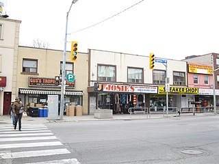
Earlscourt is a neighbourhood in Toronto, Ontario, Canada. It is centred on St. Clair Avenue West, with Dufferin Street, Davenport Road, and Old Weston Road forming its boundaries. It is contained within the larger city-recognized neighbourhood of Corso Italia-Davenport.

<span class="mw-page-title-main">Corso Italia (Toronto)</span> Neighbourhood in Toronto, Ontario, Canada

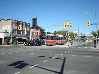
Corso Italia is a neighbourhood in Toronto, Ontario, Canada, situated on St. Clair Avenue West, between Westmount Avenue and Lansdowne Avenue. It is contained within the larger city-recognized neighbourhood of Corso Italia-Davenport.

<span class="mw-page-title-main">Bracondale Hill</span> Neighbourhood in Toronto, Ontario, Canada

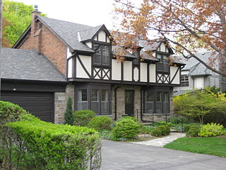
Bracondale Hill, also known as Hillcrest Village or Hillcrest, is a residential neighbourhood of Toronto, Ontario, Canada. Annexed by the old City of Toronto in 1909 and developed in 1911 from the Turner estate, Bracondale Hill is on the eastern border of West End Toronto; neighbouring Midtown, stretching above Davenport Road from the south, below St. Clair Avenue West from the north, Wychwood Park & Bathurst St. to the East and Winona Dr. to the West. This neighbourhood is home to the Hillcrest Village Business Improvement Area (BIA).

<span class="mw-page-title-main">Humber Valley Village</span> Neighbourhood in Toronto, Ontario, Canada

Humber Valley Village is a neighbourhood located in Toronto, Ontario, Canada. It is within the former suburb of Etobicoke and includes some of the most expensive real estate in the metropolitan west end. The boundaries are from Dundas Street on the south to Islington Avenue to the west, Eglinton Avenue to the north, and the Humber River in the east. The neighbourhood is in the political riding of Etobicoke Centre.

<span class="mw-page-title-main">Clanton Park, Toronto</span> Neighbourhood in Toronto, Ontario, Canada

Clanton Park is a neighbourhood in Toronto, Ontario, Canada. Located in the district of North York, it is part of federal and provincial electoral district York Centre, and Toronto electoral wards 9: York Centre (West) and 10: York Centre (East). In 2006, it had a population of 13,035.

<span class="mw-page-title-main">Fairbank, Toronto</span> Neighbourhood in Toronto, Ontario, Canada

Fairbank is a neighbourhood in Toronto, Ontario, Canada. The area is centred on the intersection of Dufferin Street and Eglinton Avenue West. Fairbank includes the neighbourhoods of Briar Hill–Belgravia and Caledonia–Fairbank. The western border is the CNR lines. The northern and southern borders are the former borders of the City of York and the eastern border is Dufferin Street.

<span class="mw-page-title-main">Vaughan Road</span> Thoroughfare in Toronto, Ontario

Vaughan Road is a road in Toronto, Ontario, Canada. It is a contour collector road that is parallel to a buried creek to the north called Castle Frank Brook. Vaughan Road begins on Bathurst Street south of St. Clair Avenue West, then it becomes a north–south street, hence its address numbering system, then it becomes a northwest–southeast street. Finally, Vaughan Road ends in a dead-end near Fairbank station at the intersection of Eglinton Avenue and Dufferin Street. Vaughan Road Academy is named after this road.

<span class="mw-page-title-main">Carleton Village</span> Neighbourhood in Toronto, Ontario, Canada

Carleton Village is a neighbourhood in the city of Toronto, Ontario, Canada. It is centered along Davenport Road, south of St. Clair Avenue West and surrounded on the other three sides by railway lines. The CNR/CPR mainline to the west, the CNR railway lines to the east, and the CPR east–west railway lines to the south.

<span class="mw-page-title-main">Lansdowne Avenue</span> Thoroughfare in Toronto, Ontario

Lansdowne Avenue is an arterial road in Toronto, Ontario. It runs north–south and starts at Queen Street West and proceeds north to St. Clair Avenue West. Lansdowne Avenue is primarily a four-lane arterial road, with two lanes regularly used for motor vehicle parking.

<span class="mw-page-title-main">Oakwood Village</span> Neighbourhood in Toronto, Ontario, Canada

Oakwood Village, formerly known as Oakwood–Vaughan, is a neighbourhood in Toronto, Ontario, Canada. Located in the former suburb of York, the neighbourhood is a Business Improvement Area (BIA); it has an annual arts festival and a public library built in 1997.

<span class="mw-page-title-main">Bracondale</span> Provincial electoral district in Ontario, Canada

Bracondale was a provincial electoral district in Toronto, Ontario, Canada. It was represented in the Legislative Assembly of Ontario from 1926 to 1967. The constituency got its name from an old Toronto suburb called Bracondale, that was annexed by Toronto in 1909. Its most notable event was electing one of the first two women Members of the Provincial Parliament (MPP) to share the title "first-woman MPP" in 1943 when Rae Luckock was elected. In 1965, Bracondale's MPP, Joseph Gould, died in office sparking the final election held in the constituency. George Ben won the by-election, and became the constituency's last MPP. It was abolished for the 1967 Ontario provincial election, and redistributed into the Dovercourt and Bellwoods constituencies. As of 2022, the current electoral districts of Davenport, St. Paul's, University–Rosedale, and Spadina–Fort York encompass this historic riding.

<span class="mw-page-title-main">Davenport Road</span> Thoroughfare in Toronto, Ontario

Davenport Road is an east–west arterial road in Toronto, Ontario, Canada. It is believed to follow an old native trail along the foot of the scarp of the old shoreline of glacial Lake Iroquois. It currently runs from Yonge Street in the east to Old Weston Road in the west.

<span class="mw-page-title-main">Bartholomew Bull</span>

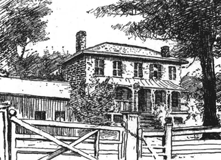
Bartholomew Bull was an immigrant to Upper Canada, who arrived at York, with his wife and his first-born child in 1818. In 1824 he acquired his own parcel of land, 200 acres on the brow of the Lake Iroquois Escarpment, between what is now Dufferin Street and Ossington Avenue, north of Davenport Road, and south of St. Clair Avenue.

References