Sillajhuay

Last updated

Sillajhuay
Alto Toroni, Sillajguay
Alto Toroni from the west.jpg
Sillajhuay seen from the west
Highest point
Elevation 5,982 m (19,626 ft) [1]
Prominence 1,733 m (5,686 ft) [2]
Parent peak Nevado Sajama
Listing Ultra,
Coordinates 19°44′32″S68°41′26″W / 19.74222°S 68.69056°W / -19.74222; -68.69056 [3]
Geography
Bolivia physical map.svg
Red triangle with thick white border.svg
Sillajhuay
Location in Bolivia, on the border with Chile
Location BoliviaChile border;Oruro, Arica y Parinacota
Parent range Andes
Geology
Age of rock Pliocene-recent
Mountain type Volcano
Volcanic arc/belt Central Volcanic Zone
Climbing
First ascent pre columbian but first recorded ascent 1926 - Friedrich Adolf Ernest Ahlfeld (Germany) [4]
Sillajhuay seen from ISS ISS028-E-21752 - View of Bolivia.jpg
Sillajhuay seen from ISS

Sillajhuay (also known as Sillajguay or Alto Toroni) is a volcano on the border between Bolivia and Chile. It is part of a volcanic chain that stretches across the border between Bolivia and Chile and forms a mountain massif that is in part covered by ice; whether this ice should be considered a glacier is debatable but it has been retreating in recent decades.

Contents

The volcano has developed on top of older ignimbrites. The volcano was active within the last one million years, but not within recent times considering the heavy glacial erosion of the mountain and the widespread periglacial modifications. Non-eruptive activity however occurs in the form of surface deformation and earthquake activity.

Geography and geomorphology

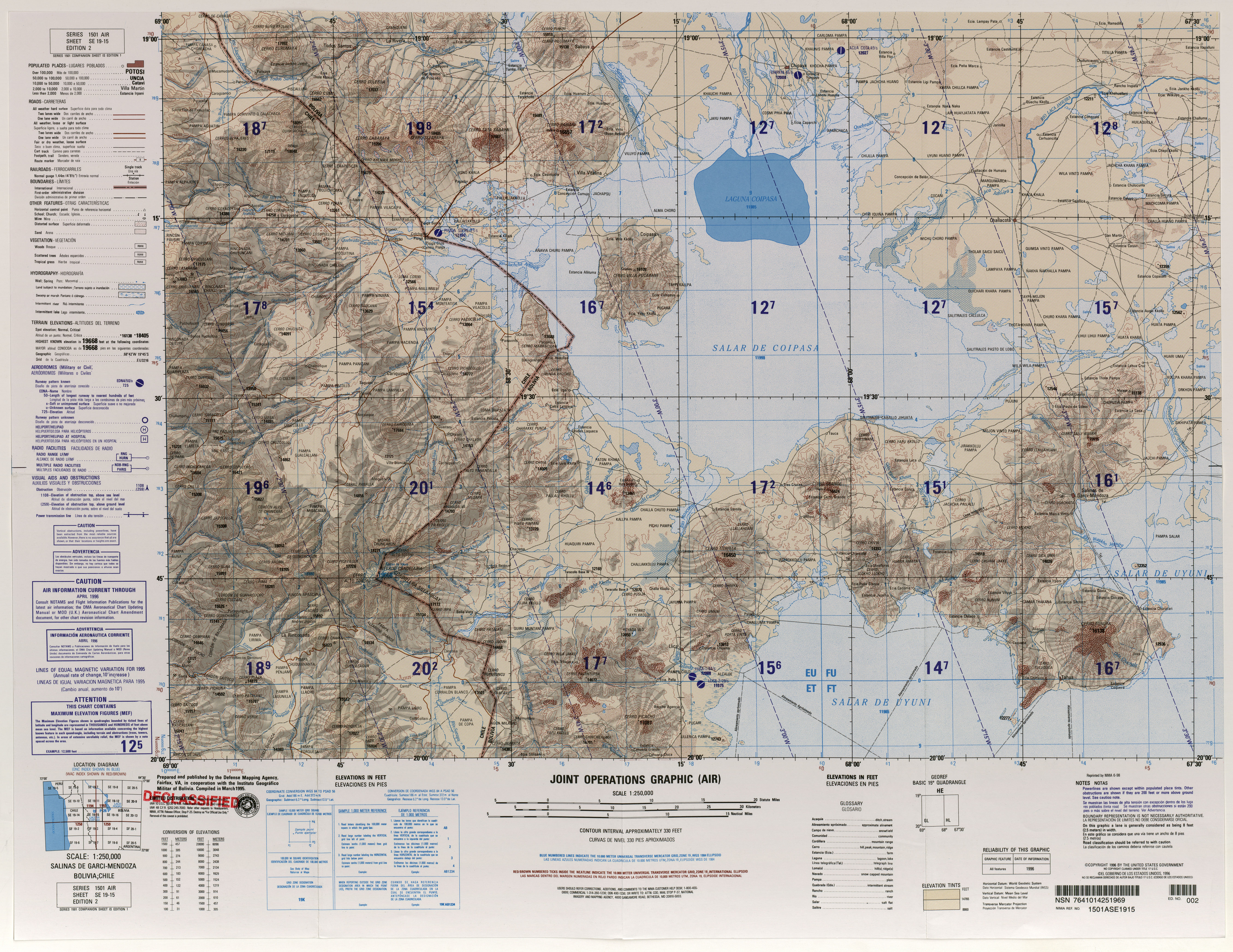
Sillajhuay is located in the Andes on the border between Bolivia and Chile (commune of Pica-Colchane, [5] Tarapaca Region [6] ) although only a small easterly sector of the mountain is located in Bolivia. [7] [8] The volcano lies in a thinly inhabited region; [9] the towns of Cancosa and Villa Blanca lie 16 kilometres (9.9 mi) southeast and 18 kilometres (11 mi) northeast of Sillajhuay, respectively, [7] and a road runs west of the volcano. [10] The volcano is also known as Alto Toroni, [11] Sillajguay, [3] or sometimes Candelaria. [12] The name "Sillajhuay" means "devil's chair" in Aymara [13] but the part silla may also refer to sila which means llama. [14]

About 50 different volcanoes and geothermal features have been active in the Central Andes during the Holocene, [15] with earthquakes observed at Guallatiri, Irruputuncu, Isluga, Lascar, Olca, Parinacota and Putana. [16] Most volcanoes of the Central Volcanic Zone (CVZ) are relatively poorly researched and many exceed 5,000 metres (16,000 ft) of elevation. Some of these volcanoes were active during historical time; these include El Misti, Lascar, San Pedro and Ubinas; [17] the largest historical eruption of the CVZ occurred in 1600 at Huaynaputina. [18] Other volcanoes in the CVZ that have been the subject of research are Galan and the Purico complex. [19] The CVZ has a characteristically thick crust (50–70 kilometres (31–43 mi)) and the volcanic rocks have peculiar oxygen and strontium isotope ratios in comparison to the Southern Volcanic Zone (SVZ) and the Northern Volcanic Zone (NVZ). [20]

The mountain is most commonly stated to be maximally 5,995 metres (19,669 ft) high, [1] [21] but a higher heights or a lower height of 5,982 metres (19,626 ft) are also possible. [12] [lower-alpha 1] [lower-alpha 2] It is the highest peak in the region. Sillajhuay is part of a larger massif that rises 2,000 metres (6,600 ft) above the surrounding flat pedimented terrain to a median elevation of 5,030 metres (16,500 ft) elevation. [27] Subsidiary summits in the massif include the 5,060 metres (16,600 ft) high Cerro Carvinto southwest of Sillajhuay, [27] the 5,403 metres (17,726 ft) Cerro Picavilque west-northwest of Sillajhuay, 5,234 metres (17,172 ft) high Cerro Irpa southeast, Cerro Candelaria due east and 5,874 metres (19,271 ft) Morro Chuncaron and Alto Totoni northeast. [28] Generally, the massif is elongated northeastwards [1] and its summit region is poorly accessible. [27] Above 4,100 metres (13,500 ft) elevation, glaciation has eroded the massif and thus the volcano is heavily degraded with no recognizable craters; below that elevation volcanic landforms are more clearly expressed. The volcano was the source of 30–90 metres (98–295 ft) thick lava flows that reached lengths of about 14–5 kilometres (8.7–3.1 mi) [29] and valleys occur all around it. [8] Farther west lie the Cerros de Quimsachata which form a volcanic chain with Sillajhuay. [10] [30] [8]

Glaciation

Firn including penitentes occurs on the mountain at elevations of over 5,750 metres (18,860 ft) [31] and is visible over large distances [32] but there are no presently active, moving glaciers [31] unless they are buried beneath a snow cover. [8] Some sources consider Sillajhuay's firn a glacier however, in which case it would be considered to be the southernmost glacier north of the Arid Diagonal of the Andes. [33] Between 1989 and 2011 the firn lost over half of its surface, interrupted by some small advances, [34] and further retreat is likely. [35] Ice loss between 2000 and 2003 amounted to about 0.03 square kilometres (0.012 sq mi). [36]

In the past during the Late Quaternary, the mountain was more extensively glaciated, with about nine glaciers surrounding it including a subsidiary summit to the south. [37] Former glaciers did reach lengths of 11 kilometres (6.8 mi) and their tongues descended to elevations of 4,240 metres (13,910 ft) [38] on the northern, eastern and southern flanks; [39] they have left well developed glacial striae, glacial valleys and various types of moraines. [38] The lowest moraines are found on the eastern flank, with the northern flanks having the highest moraines and the southern flank moraines reaching intermediate elevations. [40] Some ancient tills have been overrun by porphyries. [41] The extent of glacial erosion suggests that at least two stages of glaciation occurred at Sillajhuay. [42]

Some rock glaciers are found on the southern side of Sillajhuay [43] and mostly in the Rincon Tucuruma valley; [44] they occur at elevations of 5,200 metres (17,100 ft) and the longest reaches a length of 500 metres (1,600 ft). [43] Solifluction landforms and other surfaces generated by periglacial processes are common on the southern and northern-northwestern flanks of the massif. [45]

Hydrography

Erosion has cut steep valleys into the massif; these include clockwise the Rio Blanco southeast, Ricon Tacurma south, Quebrada Mina Chucha southwest, Quebrada Seca northwest and Quebrada Quisimachiri north-northwest of the volcano. [1] These valleys reach up to the summit plateau [46] and contain perennial rivers; additional valleys contain ephemeral streams, [47] and they are often linked to alluvial fans down where eroded material has been deposited. [48] Sulfurous springs are active on the massif. [49]

The valleys descending the volcano have steep slopes, the Rio Blanco valley for example has a 1.1 kilometres (0.68 mi) drop over 2 kilometres (1.2 mi). [50] All the drainages from Sillajhuay [30] eventually flow eastward [51] towards the Salar de Coipasa. [52] On the southern flank of Sillajhuay, the Rio Blanco and the Ricon Tacurma drain into the Rio Ocacucho; [53] there was formerly a lake known as the Cancosa paleolake south of Sillajhuay. [1] There is evidence that during the middle Pleistocene, a landslide from Sillajhuay dammed the Rio Cancosa and generated a body of water, [54] into which the Cancosa Strata formation was deposited. [55] Farther west, away from Sillajhuay, [30] drainages conversely descend to the Pampa del Tamarugal. [52]

Geology

The Nazca Plate and Antarctic Plate subduct beneath the South America Plate in the Peru-Chile Trench at a pace of 7–9 centimetres per year (2.8–3.5 in/year) and 2 centimetres per year (0.79 in/year), respectively, resulting in volcanic activity and geothermal manifestations in the Andes. [56] [18] Present-day volcanism occurs within four discrete belts: the NVZ (between 2°N–5°S), the CVZ (16°S–28°S), the SVZ (33°S–46°S) and the Austral Volcanic Zone (AVZ) (49°S-55°S). [18] [20] [57] Between them they contain about 60 active volcanoes and 118 volcanoes which appear to have been active during the Holocene, not including potentially active very large silicic volcanic systems or very small monogenetic ones. [18] These belts of active volcanism occur where the Nazca Plate subducts beneath the South America Plate at a steep angle, while in the volcanically inactive gaps between them the subduction is much shallower; [58] thus there is no asthenosphere between the slab of the subducting plate and the overriding plate in the gaps. [18]

Among the oldest volcanics in the region are Eocene effusive andesitic volcanics known as the Icanche Formation and associated subvolcanic bodies, such as the Alantaya intrusive complex. These also include granodioritic to tonalitic plutons. During the Eocene-Oligocene Incaic deformation phase this basement was uplifted and eroded and subsequently covered by rhyolitic ignimbrites called the Utayane Formation. Along with the Utayane, andesitic volcanism led to the emplacement of additional andesitic lava formations such as the Puchuldiza and Chojña Chaya Formations. [59] Rhyolitic ignimbritic volcanism however continued and was accompanied during the Miocene by the uplift of mountain ranges. Eventually large central volcanoes developed during the Miocene and Pliocene and are mostly uneroded and not affected by tectonic deformation. Sillajhuay developed during this time period. Finally, the mountains were altered by at least two cycles of glaciation. [54]

Local

The regional geography is characterized by north–south trending mountain chains which are separated by relatively flat plains covered by Quaternary sediments. [60] Sillajhuay lies on top of older ignimbrites, which in turn were emplaced on top of granitic, sedimentary and volcanic rocks of Paleozoic to Mesozoic age. [61] Some of these ignimbrites have been identified as the 19.38 million years old Oxaya Ignimbrite, the much younger Ujina Tsu ignimbrite and finally the Pastillos Ignimbrite. [62]

Tectonic stress during the subduction process has led to the development of a horst that Sillajhuay is part of, perpendicular to the main strike of the Andes [1] where magma formation was increased. [63] The mountain is also part of the Serranía Intersalar mountain chain which separates the Salar de Coipasa from the Salar de Uyuni and lacks recent volcanic activity. [64] Another isolated volcano Cerro Cariquima rises north of Sillajhuay, [7] the volcanic centres of Churullo northwest and the volcanic chain Pumiri northeast of Sillajhuay form the rest of the neighbouring centres. [65]

The volcano is formed by dacite and porphyry, [61] including sulfur-containing porphyry which has a yellow colour [52] and solfataric deposits; [66] the volcanic rocks define a potassium-rich calc alkaline suite. [63] Phenocrysts include plagioclase, with less common biotite, hornblende and quartz. [61] Isotope ratios of volcanic rocks indicate a strong crustal influence on the magmas that were erupted at Sillajhuay. [67]

Climate and vegetation

The mountain lies in an arid region and features a montane climate; estimated precipitation rises from 200 millimetres per year (7.9 in/year) at 4,500 metres (14,800 ft) to 300–400 millimetres per year (12–16 in/year) at 5,000 metres (16,000 ft) elevation [51] mostly during summer, although rainfall might exceed 400 millimetres per year (16 in/year). During the night the temperatures can fall to under −20 °C (−4 °F). [9] Grasses and shrubs with rare trees form the vegetation, [51] mostly on the eastern flank and sometimes reaching high elevations. Among the plant species that grow in the area are yareta plants. [68]

The dry climate is caused by the South East Pacific High and compounded by the Humboldt Current off the coast, which cools the atmosphere and reduces evaporation. Only during the summer months does convection on the Bolivian Altiplano lead to the arrival of moisture, leading to a predominant summer precipitation. The climate becomes even drier farther south. [69] Cut-off lows can sometimes reach Sillajhuay in winter but are uncommon. [70] In the past, such as 28,000, 8,000 and 3,700 - 1,500 years ago the climate was more humid [71] and this led frequently to glacier advances when it was also cold enough. [72] In return, glaciers on Sillajhuay may have enhanced the moisture supply to other mountains in the area such as Chuquiananta, allowing them to develop glaciers as well. [8]

The strong insolation leads to a strongly diurnal temperature cycle on the mountain with a day-night temperature gradient of about 45 K (81 °F) that in some environments can increase to over 80 K (140 °F); [73] there are thus active freeze-thaw cycles. [51] The warming also leads to the development of mountain breeze and valley breeze, convective clouds as well as occasional landspouts. [74]

Human activity

The summit of Sillajhuay can be climbed and features Inca ruins on the summit; there are a number of such high altitude ruins in the Andes such as at Llullaillaco. This site was discovered in 2013 by the Scottish mountaineer John Biggar. [12] Mining takes place east of Sillajhuay, [27] including sulfur mines; [75] estimated deposits are 3,200,000 tonnes (3,100,000 long tons; 3,500,000 short tons) of ore with 47% sulfur. [76] The area has also been prospected for the possibility of obtaining geothermal power. [77] The first recorded climb was by Friedrich Adolf Ernest Ahlfeld (Germany) in 1926. [78]

Eruptive history

The whole volcano is considered to be of Pliocene-Pleistocene age, although the lack of detailed study precludes a precise dating of volcanic activity. [77] The strong glacial modification implies that volcanism at Sillajhuay took place during the older Pleistocene. The maximum age of 730,000 ± 160,000 years is set by the age of the underlying ignimbrites [61] although dates obtained directly on the volcanic rocks from Sillajhuay imply ages of as much as 2.47 ± 0.06 million years ago. [29] Most volcanic activity probably took place around 600,000 - 400,000 years ago [62] with potassium-argon dating yielding an age of 890,000 ± 500,000 years ago. [79] Very young activity may have formed some gravel plains in the river valleys, when the heat from the eruption melted the permafrost of the summit region. [80]

However, between 2007 and 2010 a ground uplift of about 6 centimetres (2.4 in) was observed as Sillajhuay over an area 30 kilometres (19 mi) wide. In addition seismic activity was recorded at the volcano, and hot springs can be observed close to Sillajhuay, [77] including the Pampa Lirima field 25 kilometres (16 mi) southwest of Sillajhuay. [81] These patterns indicate that magma may still exist below the volcano [82] and that it should be classified as a potentially active volcano. [83]

See also

Notes

  1. Other data from digital elevation models: SRTM yields 5,981 metres (19,623 ft), [22] ASTER 5,966 metres (19,573 ft), [23] SRTM filled with ASTER5,981 metres (19,623 ft), [23] ALOS 5,966 metres (19,573 ft) [24] and TanDEM-X 6,023 metres (19,760 ft). [25]
  2. The height of the nearest key col is 4,262 metres (13,983 ft), [26] leading to a topographic prominence of 1,733 metres (5,686 ft) with a topographical dominance of 28.91%. Its parent peak is Sajama and the Topographic isolation is 183.8 kilometres (114.2 mi). [21]

Related Research Articles

<span class="mw-page-title-main">Ojos del Salado</span> Highest volcano in the world

Nevado Ojos del Salado is a dormant complex volcano in the Andes on the Argentina–Chile border. It is the highest volcano on Earth and the highest peak in Chile. The upper reaches of Ojos del Salado consist of several overlapping lava domes, lava flows and volcanic craters, with an only sparse ice cover. The complex extends over an area of 70–160 square kilometres (27–62 sq mi) and its highest summit reaches an altitude of 6,893 metres (22,615 ft) above sea level. Numerous other volcanoes rise around Ojos del Salado.

<span class="mw-page-title-main">Ollagüe</span> Stratovolcano in Bolivia and Chile

Ollagüe or Ullawi is a massive andesite stratovolcano in the Andes on the border between Bolivia and Chile, within the Antofagasta Region of Chile and the Potosi Department of Bolivia. Part of the Central Volcanic Zone of the Andes, its highest summit is 5,868 metres (19,252 ft) above sea level and features a summit crater that opens to the south. The western rim of the summit crater is formed by a compound of lava domes, the youngest of which features a vigorous fumarole that is visible from afar.

<span class="mw-page-title-main">Miñiques</span> Volcanic complex in Chile

Miñiques is a massive volcanic complex containing a large number of craters, lava domes and flows, located in the Antofagasta Region of Chile. Located 21 km (13 mi) south of Volcán Chiliques and 26 km (16 mi) west of Cordón Puntas Negras, it is part of a frequently visited attraction conformed by the high plain lagoons Laguna Miscanti, Laguna Miñiques and the Cerro Miscanti volcano.

<span class="mw-page-title-main">Purico complex</span> Pleistocene volcanic complex in Chile

The Purico complex is a Pleistocene volcanic complex in Chile close to Bolivia, formed by an ignimbrite, several lava domes and stratovolcanoes and one maar. It is in the Chilean segment of the Central Volcanic Zone, one of the four volcanic belts which make up the Andean Volcanic Belt. The Central Volcanic Zone spans Peru, Bolivia, Chile and Argentina and includes 44 active volcanoes as well as the Altiplano–Puna volcanic complex, a system of large calderas and ignimbrites of which Purico is a member. Licancabur to the north, La Pacana southeast and Guayaques to the east are separate volcanic systems.

<span class="mw-page-title-main">San Pedro (Chile volcano)</span> One of the tallest active volcanoes in the world

San Pedro is a Holocene composite volcano in northern Chile and one of the tallest active volcanoes in the world. Part of the Chilean Andes' volcanic segment, it is part of the Central Volcanic Zone of the Andes, one of the four tracts of the Andean Volcanic Belt. This region of volcanism includes the world's two highest volcanoes Ojos del Salado and Llullaillaco. San Pedro, like other Andean volcanoes, was formed by the subduction of the Nazca Plate beneath the South America Plate. It has a neighbouring volcano, San Pablo, and is itself formed by two separate edifices usually known as the Old Cone and the Young Cone. These edifices are formed by rocks ranging from basaltic andesite over andesite to dacite and are emplaced on a basement formed by Miocene volcanic rocks.

<span class="mw-page-title-main">Cerro del Azufre</span> Mountain in Chile

Cerro del Azufre is a stratovolcano located in El Loa Province, Antofagasta Region, Chile. It is part of a chain of volcanoes that separate Upper Loa River basin from Salar de Ascotán basin and is flanked to the west by a dacitic lava dome called Chanka or Pabellón. The 6000 metre volcanoes San Pedro and San Pablo are located to the southwest of Cerro del Azufre.

<span class="mw-page-title-main">Palpana</span>

Palpana is a volcano in the Andes of Chile. It has a summit elevation of 6,040 metres (19,820 ft).

<span class="mw-page-title-main">La Pacana</span> Large Miocene-age caldera in northern Chile

La Pacana is a Miocene age caldera in northern Chile's Antofagasta Region. Part of the Central Volcanic Zone of the Andes, it is part of the Altiplano-Puna volcanic complex, a major caldera and silicic ignimbrite volcanic field. This volcanic field is located in remote regions at the Zapaleri tripoint between Chile, Bolivia and Argentina.

<span class="mw-page-title-main">Cerro Porquesa</span>

Cerro Porquesa (Aymara) is an approximately 4,600 metres (15,100 ft) high rhyodacite lava dome in the Andes. It has a 1.5 by 3 kilometres oval outline, and is 800 metres (2,600 ft) high. The lava dome is accompanied by block-and-ash flows and lava flows and the presence of two volcanic cones has been reported. The lava dome is of Pliocene/Pleistocene age with little glacial features on the younger domes indicating young ages. The Quebrada de Piga, which flows to Salar de Huasco, originates at Cerro Porquesa.

Irruputuncu is a volcano in the commune of Pica, Tamarugal Province, Tarapacá Region, Chile, as well as San Pedro de Quemes Municipality, Nor Lípez Province, Potosí Department, Bolivia. The mountain's summit is 5,163 m (16,939 ft) high and has two summit craters—the southernmost 200 m (660 ft)-wide one has active fumaroles. The volcano also features lava flows, block and ash flows and several lava domes. The volcano is part of the Andean Central Volcanic Zone (CVZ).

Jotabeche is a Miocene-Pliocene caldera in the Atacama Region of Chile. It is part of the volcanic Andes, more specifically of the extreme southern end of the Central Volcanic Zone (CVZ). This sector of the Andean Volcanic Belt contains about 44 volcanic centres and numerous more minor volcanic systems, as well as some caldera and ignimbrite systems. Jotabeche is located in a now inactive segment of the CVZ, the Maricunga Belt.

<span class="mw-page-title-main">Sairecabur</span> Volcano between Bolivia and Chile

Sairecabur is a volcano located on the frontier between Bolivia and Chile. It is part of the Andean Central Volcanic Zone. Sairecabur proper is 5,971 m (19,590 ft) high; other mountains in the range are 5,722 m (18,773 ft) high Curiquinca, 5,819 m (19,091 ft) high Escalante and 5,748 m (18,858 ft) high Cerro Colorado, all of which have erupted a number of lava flows. Also in close proximity to Sairecabur lie the volcanic centres Licancabur, Putana and Juriques.

<span class="mw-page-title-main">Llullaillaco</span> Dormant stratovolcano at the border of Argentina and Chile

Llullaillaco is a dormant stratovolcano at the border of Argentina and Chile. It lies in the Puna de Atacama, a region of tall volcanic peaks on a high plateau close to the Atacama Desert, one of the driest places in the world. It is the second highest active volcano in the world after Ojos del Salado.

<span class="mw-page-title-main">Olca-Paruma</span> Volcanic complex in Chile

Olca-Paruma is a volcanic complex in Chile. Lying on the border between Chile and Bolivia, it is formed by an east–west alignment of volcanoes. From west to east, these are Cerro Paruma, Volcan Paruma, Olca, and Mencheca or Michincha. Aside from the mines of Ujina, Rosario, and Quebrada Blanca, the area is sparsely populated.

The paleolake of Cancosa is a former lake at Cancosa, Chile. The existence of the lake was inferred on the basis of limnic sediments in the area, which lies in the Tarapacá Region of Chile.

<span class="mw-page-title-main">Tocorpuri</span> Volcano in Bolivia and Chile

Tocorpuri is a volcano in Chile, close to the border with Bolivia. Its peak height is most recently given as 5,808 metres (19,055 ft) and it features a 1.3 kilometres (0.81 mi) wide summit crater. The volcano consists mainly of lava flows and pyroclastic deposits and is subdivided into two separate edifices. Just west of Tocorpuri, the La Torta lava dome is a 200 metres (660 ft) high flat-topped structure. The volcanoes are formed by andesitic, dacitic and rhyolitic rocks.

<span class="mw-page-title-main">Cerro Overo</span> Volcanic crater in Chile

Cerro Overo is a volcanic crater in Chile. It lies at the foot of Chiliques volcano and close to Laguna Lejía, over ignimbrites of Pliocene age erupted by the La Pacana volcano. It is 480 by 580 metres wide and 72 metres (236 ft) deep and formed through combined explosive-effusive eruptions. The lavas are of lower crustal provenience and are among the least silicic in the region.

<span class="mw-page-title-main">Nevado Tres Cruces</span> Volcanic massif in the Andes

Nevado Tres Cruces is a massif of volcanic origin in the Andes Mountains on the border of Argentina and Chile. It has two main summits, Tres Cruces Sur at 6,748 metres (22,139 ft) and Tres Cruces Centro at 6,629 m (21,749 ft) and a third minor summit, Tres Cruces Norte 6,030 m (19,780 ft). Tres Cruces Sur is the sixth highest mountain in the Andes.

Tilocálar is a group of volcanoes south of the Salar de Atacama, in Chile. It developed during the Pleistocene and consists of a small lava dome, two vents with numerous thick lava flows that reach lengths of several kilometres, and an explosion crater that was mistaken for an impact crater in the past. There are similar volcanoes nearby.

Coranzulí is a Miocene caldera in northern Argentina's Jujuy Province. Part of the Argentine Andes' volcanic segment, it is considered a member of the Central Volcanic Zone (CVZ). At the heart of the CVZ lies the Altiplano-Puna volcanic complex, a group of volcanoes of which Coranzulí is a part: the complex has produced large ignimbrite sheets with a combined volume approaching 15,000 cubic kilometres (3,600 cu mi).

References

  1. 1 2 3 4 5 6 Kamp, Bolch & Olsenholler 2002, p. 2.
  2. "Alto Toroni / Sillajguay/ Candelaria". Andes Specialists. Retrieved 2020-04-12.
  3. 1 2 "Cordillera de Sillajhuay". GEOnet Names Server . Retrieved 16 June 2018.
  4. Pietro Meciani. Le Ande. p. 72.
  5. Lobos 2013, p. 77.
  6. Lobos 2013, p. 78.
  7. 1 2 3 Schröder & Bolch 2001, p. 8.
  8. 1 2 3 4 5 Jenny & Kammer 1996, p. 47.
  9. 1 2 Schröder, Kröber & Bolch 1998, p. 5.
  10. 1 2 Gardeweg, Moyra P.; Delcorto, Luis A. (October 2015). Glaciares de roca en la Alta Cordillera de Iquique – Región de Tarapacá, Chile (PDF). 14th Chilean Geological Congress. biblioteca.sernageomin (in Spanish). La Serena. p. 726. Archived from the original (PDF) on June 22, 2018. Retrieved 22 June 2018.
  11. Schröder, Hilmar (1999). "Vergleichende Periglazialmorphologie im Sommerregengebiet der Atacama". Erdkunde. 53 (2): 123. doi:10.3112/erdkunde.1999.02.03.
  12. 1 2 3 Griffin, Lindsay (21 October 2013). "British climber discovers high altitude Inca ruins". British Mountaineering Council. Retrieved 22 June 2018.
  13. Bobylyova, E. S.; Сергеевна, Бобылева Елена (15 December 2016). "Structural-and-Semantic Analysis of Oronyms of Chile, Структурно-семантический анализ оронимов Чили". RUDN Journal of Language Studies, Semiotics and Semantics, Вестник Российского университета дружбы народов. Серия: Теория языка. Семиотика. Семантика (in Russian) (2): 126. ISSN   2411-1236.
  14. Uhle, Max (1919). "Fundamentos étnicos de la región de Arica y Tacna" (PDF). Boletin de la Sociedad Ecuatoriana de Estudios Historicos Americans. p. 28. Retrieved 5 March 2019.
  15. Pritchard et al. 2014, p. 90.
  16. Pritchard et al. 2014, p. 92.
  17. Karátson, D.; Telbisz, T.; Wörner, G. (15 February 2012). "Erosion rates and erosion patterns of Neogene to Quaternary stratovolcanoes in the Western Cordillera of the Central Andes: An SRTM DEM based analysis". Geomorphology. 139–140: 122. Bibcode:2012Geomo.139..122K. doi:10.1016/j.geomorph.2011.10.010.
  18. 1 2 3 4 5 Stern, Charles R. (1 December 2004). "Active Andean volcanism: its geologic and tectonic setting". Revista Geológica de Chile. 31 (2): 161–206. doi: 10.4067/S0716-02082004000200001 .
  19. Wörner et al. 1988, p. 288.
  20. 1 2 Davidson, Jon P.; McMillan, Nancy J.; Moorbath, Stephen; Wörner, Gerhard; Harmon, Russell S.; Lopez-Escobar, Leopoldo (1 September 1990). "The Nevados de Payachata volcanic region (18°S/69°W, N. Chile) II. Evidence for widespread crustal involvement in Andean magmatism". Contributions to Mineralogy and Petrology. 105 (4): 412. Bibcode:1990CoMP..105..412D. doi:10.1007/BF00286829. S2CID   54181266.
  21. 1 2 "Alto Toroni / Sillajguay/ Candelaria". Andes Specialists. Retrieved 12 April 2020.
  22. USGS, EROS Archive. "USGS EROS Archive - Digital Elevation - SRTM Coverage Maps" . Retrieved 12 April 2020.
  23. 1 2 "ASTER GDEM Project". ssl.jspacesystems.or.jp. Retrieved 14 April 2020.
  24. "ALOS GDEM Project" . Retrieved 14 April 2020.
  25. TanDEM-X, TerraSAR-X. "Copernicus Space Component Data Access". Archived from the original on 12 April 2020. Retrieved 12 April 2020.
  26. "Andean Mountains - All above 5000m". Andes Specialists. Retrieved 12 April 2020.
  27. 1 2 3 4 Schröder & Bolch 2001, p. 9.
  28. Defense Mapping Agency (1995). "Salinas de Garci-Mendoza Bolivia; Chile" (Map). Latin America, Joint Operations Graphic (2 ed.). 1:250000.
  29. 1 2 Selles, Gardeweg & Garibaldi 2018, p. 45.
  30. 1 2 3 Schröder, Kröber & Bolch 1998, p. 9.
  31. 1 2 Kamp, Bolch & Olsenholler 2002, p. 53.
  32. Schröder, Kröber & Bolch 1998, p. 39.
  33. Barcaza et al. 2017, p. 174.
  34. Lobos 2013, p. 82.
  35. Lobos 2013, p. 81.
  36. Barcaza et al. 2017, p. 177.
  37. Jenny & Kammer 1996, p. 48.
  38. 1 2 Kamp, Bolch & Olsenholler 2002, p. 54.
  39. Kamp, Bolch & Olsenholler 2002, p. 55.
  40. Ammann, Caspar; Jenny, Bettina; Kammer, Klaus; Messerli, Bruno (August 2001). "Late Quaternary Glacier response to humidity changes in the arid Andes of Chile (18–29°S)". Palaeogeography, Palaeoclimatology, Palaeoecology. 172 (3–4): 317. Bibcode:2001PPP...172..313A. doi:10.1016/S0031-0182(01)00306-6. ISSN   0031-0182.
  41. Kamp, Bolch & Olsenholler 2002, p. 56.
  42. Schröder, Kröber & Bolch 1998, p. 15.
  43. 1 2 Kamp, Bolch & Olsenholler 2002, p. 45.
  44. Schröder, Kröber & Bolch 1998, p. 31.
  45. Kamp, Bolch & Olsenholler 2002, pp. 5–6.
  46. Schröder, Kröber & Bolch 1998, p. 41.
  47. Kamp, Bolch & Olsenholler 2002, p. 19.
  48. Kamp, Bolch & Olsenholler 2002, p. 37.
  49. Kamp, Bolch & Olsenholler 2002, p. 39.
  50. Schröder, Kröber & Bolch 1998, p. 10.
  51. 1 2 3 4 Kamp, Bolch & Olsenholler 2002, p. 3.
  52. 1 2 3 Schröder & Bolch 2001, p. 6.
  53. Schröder, Bolch & Kröber 1999, p. 221.
  54. 1 2 Sellés, Gardeweg & Garibaldi 2015, p. 79.
  55. Selles, Gardeweg & Garibaldi 2018, p. 44.
  56. Tassi et al. 2010, p. 1.
  57. Wörner et al. 1988, p. 287,288.
  58. Wörner et al. 1988, p. 289.
  59. Sellés, Gardeweg & Garibaldi 2015, p. 78.
  60. Sellés, Gardeweg & Garibaldi 2015, p. 77.
  61. 1 2 3 4 Kamp, Bolch & Olsenholler 2002, p. 16.
  62. 1 2 Kamp, Bolch & Olsenholler 2002, p. 66.
  63. 1 2 Schröder & Bolch 2001, p. 16.
  64. Salisbury, Morgan J.; Kent, Adam J.R.; Jiménez, Néstor; Jicha, Brian R. (29 December 2014). "Geochemistry and 40Ar/39Ar geochronology of lavas from Tunupa volcano, Bolivia: Implications for plateau volcanism in the central Andean Plateau". Lithosphere. 7 (2): 96. doi: 10.1130/L399.1 . ISSN   1941-8264.
  65. Gonzalez-Ferran, Oscar (1994). Volcanes de Chile (1. ed.). Santiago, Chile: Instituto geografico militar. p. 132. ISBN   978-956-202-054-1.
  66. Harmon, Russell S.; Rapela, Carlos W. (1991). Andean Magmatism and Its Tectonic Setting. Geological Society of America. p. 248. ISBN   978-0-8137-2265-8.
  67. Schröder & Bolch 2001, p. 18.
  68. Kamp, Bolch & Olsenholler 2002, p. 21.
  69. Schröder & Bolch 2001, p. 12.
  70. Schröder, Kröber & Bolch 1998, p. 14.
  71. Kamp, Bolch & Olsenholler 2002, p. 67.
  72. Schröder, Bolch & Kröber 1999, p. 220.
  73. Schröder & Bolch 2001, pp. 13–14.
  74. Kamp, Bolch & Olsenholler 2002, p. 15.
  75. Brüggen, J. (April 1929). "Zur Glazialgeologie der chilenischen Anden". Geologische Rundschau (in German). 20 (1): 4–5. Bibcode:1929GeoRu..20....1B. doi:10.1007/bf01805072. ISSN   0016-7835. S2CID   128436981.
  76. Selles, Gardeweg & Garibaldi 2018, p. 66.
  77. 1 2 3 Pritchard et al. 2014, p. 96.
  78. Meciani, Pietro (1965). Le Ande. Bologna: Tamari. p. 72. OCLC   7594407.
  79. Selles, Gardeweg & Garibaldi 2018, p. 46.
  80. Schröder, Kröber & Bolch 1998, p. 43.
  81. Tassi et al. 2010, p. 2.
  82. Pritchard et al. 2014, p. 102.
  83. Ward, K. M.; Wilder, A.; Spica, Z.; Perkins, J. P.; Muir, D.; McFarlin, H.; Naranjo, J. A.; Legrand, D.; Lopez, T.; Jay, J. A.; Henderson, S. T.; Farrell, A.; Diez, M.; Díaz, D.; Potro, R. del; Comeau, M. J.; Alvizuri, C.; Unsworth, M. J.; Sunagua, M.; Sparks, R. S. J.; Minaya, E.; Finnegan, N. J.; Christensen, D. H.; Blundy, J.; West, M. E.; Gottsmann, J.; McNutt, S. R.; Zandt, G.; Michelfelder, G.; Silva, S. L. de; Pritchard, M. E. (1 June 2018). "Synthesis: PLUTONS: Investigating the relationship between pluton growth and volcanism in the Central Andes". Geosphere. 14 (3): 969. Bibcode:2018Geosp..14..954P. doi: 10.1130/GES01578.1 . hdl: 1983/cf804ce1-dcfa-4abf-b2e3-0f267f7feed1 .

Sources

Further reading