
Broadway is a road in the U.S. state of New York. Broadway runs from State Street at Bowling Green for 13 mi (21 km) through the borough of Manhattan and 2 mi (3.2 km) through the Bronx, exiting north from New York City to run an additional 18 mi (29 km) through the Westchester County municipalities of Yonkers, Hastings-On-Hudson, Dobbs Ferry, Irvington, and Tarrytown, and terminating north of Sleepy Hollow.

A pedestrian crossing is a place designated for pedestrians to cross a road, street or avenue. The term "pedestrian crossing" is also used in the Vienna and Geneva Conventions, both of which pertain to road signs and road traffic.

A pedestrian scramble, also known as scramble intersection and scramble corner (Canada), 'X' Crossing (UK), diagonal crossing (US), scramble crossing (Japan), exclusive pedestrian interval, or Barnes Dance, is a type of traffic signal movement that temporarily stops all vehicular traffic, thereby allowing pedestrians to cross an intersection in every direction, including diagonally, at the same time.

Queens Boulevard is a major thoroughfare in the New York City borough of Queens connecting Midtown Manhattan, via the Queensboro Bridge, to Jamaica. It is 7.5 miles (12.1 km) long and forms part of New York State Route 25.

The 34th Street–Herald Square station is an underground station complex on the BMT Broadway Line and the IND Sixth Avenue Line of the New York City Subway, and is the third-busiest station in the system with 39,672,507 passengers entering the station in 2017. It is located at Herald Square in Midtown Manhattan where 34th Street, Broadway and Sixth Avenue intersect, and is served by the:

The New York City Department of Transportation (NYCDOT) is the agency of the government of New York City responsible for the management of much of New York City's transportation infrastructure. Ydanis Rodriguez is the Commissioner of the Department of Transportation, and was appointed by Mayor Eric Adams on January 1, 2022. Former Commissioners have included Polly Trottenberg, Janette Sadik-Khan, and Iris Weinshall

New York State Route 24 (NY 24) is a 30.84-mile-long (49.63 km) east–west state highway on Long Island in the U.S. state of New York. The highway is split into two segments, with the longest and westernmost of the two extending 18.68 miles (30.06 km) from an interchange with Interstate 295 and NY 25 in the Queens Village section of the New York City borough of Queens to an intersection with NY 110 in East Farmingdale in the Suffolk County town of Babylon. The shorter eastern section, located in eastern Suffolk County, extends 12.16 miles (19.57 km) from an interchange with I-495 in Calverton to an intersection with County Route 80 (CR 80) in Hampton Bays.
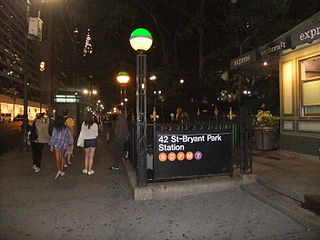
The 42nd Street–Bryant Park/Fifth Avenue station is an underground New York City Subway station complex, consisting of stations on the IRT Flushing Line and IND Sixth Avenue Line. Located at 42nd Street between Fifth Avenue and Sixth Avenue in Manhattan, it is served by the 7, D, and F trains at all time, B and M trains on weekday, and by ⟨7⟩ and ⟨F⟩ trains during rush hours in the peak direction.

57th Street is a broad thoroughfare in the New York City borough of Manhattan, one of the major two-way, east-west streets in the borough's grid. As with Manhattan's other "crosstown" streets, it is divided into its east and west sections at Fifth Avenue. The street runs from a small park overlooking the East River in the east to the West Side Highway along the Hudson River in the west. 57th Street runs through the neighborhoods of Sutton Place, Midtown Manhattan, and Hell's Kitchen from east to west.
53rd Street is a midtown cross street in the New York City borough of Manhattan, that runs adjacent to buildings such as the Citigroup building. It is 1.83 miles (2.94 km) long. The street runs westbound from Sutton Place across most of the island's width, ending at DeWitt Clinton Park at Eleventh Avenue.
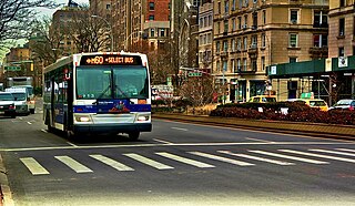
The M60 Select Bus Service is a bus route in New York City. It is part of MTA Regional Bus Operations, operated by the Manhattan and Bronx Surface Transit Operating Authority (MaBSTOA) under the New York City Transit brand. The M60 provides service between the Upper West Side of Manhattan and LaGuardia Airport in East Elmhurst, Queens, traveling between boroughs via the RFK-Triborough Bridge. It is the only direct public transit option between Manhattan and LaGuardia Airport.

51st Street is a 1.9-mile (3.1 km) long one-way street traveling east to west across Midtown Manhattan.

The West Street pedestrian bridges are a series of pedestrian bridges that cross West Street to connect the neighborhoods of Tribeca and the Financial District with Battery Park City in Lower Manhattan, New York City. The bridges were built to provide alternatives to crossing the busy street. Prior to the September 11 attacks, there were three bridges at Chambers Street, Vesey Street and Liberty Street. The Vesey Street and Liberty Street bridges connected the former World Trade Center complex with the World Financial Center.

The Williamsburg Bridge Plaza, sometimes called Washington Plaza or the Williamsburg Bridge Transit Center, is a major bus terminal and former trolley terminal located at the foot of the Williamsburg Bridge in the New York City borough of Brooklyn, one block west of the Brooklyn-Queens Expressway (I-278). It is situated by the boundaries of Broadway, Havemeyer Street, Roebling Street, and South 5th Street, south of the LaGuardia Playground. It contains five bus lanes, and serves as a terminal for numerous MTA New York City Transit Authority bus routes of Brooklyn and Queens that start and end their runs there.

The Q60 bus route constitutes a public transit line running primarily along Queens Boulevard in Queens, New York City, extending from Jamaica, Queens, to Midtown Manhattan via Queens Boulevard and the Queensboro Bridge. It is city-operated under the MTA Bus Company brand of MTA Regional Bus Operations.
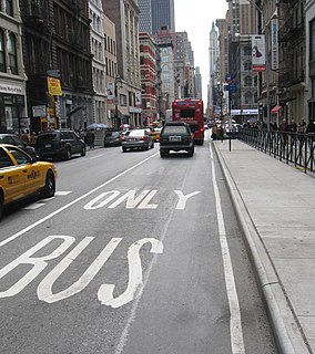
Since 1963, New York City has been using a system of bus lanes that are intended to give priority to buses, which contain more occupants than passenger and commercial vehicles. Most of these lanes are restricted to buses only at certain days and times, but some bus lanes are restricted 24/7. As of May 2021, there are 138.4 miles (222.7 km) of bus lanes within New York City.

The Q64, QM4 and QM44 bus routes constitute a public transit line in Queens, New York City. The east-to-west Q64 route runs primarily on Jewel Avenue operating between the Forest Hills–71st Avenue subway station in Forest Hills and 164th Street in Electchester. The QM4 route is an express bus route running from Midtown Manhattan to Electchester running via Sixth Avenue in Manhattan and Jewel Avenue in Queens. The QM44 route is an express bus route running from Midtown Manhattan to Electchester via Third Avenue in Manhattan and Jewel Avenue in Queens.

The 86th Street Crosstown Line is a bus line in Manhattan, New York City, running mostly along 86th Street on the Upper West and Upper East Sides of Manhattan. Originally a streetcar line, it now comprises the M86 Select Bus Service bus line.

450 Park Avenue is an office building on Park Avenue in Midtown Manhattan in New York City. The building has 33 floors and is 390 feet (120 m) tall.


